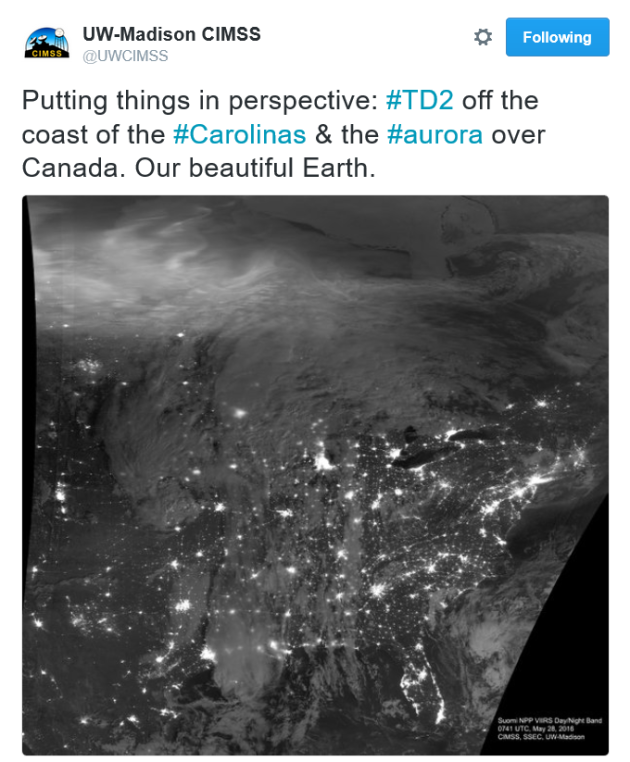
WOW! This is neat!! @UWCIMSS always comes up with amazing images, they are a great follow and like on social media as well! In the image below, you can see aurora (northern lights) over Canada along with Tropical Depression #2 SE of the Carolina Coast. Note that major city lights can also be seen across the Lower 48 from Friday night. So neat!
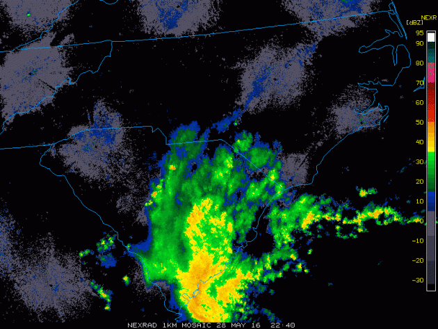
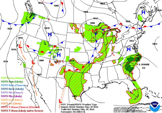
The radar loop below from PM Saturday showed the outer bands of Tropical Storm Bonnie pushing into South Carolina. These squalls will continue to bring gusty winds and heavy pockets of rain to areas along the Coast as the weekend continues. The other big concern will be a strong rip current potential.
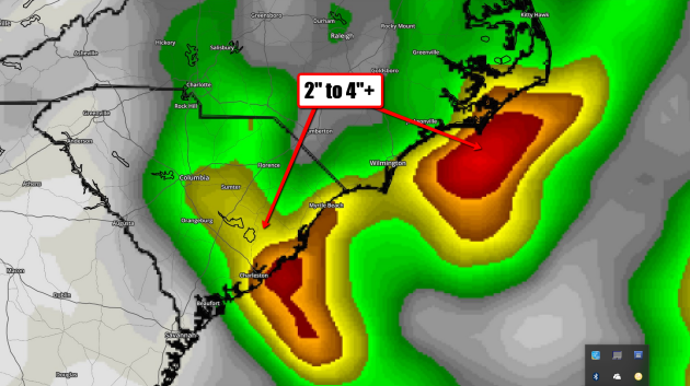
Rainfall Potential
Here's
the rainfall potential through the middle part of next week, which
suggests some 2" to 4"+ amounts. Heavy rainfall could lead to flood
concerns along the coast and for some inland locations.
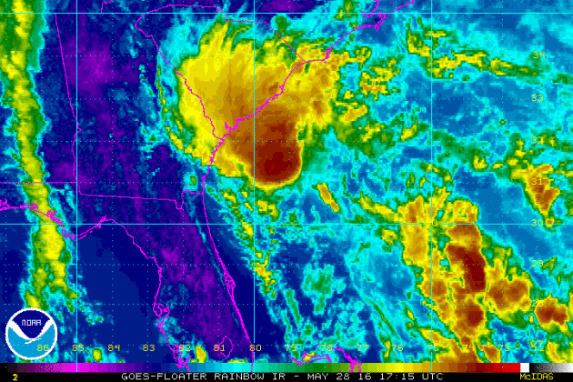
The IR satellite from PM Saturday showed a fairly large blob of intense clouds nearing the SE Coast associated with Tropical Storm Bonnie. This blob of moisture and unsettled weather will bring areas of heavy rainfall, gusty winds and RIP current potential along the coast through the holiday weekend.
Visible Satellite From Earlier Saturday...
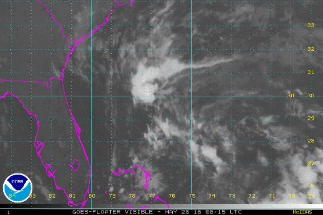
This
was the visible satellite view of then, TD #2 during sunrise on
Saturday. The IR satellite turns to visible satellite revealing more
definition in the clouds as TD #2 pushed closer to the SE coast.
Wind Circulation From Early Saturday...
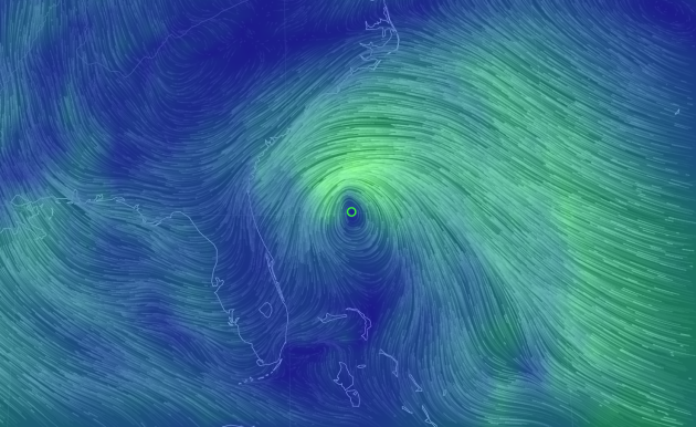
Wind
circulation from early Saturday showed strong winds on the
north/northwest side of the storm. This typically tends to be the worst
side of the as wind circulation tends to build up there also helping to
produce a higher storm surge there.
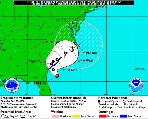
Here is the projected path for Bonnie through the middle part of next week. Note that after strengthening to Tropical Storm status, it appears to become a Tropical Depression as it hugs the Mid-Atlantic Coast through the early and middle part of next week. Interestingly, the Atlantic Hurricane Season officially starts on June 1st.
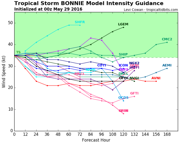
Here's
an interesting produce that suggests potential wind speeds over time.
Note that a few models keep this particular storm into Tropical Storm
strength over the next few days, while most models bring it back down
to Tropical Depression status.
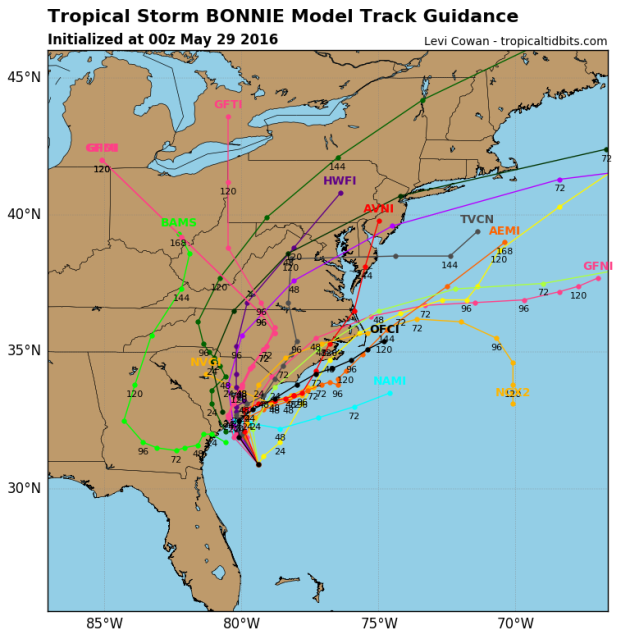
Model Paths
The
model path for this particular storm shows a pretty evident NE track
after the system tracks into South Carolina. This system will likely
pick up speeds as we head into next week as it start to encounter
stronger upper level winds, which may help to minimize the heavy
rainfall threat as some of the moisture lifts into parts of the NE.
_________________________
Getting Better - Even Nicer Memorial DayBy Todd Nelson, filling in for Douglas
Our somewhat soggy Saturday was a perfect day for lounging, wasn't it? I feel tired from being tired. However, being on the go so often, I don't feel guilty one bit! I hope you were able to catch up on a little R and R yourself.
Hey, on the bright side, 'most' lawns and gardens are happier now. Some of us won't have to water for a few days and I am all about a free lawn watering.
The heaviest, steadiest rains from Saturday, push east today. Wrap around clouds and a few stray PM T-showers can't be ruled out this afternoon, but it won't be a washout. Tomorrow looks even nicer with more sun and warmer temps. In fact, Memorial Day looks like the nicest day of the holiday weekend. Enjoy!
Meanwhile, the second tropical system of the 2016 Atlantic Hurricane Season and will impact folks in the Carolinas through early next week with squally rain and high rip current potential through early next week. Interestingly, the NHC is suggesting an above average year in the Atlantic basin due to a developing La Nina in the Pacific. Stay tuned.
_______________________________
Extended Forecast
SATURDAY NIGHT: Wet. showers and storms early. Low: 59. Winds: SW 5mph
SUNDAY: Sun and cloud mix. Stray afternoon T-storm possible. High: 79. Wind: W 8-13 mph.
MEMORIAL DAY MONDAY: Mild sun. Spotty PM thunder west. High: 80. Wind: SW 5mph.
MONDAY NIGHT: Increasing clouds. Showers and storms develop. Low: 61. Winds: ESE 5mph
TUESDAY: Scattered PM storms with locally heavy rain. Sticky. High: 77. Winds: SSE 10-15mph.
WEDNESDAY: Breezy. Stray PM rumble. Wake-up: 59. High: 72. Winds: WSW 10-15mph
THURSDAY: More sun, refreshing breeze. Wake-up: 53. High: 71. Winds: NNW 7-12mph.
FRIDAY: Bright sun. Thunder arrives overnight. Wake-up: 54. High: 74. Winds: WSW 5mph.SATURDAY: Warmer. Afternoon T-shower. Wake-up: 58. High: 75. Winds: SW 5mph.
______________________________________
This Day in Weather History
May 29
1949: An intense downpour dumps over 7 inches of rain at Thief River Falls.
1947: Extremely late season snow falls in southern Minnesota, northern Iowa, and southern Wisconsin. Worthington, MN picks up an inch, while some places in southern Wisconsin receive up to 6 inches.
______________________________________
Average High/Low for Minneapolis
May 29th
Average High: 73F (Record: 94F set in 2006)
Average Low: 53F (Record: 33F set in 1963)
______________________________________
Sunrise/Sunset Times for Minneapolis
May 29th
Sunrise: 5:31am
Sunset: 8:50pm
*Daylight Gained Since Yesterday: ~1min & 33secs
*Daylight Gain Since Winter Solstice: ~6hour & 35mins
*Length of Day: 15hours & 19mins
_______________________________________
Moon Phase for May 29th at Midnight
0.8 Days After Last Quarter
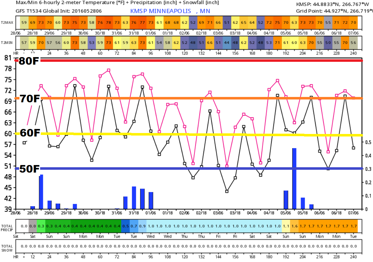
Extended Outlook
The extended outlook through the first few days of June suggests warmer than average temperatures continuing through the end of May. However, note the slight cool down as we get into the first part of June with highs dipping into the 60s. The good news is that overnight lows don't look to dip to far, so the threat for frost or freeze doesn't look imminent at this point.
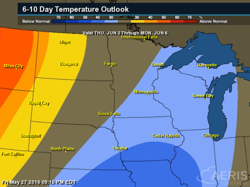
6 to 10 Day Temp Outlook
According to NOAA's CPC, the 6 to 10 day temperature outlook suggests a decent chance of below average temperatures returning to parts of the Midwest and Great Lakes Region from June 2nd to June 6th. Although temperatures may dip a bit, it doesn't look to be unbearable.
_______________________________________________
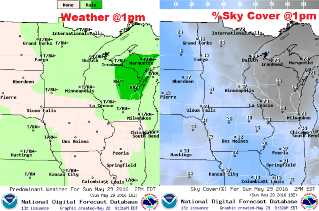
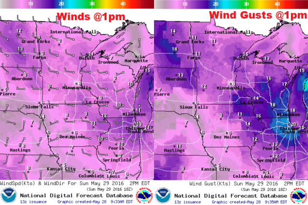
Sunday Weather Outlook
Sunday weather looks a little nicer across the region. It appears that we'll have a little more sunshine and it won't be quite as soggy. With that said, temperatures will still be fairly close to average with readings warming into the 70s across the state, but a few 80s may also be possible across southern MN. Dewpoints will be in the 50s, so it won't be too muggy.
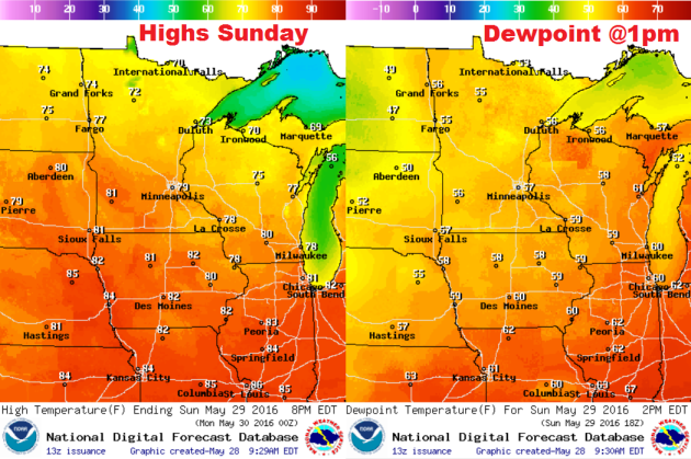
Sunday Weather Outlook
The
heaviest rainfall from Saturday looks to shift farther east, but a few
lingering showers and a few rumbles of thunder can't be ruled out on
Sunday. Note that there looks to be a little more sunshine the farther
SW you get.
Sunday Weather Outlook
Winds
won't be an issue on Sunday, but a few there there could be a few gusts
in the 10mph to 15mph range at points during the afternoon.
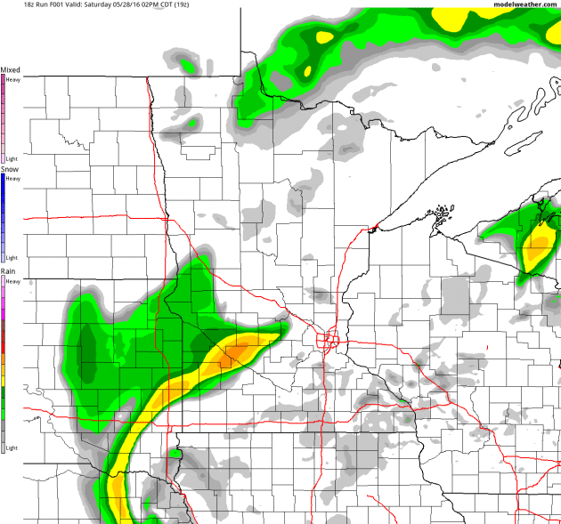
Simulated Radar
Here's
the simulated radar from midday Saturday to Monday night. Saturday
appears to be the wettest day of the weekend with a few lingering
showers and storms possible during the afternoon hours Sunday and a few
more developing late Monday night. However, weather conditions look
nicer on Memorial Day itself.
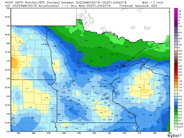
Rainfall Potential
Soggier
weather conditions on Saturday will begin to push east of the region on
Sunday. There appears to be a few lingering showers or storms on
Sunday, but the bulk of the additional moisture looks to move in late
Monday into Tuesday. The rainfall forecast through PM Tuesday suggests
another blast of somewhat significant rainfall of up to 1"+ in spots as
thunderstorm move back in.
_______________________________________
National Weather Outlook
The
national weather outlook through early next week shows slightly
improved weather conditions on Sunday across parts of the Central U.S.,
but another blob of heavier moisture looks to return to the Midwest as
Monday and Tuesday roll around. In fact, there could be some heavier
rainfall tallies any thunderstorms that develop there.
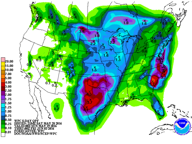
Precipitation Outlook
According
to NOAA's HPC, the rainfall potential through midweek next week
suggests some of the heaviest rainfall across parts of the Central and
Southern Plains. Some 2" to 4"+ tallies can't be ruled out, especially
across parts of Oklahoma and Texas, where those amounts may be a little
more widespread. Also note the heavier band of rain along the East Coast
as our tropical system lifts NE along the coast there. Some spots inthe
Mid-Atlantic region could see as much as 3" to 5"+ with the potential
of localized flooding.
____________________________________
"Clouds Provide Clue to Better Climate Predictions"
"A
research group from the CERN Cloud experiment, including scientists
from Carnegie Mellon University’s Mellon College of Science and College
of Engineering, have uncovered the processes behind the formation and
evolution of small atmospheric particles free from the influence of
pollution. The findings are key to creating accurate models to
understand and predict global climate change, and are published in the
May 26 issue of Nature. Clouds and aerosols–small airborne particles
that can become the seeds upon which clouds form–are essential to
climate predictions because they reflect sunlight back into space.
Reflecting light away from Earth can have a cooling effect, masking some
of the warming caused by greenhouse gases. “The best estimate is that
about one-third of the warming by greenhouse gas emissions is masked by
this aerosol cooling, but the fraction could be as large as half and as
little as almost nothing,” says Neil Donahue, professor of chemistry, chemical engineering, and engineering and public policy at Carnegie Mellon."

Here's an interesting way to give a weather report...
"Anyone tuning in to BBC Breakfast on Saturday morning may have caught weather presenter Tomasz Schafernaker delivering a highly irregular weather summary. Forecasting a day of “scrumdiddlyumtious sunshine,” the seasoned meteorologist warned Britain could be in for occasional “uckyslush showers” and potential “jumpsquiffling thunder.”
See the Video HERE:


No comments:
Post a Comment