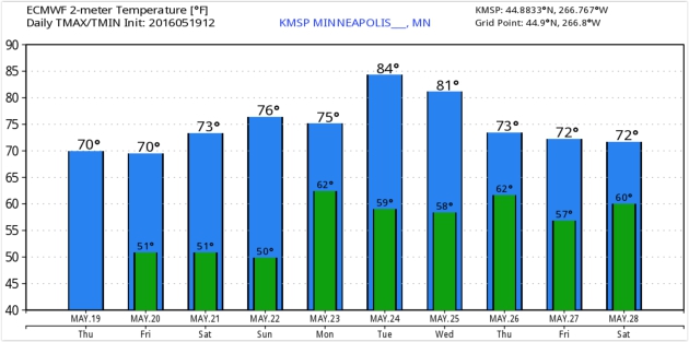
75 F. high in St. Cloud Thursday.
70 F. average high on May 19.
57 F. reported maximum temperature on May 19, 2015.
May 20, 1892:
Very late season snowfall hits central Minnesota. Maple Plain receives 4
inches of snow, with 3 inches falling in Minneapolis. This is the
latest significant snow on record for the Twin Cities, and one of the
latest widespread snowfalls in Minnesota.
May 20, 1876: A tornado touches down near Ft. Ripley.
 Forecast Calls for Blue-Ribbon A+ Weekend Weather
The
only predictable thing is change. That applies to the weather, and the
last time I checked there isn't a thing we can do about it. We try and
predict it but we'll never control it.
I've heard some of the
conspiracy theories about weather-weapons, but the amount of energy
required to alter weather on a large scale is staggering, beyond the
scope of any energy-source available today.
The weather is
impacted by volcanoes, water temperatures in the Pacific and rapid
warming of the Arctic, which may be affecting the speed and
configuration of the jet stream, worldwide.
Moisture from a
southern storm turned off the sun for a few hours yesterday (people were
indignant!) and more cumulus may sprout today, but the weekend still
looks phenomenal.
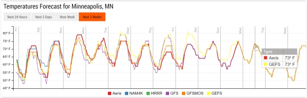
Saturday features blue sky and light winds. Stronger southerly winds may kick the mercury up to 80F
Sunday afternoon. Models pull a showery front into town
Monday; I'd bet a stale bagel the weekend after next will be much wetter.
GFS guidance from NOAA hints at a heat bubble by early June. Hazy, lazy, sticky days are on the way.
ECMWF Temperature Guidance.
The "Euro" hints at mid to upper 70s this weekend with peak warmth next
Tuesday before cooling off as another, more significant surge of
moisture approaches late next week. Graphic: WeatherBell.
Pushing 80F on Sunday.
NOAA's NDFD guidance shows 79F at 4 pm Sunday, which I think is more
than realistic, assuming sunshine, stiff south winds and no rain, all of
which appear to be good assumptions right now. I still think we'll see
some low 80s close to home by late afternoon Sunday. Source: Aeris
Enterprise.
Memorial Day Guess-Cast.
People are asking so I thought I'd walk the plank and oblige.
Long-range GFS guidance from NOAA suggests low 70s on Memorial Day. The
Dow will be up 33 points. Politicians will stay stupid stuff on TV.
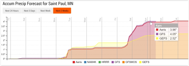
Swerving Back Into a Wet Pattern Next Week.
The graphic above shows predicted rainfall amounts between now and
Sunday, May 29 at 1 pm, courtesy of NOAA's GFS model. One band of
showers sweeps across Minnesota Monday, but a slower-moving, potentially
wetter storm arrives....wait for it....late next week into at least a
portion of Memorial Day weekend. But we could have predicted that months
ago. Source: AerisWeather.
Insert Deep, Mournful Sigh Here.
What's more fun than navigating construction zones during rush hour?
Commuting in the rain! Models print out showers and possible thunder
Monday, but a more potent southern storm arrives with heavier rain by
the end of next week. 3-4" amounts seem extreme right now - not quite
believing it yet, but it is a holiday weekend, and there will be payback
for all this glorious weather.
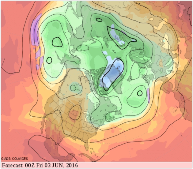
Heat Bubble by Early June?
Looking out roughly 2 weeks at predicted (GFS) 500 mb winds suggests a
high pressure ridge reestablishing over the Northern Plains and Upper
Midwest, which would imply a few 80s as we push into the first week of
June. We're due for a more sustained heat spike or two.
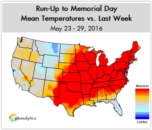
Warming Trend into Memorial Day. Here's an excerpt from a prediction by
Planalytics: "
Warmer conditions will encompass much of the country over the Memorial Day Weekend (Friday, May 27th – Monday, May 30th),
boding well for outdoor activities. Major population centers along the
Atlantic seaboard will continue to enjoy warmer temperatures vs. recent
weeks, supporting demand for summer consumables such as suncare, bottled
water, and bagged ice. Locations along the West Coast will see a shift
to warmer than normal temperatures over the weekend. The South Central,
Plains, and Upper Midwest are expected to see seasonal warmth..."
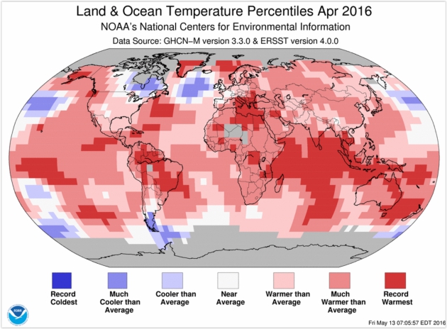
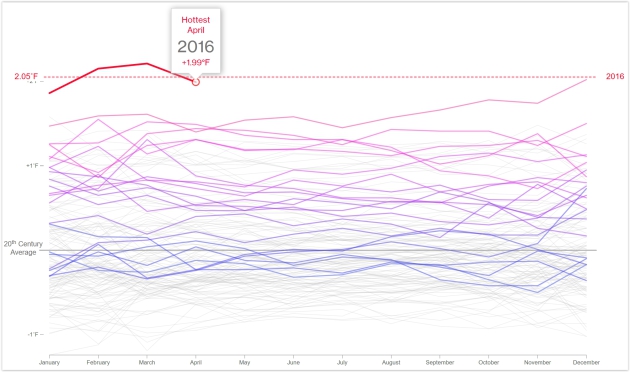
Highest Temperature Departure for April Since Records Began in 1880. Not my words but NOAA's. Here's an excerpt from a
recent summary: "...
The
combined average temperature over global land and ocean surfaces for
April 2016 was 1.10°C (1.98°F) above the 20th century average of 13.7°C
(56.7°F)—the highest temperature departure for April since global
records began in 1880. This value surpassed the previous record set in
2010 by 0.28°C (0.50°F). This was also the fourth highest monthly
temperature departure among all 1,636 months on record, behind March
2016 (1.23°C/2.21°F), February 2016 (1.19°C/2.14°F), and December 2015
(1.12°C/2.02°F). Overall, 13 out of the 15 highest monthly temperature departures in the record have all occurred since February 2015, with February 1998 and January 2007 among the 15 highest monthly temperature departures..."
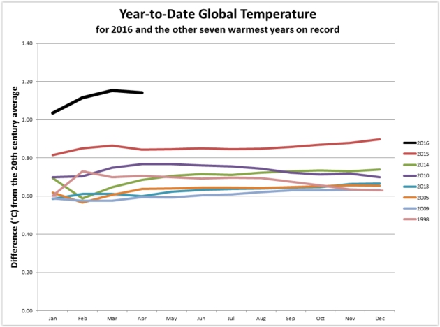
April 2016: Earth's 12th Consecutive Warmest Month on Record. Weather Underground's Jeff Masters and Bob Henson have a
very good post with more perspective, including the implications of a brewing La Nina cool phase: "...
If
we were to experience a similar drop in global temperature later this
year—which is possible if we transitioned to a moderate La Niña, as
predicted by several models—then the departure from average for the last
eight months of the year could be in the neighborhood of 1.02°C. In
that case, 2016 will still cruise handily to the title of warmest year
on record. The drop from Jan-Apr to May-Dec would need to be twice as
large this year as it was in 1998 in order to put this year’s annual
average below that of 2015. Small wonder, then, that NASA/GISS director
Gavin Schmidt has laid 99% odds on this year becoming the warmest in global records...."
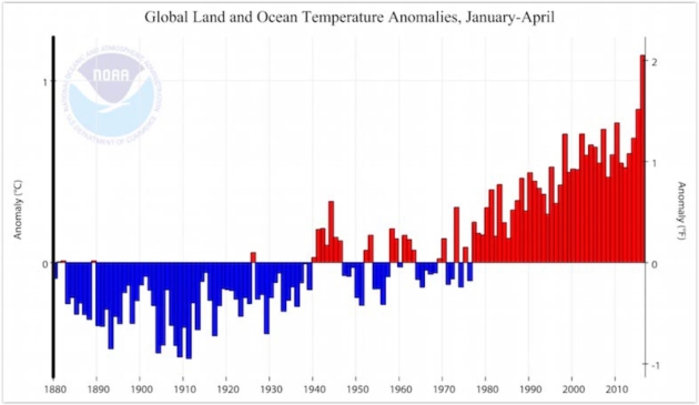
Image credit: "
Departure
from average for the global January-through-April temperature for the
years 1880 - 2016. This year has seen by far the warmest temperatures on
record for each of the four months." Image credit:
NOAA/National Centers for Environmental Information (NCEI).
Earth Has Now Seen an Unprecedented 12 Straight Months of Record Warmth. Andrew Freedman has ann update at
Mashable: "
Each
of the past 12 months has set a record for being the warmest such month
in 137 years of record-keeping, according to the National Oceanic and
Atmospheric Administration (NOAA). The agency released new data on
Wednesday finding that April also was the warmest such month on record
for the globe, creating the 12-months of consecutive warmth, which has
never happened before since instrumental records began in 1880. According
to NOAA, global average surface temperatures during April were 1.10
degrees Celsius, or 1.98 degrees Fahrenheit, above the 20th century
average, which was the most unusually mild April on record..."
Image credit: "Year-to-date global average temperatures compared to previous record warm years." Image: NOAA/NCEI.
Hurricane Hunters Pierce Heart of Storm With Skill. Here's a clip from a story at
The Houston Chronicle that caught my eye: "...
Once
they find the windless, dead center, Sr. Master Sgt. Jay Latham, the
loadmaster, loads a spring-loaded cannon with small tubes, known as
dropsonde, packed with instruments. Latham fires the tubes out the
bottom of the aircraft. Parachutes open and they drift away, taking
readings that are radioed to Bundy's instruments until they land in the
ocean, where the water destroys their electrical system. Going into the
jaws of a hurricane takes experience and teamwork. "It takes a very
experienced crew to make this work easily," Latham said. "It takes two
to three years before guys are up to speed."
Photo credit above:
Photo: Marie D. De Jesus, Staff. "Master
Sgt. Ed Scherzer shows how a spring-loaded cannon with small tubes and
packed with instruments, known as dropsonde, is dropped into a hurricane."
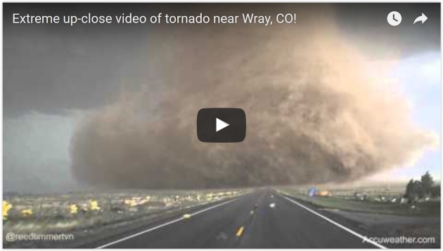
"More Will Die": The Ethics of Up-Close Tornado Chasing. Sadly, I have to agree with Jason Samenow at
The Capital Weather Gang: "
Daring storm
chasers have come perilously close to violent tornadoes this spring
while acquiring some of the most dramatic storm scenes ever filmed. But
the videos have raised important questions about how aggressive chasers
should be when they pursue these storms, whether for the thrill or for
research. How close is too close? Does “extreme” close-up video,
obtained and sold by chasers and shared by media for profit, encourage
copycat chasing that puts people’s lives at risk?..."
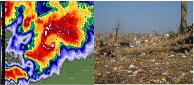
Facts and Figure From The Joplin Tornado: What Did It Cost? KSMU Radio has a good summary of that horrific day in Joplin nearly 5 years ago: "
The
facts of the story are all too familiar by now—especially to those who
lived through it. On Sunday May 22nd, 2011, the most devastating level
of tornado, an EF-5 packing winds of over 200 miles per hour, tore
through Joplin, Missouri. The ¾-mile-wide twister touched down at the
western city limits of Joplin, stayed on the ground clear across the
city for six miles, and continued another seven miles into the town of
Duquesne and into rural Jasper and Newton counties. 161 people lost
their lives that afternoon. Now, it’s been five years since the Joplin
tornado..."
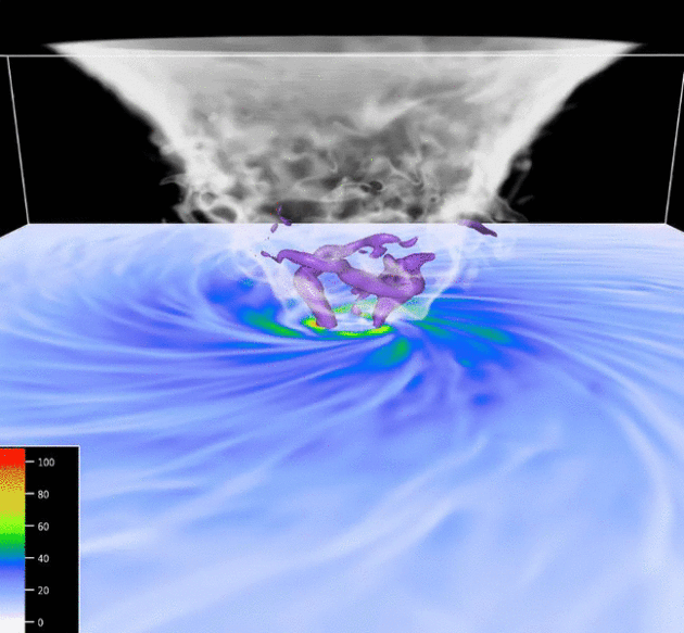
A 3-D Window Into a Tornado.
UCAR has a fascinating story and visualization - here's an excerpt: "...
Due
to the difficulties of measuring wind speeds in tornadoes, scientists
don't have answers to these questions. However, a collaborative project
between researchers at the University of Miami and NCAR has been seeking
clues with new, highly detailed computer simulations of tornado wind
fields. The simulations can be viewed in a series of animations,
created by NCAR scientist George Bryan, that provide a 3D window into
the evolving wind fields of idealized tornadoes at different rates of
rotation..."
Image credit: "
This simulation was
created by NCAR scientist George Bryan to visualize what goes on inside a
tornado. The animation is the "high swirl" version in a series that goes from low, to medium, to high. Click to enlarge." (
Courtesy Goerge Bryan, NCAR.
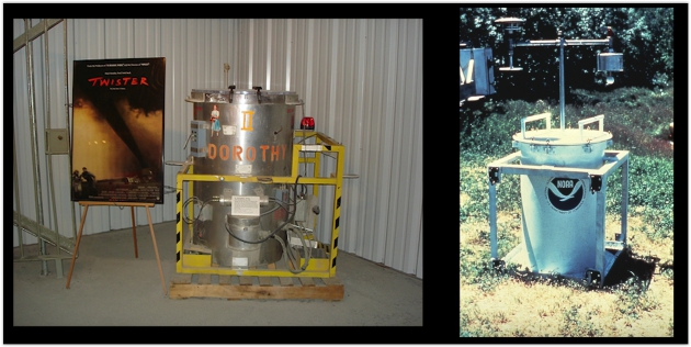
20th Anniversary of "Twister", the Movie. Weather World, a daily TV program produced by Penn State is seen across the state of Pennsylvania. Yesterday they ran a segment
on the anniversary of "Twister", including my small role with special
effects and my one (amazing!) line in the movie. Sadly, they also made
reference to my last royalty check from Warner Brothers. No, the film
career is not working out as planned.
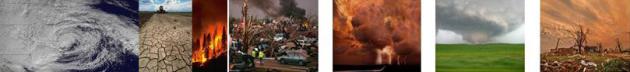
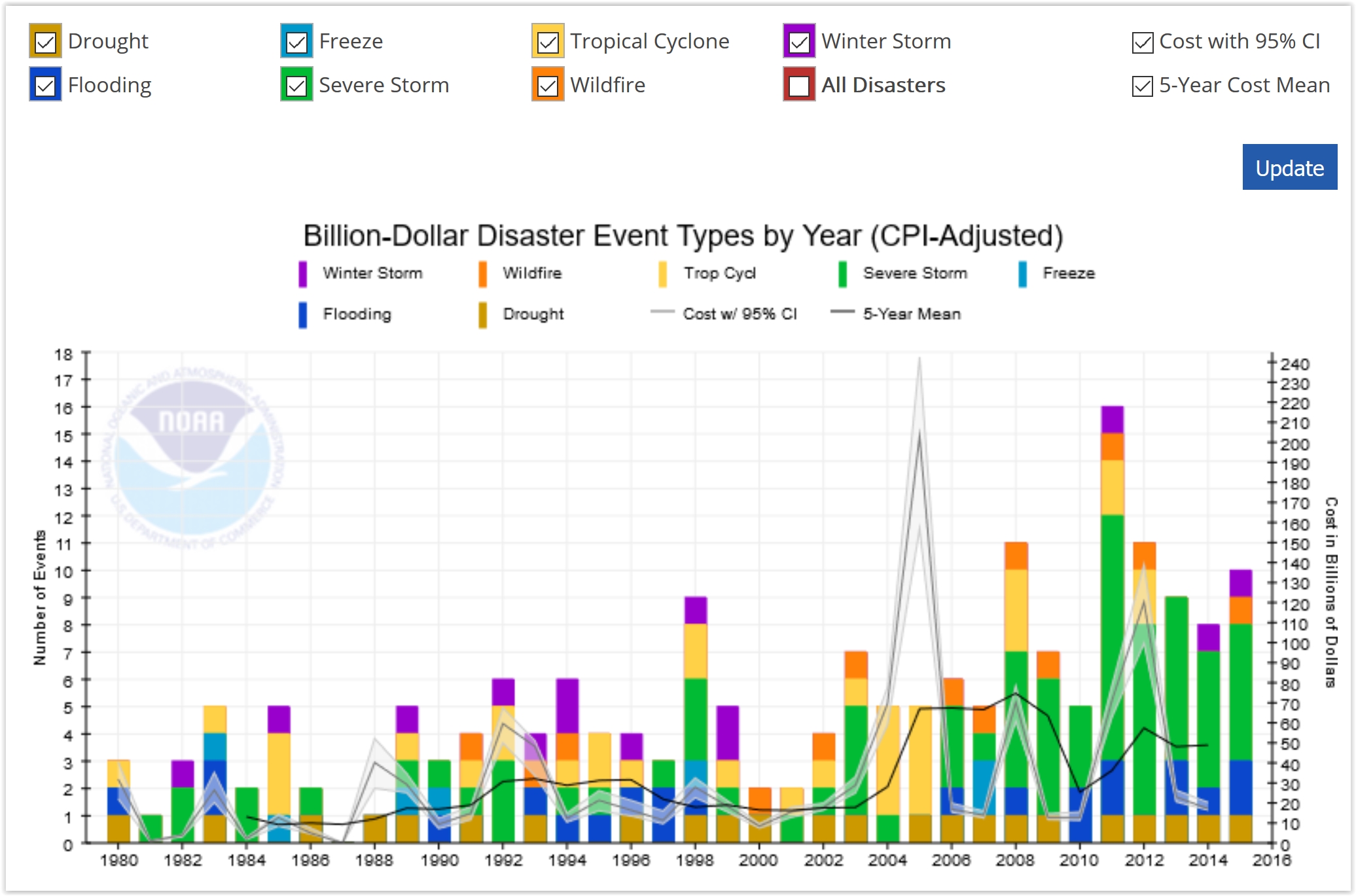 Billion Dollar U.S. Weather and Climate Disasters. Here's an excerpt from the National Centers for Environmental Information: "The
graphic below helps to visualize how the different types of identified
U.S. Billion-dollar disaster events have changed over time. Caution
should be used in interpreting any trends based on this graphic for a
variety of reasons. For example, inflation has affected our ability to
compare costs over time. To reflect this, the graphic also shows events
with less than $1 billion in damage at the time of the event, but after
adjusting for Consumer Price Index (inflation), now exceed $1 billion in
damages. Continued assessment of these data are in process, as there
are other factors as well that affect any rate of change interpretation.
Comparison of events in most recent years is most reliable
Billion Dollar U.S. Weather and Climate Disasters. Here's an excerpt from the National Centers for Environmental Information: "The
graphic below helps to visualize how the different types of identified
U.S. Billion-dollar disaster events have changed over time. Caution
should be used in interpreting any trends based on this graphic for a
variety of reasons. For example, inflation has affected our ability to
compare costs over time. To reflect this, the graphic also shows events
with less than $1 billion in damage at the time of the event, but after
adjusting for Consumer Price Index (inflation), now exceed $1 billion in
damages. Continued assessment of these data are in process, as there
are other factors as well that affect any rate of change interpretation.
Comparison of events in most recent years is most reliable..."
7 States With The Most Dangerous Weather.
I was surprised to see Nevada and Wyoming make the cut; the findings
for Alabama are skewed by a particularly violent series of tornado
outbreaks in 2011. Here's an excerpt from
24/7 Wall St: "...
While
geography and climate play a central role in dangerous weather, poverty
amplifies its negative effects. According to a report from the Centers
for Disease Control and Prevention, weather-related death rates are “2
to 7 times as high in low-income counties as in high-income counties.”
This is likely because those living below the poverty line to not have
the means to prepare for, or adapt to, extreme weather events and
conditions, according to the CDC. It is perhaps no coincidence that the
poverty rate is as high or higher than the 15.6% national rate in each
of the states on this list except for Wyoming..."
 Ebola Czar: America Failing on Zika
.
POLITICO has the story - here's the intro: "
The
man who led the successful White House response to the Ebola outbreak
says the Zika virus is a slow-motion public health disaster — and
Congress is to blame. Ron Klain, who served as White House Ebola czar
and as Vice President Joe Biden’s chief of staff, told POLITICO's “Pulse Check” podcast
that Congress has failed to heed the lessons of the Ebola epidemic and
that the Zika funding battle has become unforgivably partisan in the
face of such dire human costs, including severe brain defects in
infants..." (Image: Climate Nexus).
Is USA Falling Behind in Race to Prepare for Electromagnetic Pulse Attacks? Here's the intro to a story at Nextgov.com: "Electromagnetic
pulses and violent space weather outbursts might seem like national
security threats straight out of science fiction. But the House Homeland
Security Committee wants to ensure federal agencies are doing their
best to prepare for them. During an Oversight and Management Efficiency subcommittee hearing Tuesday,
legislators reviewed the possible ramifications that a man-made EMP
weapon, detonated nuclear device or even space weather phenomena could
have on the nation’s power grid. While seemingly remote, the threats
drew comparisons to the Japanese attack on Pearl Harbor in 1941 and the
Sept. 11 terrorist attacks..."
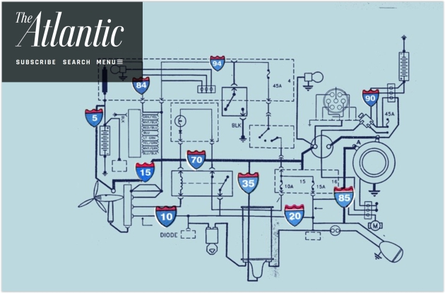
The Energy Interstate. Do we have the political will to build the energy equivalent of the U.S. interstate system? Here's a clip from
The Atlantic: "...
The
most recent high-profile paper making this argument was published in
January by researchers at the National Oceanic and Atmospheric
Administration and the University of Colorado at Boulder. Christopher
Clack and colleagues built a model to predict the long-term costs of
putting all kinds of energy into the electrical system. When they
imposed a constraint on their model—it couldn’t use coal—they found that
the cheapest option involved a grid of transmission lines that could
carry solar and wind energy from almost any part of the country to
anywhere else. Other technologies—perhaps Gates’s imagined miracle—would
still be required to get rid of carbon-emitting fuels altogether, but
the new grid would get us quite far, reducing emissions from power
plants by up to 80 percent within 15 years..." (Photo credit:
Justin Renteria).
 Storing The Sun's Energy Just Got a Whole Lot Cheaper. Joe Romm explains at ThinkProgress: "With prices dropping rapidly for both renewables and battery storage, the economics of decarbonizing the grid are changing faster than most policymakers, journalists, and others realize. So, as part of my ongoing series,
“Almost Everything You Know About Climate Change Solutions Is
Outdated,” I will highlight individual case studies of this real-time
revolution. My Monday post discussed the Federal Energy Regulatory Commission’s (FERC) report
that in the first quarter, the U.S. grid added 18 megawatts of new
natural gas generating capacity, but 1,291 MW of new renewables. But one
of FERC’s “Electric Generation Highlights” for March deserves special
attention as a leading indicator of the revolutionary new economics of
solar plus storage
Storing The Sun's Energy Just Got a Whole Lot Cheaper. Joe Romm explains at ThinkProgress: "With prices dropping rapidly for both renewables and battery storage, the economics of decarbonizing the grid are changing faster than most policymakers, journalists, and others realize. So, as part of my ongoing series,
“Almost Everything You Know About Climate Change Solutions Is
Outdated,” I will highlight individual case studies of this real-time
revolution. My Monday post discussed the Federal Energy Regulatory Commission’s (FERC) report
that in the first quarter, the U.S. grid added 18 megawatts of new
natural gas generating capacity, but 1,291 MW of new renewables. But one
of FERC’s “Electric Generation Highlights” for March deserves special
attention as a leading indicator of the revolutionary new economics of
solar plus storage.."
Photo credit: S&C Electric Company. "Part of a game-changing 4.2 MW solar + storage system in Minster, Ohio."
Google To Introduce Its Voice-Activated Home Device. I fear Google knows me better than I know myself. Now I can talk back to myself. Here's an excerpt from a
New York Times story: "
Google
will introduce its much-anticipated entry into the voice-activated home
device market on Wednesday, according to people who spoke on the
condition of anonymity. Named Google Home, the device is a virtual agent
that answers simple questions and carries out basic tasks. It is to be
announced at Google’s annual developers’ conference in Silicon Valley.
Google Home will come to market in the fall — a long time away, given
the speed of technology, but Google needed to plant a stake in the
ground now. The device will compete with Amazon’s Echo, which was introduced less than two years ago. Amazon has already sold an estimated three million units..."
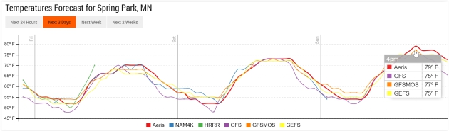
TODAY: More clouds than sun. Winds: SE 8-13. High: 70
FRIDAY NIGHT: Clearing and comfortably cool. Low: 53
SATURDAY: More sun, light winds. Perfect. Winds: SE 5-10. High: 76
SUNDAY: Warm sun, stronger winds kick in. Winds: S 10-20. Wake-up: 58. High: 81
MONDAY: Few showers, possible thunder. Winds: SW 10-20. Wake-up: 62. High: 76
TUESDAY: Partly sunny, late-day thunder? Winds: S 8-13. Wake-up: 59. High: near 80
WEDNESDAY: More widespread showers, storms- some heavy. Winds: E 10-15. Wake-up: 60. High: 77
THURSDAY: Showers linger, still soggy. Winds: N 8-13. Wake-up: 61. High: 76
Climate Stories...
Earth's Relentless Warming Just Hit a Terrible New Threshold. Here's the introduction to a story at
Bloomberg: "
The
number of climate records broken in the last few years is stunning. But
here's a new measure of misery: Not only did we just experience the
hottest April in 137 years of record keeping, but it was the 12th
consecutive month to set a new record. It's been relentless. May 2015
was the hottest May in records dating back to 1880. That was followed by
the hottest June. Then came a record July, August, September, October,
November, December, January, February, March—and, we learned from the
National Oceanic and Atmospheric Administration on Wednesday—the hottest
April. In an age of rising temperatures, monthly heat records have
become all too common. Still, a string of 12 of them is without
precedent..."
Graphic credit: GHCN-M & ICOADS Data Sets Provided by NOAA. GRAPHIC: Blacki Migliozzi
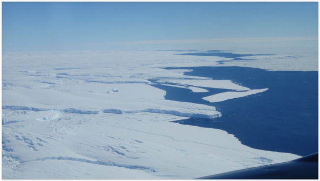
"Fundamentally Unstable": Scientists Confirm Their Fears About East Antarctica's Biggest Glacier. Chris Mooney has the story at
The Washington Post: "
Scientists
ringing alarm bells about the melting of Antarctica have focused most
of their attention, so far, on the smaller West Antarctic ice sheet,
which is grounded deep below sea level and highly exposed to the
influence of warming seas. But new research published
in the journal Nature Wednesday reaffirms that there’s a possibly even
bigger — if slower moving — threat in the much larger ice mass of East
Antarctica. The Totten Glacier holds back more ice than any other in
East Antarctica, which is itself the biggest ice mass in the world by
far..."
Photo credit: "
Aerial photo of Totten Glacier’s ice shelf edge." (Jamin Greenbaum)
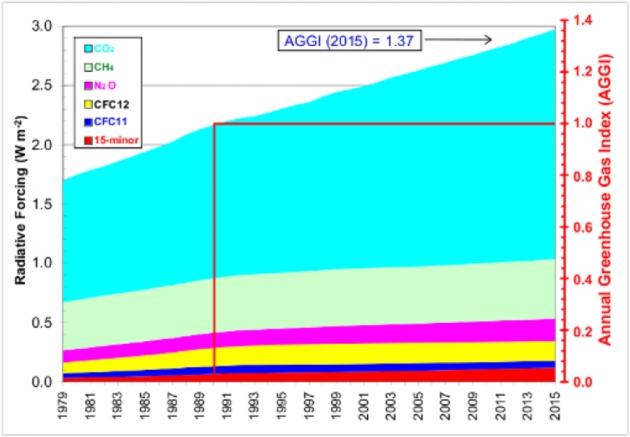
NOAA: Global Warming Effect of Emissions Up 37 Percent Since 1990. Here's an excerpt from
Colarado Public Radio: "
The
warming effect of greenhouse gases got a little bigger last year,
according to new data from the National Oceanic and Atmospheric
Administration. And unfortunately for us, it's gotten a little bit
bigger each year for awhile now. The latest installment of NOAA's Annual
Greenhouse Gas Index shows an increase of 37 percent since 1990..." (Graphic credit: NOAA).
If You Care About Kids, You Care About Climate.
NRDC.com takes a look at a new study - here's a story excerpt: "...
Regardless
of what else we may believe in, we all can get behind making the world a
better place for our children. The wish to see them grow and prosper in
a safe, stable, and healthy environment transcends ideology or
political partisanship. I’ve come to understand what all parents come to
understand: Having kids really does change the way you think about the
world, and especially about where we’re all headed. To take
responsibility for a child’s life is to take responsibility for that
child’s present—and future—environment. A new report underscores the
staggering importance of that responsibility and also provides a
scorecard as to how seriously we’ve been taking it. In doing so, Children and Climate Change, which was copublished by Princeton University and the Brookings Institution..."
Climate Changes to Mean Canada to Spend More on Disasters: Insurers.
Reuters has the article; here's an excerpt that caught my eye: "...
Climate change ... has moved from future threat to present danger." The Insurance Bureau represents more than 90 per cent of all car, home and business insurers in Canada. Forgeron
said the world had entered a troubling new era in which natural
disasters such as fires and floods were happening more frequently. Ways to help mitigate the damage include taking steps to better identify risks and then manage them.
"This means limiting or ending the practice of building in areas deemed
high risk by flood mapping and having a hard discussion about where to
build in areas that are close to our boreal forests," he said..."
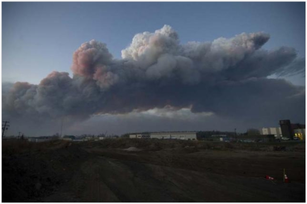
Photo credit above: "A
massive plume of smoke, from a wildfire north of the city, stretches
over Fort McMurray, Alberta, Canada Wednesday evening, May 5, 2016." Courtesy Chris Schwarz/Government of Alberta/Handout via Reuters
Scientists, Investors Seek to Identify Financial Risks of Climate Change. Here's a clip from
Reuters: "
A
Norwegian group of climate scientists will form an alliance on Thursday
with investors including BlackRock Inc and the World Bank to try to
assess the financial risks of rising global temperatures.
The Center for International Climate and Environmental Research, Oslo
(CICERO) said it wanted to help investors judge risks from global
warming such as more heatwaves, floods, downpours, the extinction of
animals and plants and rising seas.
The head of CICERO, Kristin Halvorsen, said the aim was to help
investors and researchers to "understand each other more easily so that
the financial sector can define climate risks"...
The
warming effect of greenhouse gases got a little bit bigger last year,
according to new data from National Oceanic and Atmospheric
Administration. And unfortunately for us, it's gotten a little bit
bigger each year for awhile now. The latest installment of NOAA's Annual
Greenhouse Gas Index shows an increase of 37 percent since 1990.
- See more at: http://www.cpr.org/news/newsbeat/noaa-global-warming-effect-emissions-37-percent-1990#sthash.ZZrufp6O.dpuf
 Climate Change Puts 1.3 Billion People and $158 Trillion at Risk, World Bank Says. The Guardian
 reports; here's the intro: "
The
global community is badly prepared for a rapid increase in climate
change-related natural disasters that by 2050 will put 1.3 billion
people at risk, according to the World Bank.
Urging better planning of cities before it was too late, a report
published on Monday from a Bank-run body that focuses on disaster
mitigation, said assets worth $158tn – double the total annual output of
the global economy – would be in jeopardy by 2050 without preventative
action. The Global Facility for Disaster Reduction and Recovery said
total damages from disasters had ballooned in recent decades but warned
that worse could be in store as a result of a combination of global
warming, an expanding population and the vulnerability of people crammed
into slums in low-lying, fast-growing cities that are already
overcrowded..."
Rising Seas Levels Made This Republican Mayor a Climate Change Believer.
As I tell people, I don't believe the science, I test the science. And
every time I test theory with actual observations it confirms that the
atmosphere and oceans are warming; the symptoms becoming harder to
dismiss or deny over time. Here's an excerpt from
NPR: "
A
man moves to a city in Florida and decides he wants to be mayor. He
wins the election. He's happy. Then he's told his city is slowly going
underwater. Not financially. Literally. James Cason
had settled in Coral Gables, a seaside town near Miami, six years ago.
He ran for mayor on the Republican ticket and, soon after he won, heard
the lecture by scientists about sea level rise and South Florida that
left him flabbergasted. "You know, I'd read some articles here and
there," he recalls, "but I didn't realize how impactful it would be on
the city that I'm now the leader of..."
Photo credit: "
The
mayor of Coral Gables, Fla., worries that the continued rise in sea
levels could sink the property values of waterfront neighborhoods."
PictureWendy/Flickr.
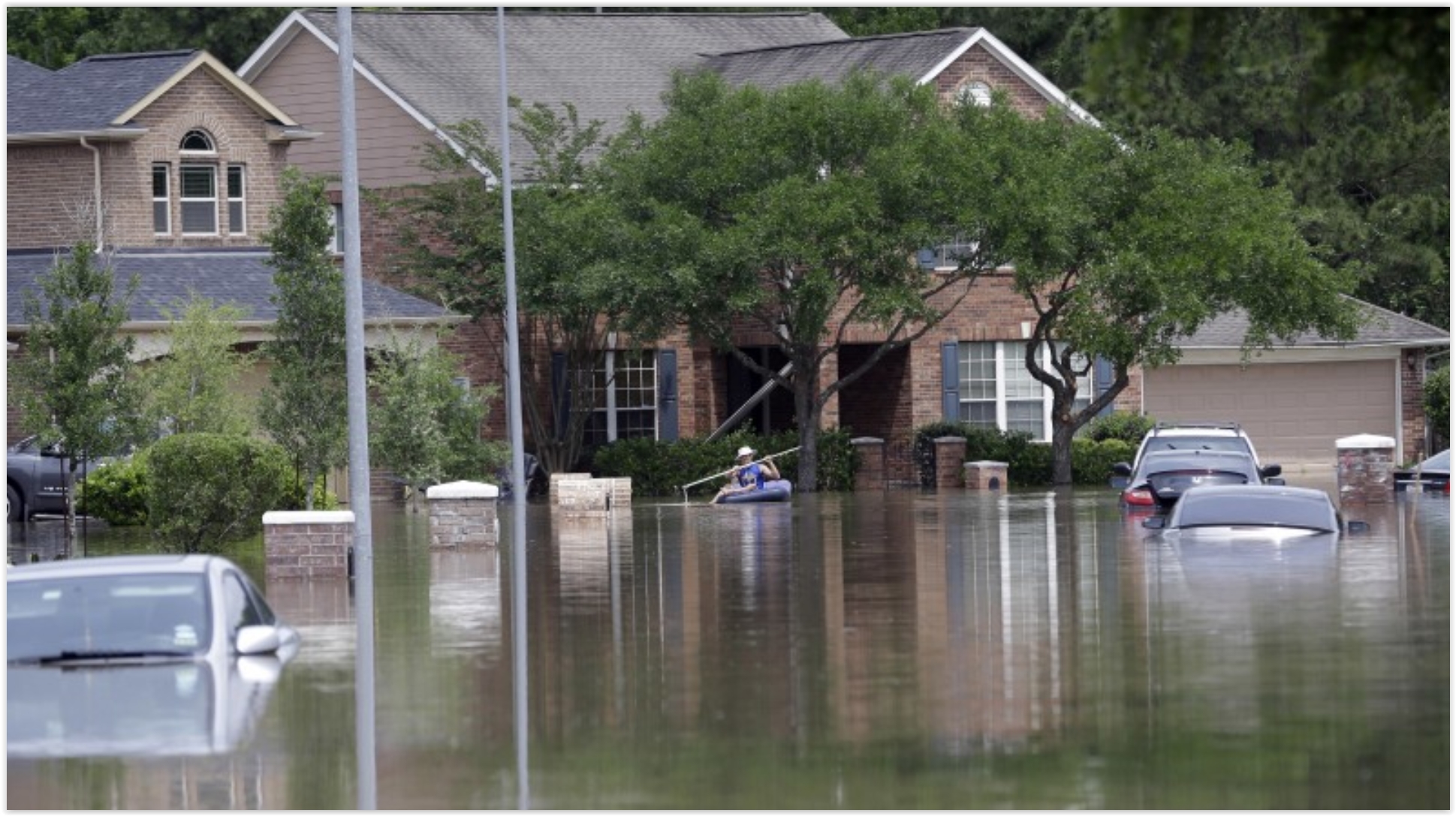
Climate Change, Runaway Development Worsen Houston Floods.
The tempo and severity of flash flooding and river flooding in Texas is
increasing - odds are it's not a coincidence, based on a variety of
factors. Here's an excerpt from ABC News: "...Extreme
downpours have doubled in frequency over the past three decades,
climatologists say, in part because of global warming. The other main
culprit is unrestrained development in the only major U.S. city without
zoning rules. That combination means more pavement and deeper
floodwaters. Critics blame cozy relations between developers and local
leaders for inadequate flood-protection measures. An Associated Press
analysis of government data found that if Harris County, which includes
Houston, were a state it would rank in the top five or six in every
category of repeat federal flood losses — defined as any property with
two or more losses in a 10-year period amounting to at least $1,000 each..."
File photo above:
Texas Monthly. "
A
person paddles through a flooded neighborhood, Tuesday, April 19,
2016, in Spring Texas. Storms have dumped more than a foot of rain in
the Houston area, flooding dozens of neighborhoods." AP Photo - David J. Phillip.


No comments:
Post a Comment