Minnesota Crop Update
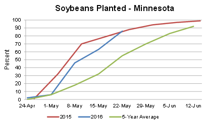
The
latest crop progress update for Minnesota was released Monday from the
USDA, showing that the recent frost didn't have much of an impact on the
corn crop. 78% of the corn statewide has emerged, and 65% of that is in
good to excellent condition. Meanwhile, 86% of the soybean crop is
planted. Read more from the USDA.
______________________________
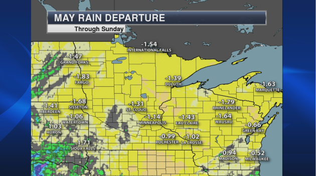
Minnesota May Rain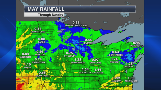
This May is starting off as one of the driest on record for some areas of the upper Midwest. In Fargo, the 0.08" of rain they received through the first 22 days of May was the third driest start to the month on record (the driest was 0.04" in 1980). The 0.38" received through Sunday in International Falls ranks it as the sixth driest start to May on record (driest: 0.07" in 1917).
______________________________
Do You Have a Severe Storm Action Plan?
By: Paul Douglas
By: Paul Douglas
'Tis the season for outdoor weddings and grad parties. Do yourself a big favor: RENT THE TENT. It's always good to have a Plan B, especially in June, the wettest, most severe month of the year in Minnesota.
A NOAA Weather Radio works great at home or the office, but when you're mobile how do know when violent weather is approaching? Put that shiny supercomputer in your pocket (smartphone) to good use. There are now apps that send warnings directly to your phone, based on your GPS-location.
Review an action plan with your family. "Where would you go if this was the real deal?" A little paranoia goes a long way.
We will be in a volatile, tropical pattern into next week with numerous showers & T-storms. No major severe outbreak is imminent, but models print out 2-3 inches of rain by Memorial Day.
Wednesday and Saturday look like the wettest days; with light steering winds aloft storms may linger, increasing the risk of isolated flash flooding. Throw in orange construction cones and you have a party on the freeway!
Take it easy out there; the thundery days of summer are here.
______________________________
Extended Forecast
TUESDAY: Warm sun, drier. High: 83. Low: 65. Chance of precipitation: 10%. Wind: W 3-8 mph.
WEDNESDAY: More showers and T-storms. High: 75. Low: 63. Chance of precipitation: 80%. Wind: SE 10-20 mph.
THURSDAY: Another break, intervals of sun. High: 80. Low: 63. Chance of precipitation: 20%. Wind: W 10-15 mph.
FRIDAY: Unsettled & sticky, few T-storms. High: 77. Low: 62. Chance of precipitation: 50%. Wind: S 10-15 mph.
SATURDAY: Wettest day of the holiday weekend. High: 76. Low: 63. Chance of precipitation: 90%. Wind: S 10-15 mph.
SUNDAY: Some sun, instability T-storm. High: 80. Low: 63. Chance of precipitation: 40%. Wind: SW 8-13 mph.
MONDAY: Probably the sunniest, driest day. High: 83. Low: 64. Chance of precipitation: 20%. Wind: W 7-12 mph.
______________________________
This Day in Weather History
May 24th
1925: After seeing a high of 99 degrees two days earlier, the Twin Cities picks up a tenth (.10) of an inch of snow.
1908: Tornadoes hit the counties of Martin and Blue Earth.
Minnesota Weather Outlook
This Day in Weather History
May 24th
1925: After seeing a high of 99 degrees two days earlier, the Twin Cities picks up a tenth (.10) of an inch of snow.
1908: Tornadoes hit the counties of Martin and Blue Earth.
______________________________
Average Temperatures & Precipitation for Minneapolis
May 24th
Average High: 72F (Record: 95F set in 2010)
Average Low: 51F (Record: 32F set in 1925)
Average Precipitation: 0.11" (Record: 2.58" set in 2012)
Average Snowfall: 0.0" (Record: 0.1" in 1925)
______________________________
Sunrise/Sunset Times for Minneapolis
May 24thSunrise: 5:35 AM
Sunset: 8:46 PM
*Length Of Day: 15 hours, 10 minutes and 51 seconds
*Daylight Gained Since Yesterday: ~1 mins & 53 secs
*Next Sunrise That Is Before 5:30 AM: June 1st (5:29 AM)
*Next Sunset That Is After 9 PM: June 13th (9:01 pm)
______________________________
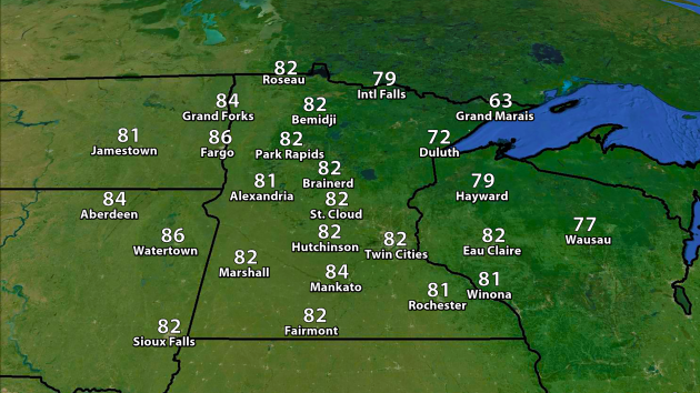
Highs
will climb into the 80s once again Tuesday across most of Minnesota
under mainly sunny skies. The coolest spots across the state will be
across northern Minnesota, particularly along and near Lake Superior.
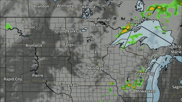
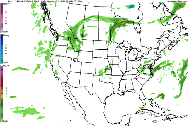
NAM forecast clouds and precipitation every three hours from 7 am Tuesday through 7 am Wednesday.
Clouds
will clear out as we head through the morning hours Tuesday, leading to
another warm and spectacular day across the region. A few storms are
possible across northern Minnesota heading into the evening hours.
Across southern Minnesota, we'll be watching storms moving into the
region as we head toward the Wednesday morning hours.
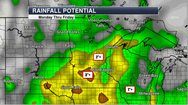
Of
course, the main story this week across Minnesota will be heavy
rainfall. One of our models - the GFS - is forecasting a good 2-3" of
rain through Friday as moisture streams in from the south. Even though
we will see a break in the rain Tuesday, another batch of heavy rain
will move in for Wednesday. That's certainly not the end of it, though -
while some scattered showers/storms will be around Thursday, another
storm system will move in for Friday into Saturday with the potential of
more heavy rain.
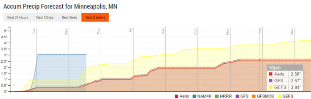
Looking
at a few of our extended models, there will be the potential of 2-4" of
rain across the Twin Cities by the time we get through Memorial Day.
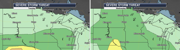
The
chance of storms will also bring a marginal threat of severe weather
both Tuesday and Wednesday across portions of the state. The marginal
threat is highlighted in the dark green area in the graphic above -
Tuesday over southern Minnesota (during the overnight hours) and
Wednesday across much of the state.
______________________________
National Forecast Outlook
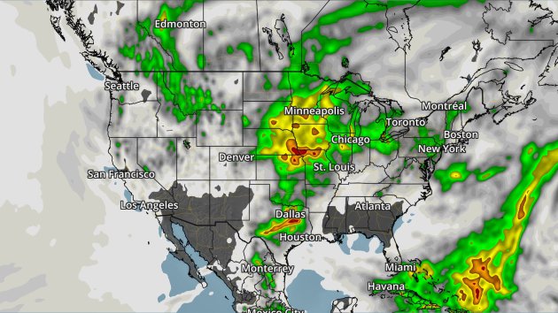
Rainfall potential through Friday. Green = 1"+, yellow = 2"+, orange = 3"+, red = 4"+.
The
upper Midwest, along with parts of the south, will be the target for
the heaviest of rain through Friday across the nation. 2-4"+ of rain
could fall in areas near Omaha, Kansas City and Dallas as we head toward
the Memorial Day weekend.
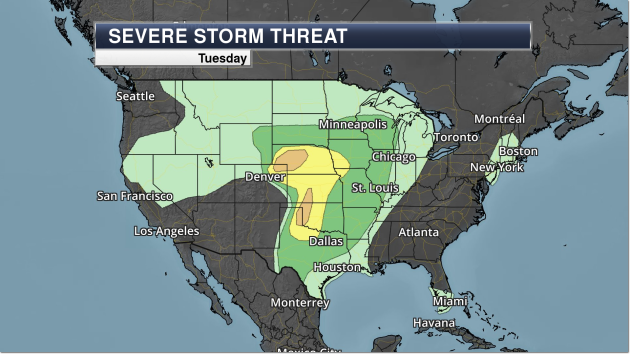
Another
afternoon and evening of severe weather is expected Tuesday with a
couple areas of the central U.S. that the Storm Prediction Center says
has an Enhanced threat of severe storms (in orange). The main threat
from these storms will be very large hail, but damaging winds and a few
tornadoes are possible as well.
______________________________
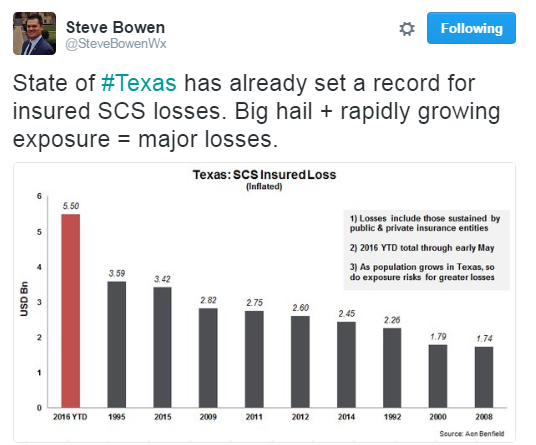
SCS = Severe Convective Storms.
______________________________
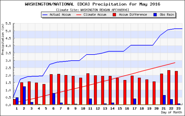
"D.C.’s worst May ever" - That's how Jason Samenow of the Capital Weather Gang describes the weather in the D.C. area so far this May. Read more: "So
far this May, D.C. has had a record number of rainy days (19 of 23) and
the coolest high temperatures since 1882. This May’s afternoon highs
are running an incredible 15 degrees cooler than last May’s. And we
still haven’t hit 80 degrees." (Graphic: Iowa Environmental Mesonet)
______________________________

From Time.com: Head distiller Caley Shoemaker is pictured a the Hangar 1 distillery on Alameda, named for a building on the old naval air base where it was founded. Credit: Sam Kweskin
Vodka... from Fog? Now here's a new one: a distillery in the San Francisco Bay Area is now making vodka from fog. More from Time: "Vodka
can be made from almost anything and often is. There’s potato-based
vodka. Wheat-based vodka. Grape-based vodka. There’s even vodka made
from milk and honey. But Bay Area-based Hangar 1 distillery has taken
this potable art to a level of elaborate novelty that makes $4 pieces of
toast boring by comparison: their team has produced a limited-edition
batch of vodka made from actual San Francisco fog."
______________________________
Thanks for checking in and have a great Tuesday! Don't forget you can follow me on Twitter (@dkayserwx) or on Facebook (Meteorologist D.J. Kayser)!
- D.J. Kayser

- D.J. Kayser
No comments:
Post a Comment