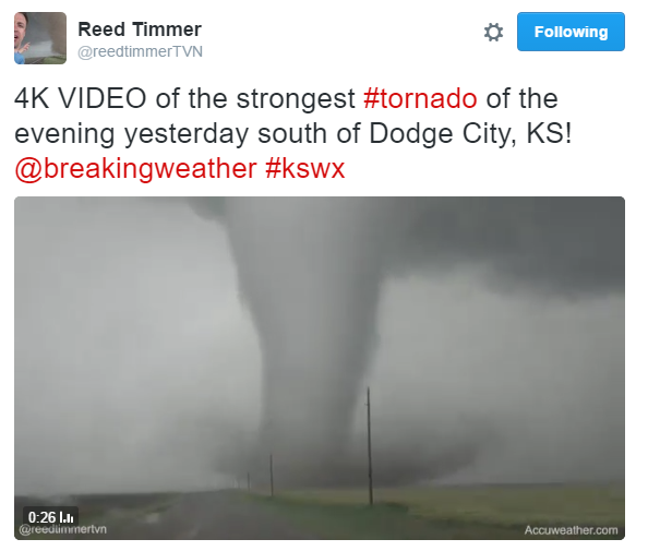
Tuesday featured a very strong and photogenic tornado near Dodge City, KS. This particular tornado got a lot of air time and was featured on many websites and news organizations. Take a look at the video link below from Reed Timmer @reedtimmerTVN.
See more from @reedtimmerTVN HERE:
See more from @reedtimmerTVN HERE:
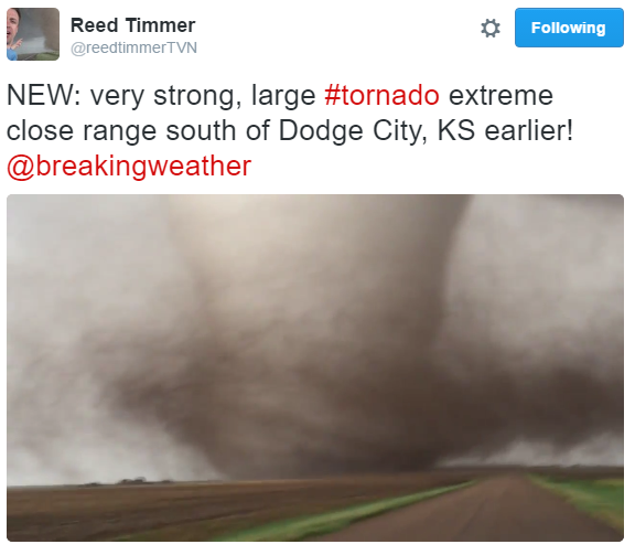
Dodge City, KS Tornado
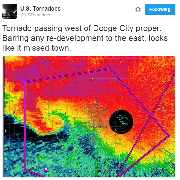
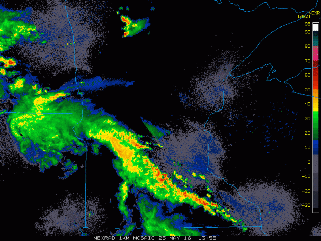
Thanks to @USTornadoes for the radar grab below. Note the "hook" on the left edge of the screen. This is what a tornado look like on radar. This particular tornado passed eerily close the the Dodge City, KS National Weather Service radar (black circle).
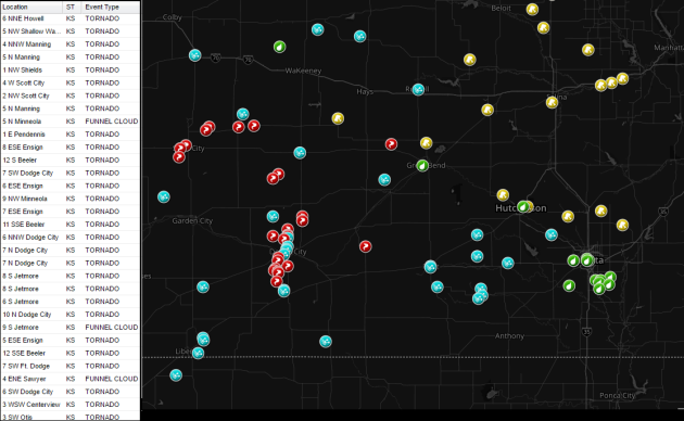
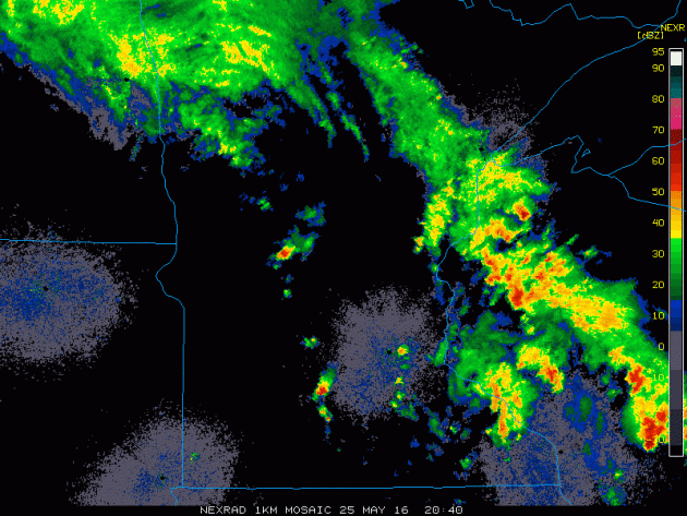
Storm Reports Tuesday
There were several severe weather reports across Kansas, but note all the tornado reports (red dots). According to the Storm Prediction Center, there were 30 tornado report across the country, most of which occurred in Kansas.
________________________
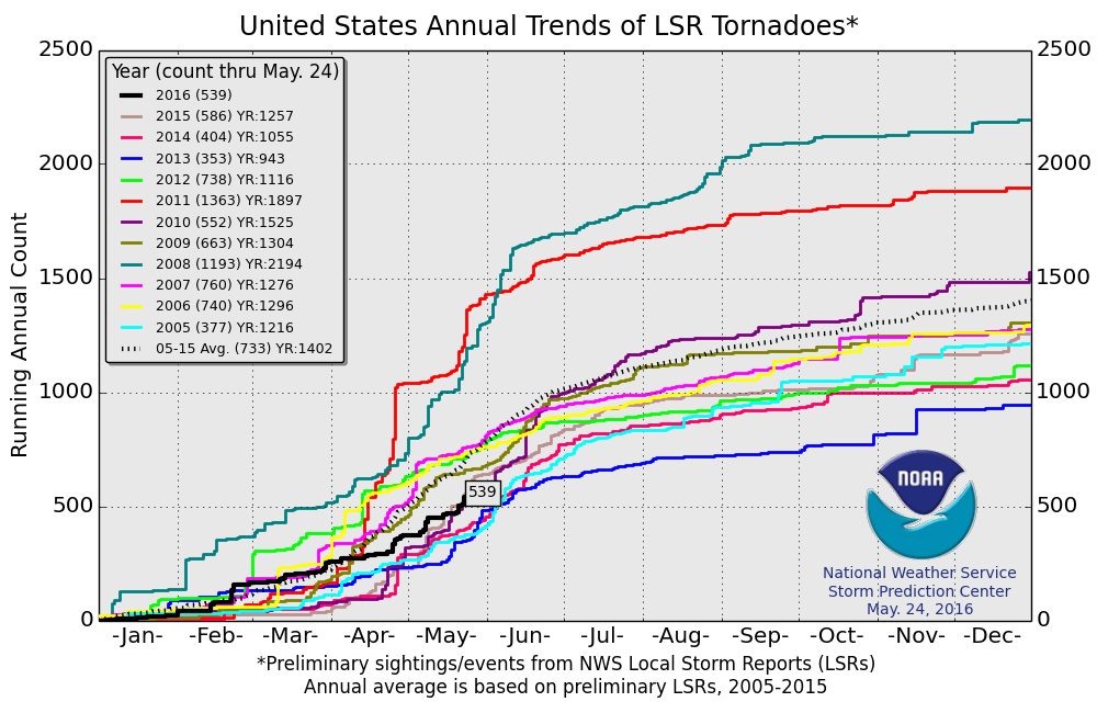
PRELIMINARY Tornado Count for 2016
According to NOAA's SPC, the PRELIMINARY 2016 tornado count (thru May 24) is 539. Note that the 2005 to 2015 average is 733.
Wednesday Morning Storms
Wednesday
featured a could of round of storms across parts of the state. Here was
the morning round that brought a few rumbles of thunder and heavy
downpours, but nothing severe.
Wednesday Afternoon Storms
The
second round of storms was a little widespread, but it came in the form
of a few individual cells that dropped hail and even spawned a tornado
warning NW of St. Cloud.
Severe Weather Awareness When You're Camping
By Paul Douglas
All this week we've been reviewing severe storms and situational awareness. A shelter (home, office, store) offers considerable protection - but what happens when you're in the woods, surrounded by flashing lightning and trees swaying ominously?
I rely on smartphone apps that key in on my GPS location. I also have an escape route when thunderstorms are approaching. Worst case: a mad dash to my vehicle, which offers some protection. Otherwise I would get out of my tent and seek shelter in a service building or restroom. Stating the obvious: you don't want to stand under a tree during an electrical storm.
Skies brighten Thursday, a brief break before the next swirl of showers and T-storms arrives Friday into Saturday. Have a Plan B (indoors) for Saturday, but models hint at some sun on Sunday with low 80s. ECMWF guidance brings in more T-storms on Memorial Day.
Unlike a March storm I don't expect an all-day rain event, but there will be storms around town the next few days.
Swarms of storms, an invasion of bugs, dew points up in the "oh-zone"? Sounds like a holiday to me.
___________________
Extended Outlook
WEDNESDAY NIGHT: Mostly cloudy with a few passing storms. Low: 62. Winds: SSE 5mph
THURSDAY: Damp start, then some sticky sun. High: 84. Wind: SW 8-13 mph.
THURSDAY NIGHT: Increasing clouds with a showers and storms possible late. Low: 65. Winds: WSW 5.
FRIDAY: More T-storms with locally heavy rain. High: 80. Wind: S 10-15 mph.
SATURDAY: Wettest day, numerous T-storms. Wake-up: 65. High: 76. Wind: S 8-13 mph.
SUNDAY: Best day? Sticky sun. Lake worth. Wake-up: 64. High: 83. Wind: W 8-13 mph.
MEMORIAL DAY MONDAY: Some sun. Watch for late day storms. Wake-up: 64. High: 83. Wind: W 7-12 mph.
TUESDAY: What a sock: more t-storms. Sticky. Wake-up: 65. High: 80. Winds: SE 8-13mph.
WEDNESDAY: Wet start, then slow clearing. Wake-up: 64. High: 77. Winds: NW 10-20mph
____________________________
This Day in Weather History
May 26th
1929: A tornado rakes Freeborn County and causes 10,000 dollars of damage to farms.
____________________________
Average High/Low for Minneapolis
May 26th
Average High: 72F (Record: 96F set in 1978)
Average Low: 52F (Record: 34F set in 1992)
_____________________________
Sunrise/Sunset Times for Minneapolis
May 26th
Sunrise: 5:33am
Sunset: 8:47pm
*Daylight Gained Since Yesterday: ~1min and 44secs
*Daylight Gained Since Winter Solstice: ~6hours and 28mins
*Note that we will gain an additional ~23mins of daylight by Summer Solstice (June 20th)
_______________________________
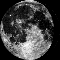
Moon Phase for May 26th at Midnight
3.2 days before last quarter
Extended Weather Outlook
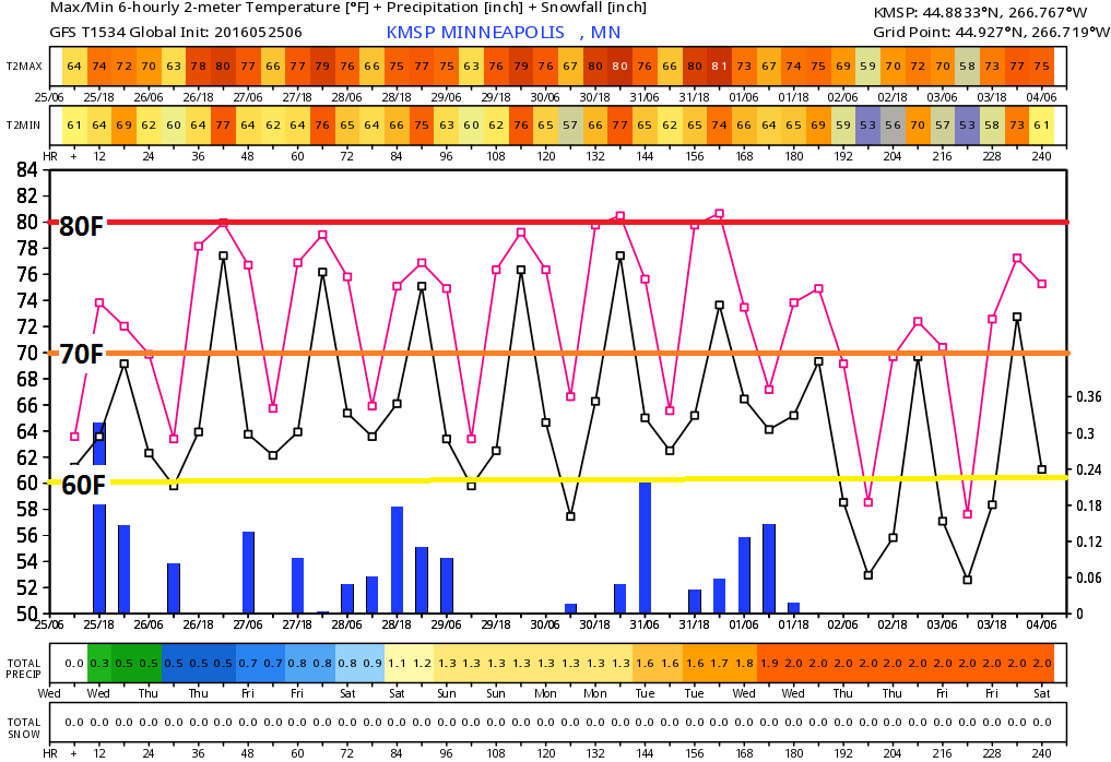
No doubt summer stickies have arrived. With high temperatures in upper 70s and 80s with a dew point in the upper 50s and 60s, this is almost too hot by Minnesota Standards. The extended forecast continues to keep temperature readings in that range through what appears to be the end of May/early June.
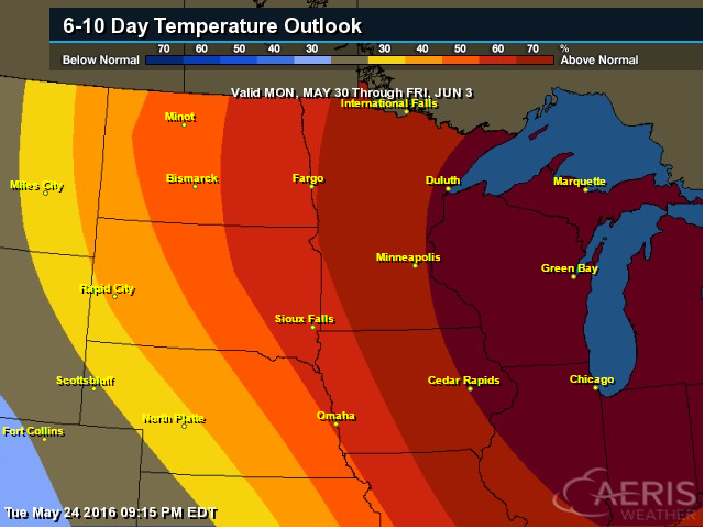
6 to 10 Day Temperatures Outlook
According to NOAA's CPC, the 6 to 10 day temperature outlook suggests that there is a good chance of warmer than average temperatures continuing from May 30th to June 3rd.
Thursday Weather Outlook
Thursday looks like one of the warmest days of the year thus far with highs approaching the mid/upper 80s across the southern half of the state. Dewpoints will once again be in the mid to upper 50s, so it'll be a little muggy, but not unbearable.
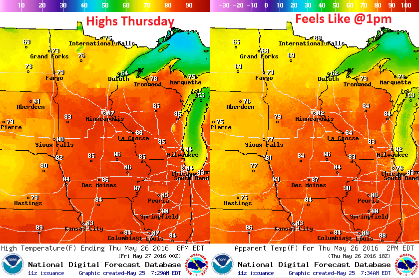
Thursday Weather Outlook
For the most part, Thursday looks like a dry day with some sunshine, but there may be a few late day storm that pop up with as much heat and humidity as there will be around the area.
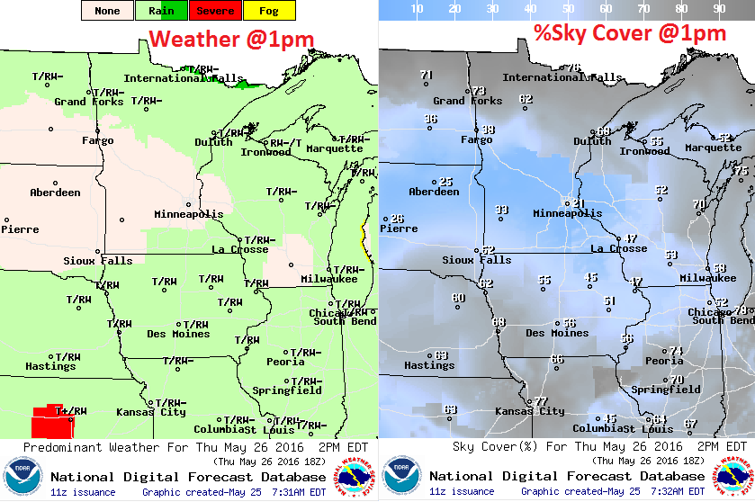
Thursday Weather Outlook
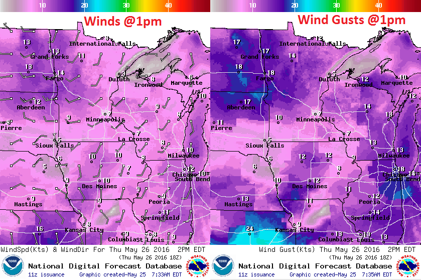
The impulse of energy that worked through the region yesterday responsible for sparking showers and storms across the region will lift into Canada Thursday. The winds on the southern flank of this low pressure system will be out of the WSW and may be a little breezy across NW Minnesota.
__________________________________
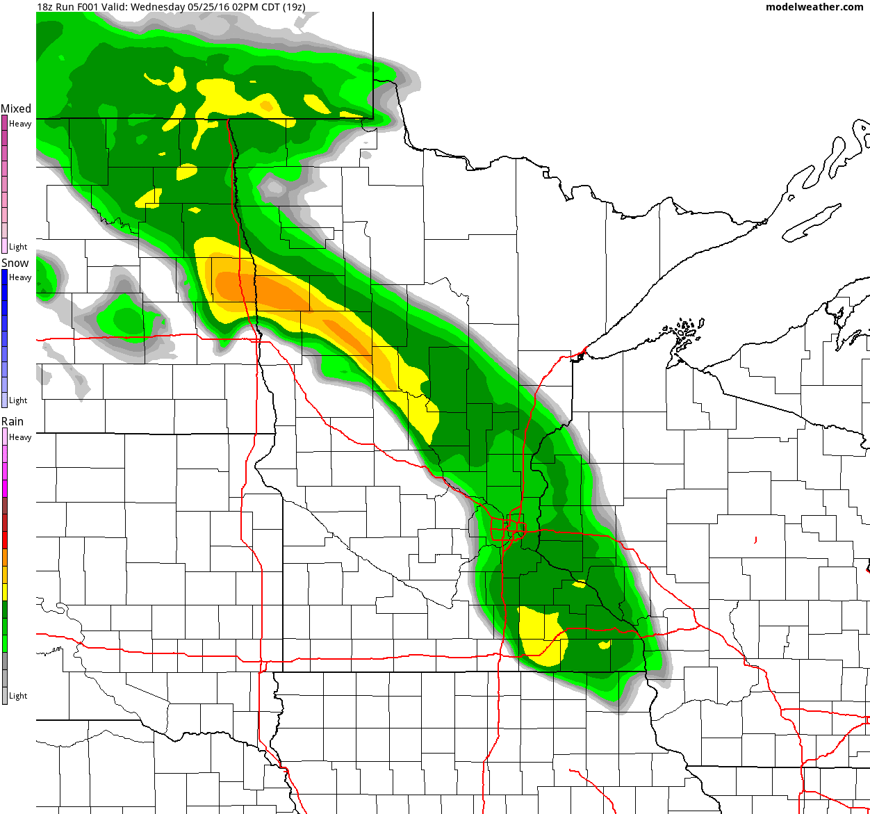
Simulated Radar
The simulated radar from midday Wednesday to Friday night shows heavier rainfall exiting the region on PM Wednesday to somewhat quieter weather returning on Thursday. However, with as warm and sticky as it'll be later this week, spotty showers and storms can't be ruled out. The next "bigger" wave and showers and storms looks to arrive late Friday into Saturday.
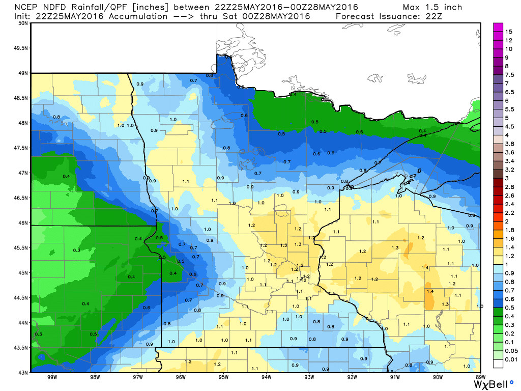
Rainfall Potential Thru 7pm Saturday
Rainfall potential through 7pm Saturday still looks fairly impressive with widespread 1"+ amounts across parts of Minnesota and Wisconsin. Keep in mind that most of this rain looks to slide through PM Friday through Saturday.
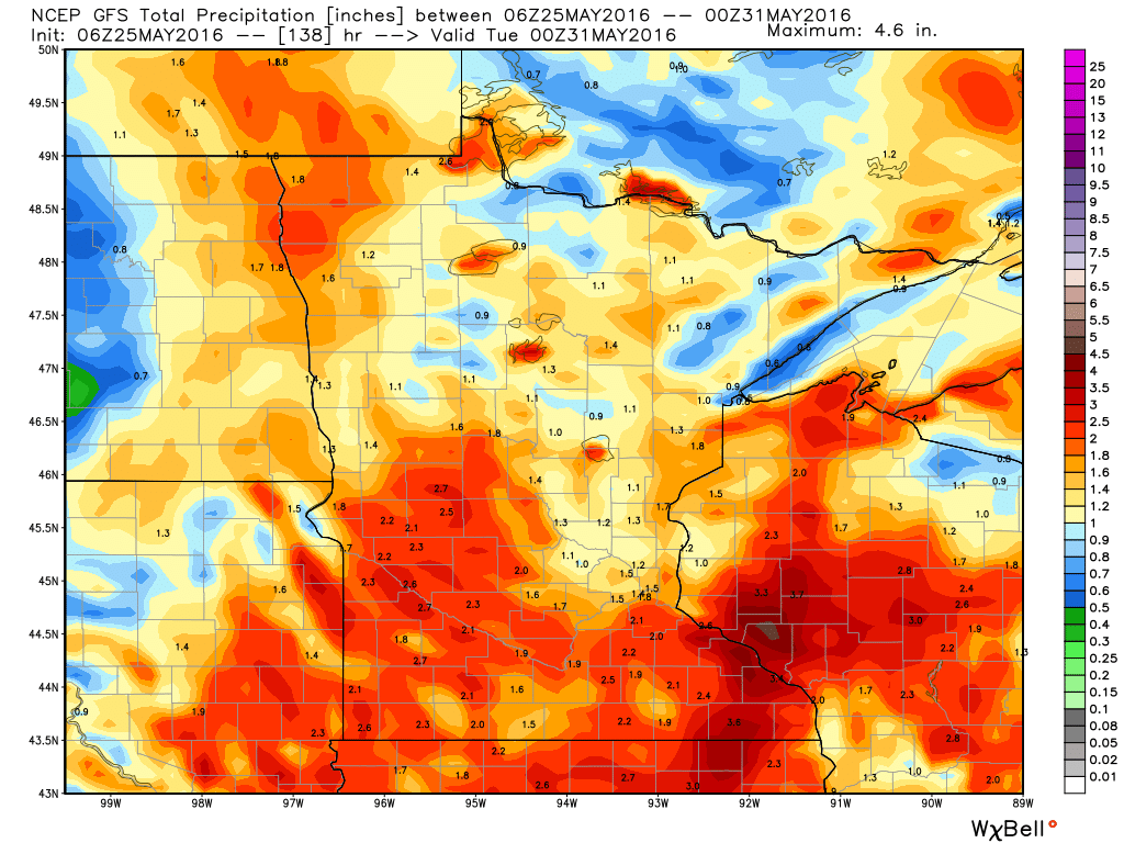
Extended Minnesota Rainfall
The extended GFS rainfall forecast through 7pm Monday suggests fairly widespread 1" to 2" rainfall tallies across Minnesota and Wisconsin. Note that most of this rainfall appears to move in from PM Friday through Saturday. Sunday looks like the nicer day of the holiday weekend as a few late storm storms may pop up on Memorial Day Monday.
National Weather Outlook
Active weather looks to continue across the Central U.S. with numerous showers and storms continuing through the end of the week. Keep in mind that some of the storms could be strong to severe with areas of heavy rainfall and flooding.
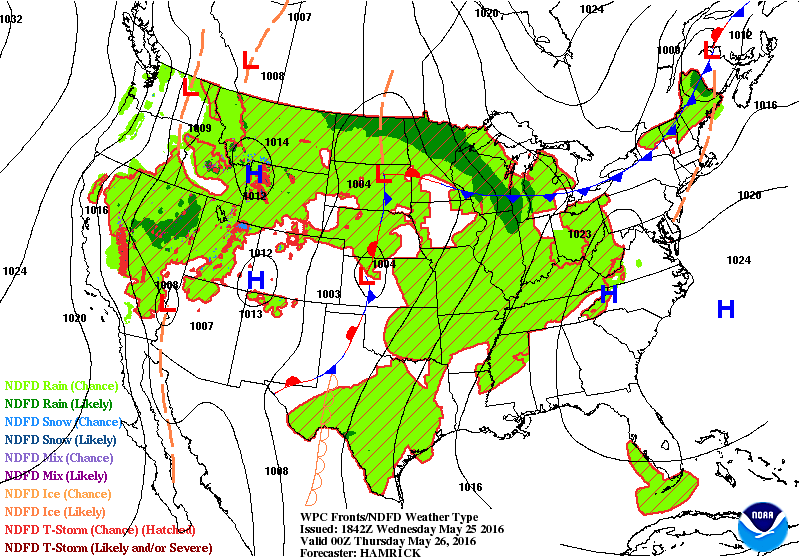
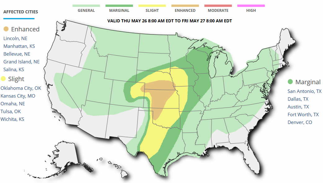
Severe Weather Concerns Thursday
...SUMMARY...
   SEVERE THUNDERSTORMS CAPABLE OF TORNADOES AND VERY LARGE HAIL ARE
   EXPECTED ACROSS MUCH OF SOUTHERN NEBRASKA INTO NORTHERN KANSAS FROM
   LATE AFTERNOON INTO EARLY EVENING ON THURSDAY...WITH MORE ISOLATED
   SEVERE STORMS EXTENDING SOUTHWARD INTO WESTERN OKLAHOMA AS WELL AS
   INTO NORTHEASTERN COLORADO. OTHER MARGINALLY SEVERE STORMS WITH HAIL
   AND STRONG WIND GUSTS MAY OCCUR ACROSS PARTS OF THE MID TO UPPER
   MISSISSIPPI VALLEY AND SOUTHWESTERN GREAT LAKES REGION.

   ...SYNOPSIS...
   AN UPPER TROUGH WILL MOVE INTO THE CNTRL AND SRN PLAINS ON THURSDAY
   WITH UPPER LOW CENTERED OVER CO AT 00Z AND A 50-60 KT MIDLEVEL JET
   MAX MOVING INTO WRN TX. AT THE SURFACE...LOW PRESSURE WILL DEEPEN
   ALONG THE CO/KS BORDER WITH A WARM FRONT BECOMING ESTABLISHED NEAR
   THE KS/NE BORDER BY LATE AFTERNOON. THE DEEPENING LOW WILL BACK SFC
   WINDS ACROSS NEB...WITH THE BETTER LOW-LEVEL MOISTURE EXTENDING WWD
   INTO NERN CO. TO THE S...A DRYLINE WILL EXTEND SSEWD FROM THE LOW
   INTO WRN OK...THEN BECOMING STATIONARY AND RETREATING INTO WRN TX
   LATE. THE WARM SECTOR WILL REMAIN EXTREMELY UNSTABLE WITH UPPER 60S
   TO NEAR 70 F DEWPOINTS BENEATH STEEP LAPSE RATES ALOFT. DEEP LAYER
   WIND FIELDS WILL SUPPORT SEVERE STORMS WITH A 50+ KT LOW-LEVEL JET
   DEVELOPING NEAR OR AFTER 00Z PERHAPS SUPPORTING A FEW STRONG
   TORNADOES ACROSS MAINLY SRN NEB INTO CNTRL KS ALONG WITH VERY LARGE
   HAIL.

   ANOTHER AREA OF SEVERE STORMS IS LIKELY INTO SWRN/CNTRL TX LATE IN
   THE DAY INTO THE EVENING AS THE BASE OF THE UPPER TROUGH SPREADS
   OVER A VERY MOIST AND UNSTABLE AIR MASS.
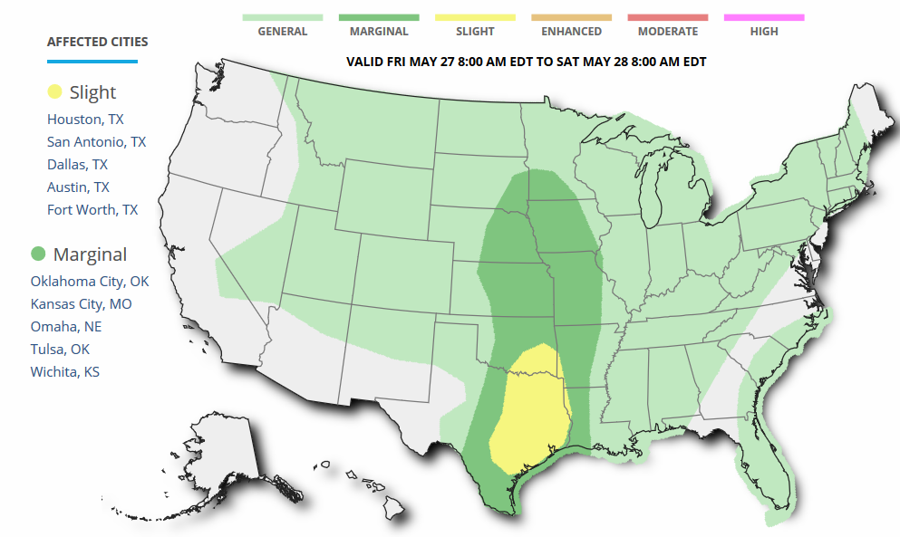
Severe Threat Friday
...SUMMARY...
   STRONG TO SEVERE THUNDERSTORMS WILL BE POSSIBLE OVER PORTIONS OF
   TEXAS AND OKLAHOMA ON FRIDAY.  OTHER MORE ISOLATED STRONG TO SEVERE
   THUNDERSTORMS ARE FORECAST FROM THE CENTRAL PLAINS INTO PARTS OF THE
   MIDWEST.

   ...SYNOPSIS...
   A CNTRL U.S. MID-LEVEL TROUGH AND ASSOCIATED LOW NEAR CO/NM WILL
   LIFT NEWD AND WEAKEN WITH TIME AS IT MOVES ACROSS THE SRN-CNTRL
   PLAINS.  A SURFACE LOW WILL MIGRATE NEWD FROM THE CNTRL PLAINS INTO
   THE UPPER MS VALLEY WITH A COLD FRONT MOVING ACROSS THE N-CNTRL
   STATES.  A RESIDUAL DRYLINE/LEE TROUGH WILL EXTEND SWD INTO THE SRN
   PLAINS.
_______________________________________
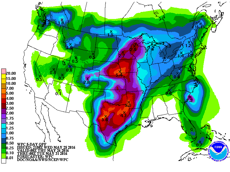
Heavy Rainfall Potential
According to NOAA's WPC, the 5 day rainfall forecast suggests heavy rainfall of up to 4" to 5"+ across parts of the Central U.S. through Memorial Day Monday. This heavy rainfall cloud lead to areas of flooding from parts of the Upper Midwest to Texas.
____________________________________________
Invest 91L
While the blob of clouds in the IR satellite below doesn't look like much, it is actually being watched by the National Hurricane Center as an area of possible tropical development.
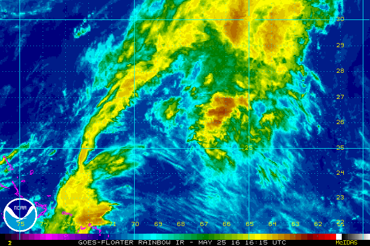
Tropical Development?
Well Well Well... Look at what's happening in the Atlantic Basin. The National Hurricane Center is keeping an eye on a disturbance north of the Bahamas moving northwest toward the southeastern U.S. coast. Interestingly, the NHC has a 60% of tropical development with the next 5 day!
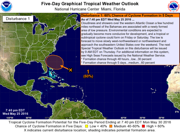
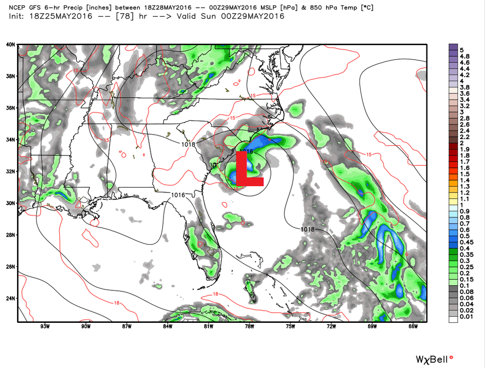
Developing Coastal Storm?
Take a look at the forecast for PM Saturday! The area of concern in the north of the Bahamas now looks to continue drifting northwest toward the Carolinas with the of heavy rain, strong winds and heavy surf for the Memorial Weekend. Stay tuned...
________________________________________
"10 Ways Climate Science Has Advanced Since An Inconvenient Truth"
"The aughts were an inconvenient time for environmentalism. President George W. Bush declared the Kyoto Protocol, the first international treaty meant to address climate change, dead. Environmentalists charged widespread political interference in climate change science conducted at federal agencies. Most people had not heard of global warming. Then former Vice President Al Gore’s “An Inconvenient Truth” landed with a thud on the public’s consciousness. It grossed $24 million, won two Academy Awards and earned Gore the Nobel Peace Prize. With the 10-year anniversary of “An Inconvenient Truth” coming up this week, ClimateWirerewatched the film to see if the science still held up and found a number of its predictions have since come true. In some cases, the reality is even worse than the forecasts. And a few times, Gore got it wrong. Here, a decade after its release, are 10 ways our knowledge of the planet has evolved since Gore’s movie"
Read more from ScientificAmerican.com HERE:
 _____________________________________________
Thanks for checking in and have a great rest of your week! Don't forget to follow me on Twitter @TNelsonWX

No comments:
Post a Comment