74 F. high in St. Cloud Friday.
70 F. average high on May 20.
63 F. high temperature on May 20, 2015.
May 21, 1960: A downpour at New Prague dumps 10 inches of rain in a 48 hour period.
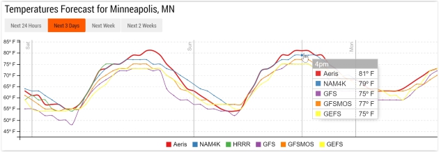
A Weekend to Remember - Memorial Weekend Preview"Weekends
are a bit like rainbows; they look good from a distance but disappear
when you get up close to them" said John Shirley. The weekend weather
forecast can be a meteorological mirage. Things look great
on Tuesday, but often by
Friday
those little smiling sun symbols have frowns and lightning bolts. It's
maddening for you - it's craze-inducing for meteorologists.
So why
does the forecast change so much? We receive 4 new model updates every
day. As new balloon, ocean buoy, airport and satellite data arrives it
powers the computer simulations of what the atmosphere should look like
in the future. New data; fresh observations can result in a radically
new forecast, especially beyond Day 3.
A high pressure bubble parked directly overhead results in a stunning
Saturday; increasing south winds tug the mercury up to 80F
Sunday. Garden-variety thundershowers arrive
Monday. A series of stormy swirls eject across the Plains into Minnesota next week. The best chance of rain:
Wednesday and
next Saturday.
Skies may try to clear by
Sunday and
Monday of the Memorial Weekend as temperatures warm up again.
Feeling lucky?
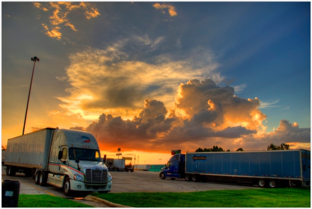
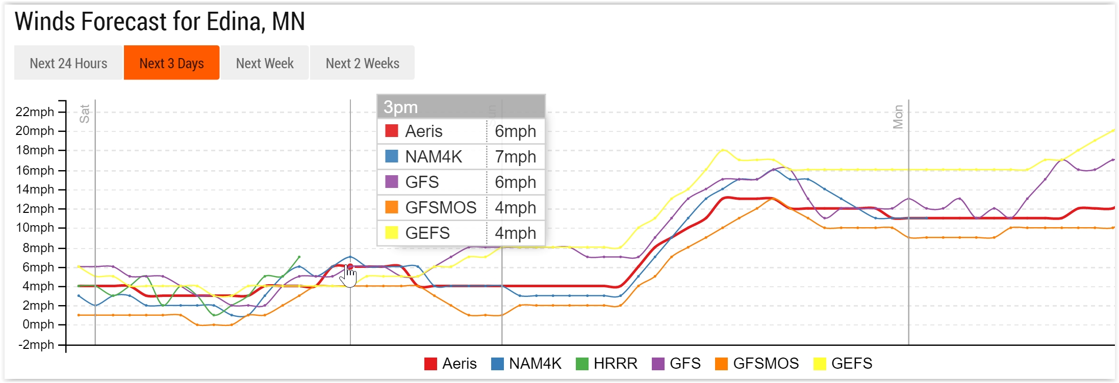 Today: Postcard Weather
.
Blue sky, low humidity, mid to upper 70s by late afternoon, and
(unusually) light winds with the center of high pressure close to MSP;
sustained winds forecast to remain in the 5-10 mph range this afternoon.
Graphic: Aeris Enterprise.
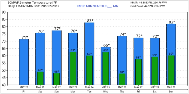
Low 80s Possible Sunday.
As southerly winds increase tomorrow warmer air will be pulled into
Minnesota; a good chance of temperatures passing the 80F mark by
mid-afternoon.
Early Word on Memorial Weekend: Sunday and Monday May Be Best Days.
It's way too early to draw definitive conclusions for the holiday
weekend, but models suggest Saturday may be the coolest, wettest day.
ECMWF guidance hints at 80s returning next Sunday with sunshine. We may
salvage a fair amount of fine summer weather, after all. Graphic:
WeatherBell.
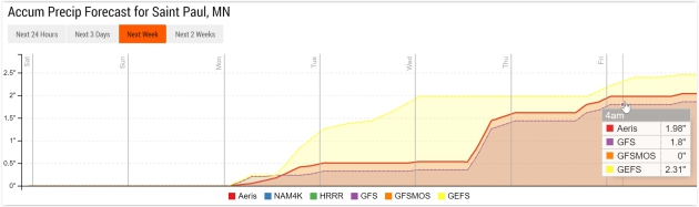
Increasingly Soggy Next Week.
One band of showers pushes across the Upper Midwest Monday, but heavier
rains are likely Wednesday, again Saturday of next week. Proving that a
major holiday is shaping up. Check out the excessive (10"+) rainfall
amounts predicted for Haiti and the Dominican Republic over the next 10
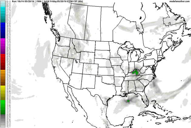
days by NOAA's GFS model. Loop: AerisWeather.
A Fine Dousing.
Monday is just the wet-weather appetizer with a few hours of showers
and possible thunder (nothing severe expected) but heavier rain is
forecast for the middle of next week; perhaps as much as 2" of rain for
portions of the metro by the end of next week. Did I mention we're
sailing into a holiday? Forgive me for not being surprised.
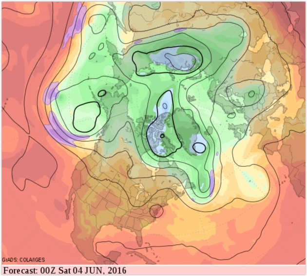
Warm and Muggy Start to June.
Long-range GFS guidance hints at 90-degree heat for the Mid Atlantic
region and the Central and Southern Plains; temperatures probably
trending warmer than average for Minnesota and Wisconsin the first week
of June.
Hello Summer.
NOAA's GFS guidance confirms that 70s and 80s should be the rule from
late May into the first week of June with more numerous T-storms - and
significantly higher dew points. Enjoy this comfortable airmass while
you can.
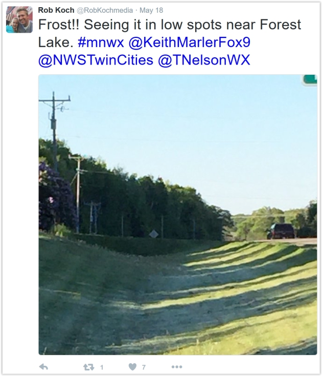
Widespread Frosts May 14-18. Dr. Mark Seeley reports spotty frost-related damage across the state; here's an excerpt of his latest installment of
Minnesota WeatherTalk: "
A
persistent dry high pressure system brought repeated frosts to many
parts of Minnesota over the period May 14-18 this week. Many farmers
have assessed the damage to crops, but in most cases corn was not
significantly damaged because it was early enough in the growth cycle
that the growing point was below the soil service. There was some damage
to early planted soybean fields, but that represents a relatively small
percentage of the acreage. Elsewhere some spotty damage to apple trees,
grape vines, and fruit were reported. In fact those 5 days also
produced over 30 new daily record low temperature values across the
observational climate networks in the state..."
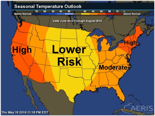
Summer Scorcher? Forecasts Call For a Hot One. A story at
USA TODAY caught my eye; here's a link and story excerpt: "
Hot
weather lovers, your time is coming. Most of the nation should see a
warmer-than-average summer, according to a forecast released Thursday by
the National Oceanic and Atmospheric Administration. That jibes with
other forecasts released earlier this month by private forecasters such
as the Weather Channel and AccuWeather. Both the East and West Coasts
are expected to see the most extreme heat, NOAA said. The one area that
might be near average is the central Plains..."
Map credit: Probability of warmer than average temperatures, June thru August, courtesy of NOAA Climate Prediction Center and
AerisWeather.
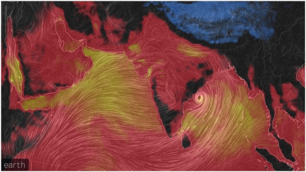
India Just Recorded Its Hottest Temperature On Record: 123.8 Fahrenheit. Andrew Freedman reports on staggering heat gripping India at
Mashable: "
India
just set a new national record heat benchmark when the small city of
Phalodi, in northwest India, recorded a high temperature of a whopping
51 degrees Celsius, or 123.8 degrees Fahrenheit, on May 19. The
data, recorded by the India Meteorological Department (IMD), shows that
the high temperature eclipsed the previous national high temperature of
50.6 degrees Celsius, which was set way back in 1886. The all-time record comes during a stifling heat wave that has enveloped much of the country following a series of deadly heat waves earlier this spring that struck India, Thailand, Cambodia and other parts of Southeast Asia..."
Map credit: "Misery Index showing temperatures plus dewpoint levels across India on May 19, 2016." Image: Earth Simulator.
*
The BBC has more details on record heat in India
here.
Pray for Shade: Heat Wave Sets a Record in India.
The New York Times provides more perspective: "
People weren’t frying eggs on the sidewalks in Phalodi during India’s
hottest day ever — in fact, it was so hot that many did not venture out
at all. Heat is a familiar part of life in Phalodi, in the deserts of
Rajasthan, so residents were following a familiar drill even before
temperatures soared to 123.8 degrees Fahrenheit on Thursday: When the
heat comes, stay indoors, chug buttermilk and, if you must go out, cover
your head and pray for shade. It is a drill that may prove ever more
necessary if temperatures continue to rise..."
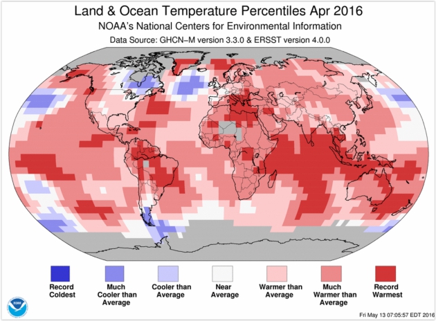
Highest Temperature Departure for April Since Records Began in 1880. Not my words but NOAA's. Here's an excerpt from a
recent summary: "...
The
combined average temperature over global land and ocean surfaces for
April 2016 was 1.10°C (1.98°F) above the 20th century average of 13.7°C
(56.7°F)—the highest temperature departure for April since global
records began in 1880. This value surpassed the previous record set in
2010 by 0.28°C (0.50°F). This was also the fourth highest monthly
temperature departure among all 1,636 months on record, behind March
2016 (1.23°C/2.21°F), February 2016 (1.19°C/2.14°F), and December 2015
(1.12°C/2.02°F). Overall, 13 out of the 15 highest monthly temperature departures in the record have all occurred since February 2015, with February 1998 and January 2007 among the 15 highest monthly temperature departures..."
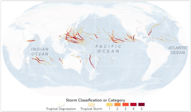
2015: Record Year for (Major) Hurricanes in the Northern Hemisphere.
NASA's Earth Observatory has the details: "...
Thirty
major hurricanes, typhoons, and cyclones occurred in the northern
hemisphere in 2015; the previous record was 23 (set in 2004).
Twenty-five of those storms reached category 4 or 5, well beyond the previous record of 18. The maps above and below are based on data from Unisys Weather,
which compiles information from the U.S. National Weather Service and
the Joint Typhoon Warning Center. The maps show the tracks and intensity
of all tropical cyclones in 2015; first globally, then in the eastern
and western Pacific basins..."
Hurricane Hunters Pierce Heart of Storm With Skill. Here's a clip from a story at
The Houston Chronicle that caught my eye: "...
Once
they find the windless, dead center, Sr. Master Sgt. Jay Latham, the
loadmaster, loads a spring-loaded cannon with small tubes, known as
dropsonde, packed with instruments. Latham fires the tubes out the
bottom of the aircraft. Parachutes open and they drift away, taking
readings that are radioed to Bundy's instruments until they land in the
ocean, where the water destroys their electrical system. Going into the
jaws of a hurricane takes experience and teamwork. "It takes a very
experienced crew to make this work easily," Latham said. "It takes two
to three years before guys are up to speed."
Photo credit above:
Photo: Marie D. De Jesus, Staff. "Master
Sgt. Ed Scherzer shows how a spring-loaded cannon with small tubes and
packed with instruments, known as dropsonde, is dropped into a hurricane."
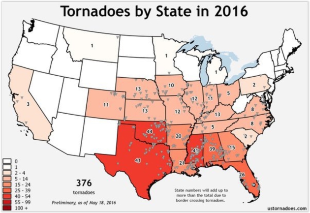
2016 Tornado Count. A tip of the hat to Bill Steffen at
WOOD-TV in Grand Rapids, Michigan for some tornado-perspective: "
The
states that have had the most tornadoes this year are Texas (big
state), Oklahoma, Mississippi and Alabama. Michigan has had one small tornado this year, which went through the town of Edwardsburg in Cass Co. back on March 24th. That twister was on the ground for 1.4 miles, was up to 150 yards wide and had peak winds of 75 mph..." (Map credit:
ustornadoes.com).
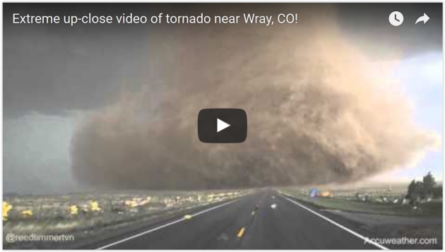
 Remarkable Tornado Footage
. Here's a link and story excerpt from
For The Win: "
In this terrifying footage captured on May 9th, a tornado rips through the towns of Katie and Wynnewood, Oklahoma..."
"More Will Die": The Ethics of Up-Close Tornado Chasing. Sadly, I have to agree with Jason Samenow at
The Capital Weather Gang: "
Daring storm
chasers have come perilously close to violent tornadoes this spring
while acquiring some of the most dramatic storm scenes ever filmed. But
the videos have raised important questions about how aggressive chasers
should be when they pursue these storms, whether for the thrill or for
research. How close is too close? Does “extreme” close-up video,
obtained and sold by chasers and shared by media for profit, encourage
copycat chasing that puts people’s lives at risk?..."
Since Joplin Tornado, Dozens of Safe Rooms Built in Area Schools, Communities. A story at
KSMU Radio made me do a double-take, highlighting some of the lesson's of Joplin's EF-5 tornado: "...
For
the schools without, the procedure during a severe weather event is to
move students to interior rooms, rather than the old method of seeking
shelter in the hallways. “After looking at Joplin, some of the places
that were the least damaged were inside classrooms or in closets or
those bathrooms or something like that,” Rantz says. “There’s still
damage but they were more intact, and the hallways were actually some of
the most dangerous spots...”
When Severe Weather Strikes, Where Can You Find Shelter When You're On The Road. Here's an excerpt of an interesting story and good advice (for everyone) at
Land Line Magazine, catering to long-distance truckers: "...
The
rule is pretty simple: Inside beats outside. Below ground beats above
ground. First floor beats upper floors. If you can get out of your
vehicle, and into a building, preferably below ground, that's what you
should do," said Keith Stammer, the longtime emergency management
director of Joplin, Mo., and no stranger to the devastation that can be
wrought by a massive tornado..."
Photo credit:
Overdrive Magazine.
“The
rule is pretty simple: Inside beats outside. Below ground beats above
ground. First floor beats upper floors. If you can get out of your
vehicle, and into a building, preferably below ground, that’s what you
should do,” said Keith Stammer, the longtime emergency management
director of Joplin, Mo., and no stranger to the devastation that can be
wrought by a massive tornado.
If no shelter is available, every
emergency official interviewed said being outside of the vehicle in a
low-lying area was still safer than staying in the cab of the truck,
although they cautioned to make sure that the low-lying area wasn’t an
immediate risk for flash flooding.
- See more at: http://www.landlinemag.com/Story.aspx?StoryID=31201#.Vz-awr4fgkc
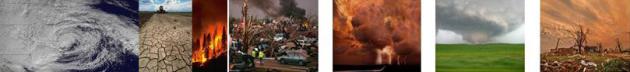
7 States With The Most Dangerous Weather.
I was surprised to see Nevada and Wyoming make the cut; the findings
for Alabama are skewed by a particularly violent series of tornado
outbreaks in 2011. Here's an excerpt from
24/7 Wall St: "...
While
geography and climate play a central role in dangerous weather, poverty
amplifies its negative effects. According to a report from the Centers
for Disease Control and Prevention, weather-related death rates are “2
to 7 times as high in low-income counties as in high-income counties.”
This is likely because those living below the poverty line to not have
the means to prepare for, or adapt to, extreme weather events and
conditions, according to the CDC. It is perhaps no coincidence that the
poverty rate is as high or higher than the 15.6% national rate in each
of the states on this list except for Wyoming..."
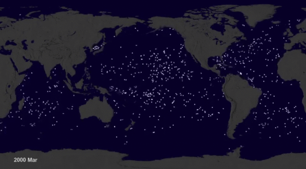
Watch Buoys Dance With The Flow in This Ocean Current Visualization. Here's an excerpt from
Atlas Obscura: "...
The visualization, which was a finalist
in the American Association of the Advancement of Science’s Data
Stories competition, used data the National Oceanic Atmospheric
Administration collected from more than 17,000 free-floating buoys
released over 35 years—the buoys are represented by the white
fluttering dots. NASA visualization scientist, Greg Shirah, points out
how the buoys form different patterns. Some follow vessels and ships in
straight lines and others scatter in the direction of the current.
However, the dots eventually get caught in five distinct trash vortexes..."
Scientists Urge Cooperation To Save North America's Migratory Birds. Here's a clip from
Christian Science Monitor: "...
About
a third of North America's 350 migratory bird species are facing
extinction at an unnaturally fast pace. Since 1970, already a billion birds have disappeared
from the continent. As people settle upon and destroy native grasslands
that birds such as the Sprague's pipit use to procreate every summer,
it becomes clear the birds' well-being relies heavily on the health of
their ecosystems. "The battle to protect migratory birds is ongoing.
Whatever we do in Canada will be ineffective unless that is equalled in
the wintering grounds, and vice versa," said Mr. Artuso..."
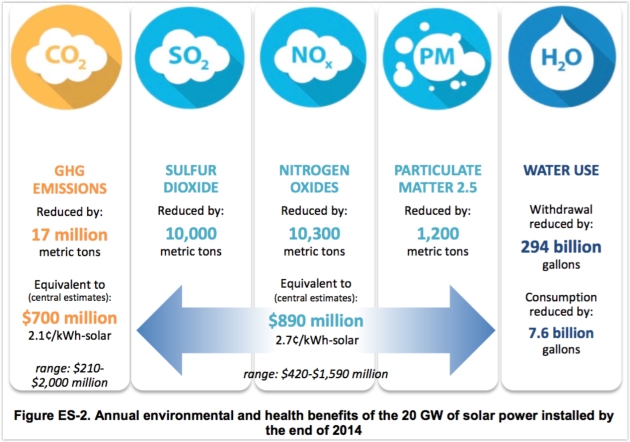
Solar Power Is Already Saving Lives in the U.S. Here's How. Here's an excerpt of an explainer from Dave Roberts at
Vox: "...
It's
worth keeping in mind that the somewhat clinical phrase "domestic air
quality benefits" is another way of describing fewer kids having asthma
attacks, fewer adults missing workdays, and fewer people dying of
respiratory and circulatory ailments. It's also worth keeping in mind
that none of these social benefits are priced into the cost of solar; it
is not compensated for its "positive externalities." If it were, it
would knock almost 5 cents a kilowatt-hour off the price, which would
mean the Sunshot cost target was already achieved..." (Graphic credit: Department of Energy).
 Ebola Czar: America Failing on Zika
.
POLITICO has the story - here's the intro: "
The
man who led the successful White House response to the Ebola outbreak
says the Zika virus is a slow-motion public health disaster — and
Congress is to blame. Ron Klain, who served as White House Ebola czar
and as Vice President Joe Biden’s chief of staff, told POLITICO's “Pulse Check” podcast
that Congress has failed to heed the lessons of the Ebola epidemic and
that the Zika funding battle has become unforgivably partisan in the
face of such dire human costs, including severe brain defects in
infants..." (Image: Climate Nexus).
Google To Introduce Its Voice-Activated Home Device. I fear Google knows me better than I know myself. Now I can talk back to myself. Here's an excerpt from a
New York Times story: "
Google
will introduce its much-anticipated entry into the voice-activated home
device market on Wednesday, according to people who spoke on the
condition of anonymity. Named Google Home, the device is a virtual agent
that answers simple questions and carries out basic tasks. It is to be
announced at Google’s annual developers’ conference in Silicon Valley.
Google Home will come to market in the fall — a long time away, given
the speed of technology, but Google needed to plant a stake in the
ground now. The device will compete with Amazon’s Echo, which was introduced less than two years ago. Amazon has already sold an estimated three million units..."
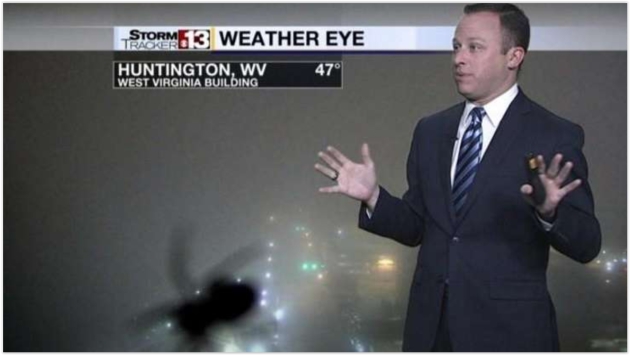
Watch This Weatherman's Epic Freak Out After Spotting a Spider During a Live Broadcast. Forget zombies, it's the giant spiders we need to worry about. Here's a link to the video clip and story excerpt from
MSN News: "
Tonight's forecast: Cloudy with a chance of shrieks. A weather reporter
in West Virginia with a severe case of arachnophobia got ultimate scare
when a spider appeared during a live broadcast. Bryan Hughes was giving his report
when the invading arachnid creepily crawled onto his monitor, making
him squeal in fear. “Ah! Geez Louise,” he yelled after spotting his
eight-legged nemesis..."
Image credit:
Provided by CBS Interactive Inc. "One reporter went from giving the news to becoming it after he spotted a spider in the studio."
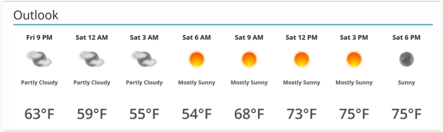
TODAY: Bright sun, light winds, just about perfect. Winds: SE 5-10. High: 77
SATURDAY NIGHT: Clear and pleasant. Low: 57
SUNDAY: Partly sunny, warmer & windier. Winds: S 10-20+ High: 81
MONDAY: Showers likely, rumble of thunder? Winds: S 10-20. Wake-up: 60. High: 76
TUESDAY: Some sticky sun, warmer. Winds: SW 5-10. Wake-up: 61. High: 83
WEDNESDAY: Rain likely, possibly heavy. Cooler. Winds: E 10-20. Wake-up: 62. High: near 70
THURSDAY: Glimmers of sun, temporarily drying out a bit. Winds: NW 7-12. Wake-up: 55. High: 77
FRIDAY: More showers, possible T-storms. Winds: SE 10-15. Wake-up: 59. High: 74
Climate Stories...
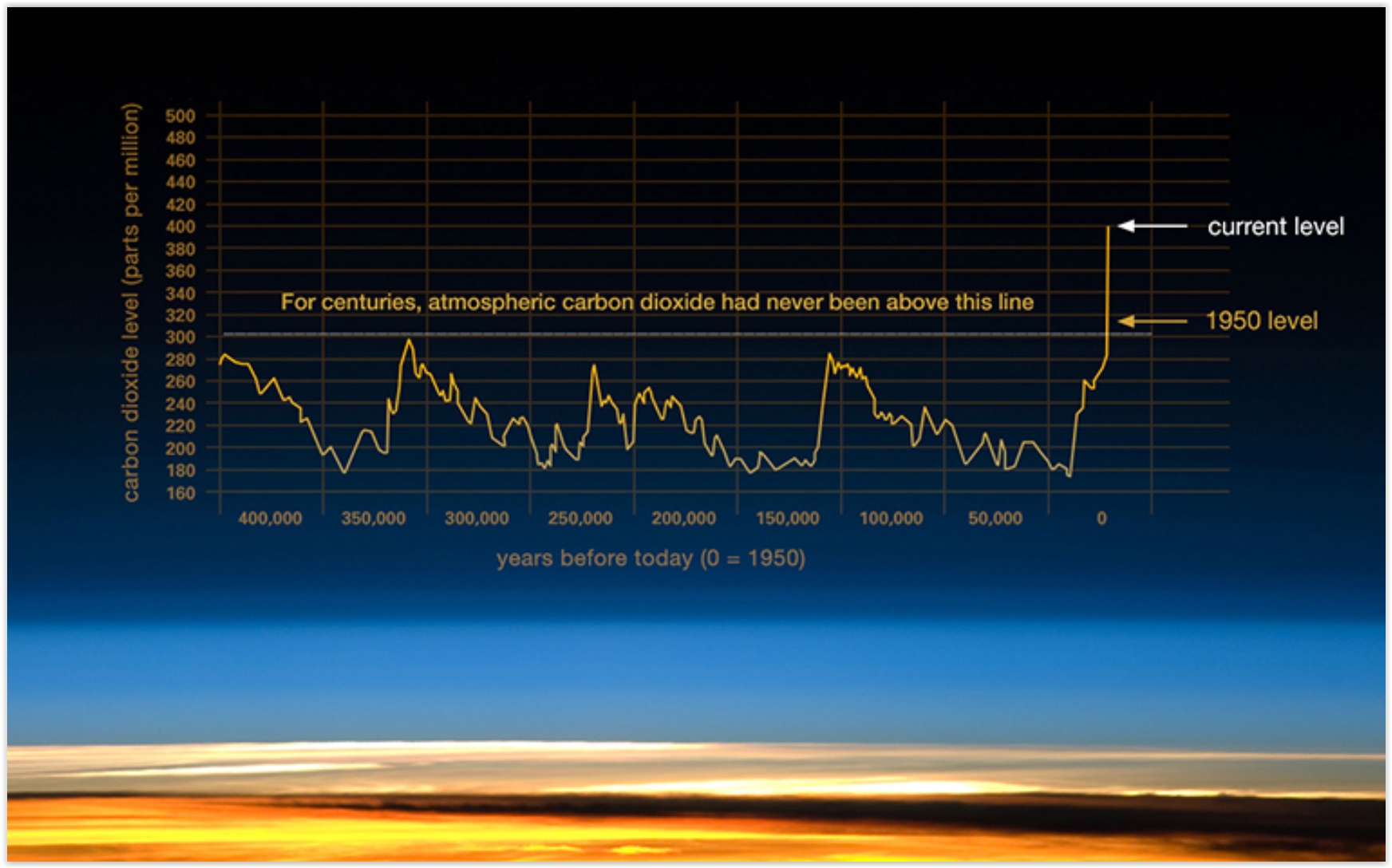 Carbon Dioxide's 400 ppm Milestone Shows Humans are Rewriting the Planet's History.
 Here's an excerpt of a post at
The Guardian: "...
So
when was the last time the planet had CO2 levels like this, and what
sort of a world was it? Dr David Etheridge, a principal research
scientist at Australia’s CSIRO, told me: “We know [levels of CO2 in the
atmosphere] from the air extracted directly from ice cores and we can go
back to about 800,000 years ago. It is inconceivable that there would
be any lasting concentration of CO2 much above about 300 parts per
million in that record.” He says analysis of sea sediments can push our
estimates of historic CO2 levels back even further – to about two
million years. Those records also show today’s levels of CO2 are higher..." (Graphic credit:
NASA).
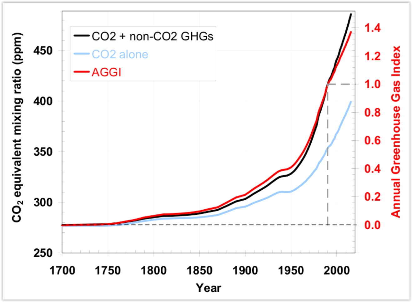
Far From Turning a Corner, Global CO2 Emissions Still Accelerating.
InsideClimate News has an update: "
The
level of carbon dioxide in the atmosphere is not just rising, it's
accelerating, and another potent greenhouse gas, methane showed a big
spike last year, according to the latest annual greenhouse gas index released by the National Oceanic and Atmospheric Administration.
CO2 emissions totaled between 35 and 40 billion tons in 2015, according
to several agencies. Some of that is absorbed by forests and oceans,
but those natural systems are being overwhelmed by the sheer volume of
new CO2. As a result, the inventory shows, the average global
concentration increased to 399 parts per million in 2015, a record jump
of almost 3 ppm from the year before..."
Graphic credit: "The greenhouse gas inventory shows an accelerated rise in concentrations in recent years." Credit: NOAA.
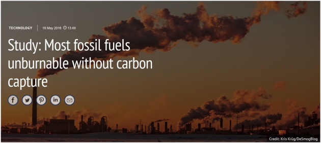
Study: Most Fossil Fuels Unburnable Without Carbon Capture. Here's the intro to a story at
Carbon Brief: "
The
majority of fossil fuel reserves are unburnable if the world is to
avoid dangerous climate change, but carbon capture and storage (CCS)
could “unlock” greater use, a new study concludes. The white paper, from Imperial’s Sustainable Gas Institute,
challenges previous findings that CCS makes little difference to the
quantity of fossil fuels that can be burned, within a 2C carbon budget..."
Photo credit: Kris Krug, DeSmogBlog.
Climate Signals. Check out the beta of the new
Climate Signals web site,
where you can plug in specific key words or your zip code to get
highly-relevant articles and updates related to climate change.
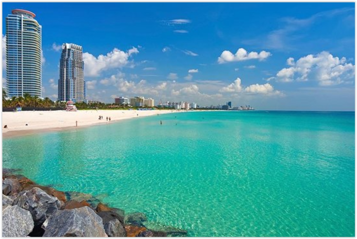 Researchers Help Miami Community Plan For Sea Rise, Climate Change
. Here's an excerpt from
The Miami Herald: "...
In a recent op-ed, Merleaux wrote about the project
and explained environmental problems facing Miami, South Florida and
the world. According to her findings, “scientists predict between 4-6
feet of sea level rise here by the end of the century. These changes
will require people to make some very difficult decisions as they
prioritize how to invest and what to protect.” Although she has only
lived in Miami for six years, the mother of two said she is concerned
for her family, neighborhood and the global community..."
Read more here: http://www.miamiherald.com/news/local/community/miami-dade/community-voices/article78670637.html#storylink=cpy
What are Donald Trump's Views on Climate Change? Some Clues Emerge. Here's an excerpt from
The New York Times: "...
In
an interview, Mr. Cramer said he wrote in the briefing paper that a
growing number of Americans wanted action to reduce carbon dioxide
emissions from fossil fuels. And he outlined a broad energy policy that
embraced all types of fuel sources — including coal, oil, solar, wind
and hydropower — that he called an “all-of-the-above, America-first
energy message.” Mr. Cramer, from a heavy coal- and oil-producing state,
said it was important that any policy does not “punish coal” or other
fossil fuels..."
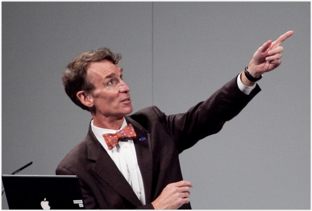
Why I Choose to Challenge Climate Change Deniers. Here's an excerpt of an Op-Ed from Bill Nye, The Science Guy, at
Huffington Post: "...
Since
the presentation of the facts and science concerning global warming and
climate change have been heretofore insufficient to motivate enough of
us voters, I am now challenging the deniers directly. By showing enough
people the techniques and ignorance of the deniers, I believe we can
make warming and climate change a campaign issue, which will swing the
upcoming U.S. presidential election in favor of a candidate who is not
out of touch with our worldwide climate situation..."
Photo credit: Wikipedia.
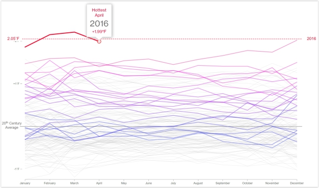
Earth's Relentless Warming Just Hit a Terrible New Threshold. Here's the introduction to a story at
Bloomberg: "
The
number of climate records broken in the last few years is stunning. But
here's a new measure of misery: Not only did we just experience the
hottest April in 137 years of record keeping, but it was the 12th
consecutive month to set a new record. It's been relentless. May 2015
was the hottest May in records dating back to 1880. That was followed by
the hottest June. Then came a record July, August, September, October,
November, December, January, February, March—and, we learned from the
National Oceanic and Atmospheric Administration on Wednesday—the hottest
April. In an age of rising temperatures, monthly heat records have
become all too common. Still, a string of 12 of them is without
precedent..."
Graphic credit: GHCN-M & ICOADS Data Sets Provided by NOAA. GRAPHIC: Blacki Migliozzi
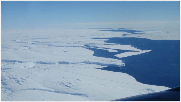
"Fundamentally Unstable": Scientists Confirm Their Fears About East Antarctica's Biggest Glacier. Chris Mooney has the story at
The Washington Post: "
Scientists
ringing alarm bells about the melting of Antarctica have focused most
of their attention, so far, on the smaller West Antarctic ice sheet,
which is grounded deep below sea level and highly exposed to the
influence of warming seas. But new research published
in the journal Nature Wednesday reaffirms that there’s a possibly even
bigger — if slower moving — threat in the much larger ice mass of East
Antarctica. The Totten Glacier holds back more ice than any other in
East Antarctica, which is itself the biggest ice mass in the world by
far..."
Photo credit: "
Aerial photo of Totten Glacier’s ice shelf edge." (Jamin Greenbaum)
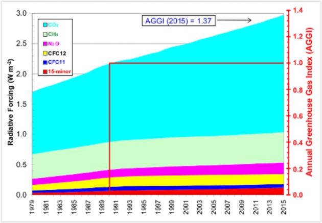
NOAA: Global Warming Effect of Emissions Up 37 Percent Since 1990. Here's an excerpt from
Colarado Public Radio: "
The
warming effect of greenhouse gases got a little bigger last year,
according to new data from the National Oceanic and Atmospheric
Administration. And unfortunately for us, it's gotten a little bit
bigger each year for awhile now. The latest installment of NOAA's Annual
Greenhouse Gas Index shows an increase of 37 percent since 1990..." (Graphic credit: NOAA).
If You Care About Kids, You Care About Climate.
NRDC.com takes a look at a new study - here's a story excerpt: "...
Regardless
of what else we may believe in, we all can get behind making the world a
better place for our children. The wish to see them grow and prosper in
a safe, stable, and healthy environment transcends ideology or
political partisanship. I’ve come to understand what all parents come to
understand: Having kids really does change the way you think about the
world, and especially about where we’re all headed. To take
responsibility for a child’s life is to take responsibility for that
child’s present—and future—environment. A new report underscores the
staggering importance of that responsibility and also provides a
scorecard as to how seriously we’ve been taking it. In doing so, Children and Climate Change, which was copublished by Princeton University and the Brookings Institution..."


No comments:
Post a Comment