81 F. high on Sunday in St. Cloud.
74 F. average high on June 5.
74 F. high on June 5, 2015.
June 6, 1915: This date marks the first of a long stretch of days of measurable rain at Winton near Ely. Measurable rain would fall on each day until 19th. The total amount of rain for the fifteen days was over six inches. (Source: Twin Cities National Weather Service).
Monday Showers - Stinking Hot Weekend Brewing
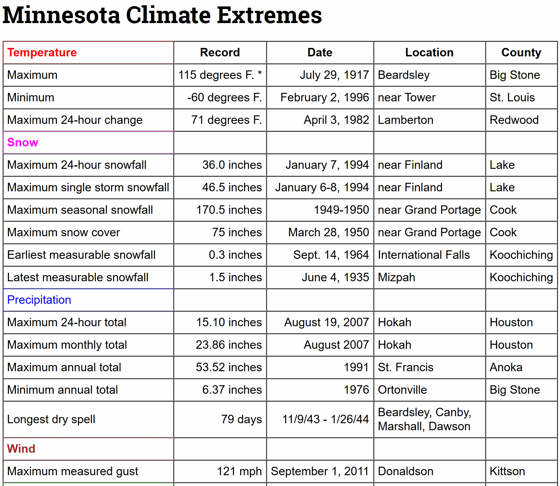
"What amazes you about Minnesota's weather"?
"What amazes you about Minnesota's weather"?
I
get that question a lot - how much time do you have? I am still
awestruck by the extremes. Few other spots on the planet can go from
-60F to 115F. The rate at which we often go from flood to drought. And
how quickly the weather at this latitude can change. Like turning on a
light switch some weeks.
This
will be one of those weeks. Showers and 60s today give way to a run of
90s by late week, in fact ECMWF (European) model guidance predicts 4
days in a row above 90F, starting Friday. Mid-90s, coupled with a sauna-like dew point in the 70s, could leave us with a heat index above 100F by Friday.
I may have to squeeze into my Speedo and annoy the neighbors. Sorry for the visual.
The big story is the impending heat spike, but at least we get to dry out this week. Dry weather is the rule Tuesday into Sunday; one week from today a parade of belligerent thunderstorms, some severe, may take the edge off the heat.
No complaints. Tropical Storm Colin is pushing toward Florida with flooding rain bands arriving today. Details below.
* Graphic credit above: Minnesota Department of Natural Resources.

Aeris Weather Briefings: Issued Sunday night, June 5, 2016.
* Tropical Storm Colin slowly intensifying, should strike Big Bend region of Florida's northwest Gulf Coast Monday night with 45-60 mph winds.
* Best-case scenario for Florida, with strongest storm surge hitting a lightly-populated area north of Tampa and Clearwater.
* West (Gulf) coast of Florida will see 2-3" rains with localized flash flooding Monday and Monday night from Naples and Sarasota to Tampa, Panama City and Pensacola.
*
1-3 foot storm surge possible for Tampa Bay, resulting in minor lowland
flooding at high tide; a storm surge in excess of 3 feet is expected
north of Tampa Monday night.

Tropical Storm Colin.
Packing sustained winds of 40 mph the (disorganized) center of Tropical
Storm is 460 miles southwest of Tampa, Florida, moving north at 9 mph.
The storm is expected to slowly intensify over relatively warm water tonight and Monday, reaching the Big Bend area of coastal Florida Monday night as a moderate tropical storm. Likely impacts, courtesy of NOAA NHC:
RAINFALL...Colin is expected to produce rainfall amounts
of 3 to 5 inches with isolated maximum totals of 8 inches possible
across the northeastern Yucatan peninsula, western Cuba, and
Florida.

STORM SURGE...The combination of a storm surge and the tide will
cause normally dry areas near the coast to be flooded by rising
waters.  The water could reach the following heights above ground if
the peak surge occurs at the time of high tide...

Indian Pass to Tampa Bay...1 to 3 ft with slightly higher amounts
possible in a few locations.
Tampa Bay south to Florida Bay...1 to 2 ft.

Localized coastal flooding and dangerous surf is possible along the
Florida East coast, within the Tropical Storm Watch area.

The deepest water will occur along the immediate coast.
Surge-related flooding depends on the relative timing of the surge
and the tidal cycle, and can vary greatly over short distances.  For
information specific to your area, please see products issued by
your local National Weather Service forecast office.

WIND...Tropical storm conditions are expected to first reach the
coast within the warning area by Monday afternoon.  Tropical storm
conditions are possible within the watch area by Monday.

TORNADOES...A few tornadoes are possible on Monday across portions
of Florida and far southern Georgia.

Good Model Agreement on Track. As we reported Sunday morning Tropical Storm Colin is forecast to come ashore between Tampa and Panama City Monday
night; a tight grouping of model solutions increasing our confidence
level to (high) that this will be, in fact, the actual track. The core
of the storm comes ashore over the relatively lightly-populated Big Bend
area of coastal Florida, pretty much a best-case scenario for the
Sunshine State. (Graphic credit: http://www.sfwmd.gov/).

Odds Favor Landfall as a Tropical Storm.
A few (outlier) models bring Colin ashore as a hurricane, but the vast
majority of hurricane models predict tropical storm strength, with
sustained winds of 45-60 mph as the storm reaches land Monday night.
(Graphic credit: Levi Cowan, tropicaltidbits.com).

Potential Storm Surge.
A 1-3 foot surge is possible for Sarasota, Naples and Tampa, with a
higher surge in excess of 3 feet north of Tampa. Remember the highest
surge takes place just to the right (east) of where the center of low
pressure comes ashore.

Significant Risk of Flash Flooding.
Models continue to suggest that the heaviest rains with Colin may fall
just north and west of the storm's track; the greatest potential for
4-6"+ amounts from Panama City to Valdosta, Athens, Charleston and
Columbia. Tampa and Sarasota will see heavy rain bands comes ashore Monday
with 2-4" rains possible, enough for localized flash flooding. I do not
expect widespread power outages for major population centers from
Naples to Tampa, but the combination of strong winds and flooding rains
may result in sporadic outages for the Panhandle Monday night. (Map credit: WeatherBell).
We'll have another update on Tropical Storm Colin Monday morning.
Paul Douglas, Senior Meteorologist. AerisWeather
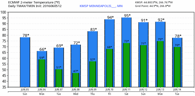
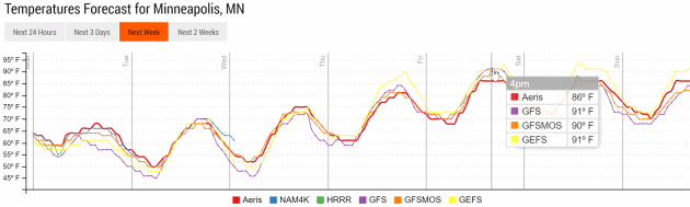

Photo credit: "Mike Akulow, who retired in 2005 after more than 30 years with the National Weather Service in Topeka, says technology used at the time of the June 8, 1966, tornado was "very crude." Today, GPS technology, radar upgrades and an Internet-based chat system has improved the quality and quantity of weather information available."

A Suburban Experiment Aims for Free Energy. Yes, free has a nice ring. Here's the intro to a New York Times story: "At
first glance, Anthony and Vanessa Genau’s home in a subdivision beneath
the San Gabriel Mountains here is like any other gracious new suburban
dwelling, with an open-plan living space, granite countertops and
stainless steel appliances. But, along with 19 other cream, taupe and
rust stucco houses that cradle the landscaped playgrounds here, it is
actually something else: a large-scale testing ground for an energy
system of the very near future. With a combination of rooftop solar
panels, smart thermostats, advanced water heaters and other
high-efficiency features, the homes are all built with a similar goal:
to make at least as much energy as they use over a year..."

10 Household Expenses You Can Eliminate Right Now. If not eliminate, maybe trim? Here's an excerpt of a helpful post at Trulia: "Paying
bills is never fun, but it’s even less exciting when those monthly
expenses: a) keep you from enjoying the cultural events and great
restaurants your city has to offer; or b) leave you eating noodles for
the last few days before every payday. But you don’t necessarily have to
sacrifice the lifestyle you want to live in an apartment or home you
love. In fact, it’s probably easier than you think to eliminate some of
those unnecessary household expenses..."
That
could be bad news for SolarCity and Sunrun, two big solar providers
that currently dominate the U.S. residential solar market. Both
companies have built their businesses around long-term leases, and
third-party ownership of rooftop solar stood at 72 percent in 2014.

A Worldwide Health Check Up. The new Vital Signs series at How We Get To Next is worth your time; here's an excerpt: "Active
energy. Basal body temperature. Blood glucose. Body mass index.
Caffeine intake. Calories ingested. Electrodermal activity. Forced vital
capacity. Heart rate. Hydration level. Oxygen saturation. REM cycles.
Respiratory rate. UV index. These days, we can track just about every
vital sign and body movement we make — and mostly with free apps on our
smartphones. Monitoring and understanding our health is, quite
literally, at our fingertips. And
yet, more Americans are dying. Or at least, given an adult mortality
rate that’s been steadily decreasing over the past half century in the
United States and globally, they did last year..."

Drew Houston of Dropbox: Figure Out The Things You Don't Know. It's a pretty long list. Here's an excerpt of an interesting interview at The New York Times: "...Culture
always starts out as the sort of bizarre average of the founders’
personalities. But a couple of years ago, we decided to define our
values and make our culture explicit. There are a lot of ways to think
about it, but one of them is, how do you build something that sustains
excellence over a long period of time? Or to put it another way, it
seems that most companies, most organisms, decay as they get older and
bigger, and so how do you inoculate your company from the most common
things that tend to go wrong?..."


TODAY: Cool clouds, few showers around. Winds: NW 10-20. High: 67
MONDAY NIGHT: Evening showers, clearing late. Low: 51
TUESDAY: Sunny, breezy and pleasant. Winds: NW 8-13. High: 72
WEDNESDAY: Plenty of sun, warming up. Winds: SE 5-10. Wake-up: 56. High: 77
THURSDAY: Early thunder risk, then hot sun. Winds: S 10-15. Wake-up: 63. High: 85
FRIDAY: Sizzling sun, feels like 100F late PM. Winds: SW 10-15. Wake-up: 70. High: 94
SATURDAY: Evacuate to the lake. Steamy sunshine. Winds: SW 7-12. Wake-up: 73. High: 93
SUNDAY: Hazy sun, risk of a T-shower. Winds: S 10-15. Wake-up: 72. High: 91


Global Warming is Greening Up The Far North. More tangible evidence of the changes underway, reported at Summit County Citizens Voice; here's an excerpt: "After taking a close look at 87,000 satellite images, NASA scientists say the northern parts of Canada and Alaska are getting greener. Shrubs are sprouting in grassy tundra zones and shrubs are growing bigger and denser — changes that could have impacts on regional water, energy and carbon cycles. The new NASA study adds more detail to previous research that reached similar conclusions and could help inform climate scientists about how the changes will affect global temperatures. The study covered the timespan between 1984 and 2012. The images came from the joint NASA/U.S. Geological Survey Landsat program, which provides the longest continuous space-based record of Earth’s land vegetation in existence..."
Photo credit: "NASA scientists have detailed a widespread greening trend across Alaska and northern Canada in a new study." Photo courtesy NASA/Ross Nelson.
From Floods to Forest Fires: A Warming Planet - In Pictures. The Guardian has the photo essay; here's a link and story excerpt: "Droughts, floods, forest fires and melting poles – climate change is impacting Earth like never before. From the Australia to Greenland, Ashley Cooper’s work spans 13 years and over 30 countries. This selection, taken from his new book, shows a changing landscape, scarred by pollution and natural disasters – but there is hope too, with the steady rise of renewable energy..."

No comments:
Post a Comment