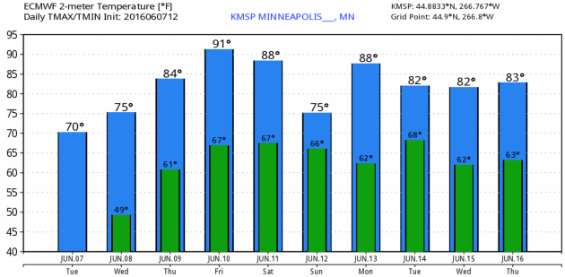
72 F. high temperature in St. Cloud Tuesday.
75 F. average high on June 7.
82 F. high on June 7, 2015.
June 8, 1972: 8 inches of rain falls in 7 hours at Madelia Township in Wantonwan County.
June 8, 1893:
Violent winds occur at Maple Plain from 1:30 to 2:15pm. A large frame
house was moved 8 feet from its foundation. Many barns and hay sheds
blown over by the wind. One barn was blown across Dutch Lake.
Cool & Comfortable Gives Way to Hot and SweatyWith
artificial intelligence will computers ever be able to tell stories,
with no human intervention? Will "Siri" whisper you own personalized
forecast?
An article in today's weather blog asks a rhetorical
question: with smart phone apps and computer models do we need weather
forecasters? Interesting question, and believe me, I'm hedging my bets.
At the risk of sounding defensive, we're still a long way from computers
providing perspective and context. That's true in news and sports, as
well.
But the future is unknowable; all meteorologists would be well advised to have a Plan B, just like everyone else.
Today
will be a tonic for the soul: sunny, upper 70s with comfortable dew
points. Soak it up. The approach of a sauna-like airmass sparks a few
T-storms
tonight into early
Thursday.
On the hot side of the front south winds lure a drippy dew point into
the mid-70s. With temperatures in the mid-90s the heat index
Friday could top 100F.
Models suggest slight relief
Saturday as surface winds turn to the east; T-storms
Monday, followed by a reprieve from the heat
on Tuesday.
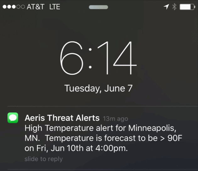
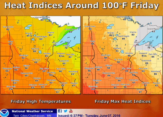
Dangerous Heat Index Friday?
As the old saying goes, it's not the heat, it's the humidity. Factoring
dew points well into the 70s an air temperature of 92 or 93F may feel
like 100 degrees by late afternoon Friday, based on NOAA guidance. The
definition of lake-worthy. Source: Aeris Enterprise.
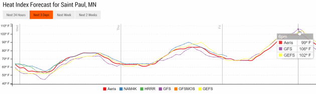
European Numbers.
ECMWF guidance shows low 90s Friday, which may wind up being a couple
degrees too cool. We'll see, but there's now little doubt we won't be
simmering, baking in the 90s Friday afternoon. A wind shift to the
northeast behind a feeble cool front provides slight relief Saturday
(upper 80s to near 90) with more cooling Sunday. Graphic: WeatherBell.
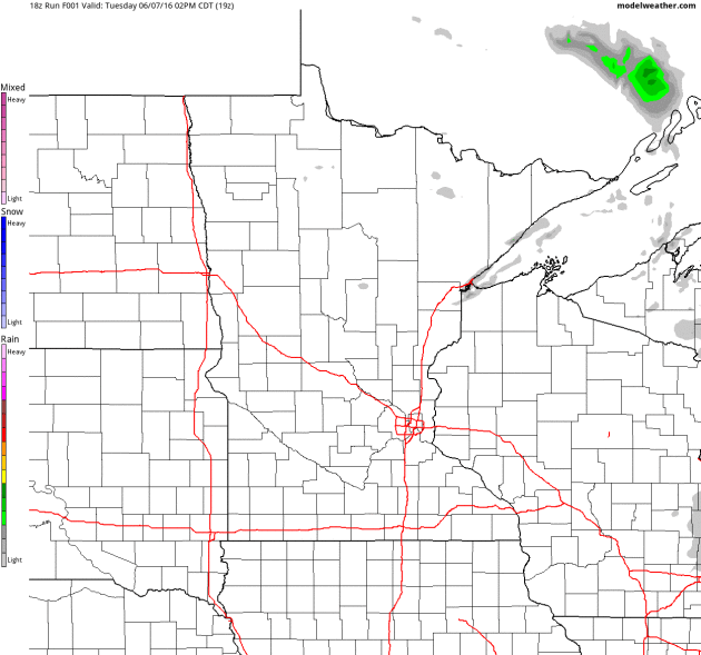
Nocturnal Thunderstorms.
Much of our rain in June comes at night, as low-level winds interact
with warm frontal boundaries, allowing convection to initiate after
dark. NOAA's 4 KM NAM model hints at a few T-storms tonight into early
Thursday, forming along the leading edge of our upcoming sauna. Source:
AerisWeather.
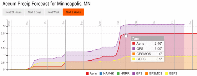
Significant Rain Early Next Week?
NOAA's models have been fairly consistent, predicting heavy showers and
T-storms Monday as (slightly) cooler air arrives from the Dakotas. Not
sure we'll pick up 3" of rain, but some 1"+ amounts seem plausible.
Source: Aeris Enterprise.
Next 2 Weeks: Mostly 80s.
Looking out 2 weeks I suspect 80s will be the rule, with a few days in
the 90s. By the 4th week of June the approach of cooler, Canadian air
may set up a pattern ripe for more frequent thunderstorms.
With iPhone and Computer Models, Do We Still Need Weather Forecasters?
I'm a bit biased, of course, but I would hope that there's always a
place for context, perspective and analysis, adding value above and
beyond what a computer can do, but who knows? Choosing which model to
believe is another ongoing challenge. Here's an excerpt from
Ars Technica: "...
But
most everybody has looked on their phone or some other device already.
So what am I going to do? Am I just going to rehash everything they
already know?” Many forecasters have been asking themselves this
question lately. Two technologies have converged to rapidly displace the
primary function of meteorologists. First are computers that are
generally better forecasters than humans. For most types of weather,
numerical weather prediction has superseded human forecast methods. And
secondly, thanks to the Internet and increasingly ubiquitous weather
apps on mobile devices, people have continuous, immediate access to
5-day, 7-day or 10-day forecasts. As technology drives automation and
machines take job after job once performed by humans, are meteorologists
next in line?..."
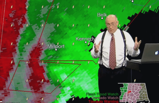
Photo credit: "
James Spann is Alabama's go-to meteorologist when the state's weather turns severe."
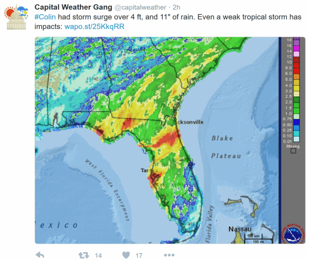
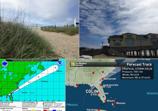
Tropical Storm Colin Produced 11 Inch Rains and a 4-Foot Storm Surge. The Washington Post's
Capital Weather Gang has a post-mortem on Colin: "
Despite
its lack of organization, it has produced impressive rainfall over the
Southeast. Parts of central and northern Florida, including the Tampa
Bay area, received 8-11 inches. Gainesville, Fla., which received 5.65
inches, had its 2nd wettest June day and 8th wettest day (of any month)
on record, according to the Southeast Regional Climate Center. The map below shows the estimated rainfall totals from Sunday to Tuesday morning..."
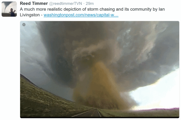
Attacking Storm Chasers Doesn't Accomplish Anything, And It's Often Misinformed. Here's an excerpt of a retort to a recent Eric Holthaus column from Ian Livington at
Capital Weather Gang: "..
.Chasers, ranks filled with tons of meteorologists, are generally smart folks and excellent risk assessors.
Observers should keep this in mind while continuing to judge us on
safety practices and choices when it comes to proximity to
tornadoes. The well-known chasers who were killed in 2013,
led by tornado researcher Tim Samaras, were giants of the field. But
they chased in a particularly dangerous way while trying to put probes
in front of tornadoes. Most chasers don’t chase that way. And very few
are out there with, as Holthaus calls it, “dollar signs in their eyes, as bystanders’ livelihoods are destroyed...”
The Storm and the Fury: 80 Vintage Photos of Hurricane Seasons Past. NOLA.com in New Orleans has a terrific photo essay; here's an excerpt: "
Bring
up the subject of hurricanes to most residents of South Louisiana, and
killer storms like Betsy in 1965, Camille in 1969 and
She-Who-Shall-Not-Be-Named in 2005 crop up consistently. But time and
again over the decades, the fortitude of locals has been tested by
storms that -- while maybe not as well remembered as those name-brand
milestones -- were still just as life-altering for many local residents.
Time and again, locals have proven equal to the task; Louisianians are
not prone to bowing down in difficult times..."
Photo credit: "
Hurricane Edith, 1971: A Baton Rouge service station found itself scrambled after Hurricane Edith blew though town." (J.W. Guillot / Times-Picayune archive)
An Above Average Season for Hurricanes in the Atlantic? NOAA is predicting an average summer and fall for tropical development, but
Penn State's ESSC forecast
calls for an above-average year for tropical cyclones in the Caribbean
and Atlantic basin. 3 named storms by June 6? That's the most on record
so early in the season, but is there a correlation with an above-average
hurricane season? Here's an excerpt: "
ESSC scientist Michael E. Mann, alumnus Michael Kozar, and researcher Sonya K. Miller
have released their seasonal prediction for the 2016 North Atlantic
hurricane season, which officially starts on June 1st and runs through
November 30th. The prediction is for 18.9 +/- 4.4 total named tropical
cyclones, which corresponds to a range between 14 and 24 storms with a
best estimate of 19 named storms. This prediction was made using the
statistical model of Kozar et al. (2012, see PDF here). This statistical model builds upon the past work of Sabbatelli and Mann (2007, see PDF here) by considering a larger number of climate predictors and including corrections for the historical undercount of events (see footnotes)..."
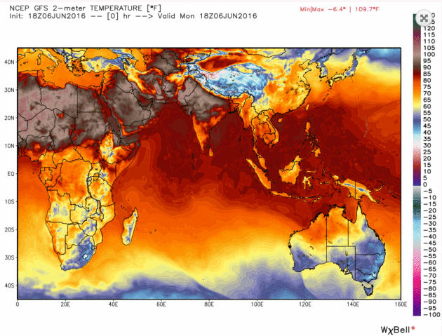
India's Crippling Heat Wave Continues With Temperatures Over 116F. TIME has the details; here's an excerpt: "
More
than 130 people have now died from the heat wave and resultant drought.
Despite the onset of the monsoon in several parts of the country, India
continues to reel under a brutal heat wave
that has now lasted more than two months and claimed dozens of lives.
On Monday, temperatures rose to more than 47°C (116.6°F) in the western
state of Rajasthan — which also recorded India’s hottest day ever at 123.8°F last month — the Press Trust of India reported..." (Map credit: WeatherBell).
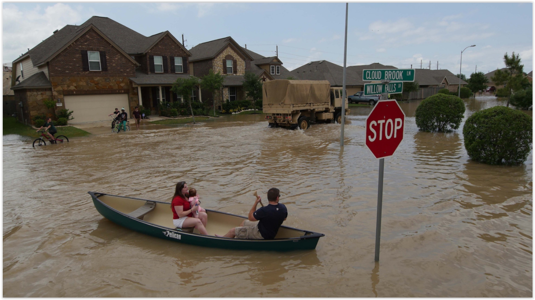
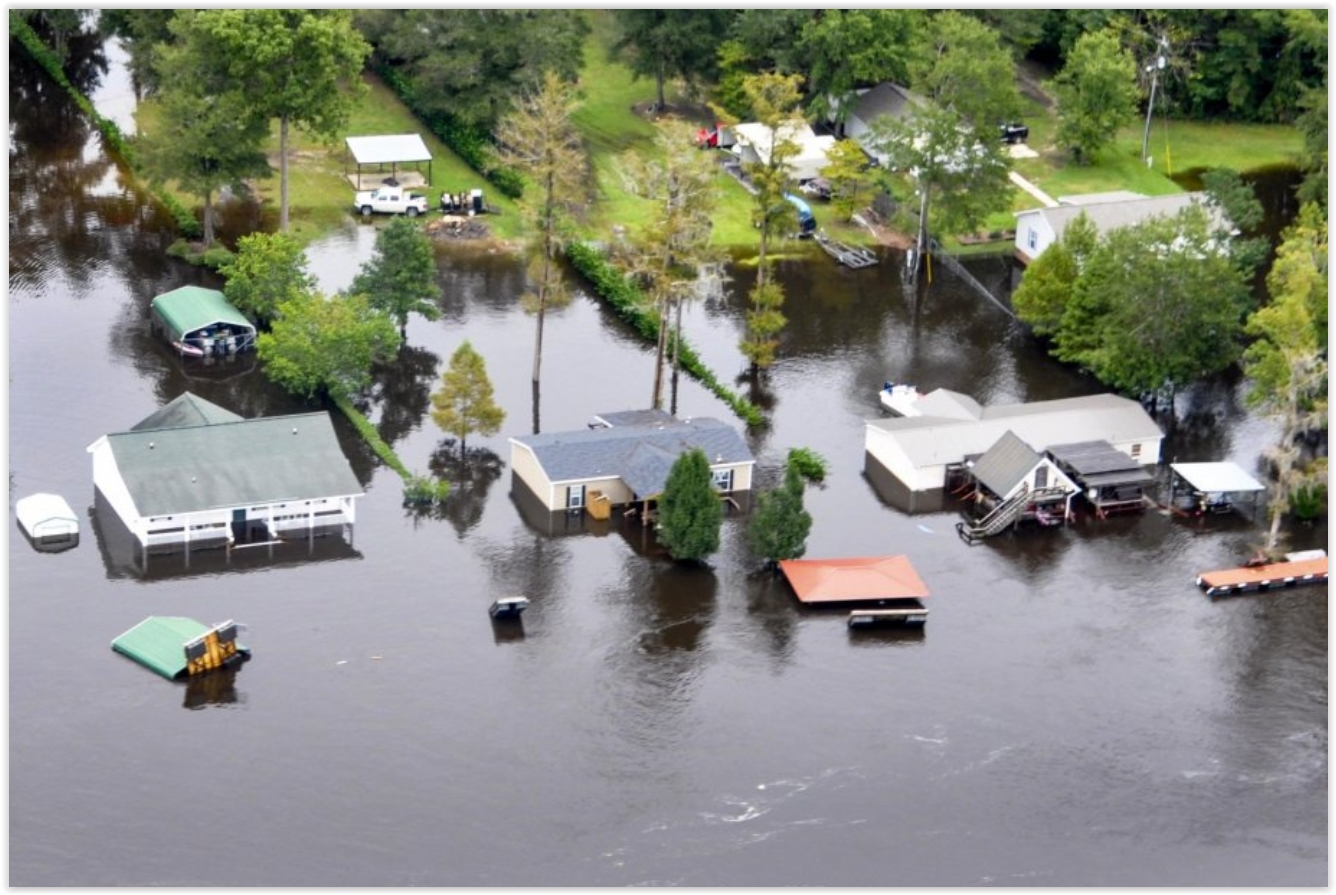 Editorial: Cities, Counties Must Deal With "New Normal" of Rain, Floods
. Here's an excerpt of an Op-Ed at the
Beaumont Enterprise in Texas: "...
Places
in Houston have had two "500-year floods" this spring. The city of
Brenham has already set a record for its wettest calendar year on
record. This week it got more than 19 inches of rain in 48 hours. That's
more than Los Angeles is supposed to get in an entire year. Half of our
entire state is under flash flood watch or warning. Keep in mind that
all of this has no connection with the "official" hurricane season,
which began this week. Our rainfall isn't cascading in from the Gulf of
Mexico. It's coming inland along the same patterns our parents and
grandparents dealt with - only more often, and heavier. After a while,
conditions like this aren't abnormal. They become the new normal, and we
have to start adjusting to them..." (File photo: U.S. Coast Guard).
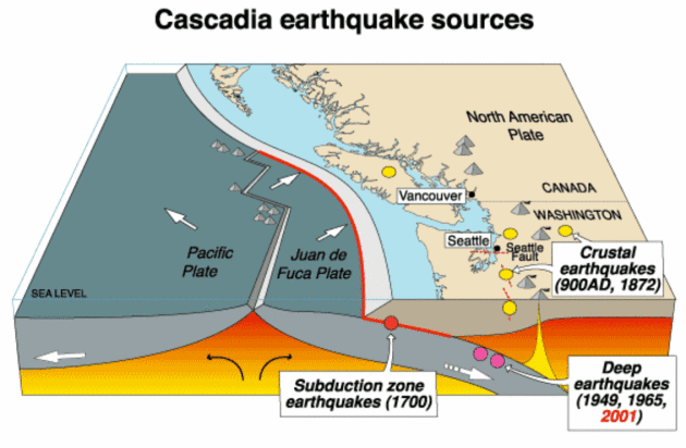
Massive Rehearsal Planned for Northwest Megaquake, Tsunami.
WCBD News 2 has the story - here's an excerpt: "
Imagine
a devastating earthquake and tsunami have cut off Pacific Northwest
coastal communities. Phone and internet service have collapsed. Ham
radio operators living on the stricken coast fire up their radios,
contact emergency managers and report on the magnitude of the disaster
so that no time is wasted in saving lives. This is the kind of scenario
that will be rehearsed during the second week of June in a massive
earthquake and tsunami readiness drill that has been developed by the
U.S. government, the military, and state and local emergency managers
over the past few years to test their readiness for what — when it
strikes — will likely be the nation’s worst natural calamity..."
Image credit: Wikipedia.
Cascadia, a State of Mind and a Megaquake. A story at
The Los Angeles Times caught my eye (with a son and daughter in law living in Seattle); here's an excerpt: "...
Yet
now, as the region booms with newcomers drawn to its technology
economy, Cascadia’s distinctiveness has become both indisputably clear
and darkly complicated. Its very existence is threatened with what
scientists say is a strong likelihood that, sooner or later, it will be
faced with the largest earthquake ever recorded in the United States. On
Tuesday, as many as 20,000 people across Washington, Oregon, California
and Idaho, mainly federal employees, will begin a four-day exercise
called “Cascadia Rising” — a trial run at responding to a massive
magnitude 9.0 quake on the Cascadia Subduction Zone off the northwest
coast near here, and the tsunami that would inevitably accompany it..."
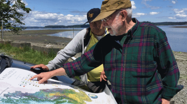
Photo credit: "
David
McCloskey, right, points out a feature of his map of Cascadia to a
vistor at Nisqually Reach, on the southern shore of Puget Sound." (William Yardley / Los Angeles Times).
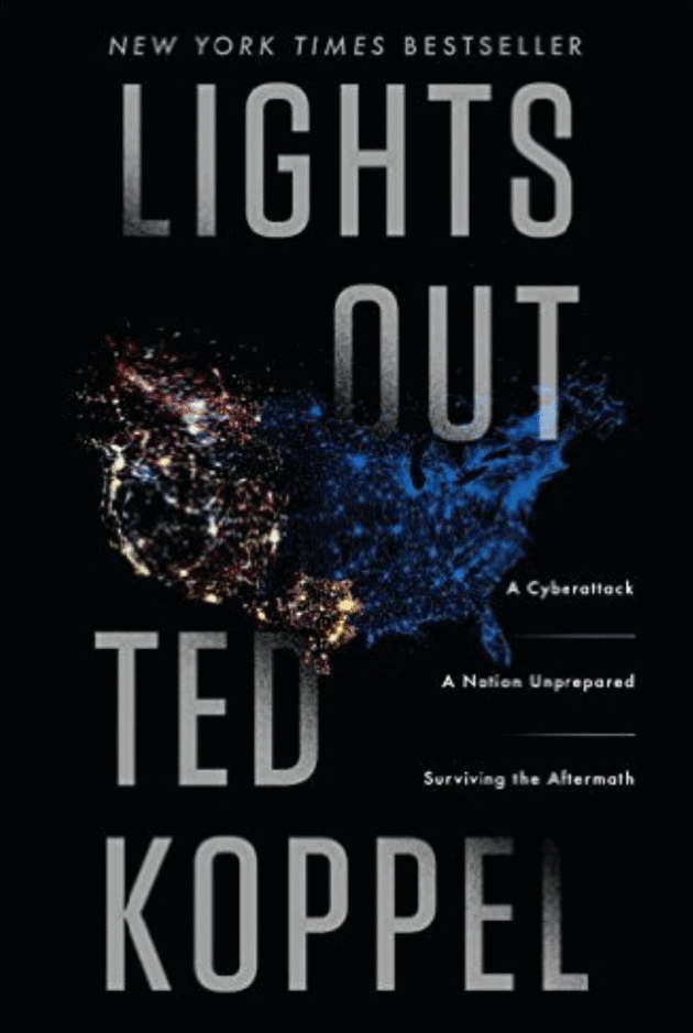
An Attack on the Grid? Power Execs Push Back on Koppel Claims.
USA TODAY has the article; here's an excerpt: "
Eight
months after veteran broadcast journalist Ted Koppel published a book
predicting a devastating cyberattack on the U.S. power grid, leaders of
the utility industry are sounding off over what they say is an
exaggerated claim. “We’re speaking out on it now because we think there
is an important story to tell,” Scott Aaronson, the managing director
for cyber and infrastructure security at the Edison Electric Institute,
said last week at a briefing for reporters..."
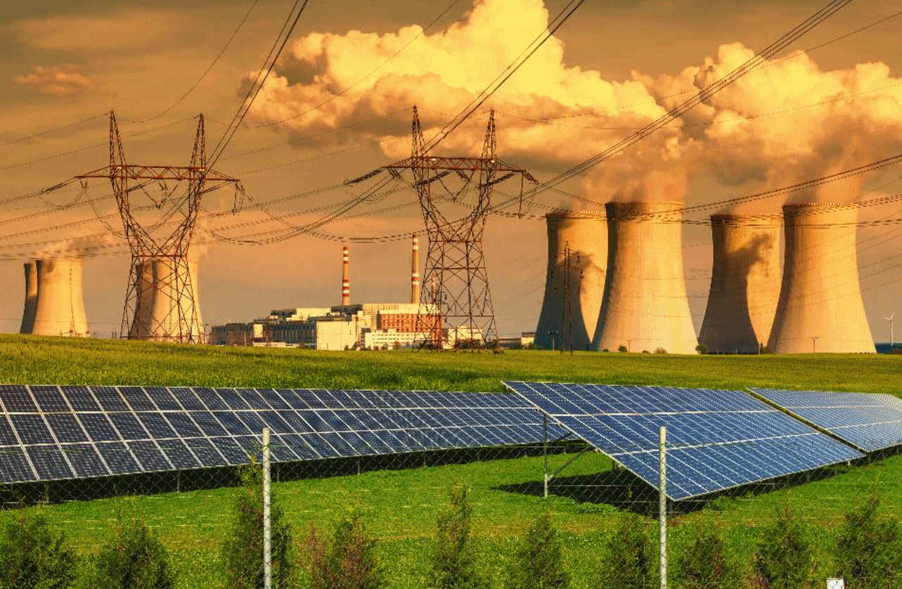 Steven Chu Criticizes Clean Power Plan for Neglecting Nuclear
.
Forbes has the article; here's the intro: "
Former
Energy Secretary Steven Chu doesn’t think energy storage can solve the
reliability problems of wind and solar quickly enough, he said Friday,
which led him to criticize the Environmental Protection Agency for
neglecting nuclear power in its Clean Power Plan. “Even though the Clean
Power Plan says we need nuclear and maintains the same ratio, they give
no credit for it,” Chu said during a debate at the Silicon Valley
Energy Summit hosted by Stanford University. “We should make a Clean
Power Plan that’s based on clean energy, not renewable energy...” (File image: Shutterstock).
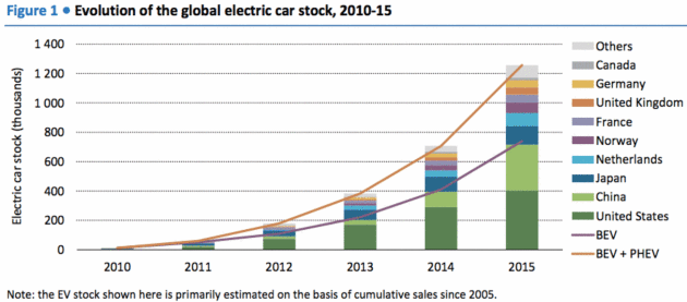
The Rapid Growth of Electric Cars Worldwide, in Four Charts.
Vox has the story - here's a clip: "...
The United States now has 400,000 electric vehicles on the road — a massive increase since 2010, though well short of Obama's goal of 1 million by 2015.
Meanwhile, China has become the world's largest market, overtaking the
US in annual sales last year. Is 1 million a lot? It depends how you
look at it. It's jaw-dropping growth given that there were only a few
hundred electric vehicles on the entire planet back in 2005. And the
total number of electric vehicles worldwide has tripled just since 2013..."
Chart credit:
IEA, Global EV Outlook 2016) "
BEV
= battery electric vehicles; PHEV = plug-in hybrid vehicles, which
typically have both an electric motor and a conventional engine."
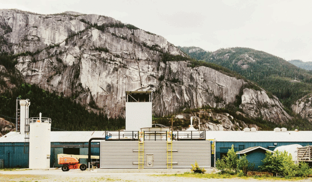
Go Inside an Industrial Plant That Sucks Carbon Dioxide Straight Out of the Air. MIT Technology Review has the story; here's the intro: "
Carbon
dioxide emissions must decrease to nearly zero by 2040 if global
warming by the end of this century is to be held to 2 C. But we may well
miss that target. A pilot plant started last fall at Squamish, British
Columbia, is testing a backup plan: sucking carbon dioxide directly out
of the air. Capturing ambient carbon dioxide is a tall order because,
for all the trouble it causes, the greenhouse gas makes up just .04
ercent of the air we breathe..."
Photo credit: "
This pilot plant can capture up to a ton of carbon dioxide per day."
 TODAY
TODAY: Sunny, still comfortable. Winds: S 5-10. High: 78
WEDNESDAY NIGHT: More clouds with a few T-storms possible. Low: 62THURSDAY: Early thunder, then sticky sunshine. Winds: SE 7-12. High: 83
FRIDAY: Very humid - sunny and stinking hot. T-storm risk late. Winds: S 10-15. Wake-up: 71. High: 93
SATURDAY: Partly sunny, very slight relief. Winds: NE 8-13. Wake-up: 73. High: 89
SUNDAY: Intervals of sticky sun, isolated T-storm. Winds: SE 10-15. Wake-up: 69. High: 82 (70s north of MSP)
MONDAY: More numerous T-storms, some heavy. Winds: S 10-20. Wake-up: 70. High: 81
TUESDAY: Clearing skies, less humid. Winds: NW 10-15. Wake-up: 64. High: 81
Climate Stories...
Tropical Storm Colin 2016. Here's an excerpt from
Climate Signals: "
Tropical
Storm Colin formed five days into the Atlantic hurricane season, just
as Tropical Storm Bonnie, which had arrived five days ahead of the
season's official start, dissipated. Colin marks the earliest arrival of
the third tropical storm in the Atlantic hurricane season, thanks to
unusually warm waters that have helped to fuel the early season storms.
Global warming has been found to increase the rainfall associated with
hurricanes. In addition seal level rise is elevating the storm surge
driven by hurricanes. There is also a significant risk that ocean
warming may be directly increasing hurricane intensity..." (Visible loop: WeatherTap).
That 70s Myth - Did Climate Science Really Call for a "Coming Ice Age?" Ars Technica has the story; here's the intro: "
One
of the undying, zombie-like arguments against climate change is that
you can’t trust climate scientists because they started out making doom
and gloom claims about global cooling in the 1970s. But this, along with
many other things comedian Dennis Miller has said
on late night talk shows, needn’t be taken seriously. By the time fears
of an ice age reached the public's attention, there was a long history
of concerns about warming. The idea that burning fossil fuels would warm
the planet can be traced back to an 1896 paper by Swedish scientist Svante Arrhenius. In the 1930s, Britain’s Guy Callendar concluded
that global warming was already underway. So it seems a bit odd that
anyone worried about cooling. What was really going on back in the
'70s—both in science and in the media?..."
Image credit:
Ravi Kochhar
Guest Post: Attributing Changes in Regional Rainfall to Human Activity.
Carbon Brief has the article; here's a link and excerpt: "...
But
simply waiting for models and observations to get better seems an
insufficient response to the climate changes that are already happening.
In our study, we discuss how new ways of identifying changes in
regional rainfall are beginning to show some success, even in the
presence of imperfect models and measurements. Growing scientific
understanding of the physical processes at play, together with
fine-detailed models, are allowing scientists to compare models and
observations in a way that can disentangle the thermodynamic and dynamic
aspects of the changes. This is a way forward to facilitate detection
in the face of uncertainty..." (File photo: Reuters, TPX Images).
The Great Barrier Reef: a Catastrophe Laid Bare.
The Guardian has the story; here's the intro: "
Australia’s
natural wonder is in mortal danger. Bleaching caused by climate change
has killed almost a quarter of its coral this year and many scientists
believe it could be too late for the rest. Using exclusive photographs
and new data, a Guardian special report investigates how the reef has
been devastated – and what can be done to save it..."
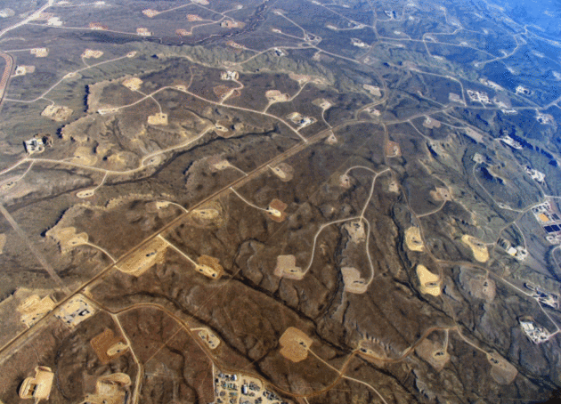
A Bridge to Nowhere. Is natural gas delaying the arrival of clean energy? Here's an excerpt from
ScienceLine: "
We’re wrapping an extra blanket around our planet that it doesn’t need,” climate scientist Katharine Hayhoe said on Twitter.
Hayhoe’s remark refers to the devastating effects of global warming and
paints this crisis in terms even children can understand, which is
helpful because global climate change will shape their lives. The earth
is on a steady road to a hotter future, and most people agree that
changing the way people generate and use energy could help ease the
burden of future impacts on our children..."
Photo credit: "
A massive network of roads connects oil and gas sites in Jonah Field, Wyo." Image used with permission from Bruce Gordon,
Ecoflight.
Why Isn't Anyone Lobbying for Climate Change? Senator Sheldon Whitehouse from Rhode Island has an Op-Ed at
Forbes; here's an excerpt: "...
I
asked them all, if you are not going to lobby on climate change, who do
you think will? If TechNet with its green energy firms, the lumber
industry with its climate challenges, and the property casualty
insurance industry paying for storm damage, all come to Washington and don’t even have climate change on their lobbying portfolio, what do they expect from Congress?
Washington’s dirty secret is that even the American companies that are
really good on sustainability put net zero effort into lobbying Congress
on climate change..."
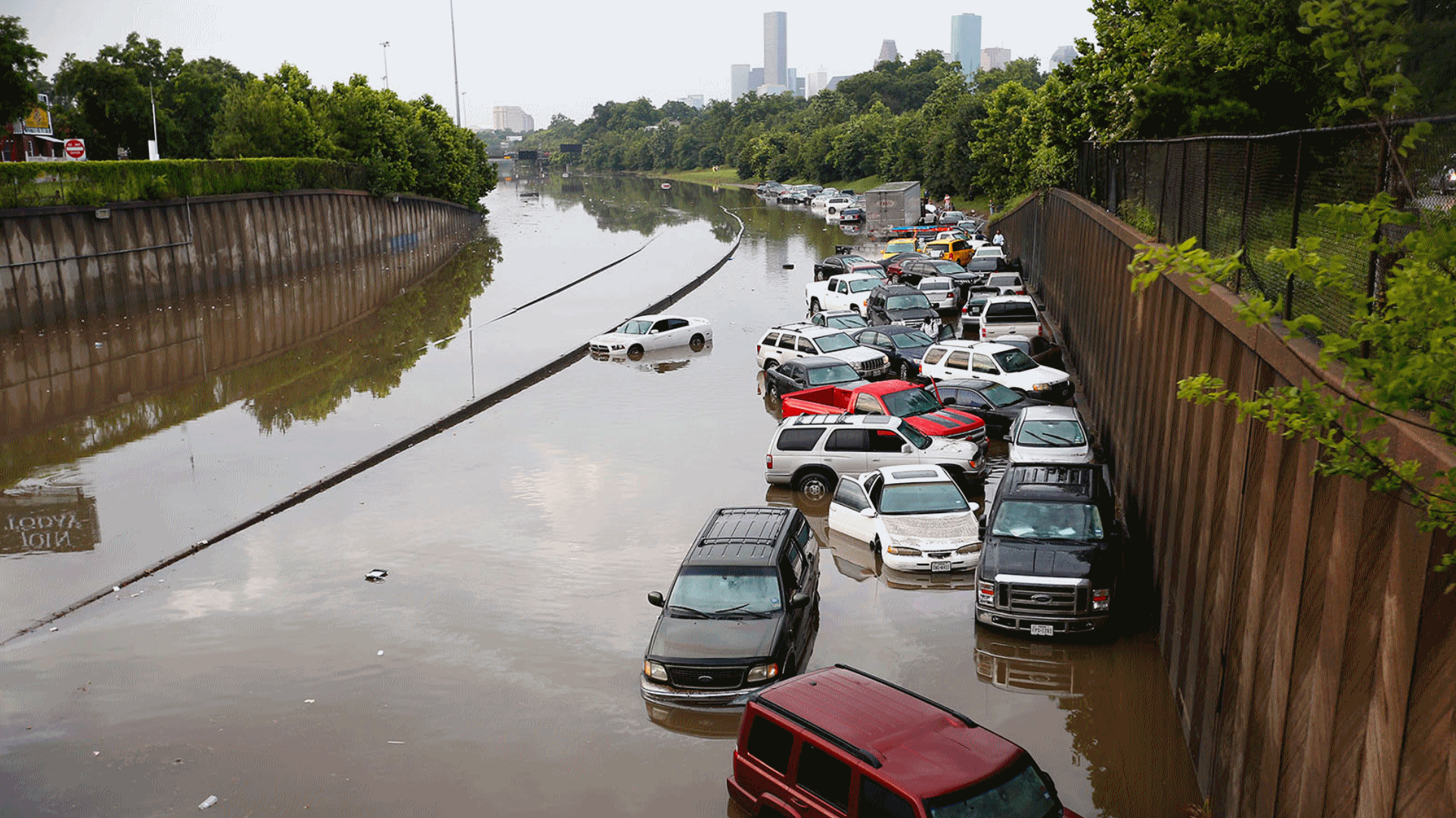 Historic Deluge Hits Texas. Houston, You Have a Problem.
 Here's an excerpt of an Eric Holthaus post at
Slate: "...
It’s
impossible to know exactly how much climate change factors into the
likelihood of these specific events, but it’s certain that it has.
Hotter hots, drier droughts, and heavier rains have long been predicted as a consequence of rising greenhouse gas levels that speed up our planet’s water cycle
and intensify many already extreme weather events. (The lingering
effects of a record-setting El Niño is also likely playing a part in the
recent Texas floods. And, it’s not just Texas: Over the past several
days, major floods have also hit Paris and other parts of Europe, Sri Lanka, and Ethiopia.) Texas has seen some of the most drastic change in the United States, with Houston registering a 167 percent increase in the biggest downpours since the 1950s..." (2015 file photo:
weather.com).
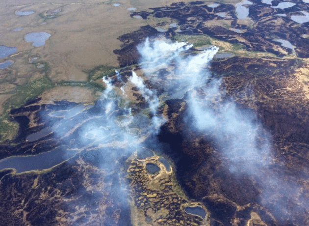
Alaska's Huge Climate Mystery - And Its Global Consequences. Chris Mooney reports for
The Washington Post; here's the intro: "
In
recent years, climate scientists have grown increasingly concerned
about a carbon problem in the far north. The fear is that with the
higher latitudes of the planet warming extremely rapidly,
that heat itself, and some of its consequences — such as raging
wildfires in northern forests — could unleash a climate disaster. Perennially frozen northern soils, known as permafrost, contain enormous amounts of carbon because the slow and cold chemistry of the Arctic makes them the repository of thousands of years of frozen plant remains..."
Photo credit: "
In
this June 2015 photo, smoke rises from the Bogus Creek Fire, one of two
fires then burning in the Yukon Delta National Wildlife Refuge in
southwest Alaska." (Matt Snyder/Alaska Division of Forestry via Associated Press).
Wisconsin Bees Dying Due To Insecticides, Global Warming and a Mite, Experts Say. PerfScience has an update: "...The
previous season, nearly 60% of Wisconsin honeybees died off during the
winter, a rate that was 4 times higher than the one considered
acceptable. In six of the past seven seasons, bee die-off rates have
climbed over 30%. According to the US Department of Agriculture (USDA)
data, 44% of bees died off across the nation this season. As per
experts, the die off is an outcome of using insecticides, global warming
and a mite. With the fall in the number of honeybees in Wisconsin, the
beekeepers should import new hives from throughout the country..."
 Meteorologist Don Paul: How I Learned Manmade Climate Change Is The Real Deal
. Here's an excerpt of Don's Op-Ed at
The Buffalo News: "...
When
climate models are run, they can be initialized with different data
sets and different levels of greenhouse gas in particular. To a model,
when these models are run with the carbon dioxide level of the year
approximately 1900 (around 297 ppm rather than the current 403 ppm), and
natural warming (not man-made) forces are maxed up, the globe would
have shown slight cooling through the end of the 20th century. Left to
so-called normal cyclic changes, even with other warming mechanisms in
nature pumped up, no other explanation can be found for warming that has
been ongoing at different rates over recent decades..."


No comments:
Post a Comment