SATURDAY: Partly to mostly cloudy, Wisconsin showers. Winds: E 5-10. High: 64
SATURDAY NIGHT: Partly cloudy. More clouds east, less clouds west. Low: 38
SUNDAY: Partly to mostly cloudy with showers threatening southeastern Minnesota. Winds: E 5-10. High: 65
MONDAY: More clouds, more showers across southeastern Minnesota and southern Wisconsin. Winds: NE 5-15. Low: 49. High: 68
TUESDAY: A mix of clouds and sun early. Better with more sun by late afternoon. Low: 45. High: 70
WEDNESDAY: Much nicer. Mild sunshine. Low: 48. High: 74
THURSDAY: Increasing clouds. Partly sunny, slight chance of a passing shower. Low: 50. High:70
FRIDAY: More sun, warmer south wind. Low: 45. High: 68
Image Credit: NASA
Photographed by the Expedition 28 crew aboard the International Space Station, this image shows the moon, the Earth's only natural satellite, at center with the limb of Earth near the bottom transitioning into the orange-colored troposphere, the lowest and most dense portion of the Earth's atmosphere.
Fall Color Peeping Tours
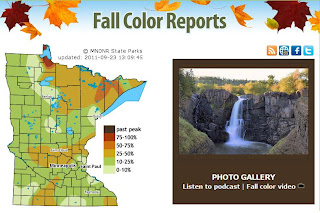
As we enter our first weekend of Fall, many may be on a mission to check out some of the latest color. The MN DNR runs a wonderful website with regularly updated information on how things are progressing around the state...
Current Fall Color Situation
The DNR is reporting peak color near Baudette and Lake of the Woods. It's getting near peak color in the Arrowhead and in pockets along MN's North Shore. Keep in mind, there are generally 2 different peak times near Lake Superior. The big lake tends to retain heat and keep the trees closer to the lake green a couple of weeks longer than when the inland locations typically peak. There is a beautiful array of oranges and reds inland as mostly sugar maples break down their chlorophyll, while there is more yellow near the lake as more Birch, Aspen/Poplars are present.
You can actually upload your pictures to the
A shameless plug here, but if you do happen to get some good shots
send them my way: tnelson@weathernation.net
I'd love to share them with all the blog readers here
Watch Why and How Seasons Change From Space
The season is changing because Earth is tilted. As it rotates around the Sun, the light reaches regions at a different angle for a longer or shorter time. This is how it looks from space:
Incredible Space Aurora Video
This is quite possibly the most compelling video I've ever seen. This was taken from the ISS during an Aurora event, what a view!
Don't You Hate Getting Cut Off?
You may have heard of that pesky "Cut-Off" low situation, stuck over the Great Lakes Region. This things is becoming a problem for folks stuck underneath it! Cool, cloudy and damp weather will continue rotating around it through early next week. The reason why these things are such a problem is because they tend not to move very quickly out of an area after they have detached themselves from the upper level winds. The jet stream is nowhere present to help push it off to the east.
Soggy Weekend Ahead
Unfortunately, folks stuck underneath the low with get several days of soggy weather. In fact, the 3 day rainfall forecast exceeds 2" in spots.
More Flooding Rain in the Northeast
Could it get any wetter? Geez, the Northeast can't seem to get rid of the rainfall, while folks in the Southern Plains need nearly 2ft. of rain to end the incredible drought. Flooding headlines have been issued in locations that may get another 1" to 3" of rain through the weekend on top of already saturated ground.
A Closer Look at New York
This is a look at the projected rainfall totals around New York and Long Island through early next week.
Tropical Trouble
Here's a look at the current tropical situation as it stood Friday evening. The National Hurricane Center was issuing advisories and forecasts on two named storms Hilary and Ophelia (one in the Pacific and another in the Atlantic). Hilary was a major category 4 hurricane in the Eastern Pacific and Ophelia was still a Tropical Storm churning towards Puerto Rico, but is veering north. There is also another disturbance just off the Cape Verde islands near Africa that has caught the attention of the NHC. This could also become our next named storm, Philippe
The Once-Endangered Gray Wolf is Now Prey
Since 1973, gray wolves have been on the endangered species list, a list of fish, wildlife and plants whose existence is threatened. But U.S. ranchers claim the wolf population is now large enough to sustain hunting and these ranchers were able to convince members of Congress to put a provision in the federal budget bill that took the wolves off the endangered species list.
Here's the full story from PBS
That's all for now thanks for checking in, have a great weekend!
Meteorologist Todd Nelson
Here's the full story from PBS
That's all for now thanks for checking in, have a great weekend!
Meteorologist Todd Nelson


No comments:
Post a Comment