Todd's SCTIMES Outlook for St. Cloud and all of Central Minnesota:
WEDNESDAY: Another clipper arrives late, scattered light snow showers or sprinkles late. Winds: WSW 5-15mph. High: 38
WEDNESDAY: Another clipper arrives late, scattered light snow showers or sprinkles late. Winds: WSW 5-15mph. High: 38
WEDNESDAY NIGHT: Mostly cloudy, chance of snow. Winds: NW 5-15mph Low: 23
THURSDAY: Mostly cloudy, chance of light snow. Winds: WNW 10-15mph. High: 35
FRIDAY: Mostly cloudy another shot of light snow. Chilly. Feels like February again. Winds: NW 10-20mph Low: 20. High: 29
SATURDAY: Chilly start, clouds thicken through the day and light snow develops late. Turning breezy. Winds: ESE 10-15mph Low: 12. High: 28.
SUNDAY: Cloudy, chance of snow. System to watch! Low: 18. High: 28.
MONDAY: Lingering snow, still breezy and colder. Low: 12. High: 20.
TUESDAY: Partly sunny. Below average temperatures. Low: 5. High: 17.
Snowfall Earlier This Week
Here is a snowfall analysis map of the snow event that we had earlier this week.
Actual Snow Totals
The reason why this is significant is because this became the 3rd largest snowfall of the winter season… a measly 2.7″ at the MSP Airport! Officially, the Twin Cities has seen 18″ of this season, which is good enough for the 5th least snowfall on record for a winter season. We still have a ways to go and there’s more snow in the forecast, so I don’t expect to see us hold this spot in the top 10 least snowfalls in a winter season.
Additional Snow in the Forecast
The 120hr forecast (thru AM Sunday) shows the potential for quite a bit of snow across the northern tier of the nation with the highest amounts falling across the Rockies.
Local Snow Forecast
This is a ways out yet, but take a look at the graphic below, not the spike in snow accumulations towards the end of the weekend/early next week. The GFS is still picking up on a larger storm then... stay tuned!
Prolonged Snow In the Mountain West
The National Weather Service has winter storm warnings in place through Thursday for high elevations that could get up to 18″ or more!
Upcoming Severe Potential
One of the Pacific Storms will drop into the Lower 48 by Wednesday afternoon and as it moves into the Plains, it will intensify causing concern for thunderstorms across the Deep South by Thursday afternoon/evening. Interestingly, the center of the storm will be near the Great Lakes, but the cold front will be significant enough to develop strong to severe storms as far south as the Gulf Coast.
Severe Potential Thursday Afternoon/Evening
The Storm Prediction Center has a SLIGHT RISK of severe weather already for areas shaded in orange. The best potential for severe storms (at this point) seems to be across parts of Louisiana, Mississippi and Alabama.
5 Day Precipitation Forecast
Note the blob heavier precipitation across the Southeast, this would be indicative of the thunderstorm activity that would be developing Thursday afternoon/evening.
Weather Water Cooler
Take a look at this picture from Oklahoma City yesterday courtesy Blake Brown, he caught this on the backside of a thunderstorm that rolled through the city on Monday afternoon. Pretty cool! See more HERE:
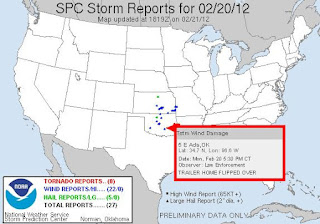
Deadly Storms in Oklahoma
Unfortunately, thunderstorms rolling through central Oklahoma produced strong winds that tipped over a mobile that claimed the life of one lady near Ada, OK.
Lunar Transit
This is pretty cool! This comes from NASA SDO:
“Today we were treated to a very special sight; the Moon came in between the SDO satellite and the Sun. For 1 hour and 41 minutes team SDO observed the Lunar Transit. This event only happens a few times a year but gives the SDO Team an opportunity to better understand the AIA instrument on SDO and give it a fine tune. This video shows today’s Lunar Eclipse in a variety of wavelengths the AIA instrument observes. Each wavelength shows us a different temperature and layer of the Sun, allowing us to study the Sun and its activities.“
Yosemite Falls Lava
Every February, Yosemite Falls turns to lava! This is a neat story from Yahoo News HERE:
“A window of time just opened in Yosemite National Park when nature photographers wait, as if for an eclipse, until the moment when the sun and earth align to create a fleeting phenomenon.“
Photo courtesy AP:
4.0 Magnitude Missouri Earthquake Early Today
“ST. LOUIS — Just days after the 200th anniversary of a series of massive earthquakes in southeast Missouri, residents woke up Tuesday to a rumbling reminder that they live in one of the continent’s most active seismic areas.”
Thanks for checking in on this Tuesday, have a great week and don't forget to check me out on Twitter @TNelsonWNTV
-Meteorologist Todd Nelson-


No comments:
Post a Comment