43 F. high temperature in St. Cloud Tuesday.
39 F. average high on March 17.
36 F. high on March 17, 2014.
29.1" snow so far this winter at St. Cloud.
54.4" snow last winter, to date.
March 18, 1968: The earliest tornado to hit Minnesota. No one was hurt when it hit Watonwan County.
Drought Potential
Welcome
to the 9th month in a row of drier than normal weather for most of
Minnesota. You have to go back to June, 2014 for a wetter than average
month, when a record 11.36 inches fell at MSP. I have fond memories of
vacuuming up muddy water in my basement. Since then the biggest, wettest
storms have taken a southerly detour.
Unless the pattern breaks,
and soon, we may be facing significant drought by mid-summer. It's too
early to panic but the more I stare at the maps the more concerned I
become.
And new research from Keith Harding and Peter Snyder at the University
of Minnesota suggests that a rapidly changing climate may be sparking
fewer summer storms over the Northern Hemisphere. More
days between rain events, but when it does rain it comes down in a
tropical deluge - much of that water running off and not soaking into
the soil. Fluke or trend? Stay tuned.
Now that we've seen a
freakishly early run of 60s and 70s, now that we're hopelessly spoiled,
40s and 50s into next week will feel like a cool front. You may even
need a jacket this weekend as highs struggle to reach 40F but subzero
nights are behind us now.
Any tournament storms? Are you kidding me?
It doesn't rain or snow here anymore.
* File photo above: Seth Perlman, AP.
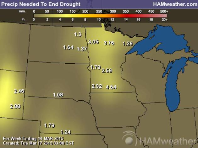
Growing Precipitation Deficit.
Most of Minnesota needs 2-4" of precipitation to pull out of a mild to
moderate drought. Frost is rapidly thawing out of the ground, and fields
and gardens are going to need a good soaking, after running a 9-month
precipitation deficit in the Twin Cities and much of greater Minnesota.
Map:
Ham Weather.
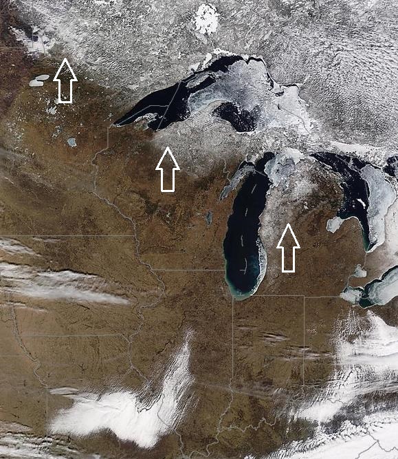
Shrinking Snowpack.
After 50s, 60s and even a few 70s much of last week I guess none of us
are terribly surprised by a lack of snow across all of Iowa, and most of
Minnesota and Wisconsin. Keep in mind the sun is now as high in the sky
as it was in late September. Even with air temperatures in the 40s it
feels pretty good out there. NASA Modis image:
University of Wisconsin.
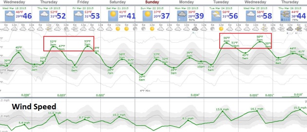
Couple of Chilly Dips.
Winter is over, although we'll see a few burps of Canadian air in the
coming weeks, the best chance of actually reaching for a jacket or
sweatshirt this weekend. Temperatures will still trend a few degrees
above average looking out 2 weeks or so. No more serious warm fronts in
sight; no storms either. Charting: Weatherspark.
A Dry, Seasonably Cool Extended Outlook.
Although I don't see any record warmth returning to the Upper Midwest,
Great Lakes or New England anytime soon, the pattern won't favor any
major rain or severe storm events either; no snow for Boston (!) either.
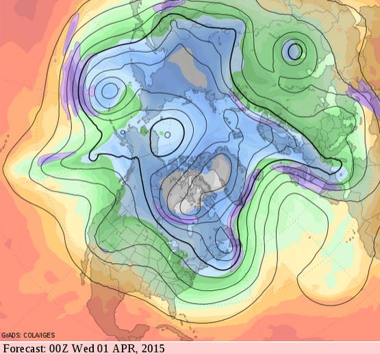
500 mb winds valid April Fool's Day are mainly zonal, implying 40s and
50s close to home. Grilling weather. Source: GrADS:COLA/IGES.
Five Weird Ways Cold Weather Affects Your Psyche. File this under TMI, but a story at
Yahoo News made me do a double-take. You've been warned: "...
Different types of creativity
can emerge when a person feels hot or cold, researchers found. In a
series of experiments, researchers found that people who were given a
heated therapeutic pad, a hot cup of tea or who were in a warm room were
better at creative drawing, categorizing objects and thinking of gift
ideas for others. But when they were cold, the participants were better
at recognizing metaphors, thinking of new pasta names and planning
abstract gift ideas..."

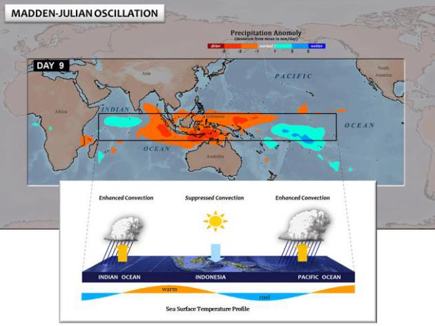
This Thing Called MJO Is Spitting Out Nasty Weather Across the Globe. El Nino, La Nina, Arctic Oscillations and now the MJO - it's a lot ot keep track of. Here's an excerpt from Bloomberg and
Yahoo Finance: "...
When
twin storms form like this, it’s often in response to a strong pulse in
the Madden-Julian Oscillation, Masters said. The MJO is a burst of
energy that moves through the atmosphere the way a ripple will run
through a snapped bed sheet. “This MJO will be one of the four strongest
going back to 1974,” Masters said. The same phenomenon will help
strengthen a high-pressure ridge near Alaska that will egg on a
low-pressure trough across central North America, dumping cold air into
the U.S. next week..."
File image credit:
UCAR.
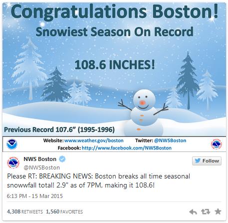
Boston Clinches Snowiest Season on Record Amid Winter of Superlatives.
The Washington Post has a story with some fascinating (and vaguely terrifying) weather nuggets and statistics; here's a clip: "...
The
city’s five-, seven-, 10-, 20-, 30- and 40-day snowfall records were
all broken within a couple of weeks. February became the snowiest month
on record after more than 45 inches fell in just two weeks. By the 28th,
the month’s total was 64.8 inches. Fastest six-foot snowfall record?
Broken — 18 days. Fastest 90-inch snowfall record? Broken — 23 days. To
top it off, it has been brutally cold this winter across the entire
Northeast..."
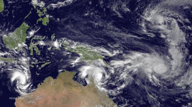
"Twin" Cyclones Could Jolt Weak El Nino.
Climate Central
ran this article on Friday, and I wanted to make sure I posted this,
showing the potential interplay between tropical cyclones and El Nino:
"...
Where the two cyclones come in is the winds associated with
an El Niño. Normally, the tropical Pacific features a pool of warm water
in the west and cooler temperatures to the east, where cold waters well
up from deep off the coast of South America. The prevailing easterly
trade winds keep this temperature pattern in place. When an El Niño
occurs, the winds slacken and can even reverse to blow from the west.
That sends the warm waters spilling eastward, the hallmark of an El
Niño. (When a La Niña occurs, the easterlies grow stronger and intensify
the east-west temperature contrast.)..."
Image credit from March 13 above: "
Cyclone
Pam (bottom right) and Tropical Depression 3, or Bavi (top right), are
two of four cyclones spinning in the oceans around Australia." Credit: NOAA.
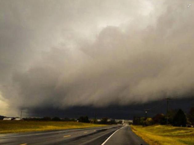
El Nino Can Predict Tornado Season's Severity. Another quiet tornado year? It's a little premature to wave that flag, but here's an excerpt of a story at
Live Science: "
This
year's El Niño may not only bring a bit of drought relief to parched
Western states, but also could deliver a quiet tornado season, a new
study finds. Much of the southeastern United States faces a lower risk
of tornadoes during El Niño years, the new research shows. The effects are strongest in Oklahoma, Arkansas and northern Texas..." (Photo credit above: Nashville National Weather Service).
* USA TODAY has another perspective on El Nino and 2015's tornado risk
here.
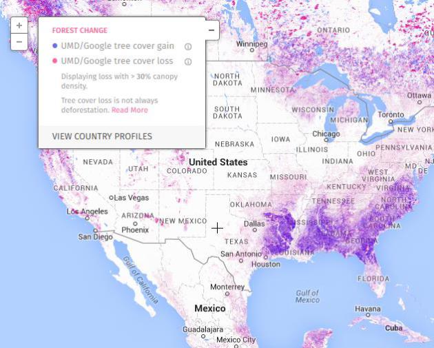
The Trees Have Eyes In The Sky.
Now you can track deforestation from the comfort of your family room.
Cutting down trees (a major carbon sink) adds to climate change, so
slowing or reversing the rate of deforestation is critical. Here's an
excerpt of a story at
onEarth: "...
Now if a tree falls in a forest and no one is around to hear it, someone will at least see it. That’s thanks to Global Forest Watch,
a free online tool that uses satellite images to track tree-cover loss
and gain across the globe in near real time. Anyone—governments,
companies, nonprofits, me, you—can use the site, upload data, or add
local observations to tell a deeper story..."

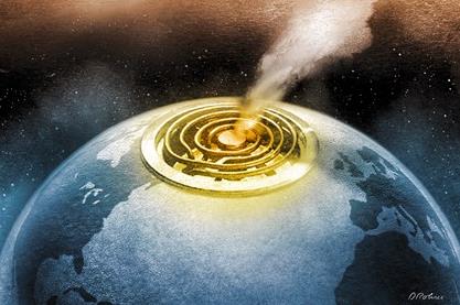
The Science of Near-Death Experiences.
Can science shed light on what happens when we die? Drug-induced
hallucinations or tantalizing glimpses of The Divine? Here's an excerpt
of an article at
The Atlantic: "..
.However,
Corcoran emphasized, the long-term effects of an NDE are as important
an indicator of whether you’ve had one as the experience itself. Many
people, she said, don’t realize for years that they’ve had an NDE, and
piece it together only after they notice the effects. These include
heightened sensitivity to light, sound, and certain chemicals; becoming
more caring and generous, sometimes to a fault; having trouble with
timekeeping and finances; feeling unconditional love for everyone, which
can be taxing on relatives and friends; and having a strange influence
on electrical equipment..."

Inside The Mad, Mad World of TripAdvisor. Do you use the site? If not odds are you will. We just love to share, the good, bad and ugly.
Outside Online has a great article focused on the site; here's an excerpt: "...
No
matter your destination, you will, at some point in your research,
visit TripAdvisor. The company, with the humble mantra “real hotel
reviews you can trust,” has become—on a rising tide of 200 million user
reviews and counting—a travel-industry Goliath, able to turn obscure
hotels into sold-out hot spots, carry new flocks of visitors on digital
word of mouth to quiet destinations, even rewrite the hospitality
standards of entire nations. For travelers the impact has been equally
profound..."
TODAY: Clouds increase during the day. Winds: SW 5-10. High: 45
WEDNESDAY NIGHT: Patchy clouds, passing sprinkle or flurry. Low: 30
THURSDAY: Clouds linger, above average temps. High: 48
FRIDAY: More clouds than sun, quiet. Wake-up: 34. High: near 50
SATURDAY: Sunny intervals, turning cooler. Wake-up: 29. High: 39
SUNDAY: Bright sun, light winds. Wake-up: 21. High: 40
MONDAY: Clouds increase, late shower? Wake-up: 24. High: 43
TUESDAY: Some sun, milder breeze kicks in. Wake-up: 26. High: 51
Climate Stories...
The Arctic's Climate Change is Messing With Our Weather. Here's
something I've been observing - and talking about quite publically for
the better part of 15 years. St. Thomas professor and climate scientist
John Abraham has the article at
The Guardian; here's an excerpt: "...
The
authors found that the summer zonal winds have weakened. The reason for
the weakening is that since the Arctic is warming faster than the rest
of the planet, the temperature difference between the Arctic and the
lower latitudes is getting smaller. It is this temperature difference
which maintains the wind speeds. The authors also found that eddy
kinetic energy is decreasing.
So what does all this mean? Well
two things. First, it means that there are either fewer or less intense
summer storms or a combination of both. But secondly, it means that
weather patterns can get “stuck”..."
Expert: American's Acceptance of Climate Change is Increasing. Here's a snippet of a story from the
University of Nebraska - Lincoln: "...
The
number of Americans who think climate change is not real continues to
decline but a well-funded and documented "denial industry" uses
strategies similar to those used to try to discredit the link between
tobacco and human health in which "doubt was the product," he said. One
of the reasons for doubt about global warming is that it is invisible.
"Carbon dioxide is pouring out of buildings, tailpipes and people's
mouths. We are standing in a volcano of carbon dioxide rising out of the
atmosphere," Leiserowitz said. "It is the same in every city but we
can't see it so it is out of sight, out of mind..."
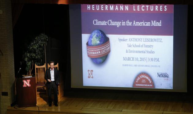
Photo credit above: "
Anthony
Leiserowitz, director of the Yale Project on Climate Change
Communication and research scientist in the School of Forestry and
Environmental Studies at Yale, speaks Tuesday, March 10, as part of the
Heuermann Lectures in the Institute of Agriculture and Natural Resources
at the University of Nebraska-Lincoln." (Craig Chandler/UNL Communications).
Can Science Find Common Ground With Evangelicals. The short answer appears to be yes. Here's an excerpt from
Scientific American: "...
God
created a sustainable world ... but he also told us to take care of
it," added Hescox, president and CEO of the Evangelical Environmental
Network. Hescox said he often quotes Genesis 2:15, where God orders Adam
to "care for" the Garden of Eden. If he's feeling more confrontational,
he may point to the Book of Isaiah, which includes the line "the earth
is polluted because of its inhabitants, who have transgressed laws [and]
violated statutes." "Human beings are accountable for how they care
about God's creation. ... To not tend to creation, to not steward it as a
shepherd, as a renter, a leaser of the land, is definitively
unbiblical, untheological," he said..."
The Melting of Antarctica Was Already Really Bad. It Just Got Worse. Alarmist hype? I sure hope so. Here's an excerpt of a story from Chris Mooney at
The Washington Post: "...
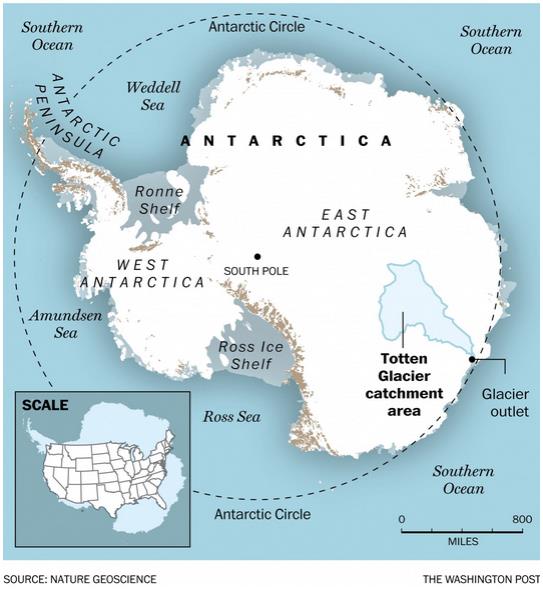
The findings about East Antarctica emerge from a new paper
just out in Nature Geoscience by an international team of scientists
representing the United States, Britain, France and Australia. They flew
a number of research flights over the Totten Glacier of East Antarctica
— the fastest-thinning sector of the world’s largest ice sheet — and
took a variety of measurements to try to figure out the reasons behind
its retreat. And the news wasn’t good: It appears that Totten, too, is
losing ice because warm ocean water is getting underneath it..."
Arctic Sea Ice Closes In On Record Low For The Winter. Andrew Freedman has an update at
Mashable; here's a clip: "
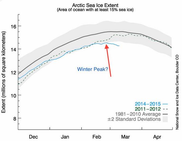
In
another sign of how swiftly global warming is reshaping the Arctic, it
is likely that scientists will declare a record low annual maximum sea
ice extent as early as Thursday. This means that the sea ice cover,
which has been in a steep decline in recent decades, built up to a
record low level this winter. The winter sea ice extent maximum usually
occurs in March, but based on a recent decline in sea ice since the
start of the month, as well as ocean temperatures in areas that
currently lack sea ice cover, scientists are likely to declare that the
maximum actually occurred on or about February 25..."
Image credit: "
Arctic
sea ice extent for 2015 compared to other recent years and the recent
average. The likely winter peak indicated with arrow." National Snow and Ice Data Center and Mashable.
Baked Alaska.
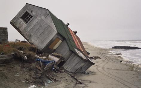
The warming taking place in Alaska is nothing short of breathtaking,
with implications across the board. Here's an excerpt of an eye-opening
piece from Slate and
Mother Jones, which reports the last frontier's weather is broken: "...
But
it's unclear how long that will be possible. Alaska is heating up at
twice the rate of the rest of the country—a canary in our climate coal
mine. A new report
shows that warming in Alaska, along with the rest of the Arctic, is
accelerating as the loss of snow and ice cover begins to set off a
feedback loop of further warming. Warming in wintertime has been the
most dramatic—more than 6 degrees in the past 50 years. And this is just a fraction of the warming that's expected to come over just the next few decades...." (File image: Media Matters).
Scientists Talk About Why Climate Change Matters To Them.
Beyond the science, the data and statistics it all comes down to caring
for your kids, your grandkids, and the various messes we're leaving to
future generations to clean up. Here's an excerpt from
EcoWatch: "...
In an unprecedented collaboration between climate scientists, advocacy organizations and the public, More Than Scientists, which
launched today, sources the real life stories and personal views of
scientists on the frontlines of climate research. In a series of short
videos, scientists who work in climate-related disciplines don’t spew
facts and figures, but rather the personal concerns that those facts and
figures have led them to. They talk about the potential impact of climate change on their families, their communities and the environment, with the hope that this will spur people into taking action..."
Forget Global Warming and Climate Change; Call it "Climate Disruption". I still like the term climate volatility, but disruption works too. Here's a clip from a story at
Forbes: "...
We
expect to see changes in precipitation patterns and sea-level rise that
will have much greater impact to humans and our animal friends and
biodiversity than the temperature alone. As a matter of fact, we’re
pretty sure that we’re going to see increased weather extremes. Perhaps
you’re noticing some of them as well.” Climate disruption edges closer
to a term originally used by climate scientists in the earliest studies
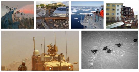
of human impacts on climate—inadvertent climate modification—with perhaps slightly more elegance..." (File image: Department of Defense).
Can The World Get Richer Forever?
Growth requires energy, energy requires fossil fuels, or at least it
has up until fairly recently. New, cleaner, renewable, sustainable
options may disrupt this equation - at least that's the hope. Here's an
excerpt from a story at
The BBC: "...
Journalists
are complicit in this. We frequently describe rapid growth as "robust".
Slower growth is "anaemic" and an economy in recession is often
portrayed as "sick" or "ailing". Yet there's a problem here. We live on a
finite planet, but growth is exponential. So an annual increase in
gross domestic product (GDP) of 3% might not sound like much - but it
means an economy will double in size every 23 years..."
Obama Guarantees GOP Will Change on Climate.
TheHill has an interesting story - here's a clip: "...
The
president said congressional committees on the environment typically
consist of lawmakers from areas that rely heavily on fossil fuels and
that some lawmakers are "shills for the oil companies and the fossil
fuel industry." Obama added that he doesn't fault average Americans for
putting their wallets in front of the bigger picture on climate. "If you
poll folks, they are concerned about climate change, but they are more
concerned about gas prices," he said..."
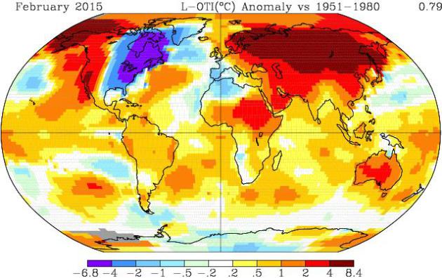
NASA: February 2015 Was Second Warmest After 1998. The site,
reportingclimatescience.com, has an update; here's an excerpt: "...
Significantly
warmer than usual weather in parts of the northern hemisphere pushed up
global average temperatures last month, according to data released by
US space agency NASA. The global average surface temperature in February
2015 was +0.79oC above the long term average, according to NASA. This was 0.04oC warmer than the January and makes the month the second warmest February – behind 1998 (+0.86oC) - on the records maintained by the agency which date back to 1880..."
Image credit above: "NASA
GISS global surface temperature anomaly map for February 2015 showing
particularly high anomalies across northern Europe, Eurasia, China and
the Arctic. Note: Gray areas signify missing data. Note: Ocean data are
not used over land nor within 100km of a reporting land station." Courtesy: NASA.
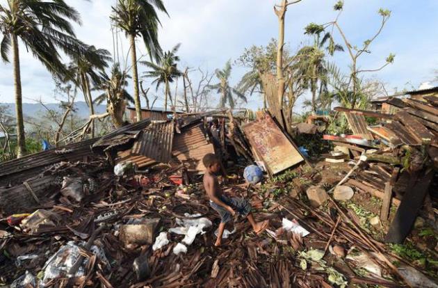
Cyclone Pam: Vanuatu's President Blames Climate Change for Extreme Weather.
Warmer oceans may be fueling more extreme hurricanes (called typhoons
in the western Pacific and cyclones near Australia and India); sea level
is rising, compounding storm surge damage. Here's an excerpt from
The Guardian: "...
For
leaders of low-lying island atolls, the hazards of global warming
affect our people in different ways, and it is a catastrophe that
impinges on our rights … and our survival into the future.” The cyclone
caused major infrastructure damage to the island nation with up to 90%
of structures believed to have been levelled in Efate. Winds were
estimated to have reached 250km/h, according to
the United Nations Office for the Coordination of Humanitarian Affairs.
The damage is also extensive in the capital, Port Vila, which one Unicef officer said looked like it had been “hit by a bomb”..."
Photo credit above: "
Samuel,
only his first name given, kicks a ball through the ruins of their
family home as his father, Phillip, at back, picks through the debris in
Port Vila, Vanuatu in the aftermath of Cyclone Pam Monday,
March 16, 2015. Vanuatu's President Baldwin Lonsdale said Monday that
the cyclone that hammered the tiny South Pacific archipelago over the
weekend was a "monster" that has destroyed or damaged 90 percent of the
buildings in the capital and has forced the nation to start anew." (AP Photo/Dave Hunt, Pool)
Cyclone Pam: Untangling The Complex Science on Tropical Storms and Climate Change. Here's a clip from an informative and timely story at
Carbon Brief: "...
Tropical storms derive energy from the warmth of the ocean and convert it into wind strength. While strong storms aren't unusual for the region, Cyclone Pam was exceptional. Prof Kevin Trenberth, expert in climate change and extreme weather at the US National Centre for Atmospheric Research, tells Carbon Brief:
"In the large area around Vanuatu the sea surface temperatures were one
to two degrees Celsius above normal … So the atmosphere all around
there has some 10 to 20% more moisture in it than a comparable storm in
the 1970s would have had..."
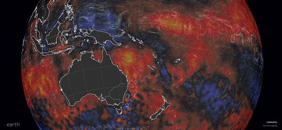
Image credit above: "
Sea
surface temperature anomaly for 16th March 2015, compared to 1981-2011
daily average. Blue is lower than average, red is higher." Images courtesy of Cameron Beccario via
earth.nullschool.net
Are Extreme Hurricanes, Typhoons and Cyclones Becoming More Extreme Over Time?
The answer appears to be yes, although the science is still emerging.
Fewer storms, but the big storms are hitting with greater ferocity.
Here's a link to an
interesting paper at the Journal of Climate, courtesy of the University of Wisconsin.
Exponential Increase in a Hurricane's Destructive Power. Here's a nugget from the
University of Rhode Island that made me do a triple-take, something many (meteorologists) don't even realize - or communicate: "...
An
often-misunderstood aspect of hurricane winds is the potential for
increased damage as wind speeds increase. The forces against structures
do not increase linearly, they increase exponentially (power of 3), and
as wind speed increases. A 241 kph (150 mph) wind is 20% stronger than a
201 kph (125 mph) wind. However, the destructive power of a 241 kph
(150 mph) wind compared to a 201 kph (125 mph) wind is actually 73%
greater..."







No comments:
Post a Comment