88 F. high in St. Cloud Sunday.
82 F. average high on July 26.
88 F. high on July 26, 2014.
July 27, 1910: Giant hailstones in Todd and Wadena Counties. One stone weighed in at 5 pounds
Hint of Dog DaysIt's
easy for meteorologists to get caught up in our models, minutia and
Doppler-babble and miss the forest through the trees. "We haven't seen
many perfect days this summer" my wife mentioned, staring up at
Sunday's
cloudless sky. "You know, where it's sunny and hot the entire day. No
clouds, no storms?" She had a point. I tried to explain how a southward
shift in the jet stream, a nagging northwest wind flow aloft, has keep
an unsettled, thundery boundary hundreds of miles farther south than
normal, over MSP. That's a result of a stalled ridge of record heat
straddling the western USA.
At which point she politely changed the subject.
The
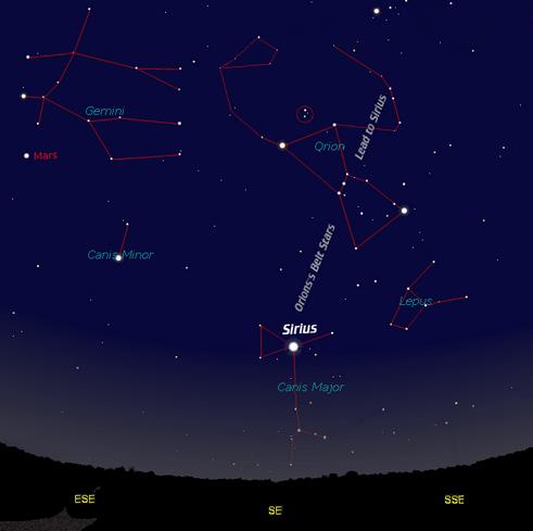
Dog Days are named after Sirius, the brightest star in the nighttime
sky. Ancient Greeks believed Sirius rising in the east added to the heat
of the sun, making it even hotter this time of year.
Highs flirt with 90F this afternoon; a squall line of strong to severe T-storms may keep us out of the 90s
Tuesday,
but a dew point in the mid-70s will leave us with a "breath-taking"
day. A puff of faint Canadian relief arrives midweek, a second cooler,
fresher front sweeping south of the border next weekend. More 3-star
blue-ribbon days ahead.
* Image credit:
astronomy.org.
Dry Monday - Stormy Tuesday.
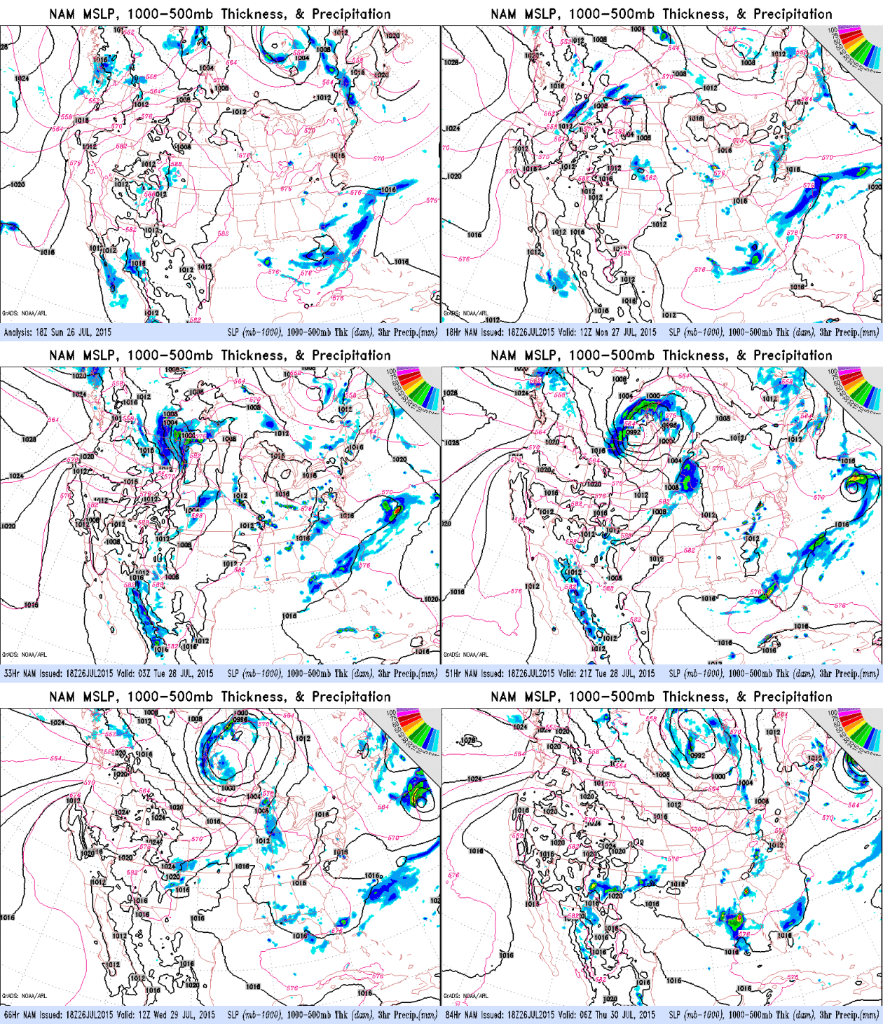
Most of the models bring a line of strong T-storms across the state of
Minnesota Tuesday morning, with enough residual cloudiness to keep
temperatures in the upper 80s to near 90F, not as hot as we would be
without morning convection. Behind Tuesday's front - a surge of drier,
slightly cooler air with a noticeable dip in humidity.
Tuesday: Wettest Day of the Week.
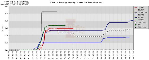
The 00z NAM predicts .64" of rain Tuesday morning, which is an average.
Some towns will see more, others less, but I don't think we're looking
at a flash flood scenario tomorrow morning. Source: Iowa State.
 Moderately Wet Next 7 Days
.
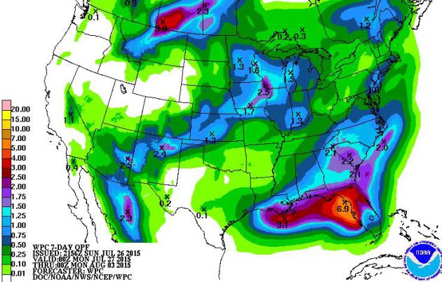
NOAA model guidance prints out 1-3" amounts from near La Crosse to the
Quad Cities and Des Moines, as much as 6-8" for Florida, where there are
still hints of a tropical disturbance forming by the end of this week.
Much of Minnesota will pick up .5" to 1.5" by next Sunday.
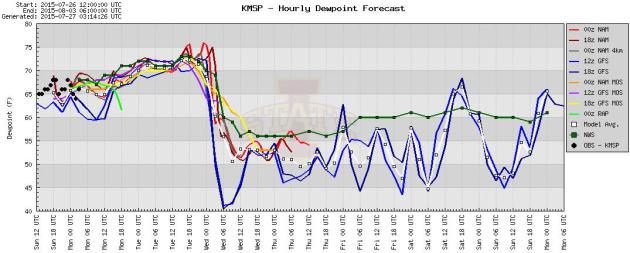
Midweek Dew Point Dip.
Today will be uncomfortable - Tuesday should border on beastly-humid
with dew points rising in the 70s. And then a frontal passage turns
winds to the northwest Wednesday and dew point drop into the upper 50s
to near 60 the latter half of the week.
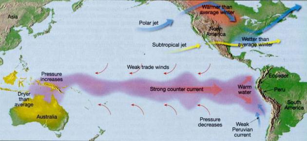
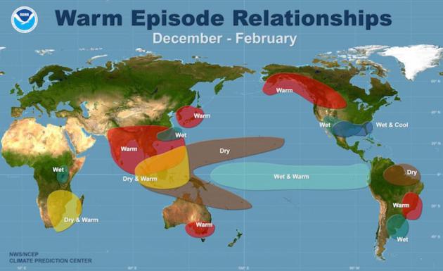
El Nino Likely To Spur More Floods Throughout USA This Fall.
The Pacific Ocean is warm and energized, helping to spawn a near-record
number of hurricanes and typhoons. Some of that added energy may
manifest itself into a wetter pattern into the winter months, especially
southern USA from California to Atlanta and the east coast. Here's an
excerpt from
wtsp.com in Tampa: "...
Plus,
this year's El Niño is forecast to be a record-setting one by the
National Weather Service. An El Niño is a weather phenomenon marked by
warmer Pacific Ocean temperatures that produces severe weather
throughout the world. A warmer ocean transfers more water vapor into the
air which, when shaken loose by storms, results in heavier and more
concentrated precipitation. Last week's eastern Kentucky flood along
with those that hit Texas in late May and June — the most devastating in
the state's history — may foreshadow what's to come in certain parts of
the country..." (Image credit
here).
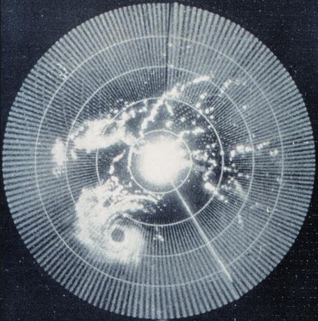
An Inconvenient Smudge.
Radar technology gave the allied powers a distinct advantage during
World War II. Tracking enemy planes and ships in real time provided a
military edge. Around 1941 British radar operators noticed irritating
smudges on their screens; interference that made it harder to pick out
legitimate targets. It quickly dawned on them that they were witnessing
rain shafts, and the race was on to perfect "Radio Detection And
Ranging" or radar for short. Today's sophisticated "dual-polarization"
Doppler radars not only see wind circulations within storms but can
signal precipitation type, even detect clouds of debris thrown up by a
tornado on the ground. Satellites, transistors, the Internet, moon walks
- you can make a strong argument that conflict is the mother of
invention. (File radar image above courtesy of
Wikipedia.)
Summer Temperatures, To Date. Temperatures have been average to slightly below average, as of July 23. Here are a few bullet points that caught my eye:
* Average temperature so far this summer (June 1 - July 23) is 70.8°
*
According to my calculations, taking the average temperatures for the
same period from 1981-2010 and averaging them, that average is 70.9°. So
it would appear we are about on average.
* Warmest
June 1 - July 23 on record is 77.1° in 1933. Coolest June 1 - July 23:
64.6° in 1915. (Random? Yes. But I had the numbers.)
* June was 0.8 degrees above average, with an average monthly temperature of 69.7.
* Warmest low temperature: 68 on July 18. (So no 70+ lows so far this summer).
* Two 90 degrees so far this summer.
Summer temperature data courtesy of AerisWeather meteorologist D.J. Kayer.
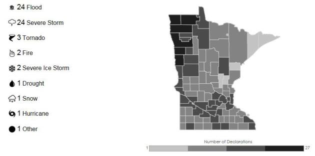
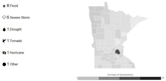
59 Weather-Related Disaster Declarations in Minnesota since 1953.
It's a dead heat between flooding and severe storms; ironic - based on
our Nanook reputation - that only one disaster declaration was
snow-related. 59 compares with 44 weather-related disaster declarations
in Wisconsin, 59 in Iowa, 119 in Florida and 247 separate disaster
declarations in Texas. The higher risk in the Red River Valley is a
function of enhanced spring flooding risk. If only the Red River didn't
flow north. More details at
FEMA.gov.
June: Peak Month for Weather-Related Disasters.
This is consistent with other statistics I've seen for Minnesota; the
atmosphere most unstable, volatile (and moist) in June, capable of
supporting severe storms and tornadoes.
How Disaster-Prone Is Your County? Hennepin County has experienced 15 weather-related disaster declarations since 1953.
Click here to drill down to Minnesota, then your home county.
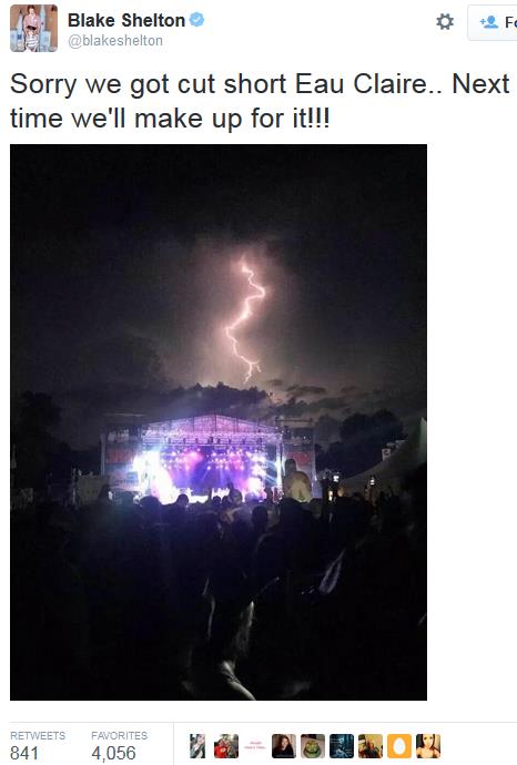
Close Call in Eau Claire. A friend of mine sent me more information about the
Blake Shelton
performance at Country Jam in Eau Claire Friday evening. This is still
one of our worst-case scenarios, the kind of dilemma that keeps us up at
night. Tens of thousands of people watching a concert or watching a
sporting event - how do you move them all quickly and safely to shelter?
In some cases it may not be possible. That's why it's good to have a
radar app or two on your smartphone and keep an eye on it yourself.
Don't put your safety - or fate - into anyone else's hands.
"
Friday
night was a close call with the weather. We took our daughter and a
friend to Country Jam. By the time the headliner, Blake Shelton, took
the stage, a storm was moving into Chippewa County to the north. It was
quite the lightning show, but it looked like the storm would pass 15
miles to the north of the concert site. When a tornado warning was
issued within the county, local emergency managers decided to shut down
the concert and send approximately 25,000 home..."
How This El Nino Is And Isn't Like 1997.
Just like no two storms are identical no two El Nino warming phases are
carbon copies. The stronger the warming signal in the Pacific, the
greater the odds of a turn to wetter weather, even flooding for
California by the winter months. Here's a snippet of a good explainer at
Climate Central: "...
We
think that the strength of [El Niño] is important,” L’Heureux said, but
the exact strength it achieves is no guarantee of impacts similar to
1997, “and that’s simply because there’s other stuff going on,” she
said. “El Niño is not the only ball game in town.” So where does that
leave us in terms of looking ahead to what El Niño might bring this
winter? We have an event that is looking more and more robust
(when comparing June 2015 to June 1997, the broad ocean temperature
patterns are very similar) and forecasting models are in pretty good
agreement that that event will strengthen as we head towards winter and
El Niño’s typical peak. But exactly when it will peak and what its final
strength will be is still uncertain. Even more uncertain is what those
other influences on U.S. weather will be..."
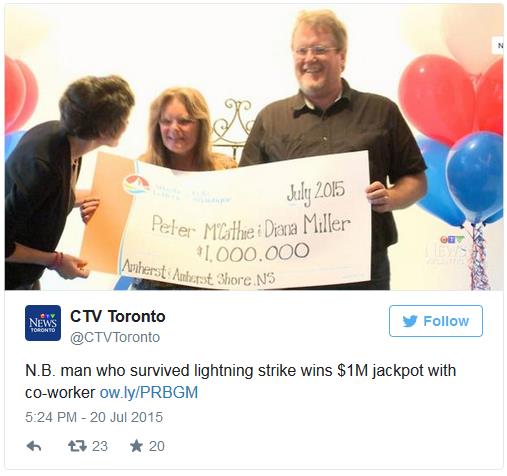
Canadian Lightning Strike Survivor Wins Lotto. No way. CTV News and
TIME have the mind-boggling details; here's the intro: "
The
odds that Peter McCathie would be struck by lightning and win the lotto
are approximately 1 in 2.6 trillion Peter McCathie quite literally
defied the odds. The Canadian man, who was previously struck by lightning when he was 14, collected his Atlantic Lottery winnings on Monday..."
TODAY: Hot sun, sticky. Feels like mid-90s. High: 89
MONDAY NIGHT: Muggy, few T-storms possible late. Low: 75
TUESDAY: Strong T-storms; feels like 95-100F. Dew point: 75. High: 91
WEDNESDAY: Sunny, breezy, less humid. Wake-up: 69. High: 84
THURSDAY: Warm sunshine. Dew point: 63. Wake-up: 64. High: 87
FRIDAY: Sunny, bordering on hot again. Wake-up: 67. High: 89
SATURDAY: Muggy, few pop-up T-storms. Wake-up: 70. High: 87
SUNDAY: Blue sky, another drop in humidity. Wake-up: 66. High: 82
Climate Stories....
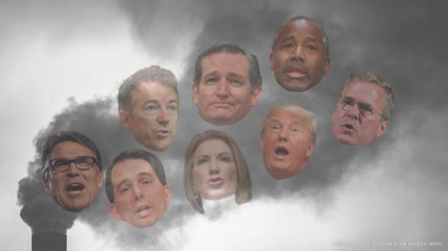
The Most (And Least) Extreme Republican Presidential Candidates on Climate Change. Thank God for Lindsey Graham, who sounds almost reasonable compared to the other candidates. Here's an excerpt from
ThinkProgress: "...After he announced his presidential run, however, Graham seemed to
take up the banner of climate change again.
“If I’m president of the United States, we’re going to address climate
change, CO2 emissions in a business-friendly way,” he told CNN. He said
people should ask other candidates, “What is the environmental policy of
the Republican party?” “When I ask that question, I get a blank stare.”
While addressing emissions in a business-friendly way could mean any
number of things, a Graham presidency would not start out the gate
trying to put President Obama’s climate agenda into reverse..."
Image credit above: AP photos/graphic via Patrick Smith.
Investors Could Lose $4.2 Trillion Because of Climate Change, Report Warns. Here's the intro to a story at
The Guardian: "
Private
investors stand to lose $4.2tn (£2.7tn) on the value of their holdings
from the impact of climate change by 2100 even if global warming is held
at plus 2C, a report from the Economist Intelligence Unit (EIU) has
warned. If firm action is not taken at the forthcoming climate change
talks in Paris and the Earth’s temperature warms by a further 5C then
investors are facing losses of almost $7tn at today’s prices, new
research shows..."
Photo credit above: "
The future is grim for private holdings in fossil fuel companies over action – or inaction – around climate change." Photograph: Daniel Reinhardt/EPA.
Jeb Bush Calls for End To Fossil Fuel Subsidies. Here's a clip from an update at
NationalJournal: "eb Bush wants to get rid of tax credits for the oil and gas industry. "
I
think we should phase out, through tax reform, the tax credits for
wind, for solar, for the oil and gas sector, for all that stuff," the
2016 Republican candidate said in New Hampshire on Wednesday, according to a video recorded by grassroots environmental group 350 Action..."
July 23 photo credit: Ian Thomas Jansen-Lonnquist/The New York Times.



No comments:
Post a Comment