67 F. high in St. Cloud Wednesday.
68 F. average high on September 21.
83 F. high on September 21, 2015.
September 22, 1936: Summer-like heat continues with 101 at Ada, Beardsley and Moorhead.

August was the hottest on record, worldwide - the 16th "warmest month" in a row for the planet. That is unprecedented in 137 years of temperature observations.
Simmering warmth may push peak fall color viewing back a week or two this year. The Minnesota DNR reports vivid pockets of color from the St. Cloud area into the Red River Valley, but the North Shore is still mostly-green. Ample rains (no kidding) and a lack of drought-related tree stress should mean a very colorful October, statewide.
Autumn officially arrives today, but "Meteorological Autumn" really kicked off on September 1, marking the end of the warmest 90 days of the year.
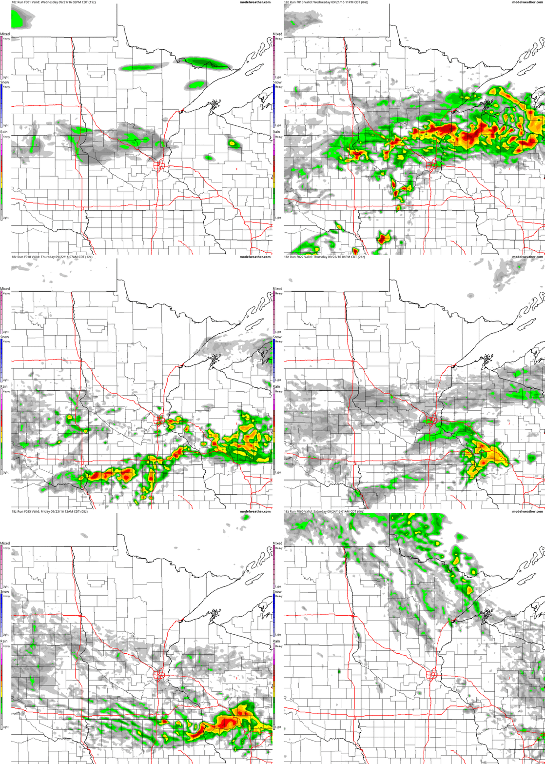
Heavy showers and T-storms linger along a stalled frontal boundary into Friday. A Flash Flood Watch remains in effect; the best chance of gully-gushing, window-rattling storms over southern Minnesota.
The mercury may hit 80F Saturday with some sunshine before more storms flare up Saturday night. Don't despair; skies clear on Sunday. Systems stall next week, a giant "cut-off" low pulling more rain into town by Tuesday.
Yeah, this is getting old.

- A slowly meandering/nearly stationary front across parts of the upper Midwest, combined with near record atmospheric moisture, will provide the set up for excessive rain across the region through Thursday.
- At least 2-5” of rain will fall across portions of Iowa, Minnesota and Wisconsin, with isolated higher amounts possible.
- This will lead to the potential of flash flooding in the region as well as rising lake and river levels. Flash Flood Watches are in place, including cities such as Sioux City and Waterloo (IA), the Twin Cities, Rochester and Mankato (MN), and Madison, Green Bay and La Crosse (WI).


Graphic credit: WeatherBell.


Summary. The first round of heavy rain last night brought 1-4” of rain across parts of southern Minnesota and Wisconsin. More rounds of heavy rain are expected across the upper Midwest over the next couple days, with rainfall totals of at least 2-5”. Some areas of Iowa, Minnesota and Wisconsin where there are slow moving storms or training storms could pick up 7”+ of rain through Friday morning. Due to the excessive rain amounts, flash flooding can be expected across these areas, and Flash Flood Watches are in place. Facilities across these areas that normally experience problems during flash flood scenarios should be on alert for issues over the next few days.
D.J. Kayser, Meteorologist, AerisWeather

Photo credit: "Cambodian land rights activists shout slogans during a protest in front of the Phnom Penh municipal court on Aug. 22 to demand the release of two prominent activists who were sentenced to six days in jail." (Tang Chhin Sothy/AFP).
S.E.C. is Latest To Look Into Exxon Mobil's Workings. The New York Times reports: "The Securities and Exchange Commission has requested information from Exxon Mobil on the company’s longstanding policy of not writing down the value of oil
reserves, as other energy companies have done in the recent past, Exxon
Mobil confirmed on Tuesday. The inquiry mirrors an investigation by the
New York attorney general, Eric T. Schneiderman, into how the company has valued its assets in light of future climate change regulations that may force fossil fuel companies to keep oil, natural gas and coal in the ground..."
How To Raise Trillions for Green Investments. Former Treasury Secretary Henry Paulson has an Op-Ed at The New York Times: "...The
good news is that there is a global abundance of private capital. To
unlock these riches, governments must create conditions that encourage
private investment in clean technologies and sustainable development.
With smart, well-designed and coordinated policies, financing models and
instruments like bonds and incentive programs, countries have the
potential to solve some of the planet’s most pressing environmental
challenges while still maintaining economic growth. That is why it is
essential for world leaders meeting in New York this week for Climate Week to stay focused on building an international consensus around “green finance...” (Illustration credit: Mikel Jaso).
How Tesla and Apple Could Be Good For Each Other. Here's an excerpt from The New York Times: "...For
Apple, with more than $230 billion of idle cash, the investment would
be close to a rounding error. Its shareholders would probably rejoice at
converting a sliver of money in the bank for a placeholder in an
emerging leader in self-driving cars. Unlike a full purchase, buying a
minority stake will not dilute Apple’s profitability, either. The
company has projected gross margins of around 38 percent in its next
fiscal quarter. Now, what could Tesla do for Apple? With a market
capitalization north of $600 billion, Mr. Cook’s business is doing fine
at the moment. Shares of the company have gained some 5 percent since
the iPhone 7 was unveiled earlier this month..."
1. Utah
2. Minnesota
3. North Dakota
4. Hawaii
5. Colorado
10 Bars At The End Of The World. I'd love to research every one of the drinking establishments highlighted at Atlas Obscura: "People
have found ways to live in the most inhospitable places on Earth.
Nearly immediately after finding a way to survive, they have found a way
to get drunk. Likely because of, rather than in spite of, the
challenges of living in the far reaches of the world, establishing a
communal space is a survival necessity. Be it at the base of an active
volcano, inside a 6,000-year-old tree, or even on your way to Mount
Everest, no matter how far off the grid you end up, you are likely to
find a place for strong spirits and lively conversation. Now raise a
glass to 10 of the oldest, most remote, and simply unlikely places in the Atlas at which to have a drink. Cheers!..."
Photo credit: "Vernadsky Station on Galindez Island, Antarctica." (Photo: Christopher/CC BY 2.0)
TODAY: Flash Flood Watch. Heavy showers and T-storms in the area. Winds: NE 7-12. High: 69
THURSDAY NIGHT: Still unsettled, another T-shower. Low: 59
FRIDAY: More showers, possible thunder - cool, damp breeze. Winds: E 10-15. High: 67
SATURDAY: Warm sunshine, T-storms arrive late. Winds: SE 10-20. Wake-up: 61. High: near 80
SUNDAY: Partly sunny, a drying breeze. Winds: W 8-13. Wake-up: 60. High: 71
MONDAY: Sunny start, then clouds increase. Winds: NW 7-12. Wake-up: 56. High: 66
TUESDAY: Another surge of rain moves in. Winds: N 10-20. Wake-up: 53. High: 65
WEDNESDAY: A foul sky: periods of rain and drizzle. Winds: SE 10-20. Wake-up: 54. High: 66
* Photo credit above from Lake Ossy: Pete Schenck.
Climate Stories...
375 Top Scientists Warn of "Real, Serious, Immediate" Climate Threat. Here's an excerpt of a Guardian article from Dr. John Abraham at St. Thomas University: "Yesterday, 375 of the world’s top scientists, including 30 Nobel Prize winners, published an open letter regarding climate change. In the letter, the scientists report that the evidence is clear: humans are causing climate change. We are now observing climate change and its affect across the globe. The seas are rising, the oceans are warming, the lower atmosphere is warming, the land is warming, ice is melting, rainfall patterns are changing and the ocean is becoming more acidic. These facts are incontrovertible. No reputable scientist disputes them. It is the truth. Despite these facts, the letter reports that the US presidential campaign has seen claims that the earth isn’t warming, or it is only a natural warming, or that climate change is a hoax..." (Image: NASA).

Climate Disruption is Fueling Stronger Storms. Friend and colleague Jeff Masters is staring at the same weather maps I am; here's an excerpt of an interview with PRI, Public Radio International: “I don't recognize the climate anymore,” says Jeff Masters, the director of meteorology for Weather Underground. “I look at the weather maps in the morning, sometimes afraid of what I'm going to see. It's just gotten so insane. The climate of the 20th century is gone. The climate I knew is not here anymore. We're in an entirely new climate regime, and it is extremely intense.” Climate scientists have been reluctant to attribute any one storm to the effects of climate disruption, but this may soon start to change. After historic rains fell on parts of Louisiana — an estimated 7.1 trillion gallons, three times as much as Hurricane Katrina — NOAA published a report which said that climate change made the storm at least 40 percent more likely today than a hundred years ago..."

No comments:
Post a Comment