Heavy Rain To Begin October
(map: AerisWeather)
If
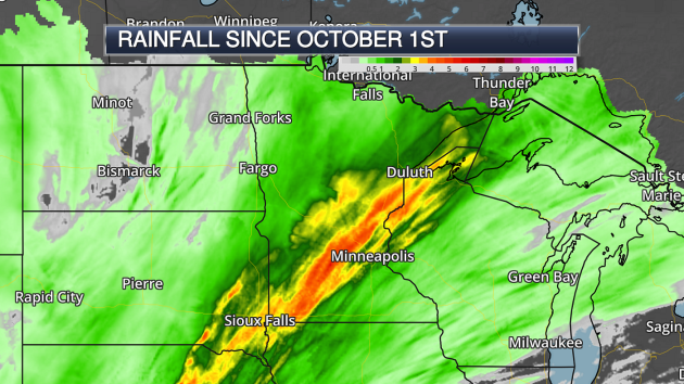
there was one word to describe the first few days of this month, "wet"
would certainly be that word. Particularly between Monday and Tuesday a
stripe of 3"+ of rain fell from Sioux Falls to the north shore of Lake
Superior. In some areas, the amount of rain that fell in a two to three
day span exceeded the amount that they would receive for the entire
month!
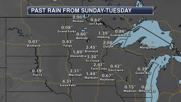
Here
is what fell across the state over the first three days of the month.
St. Cloud has picked up over 3" of rain, with areas like the Twin
Cities, Marshall and Duluth picking up more than 2". The Minnesota State
Climatology Office
has put together a list of rainfall totals across the state. The official rain total through the first four days of the month at MSP is 2.59".
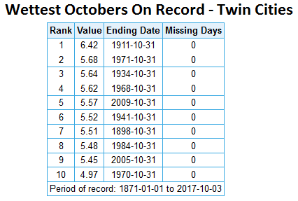
And for those keeping track, we only need approximately 4" of rain the rest of the month to see the wettest October on record.
_______________________________________________
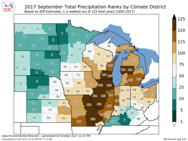
Wet September Across Central, Northern Minnesota
2017
ended up being one of the wettest Septembers on record across portions
of northwest Minnesota. According to the data crunched by the
Iowa Environmental Mesonet,
Climate Region 1 (which covers northwest Minnesota) saw their seventh
wettest September on record. The Midwest Regional Climate Center
estimates that an average of 5.43" of rain fell over that region, 231%
of average. The climate regions that cover central and northern
Minnesota all ranked in the top 50 wettest Septembers on record
according to the IEM, with the southeast region ranking in the top 50
driest. Overall, according to the preliminary data from the Midwest
Regional Climate, Minnesota on average saw 4.02" of rain last month,
which would rank as the 22nd wettest September. The official numbers
will come out from NCDC later this month.
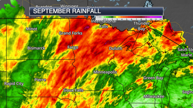
(map: AerisWeather)
Over
6" of rain fell across parts of the state in September, including in
Hibbing and Brainerd. Parts of southern Minnesota ended up with less
rain, including only 1.04" at the Twin Cities airport and 2.17" in
Rochester.
_______________________________________________
More Rain Brewing - Growing Risk of Hurricane Nate
By Paul Douglas
The
first Twin Cities frost may be 12-15 days away. Keep in mind the sun
will be as high in the sky today as it was back on March 8. Nights are
getting longer - Canada is catching a cold - sneezing a series of
increasingly numbing fronts.
Last year our first 32-degree
temperature of the winter season didn't arrive until November 18; a
220-day growing season for the Twin Cities! With a La Nina cooling phase
in the Pacific I suspect earlier frost and flurries this fall. Just a
gut feeling. Could be nausea.
In the meantime clouds increase
today; the best chance of showery rains south of MSP. Heavier, steadier
rain arrives Friday PM into Saturday as another storm tracks from Des
Moines to Milwaukee. Up to an inch of additional rain may fall
by Saturday night. Great news for mud-lovers everywhere.
We
salvage some sunshine Sunday; a chilly start early next week gives way
to 70s within a week or so. Soak up any lukewarm fronts.
Meanwhile,
there's a good chance "Nate" will become a minimal hurricane before
coming ashore Sunday, possibly over the Florida Panhandle. Make. It.
Stop.
_______________________________________________
Twin Cities Extended Forecast
THURSDAY: Few PM showers. High 61. Low 51. Chance of precipitation 50%. Wind SE 3-8 mph.
FRIDAY: Another round of late PM showers. High 62. Low 52. Chance of precipitation 60%. Wind NE 5-10 mph
SATURDAY: Steadier, heavier rain possible. High 60. Low 53. Chance of precipitation 80%. Wind W 8-13 mph.
SUNDAY: Partly sunny, nicer day of the weekend. High 64. Low 49. Chance of precipitation 10%. Wind W 7-12 mph.
MONDAY: More clouds than sun, cooler breeze. High 58. Low 47. Chance of precipitation 20%. Wind NW 10-15 mph.
TUESDAY: Mostly cloudy, light jacket weather. High 56. Low 38. Chance of precipitation 20%. Wind NW 8-13 mph.
WEDNESDAY: Bright sun, light winds. High 59. Low 45. Chance of precipitation 10%. Wind SW 5-10 mph.
_______________________________________________
This Day in Weather HistoryOctober 5th
1963: A heat wave hits part of Minnesota with highs of 98 at Beardsley, 96 at Madison, and 94 at Elbow Lake.
______________________________
_________________
Average Temperatures & Precipitation for MinneapolisOctober 5th
Average High: 63F (Record: 88F set in 2011)
Average Low: 44F (Record: 25F set in 1952)
Average Precipitation: 0.09" (Record: 2.31" set in 1911)
______________________________
__________________
Sunrise/Sunset Times for MinneapolisOctober 5th
Sunrise: 7:16 AM
Sunset: 6:45 PM
*Length Of Day: 11 hours, 29 minutes and 6 seconds*Daylight Lost Since Yesterday: ~3 minute and 5 seconds
*Next Sunrise At/After 7:30 AM: October 16th (7:30 AM)*Next Sunset At/Before 6:30 PM: October 14th (6:29 PM)
_______________________________________________
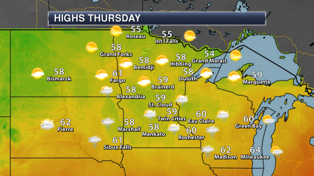
Minnesota Weather Outlook
Highs
will be stuck in the 50s across most of the state Thursday, with the
best potential of reaching 60 across southern areas. We will be watching
the potential of a few showers or thunderstorms across the southern
half of the state, but chances are only sitting at about 30% in the Twin
Cities. Northern Minnesota will see sunnier skies.
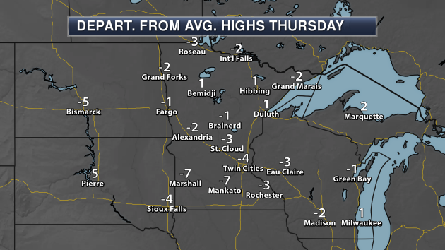
In
many areas, highs will be within a few degrees of average Thursday,
with the greatest departure from average values expected across parts of
south-central and southwest Minnesota.
We
will continue to remain within a few degrees of average through the
weekend, with highs mainly in the 60s in the Twin Cities. We do see a
push of cooler air work in toward the middle of next week, and we may
have to watch the potential of frost across parts of the state as we
head toward next Wednesday and Thursday morning. We could even see the
first 30s of the fall season in the Twin Cities.
Rain
will be possible across from southwest to northeast Minnesota once
again starting Thursday and lasting into Saturday. The best chance of
rain Thursday will be to our south, with the main precipitation shield
working across the state Friday into early Saturday. Areas across
southern Minnesota - including the Twin Cities - have the best chance of
seeing at least an inch of rain. Places in southeastern Minnesota could
see two or more inches.
_______________________________________________
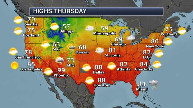
National Weather Outlook
A
warm front will be lifting north across parts of the Central Plains and
Midwest Thursday, which will help to bring rain - heavy at times - from
Kansas to Illinois. We'll be tracking the potential of showers and
storms as well across parts of Florida and southern Texas with ample
moisture in place. Those in the eastern U.S. will enjoy a warm day, as
highs are expected to reach the 80s as far north as New York City.
Chilly weather can be expected across the Northern Rockies into the
upper Midwest.
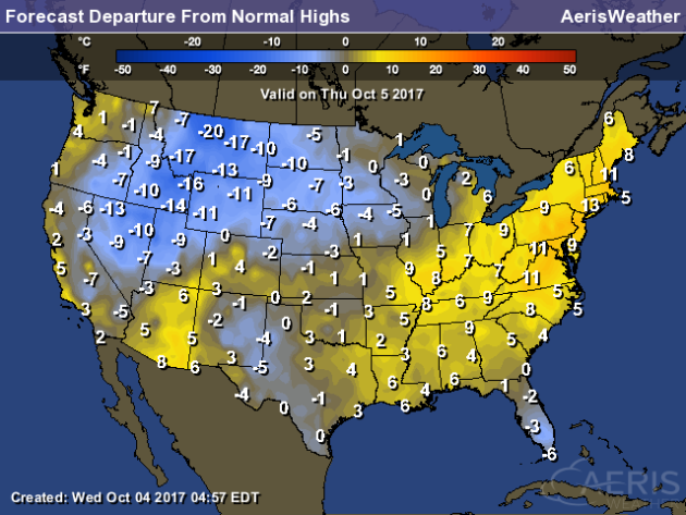
Much
cooler than average weather is expected once again Thursday across
parts of the Northern Rockies, with highs that will be a good 10-20
degrees below average for this time of year. Warmer than average weather
will be found from the northern Gulf Coast into New England, with highs
that will be 5-15 degrees above average.
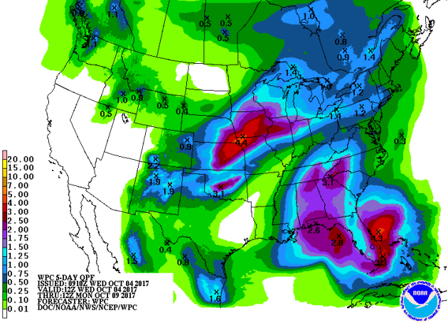
Over
4" of rain can be expected through Monday morning across portions of
the Central Plains, with most of that falling through the end of the
week. We'll watch the potential of flash flooding along with that heavy
rain. Meanwhile, ample tropical moisture could bring parts of Florida
2-4" of rain through early next week. We'll also be watching the
northern Gulf Coast, as heavy rain will be expected along the path of
what will become Nate.
(map: AerisWeather)
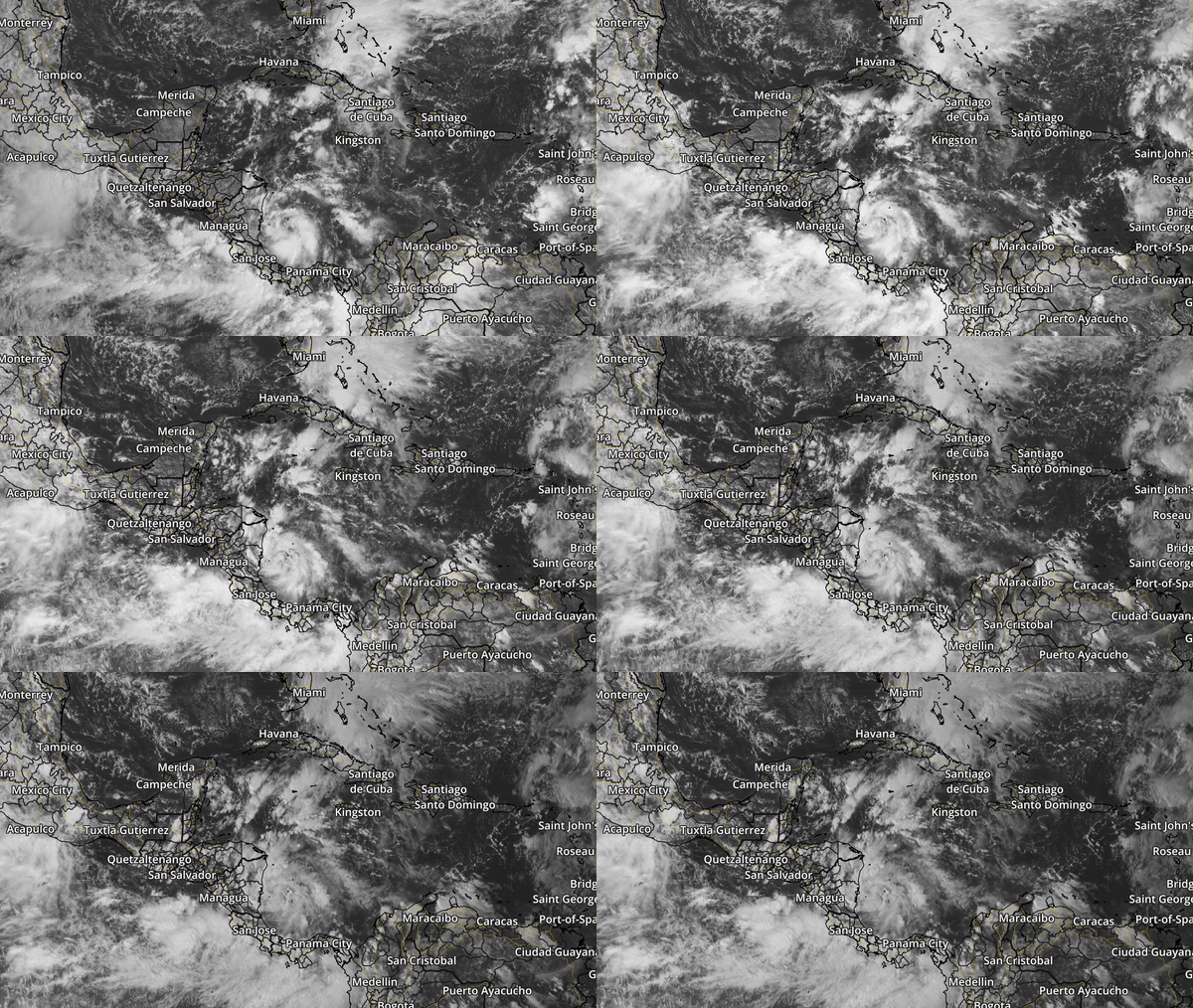
Speaking
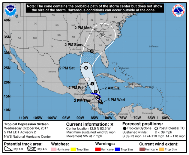
about what is expected to become Nate, Tropical Depression 16 formed in
the southwest Caribbean Sea during the day Wednesday, and according to
Air Force Reserve Hurricane Hunters has a well-defined circulation. The
system is expected to strengthen into a tropical storm soon.
Tropical
Depression 16 (future Nate) will continue to move to the north and
northwest over the next few days. The storm will pass over Nicaragua and
Honduras in the next day or so, then pass near the Yucatan Peninsula
Friday. The system will continue moving into the Gulf of Mexico as we
head into the weekend, and it is expected to strengthen into a hurricane
by the time it makes landfall somewhere along the northern Gulf Coast
Sunday.
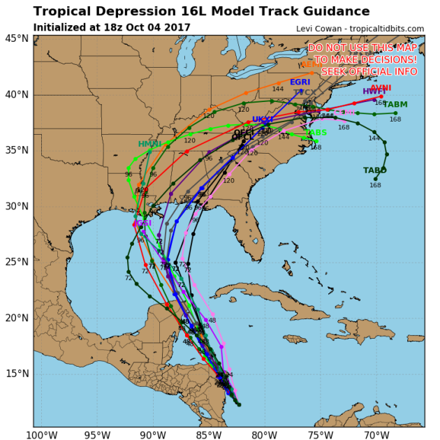
We
say somewhere along the northern Gulf Coast as there is still
disagreement over where landfall may occur. Recent model runs have
brought the system a little further west, but there is still
considerable spread - with models showing the potential for landfall
anywhere between Louisiana and the Florida panhandle. We will know more
over the next few days, as extra weather balloon launches and hurricane
hunter flights will gather more atmospheric information and help to make
better forecasts.
_______________________________________________
Extreme Drought Impacts Honey Production In Montana
While
other problems have impacted bees across the nation, drought has
greatly impacted the honey harvest this year in parts of Montana.
More from the Billings Gazette: "
Their
honey yields are down 50 percent from last year, and climate change
could mean more of the same. Extreme drought and record-setting wildfire
smoke are both factors Wüstner pointed to as culprits. “This is the
roughest year we’ve seen in two generations of beekeeping,” Wüstner
said. “Of course we have to leave enough honey for the bees to survive
the winter, so it’s kind of throwing a wrench in our business model.”"
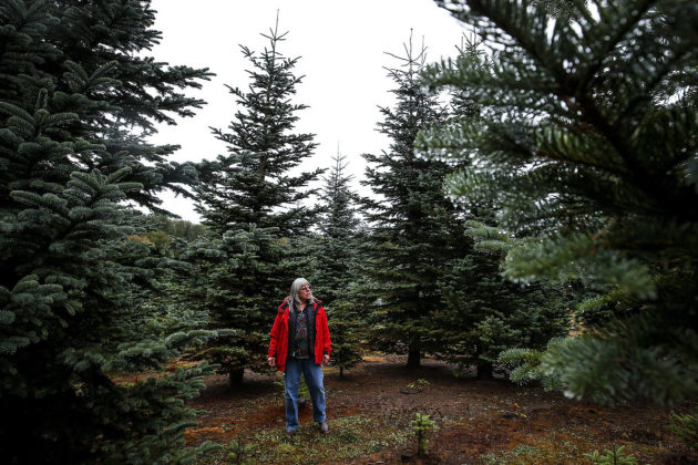
Drought Affecting Christmas Trees
It
may be October... but I already see Christmas decorations in stores.
Christmas tree growers in the Northwest, however, have been dealing with
stressed trees and seedlings dying due to the record dry weather this
summer.
More from the Herald of Everett, WA: "
This
winter and spring saw record-breaking rainfall in the region, but the
summer countered with record-breaking heat and dryness. Though rains are
returning, the Seattle area recently witnessed its longest known
stretch without, and temperatures soared during heat waves in July and
August. That takes a toll on Christmas trees, even in The Evergreen
State. The effect varies from farm to farm. Some are holding up just
fine, with trees rooted in the area’s thicker, wetter soils. Others are
struggling as needles fall from heat-stressed trees and seedlings
swelter." (Image: Lanai Hemstrom walks through rows of trees at her
Hemstrom Valley Tree Farm in Granite Falls on Tuesday. Hemstrom’s trees
have been affected by the record dry weather over the summer and have
shed more needles than usual. (Ian Terry / The Herald))
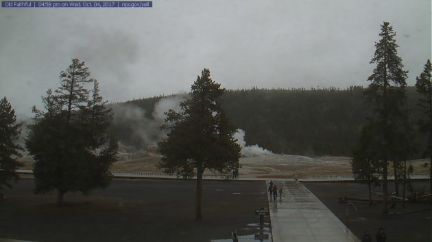
Yellowstone Earthquakes
Since June, Yellowstone has been experiencing an earthquake swarm. The good news is that it appears it’s staring to calm down.
More from Gizmodo: “
Do
not lose sleep tonight, the world will not end as the result of some
enormous supervolcano eruption in Yellowstone National Park any time
soon. But there is a whole lot of other interesting stuff going on
there—so maybe it’s worth losing sleep by getting excited about science.
Nerd. A swarm of earthquakes rumbling since June has begun to die
down, according to an update from the Yellowstone Volcano Observatory.
Newsweek reports that this has been the longest swarm on record, with
almost 2,500 earthquakes hitting the park since June 12. But despite the
recent though seemingly eternal hype surrounding the supervolcano and
its supposed apocalypse-causing potential, this is just business as
usual.”
_______________________________________________


No comments:
Post a Comment