 Weather Perfection. THAT'S what I'm talking about! I took this shot yesterday, a tired Saturday sun illuminating jet contrails which had spread out into high, thin cirrus clouds about 25,000 to 30,000 feet above the ground. It turns out we are having a subtle impact on weather every day. Jet contrails over busy airport corridors can keep afternoon temperatures 1-3 degrees cooler during the day, and a couple degrees warmer at night than they would be otherwise.
Saturday's high in St. Cloud: 74 degrees.
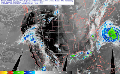
 Enhanced IR Satellite. Hurricane Bill sweeps north, brushing Cape Cod and coastal New England with gale force winds and 10-15 foot seas. High pressure centered over eastern Iowa will turn Minnesota's winds around more to the south/southwest today, temperatures should be 5-6 degrees warmer than yesterday with a little more humidity in the air, but all in all another amazingly fine late August day!
Pure unmitigated weather bliss. Translation: really, really nice. I'm still dazed and amazed, smiling uncontrollably, hyperventilating after what may have been the most amazing Saturday of summer. Check that, yesterday may have been the best day of summer: virtually no wind, crisp humidity levels, unlimited visibility, lukewarm temperatures, even the mosquitoes seemed to back off out of respect for a postcard-perfect day - the result of a ridge of high pressure overhead: a dome of drying, sinking, slowly warming air directly above our (grateful) heads.
 WRF/NMM (NAM) Model Prediction for 1 pm temperatures today. Note readings at or above 80 over roughly the western half of Minnesota. The farther west you go, the stronger the (southerly) breeze and the better the odds of cracking the 80 degree mark.
We're waking up to some 40s Sunday morning, a touch of fog in a few river valleys, an omen of what's to come in the weeks ahead. Temperatures will warm rapidly today as winds pick up from the south, reaching the 10-15 mph. range this afternoon as the mercury flirts with the 80 degree mark. Today's warming trend spills over into Monday with highs in the low to mid 80s, a dew point reaching the low 60s, meaning more noticeable levels of humidity in the air (expect a few complaints). An eastbound cool front sparks a spirited round of showers and T-storms Tuesday, followed by drier, sunnier weather by midweek.

 The Great Minnesota Get Together. It's baaaack, the Minnesota State Fair, kicks off Thursday of this week (how did THAT happen?) If you hope to get out sooner rather than later you may just be in luck, weatherwise. Computer guidance is hinting at near-perfect weather for Thursday's grand opening: plenty of sun, highs from 80-82 with a comfortable dew point in the mid to upper 50s...probably dry. No stinking hot weather is in sight, in fact it may cool down noticeably early next week, highs in the 70s, even some 60s by Monday or Tuesday of next week. It's early, but Saturday appears to be the nicer, drier, warmer day of the weekend for the fair, or one more mad dash up to the cabin. The chance of showers/T-storms will increase during the day Sunday, one week from today.
Today's Outlook for the greater St. Cloud area
Today: Mostly sunny, breezy and warm - a fine summer day. Winds: South 10-15. High: 80
Tonight: Clear to party cloudy. Low: 58
Monday: Hazy sun, warmer - still dry. High: 83
Tuesday: Unsettled with a good chance of showers, few T-storms. High: 79
Wednesday: Sunshine most of the day, very pleasant. High: 81
Thursday: Mostly sunny, not too many complaints. High: 82
Friday: Partly cloudy, seasonably mild. High: 79
Saturday: Probably the sunnier, drier, nicer day of the weekend - fading sunshine. High: 78
Sunday: More clouds, showers and T-storms arrive. High: 74
No comments:
Post a Comment