Whoop - There It Is
Top ten warmest Novembers on record in the St. Cloud area looks like a shoe in this year. Top 5... Yep! The warmest... Not quite. We are currently sitting in the 2nd warmest Novembers on record slot and we're gonna be close to finishing there. The average temperature at the St. Cloud airport is: 39.8 degrees, 10.4 degrees above average. The current 2nd warmest is 39.5 degrees in 1899 and the warmest is 41.8 in 2001.
Most Snow in a Long Time:
Doppler out of the Twin Cities early Sunday morning showed a band of snow moving through central Minnesota - the most we've seen on the radar in quite some time. Snow totals from Sunday's event are listed below.

 INCHES  LOCATION                 ST  COUNTY           TIME
------  -----------------------  --  --------------   -------
2.00   2 N CAMERON              WI  BARRON           0738 AM
2.00   6 NW RICE LAKE           WI  BARRON           0738 AM
1.50   CLAYTON                  WI  POLK             0415 AM
1.30   2 SE CHETEK              WI  BARRON           0900 AM
1.20   2 SE CHISAGO CITY        MN  CHISAGO          0900 AM
1.20   5 NE FOREST LAKE         MN  CHISAGO          0738 AM
1.00   3 W LADYSMITH            WI  RUSK             0900 AM
1.00   1 SW BOYCEVILLE          WI  DUNN             0832 AM
0.90   JIM FALLS                WI  CHIPPEWA         0738 AM
0.60   STANLEY                  WI  CHIPPEWA         0900 AM
0.60   HAMMOND                  WI  ST. CROIX        0900 AM
0.50   3 SE LAKE ELMO           MN  WASHINGTON       0758 AM
0.20   1 W WOODLAND             MN  HENNEPIN         0900 AM
0.20   ROBERTS                  WI  ST. CROIX        0900 AM
0.20   FARMINGTON               MN  DAKOTA           0900 AM
0.20   LONG PRAIRIE             MN  TODD             0900 AM
I felt a little foolish putting up holiday decorations this weekend. Second guessing myself, thinking maybe it's a little too early, too warm? Though, by looking around my neighborhood, I'm a little late keeping up with the Jones'. I had to turn on the XM radio, find the Christmas music, to help get in the holiday cheer. It's tough to get in the spirit when it doesn't look or feel like the holiday season. Temperatures will begin to wreak of early December by the end of the week. High temperatures will have a tough time getting into the 30's by Thursday with many locations staying in the upper 20's. The adjustment period begins as the coldest air of the season oozes out of Canada. Looking ahead, it may even be colder the 2nd week of December as a large low over Hudson Bay rotates cool air in from the Polar regions. Interestingly, the same storm that is bringing rain to southern California (ending San Diego's 4th longest stretch of dry weather 164 days! The longest was 182 days in 2004) will be the same storm that funnels the cold air into the northern tier states. Look here - watch the disturbance move from the southwestern part of the country to the Hudson Bay over the next 180 hours. It appears that the Low over the Hudson Bay will absorb the California Low by this weekend - interesting huh?
Next Chance of Snow
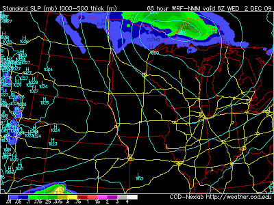
For the month of November so far, the St. Cloud Airport is 1.16" behind normal precipitation with only a trace of snow being reported, that is 8.8" behind normal snowfall for the month. Our next best chance of any moisture looks to remain along the international border and Arrowhead region - see animation here:
The image below shows the next clipper skipping across the international border Tuesday night/early Wednesday morning:

Todd's Outlook for greater St. Cloud
Today: Partly sunny, perhaps a flurry or two and a bit milder. High: near 40
Tonight: Mostly cloudy. Quiet. Low: 30
Tuesday: Mildest day of the week, fading sun, still unseasonably mild. High: 43
Wednesday: Gusty and colder with a few flurries in the air. High: near 30
Thursday: Unsettled, lot's of clouds, a few flakes around. High: 27
Friday: More sun, not as cold. High: 30
Saturday: Partly cloudy. High: near 30
No comments:
Post a Comment