* A few PM showers, possible thunder for the Edina Art Fair and Grand Old Days in St. Paul. Take something waterproof for the PM hours (but it probably won't rain as long or as hard as it did yesterday).
O.K. You got out of mowing the lawn, right? Trying to put a positive spin on today, but it's the meteorological equivalent of trying to sugar-coat a turd. My apologies if you had (outdoor) plans for the morning hours. What happened? Why are Minnesota meteorologists (myself included) dining on a fine crow-souffle? A frontal boundary stalled out over southern Minnesota, a wave of low pressure rippled east along this boundary, throwing up a (rare) shield of heavier, steadier rain across central and southern Minnesota - the kind of feature you'd expect to see in early April or mid October, but June? This time of year the only thing that can generate an all-day washout is a stalled front, and frankly, we were all caught with our Dopplers down. No excuses; such a "busted" forecast is almost acceptable on a Tuesday or Thursday, but on a Saturday? Inexcusable. I should be bull-whipped, tarred and feathered, forced to watch reruns of "Wake up with Al (Roker)" for hours on end, my Doppler privileges rescinded until further notice.
 24 Hour Rainfall. Check out the amounts over southern MN, where the steadiest, heaviest rains fell on Saturday, anywhere from .20 to .40". The farther north you went, away from the frontal boundary, the lesser the rainfall amounts - a tenth of an inch of rain in St. Cloud, just .02" in the Brainerd Lakes area, NO rain for Bagley and Bemidji.
It's a humbling profession - just about the time you think you have Minnesota Weather figured out, Mother Nature delivers a firm, swift kick. I get it - 12 (precious) weekends during a fleeting Minnesota summer - every one is a gift. People take it personally when it rains (hard) on a weekend, especially when the rain was underestimated and plans were made. We had showers in the forecast for the afternoon hours, but I was mildly horrified (and humbled) by the sheer extent and duration of the rain. Ugh....
I schlepped around the Edina Art Fair much of Saturday, rubbing elbows (and soggy umbrellas) with hundreds (thousands?) of brave souls who weren't about to let a little rain ruin the fun. I was impressed with the turn-out, in spite of the weather conditions, which were pretty foul, a cold, hard, steady rain. "Better than last year," one artist mused, motioning up at a threatening sky. An optimist. Other running commentary: "Paul, fix it.....Paul, make it stop! Paul, I moved to Naples, Florida to get away from this, and to get away from YOU!" I think he was kidding, but I'm not absolutely sure. Tough crowd.
Hey, better than hail, tornadoes, snow (it has been known to snow up north in early June) and random oil spills, at least it was in the 60s, in spite of the long, cool soaking it didn't feel that bad out there. We've just been spoiled: second warmest spring on record, a string of unusually sunny, mild days (and weekends). We've been pampered for the better part of March, April, May and early June. O.K. It rained on a Saturday - we should just deal with it, get caught up on errands and indoor activities (picking up a book or a newspaper?) and just grin and bear it, 'cause we all know that the odds of a similar washout (today) are slim to 'nil.
 Another Round. Although I don't expect the steady, soaking we endured Saturday, a wrinkle of unusually cold air aloft will ignite another spirited round of showers, even a few T-storms by afternoon and evening. Have a Plan B after lunch - the NAM weather model prints out .10" of rain later today. Another complimentary lawn and flower watering.
Today won't win any awards for beauty and splendor, but it should be an improvement. Pretty much ANYTHING would be an improvement over yesterday's gully-gushing, windshield-splattering soaking. .20 to .30" of rain fell in the Twin Cities, .40" from Austin and Windom to Madison. Amounts dropped off farther north and west, with .1" of rain at St. Cloud, .02" at Brainerd and NO RAIN in Bagley and Bemidji. Highs barely reached 70 in the metro area, about 10 degrees cooler than normal, thanks to thick clouds and steady rain, which can keep readings 10-20 degrees cooler than they would be on an otherwise sunny, dry day. At least the sun came out by late afternoon - treating us all to a beautiful evening, and a well-deserved sunset. The day wasn't a total loss, but close.
Turn the page. Time to look ahead, see if we can salvage part of our weekend. There should be some sun during the morning/midday hours, the atmosphere still relatively stable. But a steep "lapse rate" (temperatures falling faster with altitude than typical) should leave the sky unstable by afternoon, capable of another swarm of showers and T-storms - not a steady soaker like we muddled through yesterday - I pray.
We get a brief break on Monday (more sun, highs in the low/mid 70s) before the next round of showers arrives Monday night and Tuesday, maybe another .10 to .20" of rain. A weak bubble of high pressure clears us out (temporarily) Wednesday and part of Thursday before a surge of hot, sticky air arrives - this next warm front sparks a few random T-storms from late Thursday into Saturday, in fact a few storms may be strong to severe, especially Friday and Saturday. It's too early to try to get specific - just know that by the end of this week it will definitely feel like summer again, highs well up in the 80s, dew points in the 60s - neighbors whining about beastly humidity levels. There are some signs it may cool off and dry out a bit for Sunday as the front shifts east, but that's pure speculation at this point. Enjoy the break from heat and humidity, and get out (early) or risk being chased indoors by a fickle, more summerlike shower or T-storm by mid afternoon. Ah, spring in Minnesota. Blink. Sneeze. Hiccup. Look away for an instant and the sky overhead will change. Count on it.
 Storm Chasing (auf Deutsche). Go along on a storm chasing adventure in Holt, Missouri with a meteorology enthusiast (who speaks fluent German!) If your Deutsche is a little rusty, no worries - the video speaks for itself.
 Oregon Flooding. The storm track has been stuck in a rut, blowing soggy Pacific storms into Oregon and California, a pattern more typical of late March than early June. The result: serious flooding on the Willamette River, near Springfield, Oregon. Video courtesy of "WheeliePete" and our dear friends at YouTube.
 "Phet" Update. Once-mighty Cyclone Phet is now a tropical disturbance, drenching coastal Pakistan after inundating the country of Oman, where the deserts were transformed into lakes from 10-20" rains. The latest update from the BBC is here.
 "Phet's Track. Once the second-strong cyclone (same thing as hurricane) in the Arabian Sea, Phet weakened rapidly after slamming into coastal Oman. The track of the storm courtesy of the University of Wisconsin (which has an amazing meteorology department, btw). Click on the yellow hurricane icon and wonderful things will happen to your PC.
 Forecasting Tornadoes. America experiences more tornadoes than any other nation on earth (over 1,000/year, on average). The science of tornado prediction has improved in recent years, the average "lead time", the number of minutes between when a tornado is detected, warnings issued, and when the tornado actually hits - has doubled from 6 to nearly 15 minutes since the mid 70s). But mysteries remain: why do some tornadoes strengthen into monsters, while others quickly fizzle? Sometimes the most intensely rotating thunderstorms DO NOT spin up tornadoes, so rotation alone isn't the key to tornado prediction - the surrounding environment is critically important. An interesting update on tornado forecasting from NOAA is here.
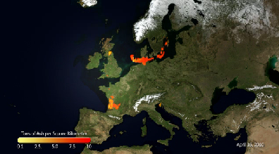 Volcanic Ash Makes For Unfriendly Skies. Great, just what you want to see before getting on a flight to Europe. Who knew there was a global network of "Ash Advisory Centers", all monitoring current and predicted volcanic eruptions and the possible impact on aviation, agriculture and life in general. Another fascinating article from NOAA is here.
 Expanding Disaster. Here is the Monday forecast for where the core of the oil should be located in the Gulf of Mexico. EPA's web site focusing on the oil spill is here.
 No Fishing. An estimated THIRD of the Gulf of Mexico is closed to fishing, because of the expanding smear of light, sweet (?) crude getting swept up in the clockwise-rotating "Loop Current". The latest advisory map is here. The federal government's official site, "Deepwater Horizon Response" is here.
 Tracking the trends. This graph is a bit tough to read, but if you click on it and bring it full-screen you can see how the oil stain has expanded over time, now closing nearly a third of the Gulf to fishing. As of June 4 32.3% of the Gulf was closed to fishing, that's down from 36.6% of June 2. Click here to see the very latest.
 Live Stream. Ustream and PBS have a live feed of the underwater spill here. Oil balls are washing up on Pensacola Beach, Florida - the story is here. Imagine spending hundreds or thousands of dollars on a Florida vacation, only to wander out onto an oily beach. Imagine trying to make a living from fishing, tourism - anything, and being at the mercy of a force that can't be accurately quantified or predicted. At least a hurricane has a beginning and end - you can see it coming and take precautions. But oil? I can't even imagine what it must be like living on the Gulf right now, overwhelmed by a sense of dread, not knowing what the next day's tide will bring in.
 Oil Spill Facebook Page. Yes, everyone and everything has its own FB page these days. Click here to stay up to date without ever leaving the cozy confines of Facebook.
 Oily Tweets. Not to be outdone by FB, Twitter is a very good way to get updates, photos and videos related to the oily mess in the Gulf of Mexico - click here to "follow" Oil Spill 2010; a few nuggets here you won't see on CNN or Fox News.
 Recession Wheels. Yeah, even Batman has to downsize during the current downturn. Bummer.
Paul's SC Times Outlook for St. Cloud and all of central Minnesota
Today: Partly sunny, better than yesterday. Showers likely by afternoon, even a passing T-storm. Winds: NW 15-25. High: near 70
Sunday night: Evening showers, then slow clearing late. Low: 52
Monday: More sun, probably dry. High: 71
Tuesday: Unsettled, another round of showers, possible thunder. High: near 70
Wednesday: Plenty of sun, possibly the best day of the week? High: 76
Thursday: Less sun, more humidity - risk of a passing T-storm. High: 79
Friday: Windy and warm with hazy sun - a few strong T-storms possible. High: 83
Saturday: Sticky and warm with scattered T-storms, some strong to potentially severe. High: 81
No comments:
Post a Comment