 Tuesday Almanac. With bright sunshine the mercury soared to 84 in St. Cloud (where dew points held in the 50s), 88 in the Twin Cities, where dew points lingered in the low 60s, a bit stickier, but still tolerable. Rainfall amounts since 7 pm Monday were significant, ranging from .35" at Eden Prairie to .47" at MSP International. Some 2-3" amounts were reported in some towns from Monday evening's tropical downpours - a complete rundown from the high-resolution CoCoRaHS network of weather spotters is here.
 Monday Evening Soaking. These are Doppler radar estimates from Monday night's soaking rains. For the first time (ever) I watched a line of heavy thunderstorms move west, then stall, before pushing east again, passing over the same counties. The result: 2-3 week's worth of rain falling in less than 6-8 hours, more than 3" in a few towns.
Sorry for the rant - but I still believe (more than ever) that every home, apartment, school and office building should invest in a $30-40 NOAA Weather Radio. The new ones are impressive - "SAVE" technology means you can program in just your county - so the thing won't be going off night and day, just when your county is in the path of a severe, life-threatening storm. Your smart phone won't do that, neither will the 'net. I still maintain that NOAA Weather Radio is the cheapest, most effective form of life insurance you'll ever have in the house. Like any other form of insurance you don't need it until you REALLY need it.
We enjoyed our one-day ration of warm sunshine, now it's back to battening down the hatches, waiting for another spirited round of showers and T-storms to arrive. The latest NAM/WRF model prints out nearly .75" of rain later today and early tonight - the risk of severe weather is slim, but expect torrential downpours, along with frequent lightning, possibly spiked with pea or marble size hail. The risk of thunder increases as the day goes on - the best chance of being chased indoors comes between 3 pm and 8 pm.
 Stormy Bullseye. The NAM/WRF model prints out heavy T-storms right over the Twin Cities metro area around the dinner hour today, probably not severe, but capable of pea-size hail, downpours and frequent lightning. As much as .50 to 1" of rain may fall during the late afternoon and evening hours.
Winds swing around to the northwest Thursday, drying us out - plenty of sun expected Thursday, Friday and much of Saturday as a weak bubble of high pressure drifts overhead. This may be a "dirty high" (no snide comments please, this is a real meteorological term) - meaning we can't entirely rule out a few instability showers popping late Thursday, again late Friday - but at any given time less than 5% of the state will be seeing rain (the best chance coming late each afternoon over central and northern MN).
Saturday still appears to be the better day of the weekend, hazy, sticky sun hanging on much of the day, highs reaching into the 80s, a fine day to stake out your favorite lake or pool. Sunday doesn't look quite as nice, the next frontal boundary setting up an atmospheric tug-of-war, sparking a few hours of showers and T-storms. Still no sizzling heat, nothing like what is gripping the northeast.
 Record Heat. 103 in New York City Tuesday, the first triple-digit high in 9 years for the Big Apple. Highs reached 102 in Washington D.C. and Philadelphia. To see more records click here to see the Ham Weather interactive climate data. A story summarizing the debilitating heatwave is here.
 Air Pollution Alert. Not only is it hot, the air over much of the northeast is stagnant, light winds at the surface coupled with an inversion aloft, trapping man-made pollutants near the ground. Minnesota has seen a steady supply of drier, cleaner air from Canada. The latest AQI (air quality index) is here, courtesy of the EPA.
On Tuesday the mercury soared to a record 103 in New York City (the first time the Big Apple has broken through the 100-degree mark since 2001). Philadelphia saw 102, so did Washington D.C. - there were reports of power outages, record consumption of electricity had utilities straining to meet demand. In some of these big cities the nighttime lows won't go below 80 DEGREES! This is where people get into trouble - it isn't so much the daytime heat, but the lack of any relief during the nighttime hours. The result: strain on the heart and respiratory system, a much greater risk of heat exhaustion and heat stroke, which can be fatal if not treated in time. In 1995 a "heat storm" swept into Chicago - daytime highs hit 106 (with a dew point close to 80). It felt like 120-125 in the shade, nighttime lows stayed about 83 for 3 straight nights - it was a slow-motion disaster, an epic catastrophe that claimed over 800 lives. Hopefully we won't see a repeat of Chicago's heat disaster, the worst of the heat is forecast to ease later this week out east, but it's a reminder that (historically) July is the hottest month of the year.
 Drought Eases. Most of Minnesota, certainly the agricultural counties, are in much better shape, in terms of soil moisture, than they were a few weeks ago, thanks to recent (heavy) rains. Moderate to severe drought lingers over the MN Arrowhead. To see the latest drought information click here.
Finally, Minnesota farmers are in a pretty good mood, and they have every right to be. The drought has eased, moisture has been more than adequate (in fact it's now TOO wet across portions of central and eastern Minnesota, where rainfall amounts from Monday's downpours were VERY significant. We haven't had any widespread hailstorms, capable of flattening crops in a blink of an eye. At this rate we may be looking at a record harvest. More details on the state of Minnesota's agriculture here, courtesy of the Minnesota Department of Agriculture.
 Frayed Nerves. Residents living along the Gulf coast are keeping a nervous eye on the latest tropical disturbance. According to NHC (National Hurricane Center) there is a 40% probability that this cluster of T-storms will strengthen into Tropical Storm Bonnie within the next 48 hours. The latest from NHC is here.
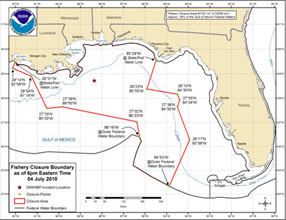 Fishing Closures. NOAA has released the latest data on Gulf waters closed to fishing, due to the spreading oil spill. 81,000 square miles are effected, roughly 33.5% of the Gulf of Mexico. The latest information is here.
 Oil Spill From Space. This is a high-resolution image taken from a low-orbiting satellite, showing the location of the spill and the oil, which clearly shows up from the satellite orbiting a little more than 200 miles above the Gulf of Mexico. Click here to see the image. Oil is now washing up on the Texas shoreline - the story is here. Good news: according to weather and ocean models used by NOAA, the risk of significant tar balls washing up on the Florida coast is small - the story here.
 Oil Fingers Reach into Louisiana's Inland Waters. For the first time oil from the Deepwater Horizon well has reached inland, all the way to Lake Ponchartrain. Click here to read the story.
 A Different Perspective. Look carefully - you can see the Space Shuttle blasting off just to the right of the guys strapped to those parachutes. Frankly, I'm amazed they even got that close to the Shuttle. A high-resolution version of this photo is here.
 WeatherNation - Studio A. O.K. I'm a little biased, only a little - but I have the pleasure of working with some of the best meteorologists in the nation. From left to right: Todd Nelson (St. Cloud State graduate, one of the first meteorologists to join the team, came from a TV station in Duluth, Kristin Clark, who we hired from Colorado Springs - her mom and dad are TV meteorologists in the Wilkes-Barre/Scranton market at the #1 ABC affiliate in America, her dad, Tom, was my college roommate and the best man at my wedding, Bay Scroggins, who has worked in Florida, and most recently, KSTP-TV, and Rob Koch, a true veteran in the industry, also a 'KS alum. Thanks for checking out the weather blog, and please tune in the weather videos, updated around the clock, to get a jump on the 7-Day AND the news behind the weather, a more comprehensive look at Minnesota's weather, on your schedule. To learn more about WeatherNation check out our home page and our sister company, Ham Weather, which has some amazing (free) graphics available on-line.
Climate Stories

Turning Up The Heat On Climate Change. No one heat wave proves or disproves climate change. This is "weather", not "climate." Just like a heavy winter snowfall doesn't disprove global warming, the current heatwave gripping the east isn't necessarily proof of climate change either. That said, if climate change is real (and 97% of the more than 1,000 active, peer-reviewed professional climate researchers recently polled believe it IS real) we can expect to see more frequent and severe heatwaves around the USA, along with more numerous and severe droughts nationwide. The story in Time is here.
Climate Change Could Be Worse Than Gulf Oil Spill. Hype? Possibly. But 2010 is on track to be the warmest year on record, again. 11 of the warmest years, worldwide, have occurred since 1997. Coincidence? Maybe, but with each passing day the odds of this being one great big cosmic joke get smaller and smaller. The story is here.
Climate Change Report Ignored "Positive" Effect of Global Warming. Hmm. A thought-provoking story in the U.K's Daily Express is here.

Scientists Study Global Warming's Impact on California Redwoods. California is warming, and foresters are increasingly concerned about the possible impact on the state's redwoods and giant sequoias. The story at KansasCity.com is here.
Paul's SC Times Outlook for St. Cloud and all of central Minnesota
Today: Humid, with a growing chance of T-storms, some heavy. Winds: SE 3-8. High: 81
Wednesday night: Lingering T-storms, some downpours likely. Low: 65
Thursday: Partly sunny, slight chance of a PM shower up north. High: 81
Friday: Plenty of sun, drier statewide as high pressure drifts overhead. High: near 80
Saturday: Probably the nicer day. Hazy sun, warm and sticky. High: 83
Sunday: Unsettled with more clouds, scattered showers and T-storms likely. High: 81
Monday: More clouds than sun, still warm. High: 83
Tuesday: More sun, warming up. High: 87
No comments:
Post a Comment