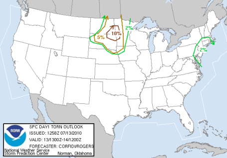
Tornado Threat. SPC has extended the "slight risk" of severe storms east, including the Twin Cities and most of Minnesota. There is a 10% probability of an EF2-5 tornado within 25 miles of any location in far northwestern/west central MN, mainly during the evening hours, when the atmosphere will be most unstable. The area of concern is from Moorhead, Detroit Lakes and Fergus Falls northward to near Thief River Falls and Crookston. Stay tuned for more updates throughout the afternoon - the greatest potential for tornadic "supercell" T-storms will come during the day Wednesday, when dew points are forecast to peak around 76 F in the metro area (extremely tropical air) with sufficient wind shear and instability to support a widespread severe storm outbreak).
No comments:
Post a Comment