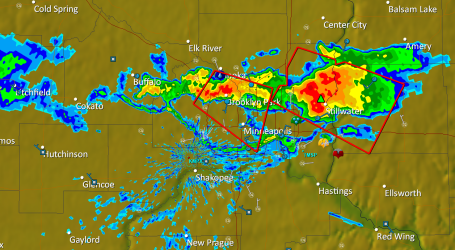
Update: 1:10 pm. Doppler shows a heavy T-storm in the Cambridge area, north metro, with severe storms northeast of Eau Claire, WI. Reports of damage to homes in Hammond, WI with street flooding reported at Rice Lake, WI. The sun is out just south of the Twin Cities - where heat indices are over 100. Fairmont is reporting a dew point of 81 with a heat index of 110! Very high moisture levels (dew points of 75-80) just south of the metro will fuel a line of severe storms between 1:30 and 4:00 pm, best chance of tornadic storms south of MSP, from New Ulm and Glencoe to Mankato, Northfield, Owatonna and Rochester area. We can't rule out a tornado in the metro area (especially southern suburbs) but I still believe the greater risk is farther south, but it may be a close call. Stay alert, stay tuned for more updates.
No comments:
Post a Comment