* Winter Storm Warning in effect, Blizzard Warnings south/west of MSP.
* Moderate to heavy snow continues into the evening hours, tapering to flurries tonight.
* Sharp cut-off to the heaviest snow bands - St. Cloud on the edge of the heaviest snow. I now expect closer to 3-6" for St. Cloud, little if any snow for Brainerd, maybe 1-2" Little Falls, but Willmar area will pick up 12-15" snow. Expect a huge north/south variation in final amounts across central Minnesota.
* Travel conditions on I-94 and 10 get worse as you approach the Twin Cities.
* Heaviest snow bands setting up over the southern/eastern suburbs of the Twin Cities: best chance of picking up 16" or more of snow - 30 mph winds will carve out some 2-5 foot drifts.
* Snow totals of 12-16" across much of the metro area by 9 pm tonight, closer to 4-8" for far northern suburbs.
* Close to blizzard criteria, especially outside the metro area. Sustained winds of 25-30 with gusts over 35 mph. will produce white-out conditions.
* Dangerous wind chills tonight and Sunday - dipping to -30 F. at times.

Heaps And Piles Of Snow. Here is the latest (NAM/WRF) model prediction for snowfall amounts - the heaviest amounts predicted for the southern suburbs of the Twin Cities - as much as 18-20" for the Rochester area. Amounts drop off sharply north/west of MSP, St. Cloud may wind up with 3-6" of snow - virtually nothing for Brainerd, maybe an inch for Alexandria. Just south Willmar could easily pick up over a foot of snow.
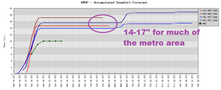
Latest Model Guidance. The computer models are converging on a solution of 14-17" for much of the Twi Cities metro, the best chance of over 15" south metro. The latest NAM model prints out .21" liquid for St. Cloud, which translates into 3-5", but again, you can expect dramatically more snow only 10-30 miles south of St. Cloud.
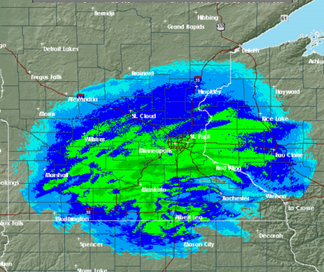
Stubborn Snow Bands. The heaviest bands are setting up over the south metro - amounts drop off sharply north/west of St. Cloud and Alexandria. My hunch is that some of the southern and eastern suburbs of St. Paul and Minneapolis will wind up with somewhere between a foot and 18" - with 2-5 foot drifts. The latest Doppler Radar is here.
* Latest snowfall reports are here, courtesy of the National Weather Service.
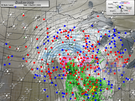
Snow Blitz of '10. Here is the latest surface map, the intensifying storm tracking across central Iowa into southern Wisconsin - a perfect track for heavy snow setting up over the Twin Cities.
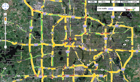
Getting Worse. Here is the latest Google traffic map for the metro area - I expect conditions to deteriorate as the day goes on (and winds increase).
No comments:
Post a Comment