35.3" So far this winter. Normal snowfall as of January 28 is 32.9."
21.6" Snowfall as of January 28, last winter.
13" Snow on the ground at MSP.
5 F. High temperature on January 28, 2010.
20 F. Normal high on January 28.
10.7" Snowfall so far this month in the Twin Cities (which is roughly 1" above average for January). Last year only .9" of snow had fallen in January, as of the 28th.
Weather Highlights: A cooling trend over the weekend (Saturday looks like the better day for outdoor fun, highs well up into the 20s). A clipper may brush the MSP metro area with a few inches (2-4") Sunday night into Monday. Commutes on Monday will be much slower than usual, a potential for compacted snow and ice as air temperatures drop through the teens into single digits by Monday night. Next week will be colder than average, at least 3-4 nights dipping below zero - but not quite as cold as last week. That said, it will probably be one of the 3 coldest weeks of the winter. Temperatures rebound late next week, a chance of another thaw by next Sunday, Feb. 5.
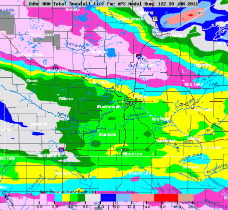
Potentially Plowable on Monday. Latest models are trending higher for snowfall amounts late Sunday night into Monday, about .34" liquid, which (at an air temperature in the teens) could translate into 2-4" of (light/powdery) snow for St. Cloud. Monday rush hour may be "memorable", a possible 4 on the dreaded Hassle Factor. It's still too early to be specific, but if the model trends continue I expect the NWS to issue an advisory, possibly a Winter Storm Watch for parts of southern and central Minnesota.
Sunday Night - Monday Clipper. I want to see 1 or 2 more computer model runs (to see if there's any continuity from run to run), but there is a growing chance of a potentially significant accumulation of powdery snow late Sunday into Monday, amounts piling up even more south/west of MSP by Sunday night, where some 8" amounts are possible. Models are hinting at 2-4" Sunday night into Monday for St. Cloud, more south, less north. With temperatures in the teens and single digits by Monday highways may be very slippery (MnDOT's chemicals work much slower when it's that cold). We'll see....stay tuned.
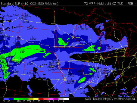 Monday Mess?
 We haven't seen a significant snowfall since January 13-14, when 4.4" fell over 2 days. In all probability Monday's snowfall will be at least 2-3", with an outside chance of 5 or 6" close to home. My strong hunch: Monday will be the slowest, iciest drive of the entire week. This (NAM) prediction shows accumulated snow from 1 pm to 7 pm Monday.
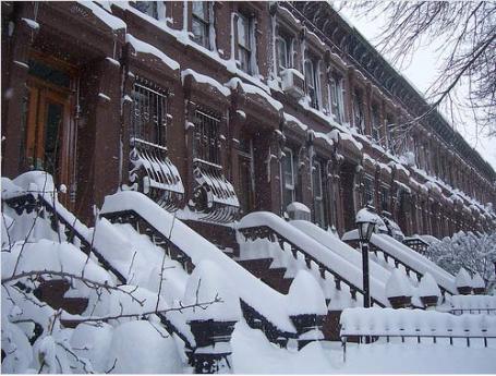
East Coast Storm Update. Many cities out east have run out of money for snow removal, no salt left to spread onto highways. Anywhere from 2 to 5 times more snow has fallen from Boston to Washington D.C. than normal, to date. People are looking at the 7-Day with a growing sense of dread. New York has seen their top 5 snowstorms on record in the last decade. Philadelphia has endured its top 4 snowstorms in just the last year! An update from Huffington Post is
here.
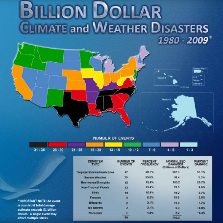
Relative Risk. Don't let anyone living in Atlanta, Dallas, New Orleans or Naples, Florida give you a hard time about our "challenging winters." At least the cold fronts won't (usually) kill you. NCDC has compiled a list of billion dollar disasters since 1980. The southern and southeastern USA has experienced roughly 3 times more billion dollar weather disasters in the last 30 years. The reason? Floods, tornadoes and hurricanes, the trifecta of severe weather risk. The lowest overall risk of weather disasters: Michigan to New England. Our weather is extreme, but at least we don't have to worry about Texas-size storms packing 100 mph+ winds on a routine basis.
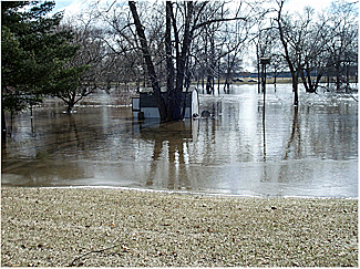
Spring Flood Potential. St. Cloud State University meteorologist D.J. Kayser has more thoughts on Thursday's NOAA press conference focused on the potential for major river flooding by March and April, specifically for central Minnesota and the greater St. Cloud area. Here is an excerpt from his detailed
blog post:
"
It looks more and more likely as each passing day comes by, and each puff of snow falls down, that spring flooding will be a MAJOR issue across much of the upper Midwest. Along the Red River in the Fargo and Grand Forks areas they could once again see near-record crest territory this spring. Here in southern MN, we won’t miss out either, with major flooding possible along the Mississippi, South Crow, and Minnesota Rivers (as well as others) as you can see in the chart above (more places and percentages can be found by going to the National Weather Service). We want to pay attention to the STC area though, and what might happen. First, the chances of flooding:"
For the Sauk River at St. Cloud…
- There is a 82% chance of minor flooding (a crest over 6′)
- There is a 32% chance of moderate flooding (a crest over 7′)
- There is a 4% chance of major flooding (a crest over 9′)
Our Brains Delete Information At An "Extraordinarly High Rate". This is especially true in my case. My senior memory continues to get worse with time. I envy people who can remember details, names of people (and their spouses) who they met years ago. How do they do this? To me this seems almost supernatural. A (reassuring)
story from geekosystem.com: "German researchers at the
Max Planck Institute for Dynamics and Self-Organization have discovered that
the brain deletes information at a rate of “one bit per active neuron per second,” which, to these German researchers, is an “extraordinarily high” rate. Basically, as we gain knowledge, the brain is just as quickly making room for it by getting rid of old data. Up until now, they just didn’t realize how fast this was happening, and the discover came as a “huge surprise.” That makes sense because their initial discovery could have very well been the information that was deleted, so they got to discover it all over again! Surprise!"
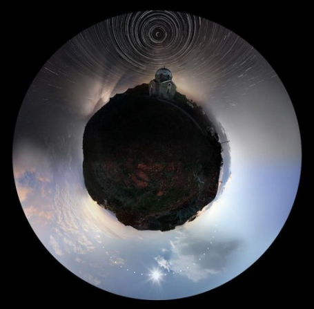
An Entire Day Photographed. I've never seen anything like
this - compliments of the geeks over at neatorama.com. How on Earth do you photograph an entire day - in one photo? "
It kind of looks like the planets in Antoine de Saint-Exupéry’s The Little Prince, doesn’t it? Photographer Chris Kotsiopoulos created this picture out of many photographs taken over the course of a day in Athens, Greece."
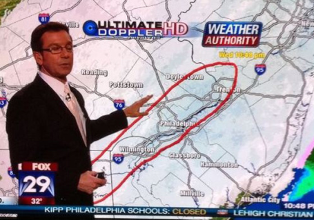
Best To Avoid The Philadelphia Area. Fox-29's Chief Meteorologist John Bolaris was predicting a major snowfall for his local market Wednesday night. Those are some pretty cool weather graphics, don't you think? What I'd give for Ultimate Doppler HD.

 Friday Stats
. The mercury reached 30 in the Twin Cities, Eden Prairie and Crystal, a balmy 32 at Redwood Falls and
27 in St Cloud. It was a few degrees cooler than predicted (thought we might see 32). We have yet to see 32 F this month. A dusting of flurries fell during the morning hours.
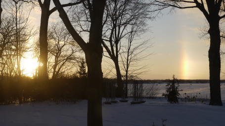 Sundog.
 I captured this photo a few days ago at sunset, a vivid "sundog" on the right - the result of white sunlight being refracted (bent) by tiny hexagonal (plate-like) ice crystals - which behave like prisms - into the colors of the rainbow. More than you ever wanted to know about "parhelia" and sundogs (which are only visible near sunrise and sunset)
here and
here.
Paul's SC Times Outlook for St. Cloud and all of central Minnesota:
TODAY: Turning cooler, mostly cloudy with flurries. Winds: NW 8-13. High: 23
SATURDAY NIGHT: Patchy clouds, getting colder. Low: 6
SUNDAY: Clouds, light snow develops at night - couple inches possible. High: 15
MONDAY: Worst travel day of the week. Periods of snow possible, possibly "plowable", snow totals in the 2-4" range possible. Low: 5. High: 17
TUESDAY: Numbing sunshine, better travel conditions. Low: -8. High:5
WEDNESDAY: Partly cloudy, more goosebumps. Low: -12. High: 8
THURSDAY: Mix of clouds and sunshine, space heater still turned on. Low: -7. High: 7
FRIDAY: Clouds increase, not quite as bitter. Low: 0. High: 17
"Larry Sprinkle"
Paul Douglas is an "air name", forced on me in 1975, when I was doing weather reports for a little AM radio station. "If you want to get a $25 check every week you'll change your name, so our DJ's don't get confused. Most of them can't even say their own names!" the station manager confided. It just sort of stuck. Some days I'm "Doug", much of the time I'm "Paul". I never know how to introduce myself. It's complicated.
True: there's a Larry Sprinkle doing TV weather in Charlotte. Dallas Raines tracked storms (or a lack thereof) in L.A. Amy Freeze predicts lake effect for FOX/Chicago. Karl Spring in Duluth, Storm Fields in New York - where does it end?
I can get away with this rant because there's no real "weather". We cool down over the weekend - the arrival of Arctic air may set off a few inches Sunday night and Monday, possibly enough to plow and shovel in the St. Cloud metro area. Latest models are hinting at something in the 2-4" range, maybe more south/west. Dig out the heavy coats: single digit highs and 3-4 subzero nights next week; not as cold as last week, but cold enough to get your attention. No sign of an early spring or an extended thaw. If this keeps up I may have to change my name (again). I was thinking Paul Thunder. Maybe "Doppler Douglas"? Too much free time. Sorry.
Monster Snowstorms Spell Global Warming. CNN interviews Michio Kaku, professor of theoretical physics at City College of New York, about the recent onslaught of major snowstorms (5 of the largest snowstorms of the last 142 years in the Big Apple have come in the last decade). An excerpt from the CNN
interview: "
Among many factors, the amount of snow dumped is largely driven by the amount of moisture in humid air and not so much the temperature, and this seems to go against common sense. (For example, if we are making ice cubes, the amount of water in the ice tray, not the temperature, determines how much ice we can make. If we crank down the temperature dial in our freezer, this simply makes the ice freeze faster but does not increase the amount of ice produced.) There is no single smoking gun that can point us to the origin of these monster snowstorms. But we can focus our attention on two likely culprits. The first is pure chance. There are many random fluctuations in the weather due to many diverse factors (for example, last year's weather was affected by El Niño). But the second is global warming. This also seems to violate common sense, but realize that global warming can heat the oceans and generate more moisture, which in turn can drive larger storms. Last year was, in fact, tied with 2005 as the hottest year recorded since 1880, when precise measurements began."
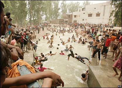
Soaring Mercury In January Indicates Global Warming. It's been a cold winter for much of the USA, but elsewhere temperatures have been freakishly warm, from eastern Canada and Greenland to India. The Times of India
reports on the unusually warm weather observed in recent weeks: "
ALLAHABAD: Sanjeev Upadhaya arrived in the city on Thursday from Hyderabad. Expecting a chilly weather, Sanjeev's luggage was stacked with woollen clothes. However, much to his surprise, the Hyderabad native found the weather here quite warm and rued carrying so many woollen clothes. The sudden rise in temperatures has baffled many. Just a fortnight ago, the north India was reeling under severe cold wave, with temperatures hovering between 0 and three degrees. And now, the day temperature is touching 30 degrees Celsius. This, when January is not yet over. The unusual rise in the mercury indicates towards a changing global phenomenon -- shirking winters and expanding summers."
Green-Fatigue Grows As Number of Climate Skeptics Doubles. The deniers are doing a good job and sowing "FUD", fear, uncertainty and doubt. That, and a snowy winter, which continues to confuse many about the difference between short-term weather patterns, and long-term (decade-length) climate trends. Here's an excerpt from a
story at the U.K's clickgreen.org: "
The number of Britons who are unconvinced that climate change is a reality has nearly doubled in recent years, according to a UK government survey. The poll reveals that more than a quarter of the country remain unconcerned about climate change despite huge awareness campaigns and the roll-out of an ambitious renewable energy programme. Levels of belief in and concern about climate change have been falling since the introduction of the survey in 2006. The proportion of adults who were at least ‘fairly concerned’ about climate change has fallen from 81% in 2006 to 70% in 2010. The survey, carried out by the Office for National Statistics, has plotted levels of acceptance of the theory of man-made global warming since 2006.
• In 2010, only 75% of respondents were at least ‘fairly convinced’ that the world’s climate is changing, falling significantly from 87% in 2006.
• The proportion of respondents who were at least ‘fairly concerned’ about climate change has fallen from 81% in 2006 to 70% in 2010.
• In 2010, 72% of respondents said they were willing to change their behaviour to help limit climate change, down from 77% in 2006.
Running Out Of Time On Climate Change: Ban Ki-Moon. Outlook India has a
story quoting the U.N.'s Secretary General: "Warning the world that time is running out fast for addressing climate change issues, the UN today said the current economic development model is akin to a "suicide pact". "We need a revolution. We need revolutionary change, revolutionary action. We need a free market revolution for global sustainability," United Nations Secretary-General Ban Ki-moon told the participants in the annual WEF meeting here. The days of consumption without thought are over, Ban cautioned saying "climate change is rendering the old model obsolete. The old economic model now amounts to a global suicide pact". The Secretary-General further said ways must be devised to manage scarce resources. "We are running out of time on climate change, on clean energy," he said, adding that developing a sustainable growth agenda has become "the agenda for the 21st century". "Together we need to tear down the walls between a green agenda and a growth agenda. There is no time to waste," he said."





No comments:
Post a Comment