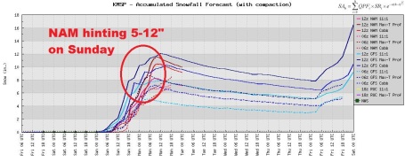
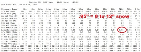
The latest computer run looks even more impressive for significant snow on Sunday. Latest models print out over an inch of liquid, which (if it verifies) would work out to 10-14", give or take. Bottom line: significant (wet) snow is likely Sunday, try to get your errands done on Saturday, the probervial calm before the storm.
* No travel problems tomorrow, dry roads as clouds increase ahead of the storm.
* Wet snow begins late Saturday night - the heaviest snow should fall Sunday afternoon and evening, possibly at the rate of nearly 1"/hour at times.
* Probably cold enough for all snow in St. Cloud, although a little ice can't be ruled out Sunday morning.
* Winter Storm Watch has now been issued for the St. Cloud metro and much of central and southern Minnesota.
* Potential for significant icing across southern Minnesota, especially south of a line from Mankato to Red Wing.

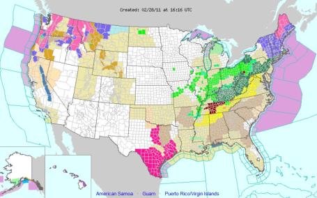
Winter Storm Watch. The local NWS office has issued a winter storm watch (meaning a potential for 6"+ snow) for central and southern Minnesota, and a chunk of west central Wisconsin. It means conditions are ripe for a storm capable of interfering with travel - the bulk of the snow scheduled for Sunday and Sunday night. All those green counties are under flood warnings, the result of the recent thaw and rapid snow-melt across the Upper Midwest.
"A WINTER STORM WATCH HAS BEEN ISSUED FOR SOUTH AND CENTRAL MINNESOTA AND WEST CENTRAL WISCONSIN FOR HEAVY SNOW IN THE 5 TO 10 INCH RANGE. A PERIOD OF MIXED PRECIPITATION...INCLUDING FREEZING RAIN OR SLEET...IS ALSO POSSIBLE EARLY IN THE STORM. THE BEST CHANCE FOR THIS WINTRY MIX AND ICE ACCUMULATIONS WILL BE NEAR OR SOUTH OF A LINE FROM REDWOOD FALLS...TO LE SUEUR...TO RED WING. IN ADDITION TO THE WINTRY PRECIPITATION...STRONG WINDS ARE EXPECTED TO DEVELOP SUNDAY AFTERNOON AND EVENING. THIS COULD CREATE AREAS OF BLOWING AND DRIFTING SNOW. THERE IS STILL SOME UNCERTAINTY AS TO THE PRECISE TRACK OF THIS SYSTEM... ESPECIALLY WITH RESPECT TO THE AMOUNT OF WARM AIR THAT WILL BE DRAWN INTO THE AREA...WHICH WILL AFFECT THE PRECIPITATION TYPES AND SNOWFALL ACCUMULATIONS. HOWEVER...WE ARE GAINING MORE CONFIDENCE THAT A LARGE AREA WILL SEE HEAVY SNOW ON SUNDAY. STAY TUNED TO FUTURE UPDATES AND FORECASTS FOR FURTHER DETAILS ON THIS APPROACHING WINTER STORM."

Dueling Models. There is still a fair amount of disagreement between the various models, but 8-12" would be a good mid-range right now, with an outside chance of 12-14", especially north of St. Cloud.

The latest 12z NAM model (probably the most reliable, although they all have their good days and bad days) is printing out .95", but closer to 1.42" for St. Cloud. If it's all snow (possible) we could wind up with 8-12" heavy, wet, slushy snow by Sunday night. Hey, at least it's coming on a weekend, right?

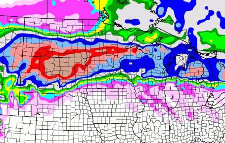
Marchlike Snowstorm. The NAM model prints out the heaviest snow amounts from the Dakotas into central and northern Minnesota, as much as 10-16" toward Brainerd, Bemidji and Duluth, with lesser amounts south, closer to the metro area. This may be an ice storm across far southern Minnesota, from Mankato to Rochester to the Iowa border.
No comments:
Post a Comment