13" snow on the ground as of Monday evening.
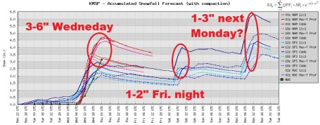
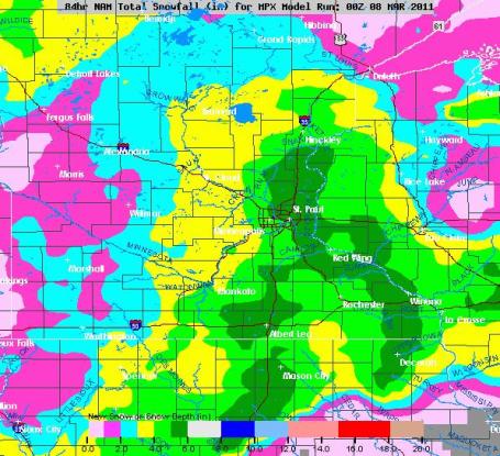
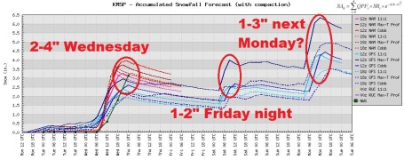
1-3" snow expected Wednesday, as much as 5" south/east of St. Cloud. Heaviest snow falls Wednesday morning.
1-2" slush possible Friday night.
1-3" more next Monday.
* National Weather Service may extend the Winter Storm Watch into parts of the Twin Cities metro today.
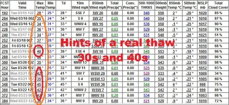
40s likely the third week of March. There are some (subtle) signs of spring in the long-range models.
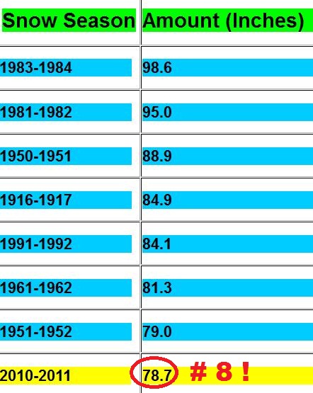
* According to Greg Spoden over at the Minnesota State Climatology Office, 10 of the last 15 La Nina winters have resulted in over 20" snow for the Twin Cities area. If that's the case this year we'll come very close to breaking the all-time snowfall record of 98.6" in 1983-84. How does the saying go, "may you live in interesting times?" A little too interesting.
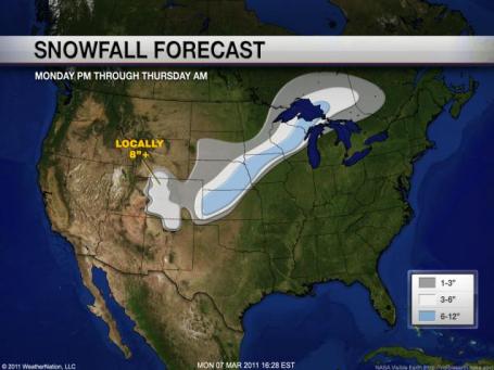


Trending Upward. Every computer run takes the storm track a little farther north and west (remember the "southward bias" I warned you about with the GFS model?) It turns out last week's projections may have been more accurate than what the GFS was printing out just 1-2 days ago. So it goes with long-range guestimation. Bottom line: the odds of 5 or even 6" of snow in the metro have increased. It won't be Snowmageddon, but Wednesday will probably be a slushy mess.

00z NAM/WRF Solution. .36" liquid by Thursday morning in St. Cloud; that's almost twice as much as the NAM was suggesting 48 hours ago. It turns out the southern storm may (in fact) take a more northward jog, heavier snow bands pushing into the immediate St. Cloud metro area, possibly enough for 1-3" close to home. I wouldn't be surprised to see some 3"+ amounts by late Wednesday night, especially south/east, toward Monticello and Elk River.

Cobb Method. With a snow/rain ratio ranging from 11:1 to 16:1 the Twin Cities metro area may wind up with as much as 4-5". Not exactly the end of the world - but enough to complicate your Wednesday just a bit.
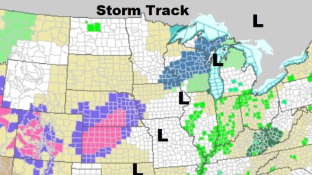
Forecast discussion from the local NWS office:
THE MAIN FORECAST CONCERN DEALS WITH THE UPCOMING STORM SYSTEM
THAT WILL AFFECT MAINLY THE SE 1/2 OF OUR FA WITH SIGNIFICANT
SNOWFALL. HOWEVER...IT DOES NOT APPEAR TO BE AS HEAVY THAN IN
PREVIOUS DISCUSSIONS BASED ON INITIAL DRY LAYER /EASTERLY FLOW/ AT
THE START AND SFC LOW PROGRESSION WHICH FAVORS FAR SE MN WITH THE
HEAVIEST SNOW BANDS. CURRENT WSW SEEMS REASONABLE DUE TO THESE
FACTORS MENTIONED ABV. HOWEVER...STRENGTH OF THIS SYSTEM REMAINS
FAVORABLE FOR A BROAD AREA OF 4+ FROM FAIRMONT...TO THE TWIN
CITIES METRO AREA...AND MUCH OF WEST CENTRAL WISCONSIN. 6+ TOTALS
SEEM REASONABLE FOR AREAS FROM ALBERT LEA TO RED WING...TO
LADYSMITH WISCONSIN AND SOUTHWARD. BASED ON FRONTOGENETIC
FORCING/UPPER AIR DIFLUENCE  AND SFC REFLECTION...THE HEAVIEST
SNOWFALL WILL LIKELY OCCUR SOUTH OF OUR FA...WITH ROCHESTER TO
LA CROSSE COMMUNITIES LIKELY EXPERIENCING HEAVY BANDS OF SNOWFALL
DURING THE HEIGHT OF THE STORM.

Trending In The Right Direction. The GFS model shows temperatures trending a little closer to average over the next 15 days, highs consistently above freezing after March 14 or so. One more cold snap is likely this upcoming weekend, but nothing subzero is in sight. We may have seen our last subzero night of the winter season.


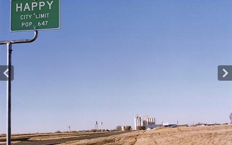
U.S. Farmer Fear The Return Of The Dust Bowl. Underground aquifers are being depleted at a rapid rate across the Great Plains; there's growing concern about water supplies, especially over the central and southern Plains. Here's a story summarizing a growing sense of agricultural paranoia from the U.K.'s Telegraph: "There is not much to be happy about these days in Happy, Texas. Main Street is shuttered but for the Happy National Bank, slowly but inexorably disappearing into a High Plains wind that turns all to dust. The old Picture House, the cinema, has closed. Tumbleweed rolls into the still corners behind the grain elevators, soaring prairie cathedrals that spoke of prosperity before they were abandoned for lack of business. Happy's problem is that it has run out of water for its farms. Its population, dropping 10 per cent a year, is down to 595. The name, which brings a smile for miles around and plays in faded paint on the fronts of every shuttered business – Happy Grain Inc, Happy Game Room – has become irony tinged with bitterness. It goes back to the cowboy days of the 19th century. A cattle drive north through the Texas Panhandle to the rail heads beyond had been running out of water, steers dying on the hoof, when its cowboys stumbled on a watering hole. They named the spot Happy Draw, for the water. Now Happy is the harbinger of a potential Dust Bowl unseen in America since the Great Depression. 'It was a booming town when I grew up,' Judy Shipman, who manages the bank, says. 'We had three restaurants, a grocery, a plumber, an electrician, a building contractor, a doctor. We had so much fun, growing up.' Like all the townsfolk, she knows why the fun has gone. 'It's the decline in the water level,' she says. 'In the 1950s a lot of wells were drilled, and the water went down. Now you can't farm the land."
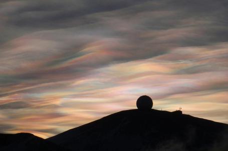
Recent Scenes From Antarctica. "Nacreous Clouds over the NASA Radome (a weatherproof structure housing a 10 meter antenna inside). Nacreous clouds (or Polar stratospheric clouds) form high in the dry stratosphere, catching sunlight well after dusk, displaying brilliant colors. Original here. (Alan R. Light / CC BY). The Atlantic has a remarkable story with incredible photos from Antarctica: "Winter is coming back to Antarctica and, after a busy season for both scientists and tourists, most researchers stationed there have traveled north for the season. Among them were a Russian team that recently came within 30 meters of drilling into Lake Vostok -- a subglacial lake some 4,000 meters below the surface of the ice -- and the crew of the IceCube Neutrino Observatory, who have been burying a massive array of detectors deep in the ice. (They placed their final detector in December.) Gathered here are recent images of Antarctica, its environment, and some of the scientific work taking place there."
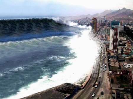
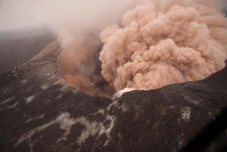
New System Can Warn Of Tsunamis Within Minutes. O.K. Tidal waves are one of the few things (along with volcanoes and earthquakes) we don't have to worry about here in Minnesota. Physorg.com has details on a new warning system that could make a real difference for coastal residents, worldwide: "Seismologists have developed a new system that could be used to warn future populations of an impending tsunami only minutes after the initial earthquake. The system, known as RTerg, could help reduce the death toll by giving local residents valuable time to move to safer ground. The study by researchers at the Georgia Institute of Technology appears in the March 5 edition of Geophysical Research Letters. "We developed a system that, in real time, successfully identified the magnitude 7.8 2010 Sumatran earthquake as a rare and destructive tsunami earthquake. Using this system, we could in the future warn local populations, thus minimizing the death toll from tsunamis," said Andrew Newman, assistant professor in the School of Earth and Atmospheric Sciences. Typically, a large subduction zone earthquake ruptures at a rate near 3 kilometers/second and anywhere from 20 kilometers to 50 kilometers below the earth's surface. Because of the depth, vertical deformation of the crust is horizontally smoothed, causing the size of uplift to remain rather small. When these earthquakes occur in the ocean, the resulting waves may only measure about 20 centimeters high for a magnitude 7.8 event. Tsunami earthquakes, however, are a rare class of earthquakes that rupture more slowly, at 1-1.5 kilometers /second and propagate up to the sea floor, near the trench. This makes the vertical uplift much larger, resulting in nearby wave heights up to 10- 20 meters in nearby coastal environments. Such is the case of the Sumatran earthquake with reported wave heights of up to 17 meters, causing a death toll of approximately 430 people."


Sample Letter
To email or call Speaker John Boehner
http://www.speaker.gov/Contact/
To email or call Representative Eric Cantor
http://cantor.house.gov/contact/
Contact your representative - we need (an intact) National Weather Service, now more than ever.
Facebook. Show your support of the NWS by leaving a message on FB. Click here to learn more.
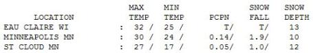
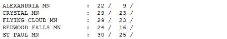
Gray Monday. What happened to "average"? The average high for March 7 is 36 F, according to the National Weather Service. Last year it was a balmy 47 F. on March 7 (we saw 60s by mid March). Seems like a different planet. Under a gray sky the mercury only hit 22 at Alexandria, 27 in St. Cloud and a brisk 30 in the Twin Cities. Nearly 2" snow fell Sunday night at MSP, an inch in St. Cloud. More climate data than you can possibly know what to do with here.
Paul's SC Times Outlook for St. Cloud and all of central Minnesota:
TODAY: Cloudy. Light snow possible by evening over far southern MN. Winds: E 15. High: 34
TUESDAY NIGHT: Snow becomes steadier, 1" possible by daybreak Wednesday. Low: 27
WEDNESDAY: Potential for 1-3" snow, heavier amounts south/east of St. Cloud. Heaviest snow falls Wednesday morning. Road will be slushy and slippery. High: 30
THURSDAY: Sun returns, easier commutes. Low: 21. High: 33
FRIDAY: A little rain, possibly ending as wet snow, maybe 1-2" at night. High: 36
SATURDAY: Snow tapers to flurries, gusty. Low: 24. High: 30
SUNDAY: Sunny start, clouds increase. Snow possible Sunday night. Low: 19. High: 33
MONDAY: Snow early (inch or so?), drying out PM hours. High: 35
Snow Tales
"It's spring fever. That is what the name of it is. And when you've got it, you want - oh, you don't quite know what it is you do want, but it just fairly makes your heart ache, you want it so!" wrote Mark Twain. Yes, we ALL want it so.
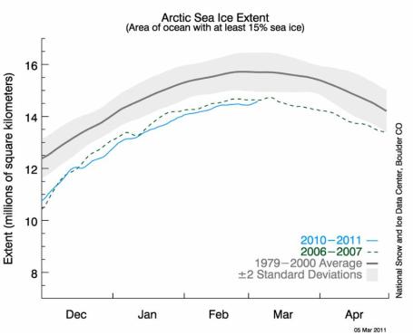
First, the good news: I think we've seen our last subzero night in the Twin Cities (total of 18, well below the winter average of 28). By the 3rd week of March we should see consistent 30s and 40s; a higher sun angle making a difference, in spite of a stubborn La Nina. And, we've gotten our "Winter Weather Boasting Rights" back. At 78.7" this is the 8th snowiest winter since 1891. If we pick up 3-5" by Saturday we'll be at #6, with a 1 in 3 shot of breaking the all-time record of 98.6", set in 1983-84. I didn't think we'd EVER break that one.
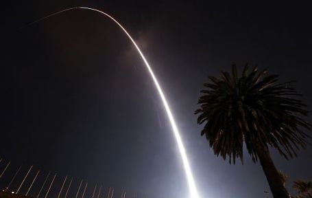
Serious Set-Back For Climate Science. NASA's "Glory" weather and climate satellite was destroyed before reaching low-orbit last week. It was scheduled to track aerosols and their impact on Earth's climate system, the loss of the satellite will inevitably delay important data on how these aerosols impact the overall climate system. Climate scientist Scott Mandia has more on the loss of Glory, and what it means for NASA and climate research:
"On Friday (March 4, 2011), the Glory satellite failed to reach escape velocity and crashed to Earth. In a recent reply to a news reporter, Dr. Bruce Wielicki of NASA eloquently described NASA’s role in studying climate and why the loss of this satellite was a huge setback for climate science. Dr. Wielicki has graciously allowed me to repost his response here. “Your questions are good ones and I’ll try to put them in context. First: who am I? I have been a co-investigator or lead investigator on NASA Earth Science missions since 1980: ERBE, CERES, CALIPSO, CloudSat, CLARREO. So I am very familiar with space missions in general and climate missions (all of the above) in particular. If you need more details they are in the attached resume. The loss of the Glory satellite is a tragedy for climate science. The Glory satellite included two critical instruments: one to monitor the total energy reaching the Earth from the Sun, and a second to unravel some of the key remaining mysteries about tiny particles called aerosols: especially about the aerosols that humans emit when we burn fossil fuels in cars, power plants, or our homes. Aerosols remain one of the key uncertainties in how fast our fossil fuel burning is pushing the climate system to warmer levels. So the Glory mission was a key part of understanding how both natural (Sun) and human (aerosols) forcings are acting to change our current and future climate."

Waxman Takes On The "Science Deniers". A Congressional hearing this morning will pit 2 leading climate scientists against two well-known skeptics. Is it possible to legislate climate change away - maybe sweep it under the rug and hope that things go well long-term? Not if Congressman Henry Waxman has anything to say about it. From a story in the New York Times: "Mr. Waxman, the erstwhile chairman of the House Energy and Commerce Committee and now the ranking Democrat under its new Republican leadership, is fighting a rearguard action on behalf of health, telecommunications, energy and environmental legislation passed in the last Congress, when Democrats held the majority and he wielded the gavel of arguably the most powerful committee in Congress.....Mr. Waxman concluded his remarks by comparing the climate change issue to the civil rights struggles of the 1960s. “We are at a pivotal time in which every member of Congress will decide whether they will be on the right side of history or the wrong side of history,” Mr. Waxman said. “Civil rights in the 1960s was a moral issue, and there was a right side and a wrong side. Climate change is an environmental issue. It is an economic issue. But it is also fundamentally a moral issue.” He warned that if policy makers do not recognize the seriousness of the threat of climate change and fail to act, “history will not judge us kindly.”
No comments:
Post a Comment