* Cold rain changes to sleet this evening; mostly (wet) snow after 10 pm.
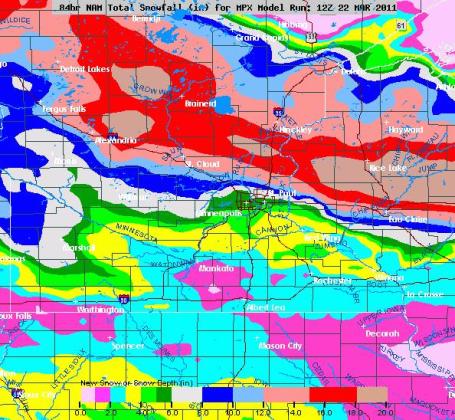
* Band of 6-10" possible from Alexandria, St. Cloud and Brainerd Lakes area east to Cambridge and Taylors Falls. Some towns may see close to a foot.
* Winter Storm Warning in effect from St. Cloud on north to Little Falls and Brainerd.
* The farther north you drive tonight and Wednesday the heavier the snowfall amounts.
* Blizzard warnings still posted for Duluth area for as much as a foot of snow by Wednesday PM.
* Most of the snow that does fall will be gone by Thursday or Friday - the sun is too high in the sky for snow to linger on the ground for long.

Cobb Method. The latest NAM numbers are hinting at over 10" snow for St. Cloud by Wednesday afternoon. This may be (a little) high, but I still suspect that a 6-10" range is reasonable, based on the guidance, which has been fairly consistent for the last 48 hours.
No comments:
Post a Comment