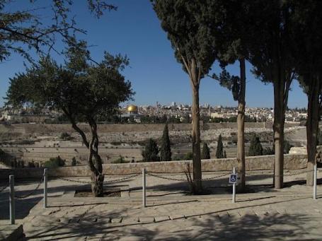
Jerusalem. My wife and I flew to Israel for a few days before Christmas; I took this picture of the Old City from the Mt. of Olives. Since it's a slow weather day - and Easter Sunday - I've included a few more photos of our trip to Jerusalem below.
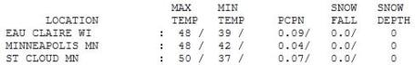
.12" rain predicted for St. Cloud Tuesday (NAM model). 1.11" rain predicted for the Twin Cities.
50 F. high on Saturday in St. Cloud (average high for April 23 is 59 F).
60 F. predicted high later today under a partly sunny sky.
62 F. predicted high on Monday.
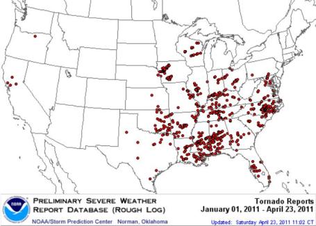
559 tornadoes so far in April. This is a preliminary count based on eyewitness reports. The final count will almost certainly be lower.
We've Been Lucky. Yes, it's been miserably cool in recent weeks - we're all waiting for spring, but there is a silver lining to our cool spell: the most violent thunderstorms (which need warm, moist air to grow into "supercells") have tracked just south/east of Minnesota. The red dots are confirmed tornado touchdowns, 49 in Iowa, 19 so far in Wisconsin. no confirmed tornadoes in Minnesota - yet.
Data courtesy of SPC, the Storm Prediction Center.
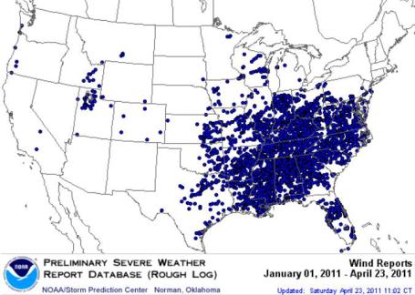
Damaging Wind Reports. The cluster of high wind reports east of the Mississippi River is striking, so far 4,370 individual reports of damaging winds.
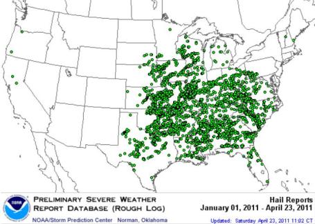
Damaging Hail Reports So Far In 2011. To be considered severe, hail has to be at least 1" in diameter, roughly quarter-size. So far this year there have been 3,199 separate reports of damaging hail (only 6 of those in Minnesota).
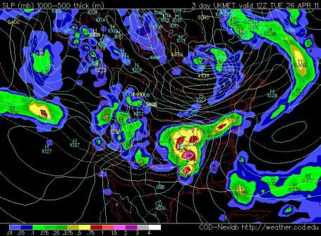
Tuesday Soaker? The UKMET model valid 7 am Tuesday morning shows an intense area of low pressure centered over central Iowa. As much as an inch or more of rain may fall. The good news: the atmosphere overhead should we warm enough for rain. I can't believe I have to put that into writing on the 24th day of April, but after the winter we just endured I (like you) take NOTHING for granted.
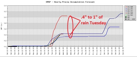
Rain Trends. Earlier runs were suggesting only .4" of rain or so on Tuesday, but the most recent (00z) NAM run prints out over 1" of rain Tuesday and Tuesday night, pulling the storm track closer to Minnesota. Either way Tuesday looks like the wettest day of the week.
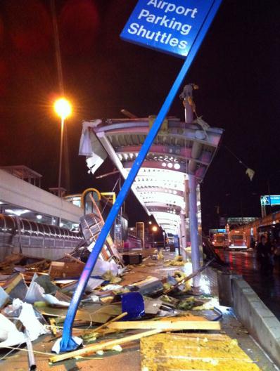
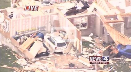
STL International Airport. A major disaster was narrowly averted Friday evening when an EF-4 strength tornado, winds approaching 175 mph, struck the northwest suburbs of St. Louis, including Lambert Airport. An estimated 700+ homes were damaged or destroyed in 9 communities. Scores of people were injured by flying glass and other debris, but (miraculously) there have been no reports of fatalities. That's a testament to good luck, good planning, and an estimated 20 minute warning, leaving plenty of time for people to find shelter. The average lead time for a tornado warnings in the USA is closer to 12 minutes, nationwide, according to NWS statistics. Photo credit: "Destruction at Lambert Airport; photo by @EmilyRasinski", courtesy of
twitpic.
Close Call. Check out the
raw video of tornado winds swirling throught the terminal of St. Louis Lambert Airport as passengers and airport authorities scramble for shelter. Not a moment to soon. Video courtesy of WMOV-TV in St. Louis.
St. Louis Tornado Videos. Click
here to see more videos of the EF-4 tornado that hit the northwestern suburbs of St. Louis Friday evening, courtesy of breakingnews.com.
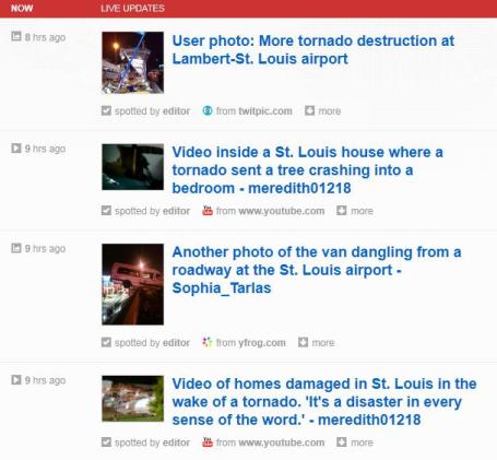
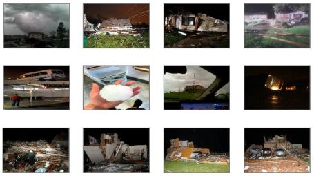
Storm Summary. The St. Louis office of the National Weather Service has a
good overview of Friday's tornadoes, including extensive photographs of the storm and aftermath: "
A tornadic supercell crossed the Greater St. Louis Metropolitan Area with many reports of large hail and damage from New Melle in St. Charles County to Granite City in Madison County, Illinois. Some of the most intense damage occurred in St. Louis County across Maryland Heights, Bridgeton, St. Ann, Edmundson, Lambert St. Louis International Airport, Berkeley, and Ferguson. Several people were injured by flying debris and glass at the main terminal of the airport. The National Weather Service will be surveying the tornado damage over the weekend to determine the number and intensity of tornadoes that occurred. Below are some pictures of the strom and damage that have been collected from local news outlets."
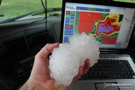
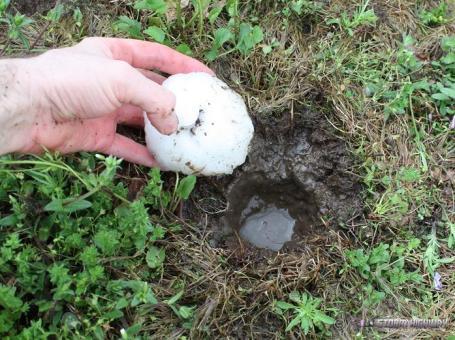
Softball - Grapefruit Size Hail. Yes, this could put a definite crimp in your day (or your car's finish). Good grief. These are the 4-5"+ diameter hailstones that fell out of the sky northwest of St. Louis - the same "supercell" thunderstorms that spun up an EF-3 or EF-4 tornado had an updraft violent enough to keep massive hailstones aloft. Again, the larger the hail, the stronger the thunderstorm updraft, the greater the potential for a tornado. Details from
stormhighway.com.
Hail "Crater". These softball-size hailstones probably hit the ground at 80-100 mph, leaving behind thousands of tiny "craters" in the soggy soil. "Honey, I'm going to put my football helmet on and go out to get the mail." Amazing.
Investments In Storm Safety. North Carolina's newsobserver.com has the
story: "
SILVER SPRING, Md. -- As the director of the National Weather Service, I was saddened to see so many people lose their lives during the tornado outbreak last week. As communities across North Carolina and other storm-ravaged parts of the country clean up and heal, there are stories of survival that provide some solace and even inspiration during this difficult time. There are also valuable lessons that I want to offer to help prevent such devastating losses of life during future storms. The sprawling storm that confronted us dropped tornadoes from Oklahoma to the Carolinas. We've seen powerful and deadly tornado outbreaks like this before; so, we were able to issue forecasts days before the devastation. Hours before the storms hit we placed communities under a watch, meaning conditions were favorable for severe thunderstorms and tornadoes. And when tornadoes began to form, National Weather Service warnings urged residents to seek shelter immediately, providing a life-saving alert 23 minutes, on average, and in some cases upwards of an hour before the tornadoes arrived."
One Hurricane Away From $6/gallon Gas? Here's an
uplifting article from WLS-AM radio in Chicago: "
(NEW YORK) -- If you think gas prices are high at the moment, one expert says ‘just wait.’ “Six dollar gas is probably one well-placed hurricane and one tiny little bit of supply disruption away,” says consumer strategist Richard Hastings. If the dollar continues to weaken and hurricane season is severe, gas prices, Hastings says, could go through the roof. “Put everything together and a little bit of a supply disruption and you could easily see a brief period where prices could go up to about $6.50 a gallon, no problem,” he said. Hastings believes the national average for a gallon of gas could reach $4.45 by late summer."
A Clash Over The Airwaves. The New York Times has a
story about a brewing battle between TV broadcasters (who hold valuable over-the-air "spectrum") and the FCC and wireless carriers, who want that additional spectrum for wireless devices. This will be an epic struggle, and one thing is certain: the lawyers will win. Can you say "billable hours?" "
LAS VEGAS — Dropped calls. Maps that take eons to load. Echoing voices on a mobile phone. And, as iPhone users know, the dreaded “Cannot Open Page.“ Those annoyances are likely to get worse, as airwaves that carry cellphone signals and wireless Internet connections grow ever more crowded. The Federal Communications Commission
has a solution: reclaim airwaves from “inefficient“ users — specifically, television broadcasters — and auction them off to the highest bidder, sharing some of the proceeds with television stations that volunteer to give up airwaves, known in the trade as spectrum. Broadcasters, however, are furious with the plan, setting the stage for an old media vs. new media lobbying battle with cellphone companies and the government. “We’re in full battle mode to protect broadcasters from being forced to give up spectrum,“ said Gordon H. Smith
, president of the National Association of Broadcasters and a former United States senator, addressing his members at their meeting here last week. The CTIA, the lobbying group for the wireless industry, quickly fired back, accusing broadcasters of “desperate and inaccurate stall tactics,” said Steve Largent
, the group’s president, who is a former Oklahoma congressman and member of the Pro Football Hall of Fame."
Ragged Saturday. Yes, it was a murky, breezy and damp Saturday, but at least the showers and sprinkles dried up by late morning, a few rare sunshine sightings later in the day. All those clouds kept temperatures cooler. Where the sun peeked through temperatures were a few degrees warmer:
50 at St. Cloud and 51 at Alexandria.
Paul's Easter Travelogue: forgive me, but I thought this might be as good a time as any to include a few photos taken during a December trip to Israel - the first time my wife and I had visited the Holy Lands. No matter what your faith I highly recommend taking a trip to Jerusalem. There is no other city like it on the planet, a holy place for Christians, Jews and Muslims alike.
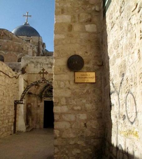
Church of the Holy Sepulchre. Built on the site where Christ was crucified, the (massive) Church of the Holy Sepulchre is divided into different quarters: Catholic, Armenian, Greek Orthodox and Ethiopian.
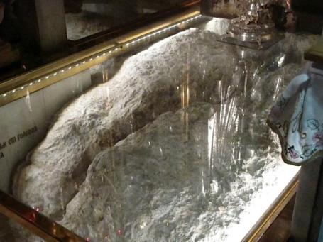
Calvary. The Altar of the Crucifixion. It's more than surreal when you stand in front of the rock that, according to tradition, is the site where Jesus was crucified. You can even reach down and touch the stone that held the cross. For Christians it's a deeply moving and emotional experience.
The Tomb. The "Aedicule" is a smaller shrine within the main church that contains the burial place of Christ. Greek Orthodox monks guard the door, and let people in, 3 or 4 at a time, into the small chamber that contains the rock slab where Christ's body was placed after crucifixion.
Inside The Tomb. No, I didn't dare take out my camera - this is from a
Wikipedia article about the Church of the Holy Sepulchre, which has a lot of interesting information about the church and it's history over the last 2,000 years.
Paul's SC Times Outlook for St. Cloud and all of central Minnesota:
EASTER SUNDAY: Rare sunshine sightings. Much better. Winds: SW 10. High: near 60
SUNDAY NIGHT: Partly cloudy and quiet. Low: 40
MONDAY: Sunny start, clouds increase. Still mild. High: 62
TUESDAY: Cold rain expected, heavy at times. Low: 43. High: 52
WEDNESDAY: More clouds than sun, a drier day. Low: 38. High: 57
THURSDAY: Sun early, shower possible late. Low: 40. High: 62
FRIDAY: Fading sun, showers/storms possible late. Low: 44. High: 65
SATURDAY: Damp start, then some sun, breezy. Low: 47. High: 59
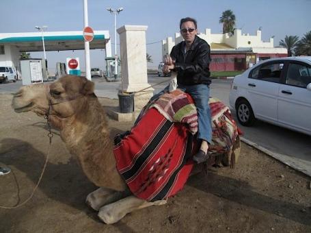
Funny Looking Creature. And who's that camel loitering at the gas station/tourist trap on the way to the Dead Sea?
Happy Easter!
The EF-4 (!) tornado that hit St. Louis's Airport had 20 minutes warning. 9 days ago the monster "wedge" tornado that hit Tushka, Oklahoma had over 50 minutes lead time, which is remarkable. The system works; the combination of Doppler radar (capable of detecting rotating storms), trained weather spotters on the ground, and a streamlined National Weather Service warning system has saved many lives in recent weeks.
A generation ago the average advance lead time for tornadoes was 6 minutes. An airport terminal is especially vulnerable, surrounded by glass with high ceilings (and little or no access to an underground shelter). Situational awareness is key: stay alert, sign up for warnings on your cell phone.
The atmosphere overhead will remain too cool and stable for anything severe the next week, the next chance of a cold rain Tuesday. The sun comes out today and Monday, highs topping 60. Hallelujah!
Four months ago my wife and I toured Israel, spending time in Jerusalem. We retraced the last steps of Christ and saw his tomb at the Church of the Holy Sepulchre. Surreal, and deeply moving. Looking for a life-altering trip? See the Holy Lands. It will change you forever.
Longtime Minnesota TV Reporter Digs Into Global Climate Change. The Duluth New Tribune has a
story about Don Shelby, and the evolution of his reporting on climate change over the last 20 years: "
After spending 32 years in front of the camera as an anchorman and investigative reporter for WCCO-TV in Minneapolis, Don Shelby wanted to apologize to people about climate change. “For those of you who are confused on this issue,” he said, “you’re forgiven. It’s my fault.” Shelby was speaking at the University of Minnesota Duluth on Tuesday on what he called “The most important story since journalism began — global climate change.” His speech served as the kick-off for a two-day sustainability fair sponsored by UMD’s Office of Sustainability. The TV newsman’s mea culpa about having misreported climate change came after of years of treating the story the same as he would any other, requiring the views of two opposing parties, Shelby told the packed lecture hall of the chemistry building. But, he said, climate change is not a pro or con issue; it’s a scientific fact. And journalists who work to “balance” a story present an inaccurate picture when they give equal weight to sources promulgating inaccurate facts."
* I remember a time, when Don Shelby and I were both working together at WCCO-TV around 2000, when Don was skeptical about climate change. I spent several months bringing him up to speed on the state of climate science, and over time, Don began to understand the ramifications of dumping 9 billion tons of carbon into the atmosphere annually, worldwide. Will Steger's personal experiences in the Arctic were also important data points for Don, his first-hand observations of changes in the last 30 years were hard to refute. Journalists are taught to be objective, to give "equal time" to both sides of an argument. All the various theories (sun, water vapor, etc) have been extensively tested, other possible explanations for the global changes we're witnessing, ranging from shrinking glaciers and polar ice to rising sea levels and an apparent spike in extreme weather events - the most likely explanation is the 38% spike in greenhouse gases. If anything these changes are taking place faster than computers predicted in the 1980s and 1990s. The science is the science, and now Don is focusing his efforts on educating the public, and working with the nation's leading climate scientists, taking a highly complex scientific story and helping them communicate what's happening to the public.
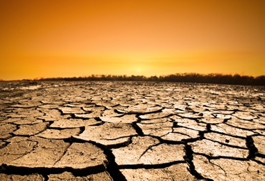
. The New York Times has a
story about perpetual drought in the Lonestar state. Some are beginning to wonder if the (ongoing) dry spell is a fluke, or a trend. For 20+ years supercomputer simulations have predicted a much hotter, drier climate for Texas. That forecast is coming true: "
The severe drought across Texas has hit the oil and gas city of Midland especially hard, as I reported in Friday’s New York Times and Texas Tribune. Since Oct. 1, Midland has received only 0.13 inches of rainfall — making it “most likely the driest six-and-a-half-month period in recorded history,” said David Hennig, a Midland-based meteorologist with the National Weather Service. With three major regional reservoirs ranging 2 percent to 30 percent full, the city has put in place outdoor watering restrictions — albeit not backed up by penalties — for the first time. Texas weather experts attribute this drought to the Niña effect. Some observers are wondering whether it is also related to global warming, though that’s a delicate question in Texas, the only state refusing to carry out greenhouse gas regulations recently introduced by the Environmental Protection Agency. Gov. Rick Perry, who just issued a proclamation urging prayers for rain this weekend, has said that the climate is always changing but that it is not clear that humans are affecting it. John Nielsen-Gammon, the Texas State climatologist, says that about 80 percent of the models laid out by the Intergovernmental Panel on Climate Change in a 2007 report predicted declining precipitation for Texas, but on the other hand Texas has gotten increasing rainfall from 1895 to the present. The reason for this difference is unclear, he said, but it could be attributable to factors like variations of sea-surface temperature patterns, modeling flaws or changes in aerosols or land use."
Climate Change Understanding Falls Along Political Lines. Live Science has a rather predictable (if not disappointing)
story about political ideology impacting the ability and willingness to keep an open, impartial mind, scientifically: "
While public opinion on climate change might be polarized, it's a stark contrast to the scientific community's unified stance regarding the warming of our planet. The latest research finds public understanding of the issue falls along political party lines, with Republicans most often saying Earth's climate is either not changing or agreeing it is changing -- but that those changes are due to natural causes. Democrats, on the other hand, most often agreed that the climate is changing now due mainly to human activities. The research is published in a report put out by the University of New Hampshire's Carsey Institute and announced this week. "Although there remains active discussion among scientists on many details about the pace and effects of climate change, no leading science organization disagrees that human activities are now changing the Earth's climate," said study researcher Lawrence Hamilton, professor of sociology and senior fellow with the Carsey Institute. "The strong scientific agreement on this point contrasts with the partisan disagreement seen on all of our surveys."
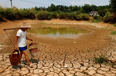
Climate Change Threatening China's Water Resources. The Chinese are taking climate change seriously - it's already having an impact on water supplies, as
reported by indiaexpress.com: "
Climate change is having an adverse impact on China’s water resources, said the country’s water resources minister. Chen Lei’s comments came during a meeting on climate change where he pointed out that global warming has become an important environmental issue, with water being one of the sectors most directly affected. "China faces an imbalance between the supply and demand of water to support its rapid social and economic development, while protecting the natural environment and ecosystems," the China Daily quoted Lei, as saying. "Global climate change could further exacerbate existing problems over water security, water supply and farming irrigation," Lei said. Lei also said China experiences a water shortage of 40 billion cubic meters a year, with two-thirds of cities facing increasing scarcity of water."


No comments:
Post a Comment