MCS: potential for a meso-convective system this morning, a large sprawl of strong/severe storms forming along the leading edge of an 80-degree warm front, moving southwest to northeast across the state. best chance: central MN.
80s likely later today - skies brighten later this morning with enough midday sun for low/mid 80s.
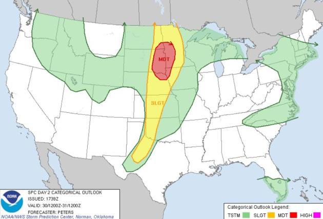
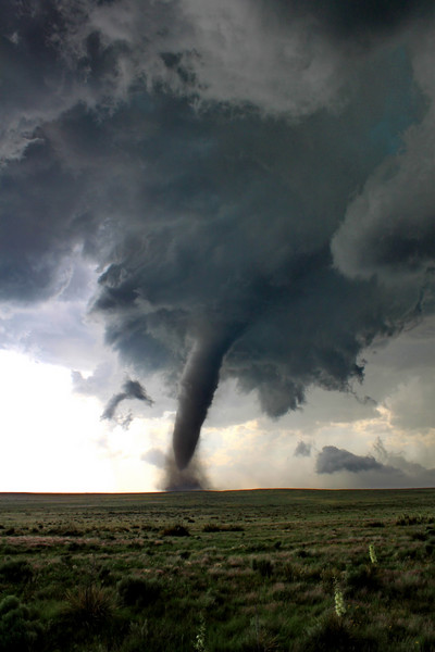
Moderate Risk: severe storms are likely again late this afternoon and evening. I expect a tornado watch for portions of Minnesota on Memorial Day, the greatest risk around the dinner hour, when the atmosphere will be most unstable. We can't rule out a few tornadoes in Minnesota later today.
90 possible by Friday in the metro area (mid 80s likely next weekend). It will finally feel like summer out there.
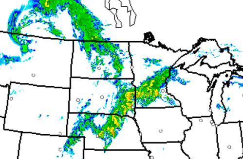
HRRR Rapid Refresh Model. One of NOAA's more reliable models is hinting at a few supercell thunderstorms over central Minnesota, near Little Falls or Brainerd, by 7-8 am this morning. I could envision a few severe storms early today, another (more widespread) risk of severe storms by late afternoon and evening. Map above is valid at 7 am this morning.
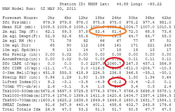
Ripe. We have many of the ingredients necessary for severe storms later today. According to the 00z NAM "cape" values (measure of instability) are forecast to be over 2,000, the lifted index (another stability index) is -5 (anything under 0 is potentially unstable). Highs should reach the mid 80s in the metro area - I suspect warm thermals will be able to break through the "cap" (an inversion a few thousand feet above the ground) - initiating strong/severe storms by late afternoon or evening, best chance western and central Minnesota.
1. Bill: "Why do you think so many people have been killed by tornadoes this year?"
A couple of reasons: twice as many tornadoes as usual, to date, and many large, violent, long-lasting tornadoes have been touching down east of the Mississippi, where population densities are much higher than traditional Tornado Alley. It’s the law of averages (mixed with a big dash of bad luck). If you have more tornadoes, and they’re touching down in population centers – the odds of injury and death are going to go up exponentially, in spite of Doppler radar, streamlined NWS warnings (which have been issued 20-40 minutes before these large tornadoes struck), media saturation, SKYWARN spotters and heightened awareness on the part of the public, the potential for disaster is rising – because of urbanization, and the fact that so many homes do not have basements, for a variety of reasons: bedrock, cost, groundwater, etc.
I suspect this spring’s extreme tornado season is the result of La Nina, coupled with a touch of climate change – although I don’t think we can pin everything on a warmer, wetter atmosphere. Water vapor has spiked by 4%. Tornadoes feed off of low-level moisture and wind shear. There’s no evidence that climate change is increasing wind shear, but a warmer atmosphere can hold more water (which is well documented). Something is injecting more energy into the system – I’ve never seen the jet stream blow this fast, or so far south in May, in my professional career. The jet should be blowing over the U.S./Canada border, instead it’s been dipping as far south as the Gulf coast – very odd.
2. Bill: "Does it say anything about the nature of and response to tornado warnings? Or about the way we run our lives these days, or the way we design our homes or cities?"
Hurricanes give us days to prepare, board up coastal homes and evacuate inland – they are slow-motion natural disasters. Same with floods, we can see them coming days, sometimes weeks in advance. Not so with tornadoes. We can tell when conditions are ripe, Sunday’s tornado watch in the Twin Cities preceded touchdown by over 2 hours. I think there is still a false sense of complacency among many people living in urban centers, a feeling that tornadoes can’t hit the close-in suburbs or downtowns, which is just plain wrong. We are also saturated with warnings (70% of tornado warnings are false alarms). Doppler picks up rotating thunderstorms that often go on to spin up tornadoes, but only 30% of these ever go on to spin up tornadoes. This breeds apathy (“they issue warnings, we never see anything at our place, let’s ignore the warning sirens”). That can lead to disaster.
A 2000 simulation in Dallas recreated what would happen if the May 3, 1999 Moore (EF-5) had gone through downtown Ft. Worth. They estimated a potential for 1,000-3,000 deaths with tens of thousands of injuries (as many as 80,000 local motorists might be stuck in the path of this monster tornado during gridlock on the freeways). It sent chills up my spine, reading the report. Statistically it’s only a matter of time before a major city is, in fact, struck by a large, violent tornado. To date America has been very, very lucky. But as cities expand, farmland continues to be developed, and our weather becomes more extreme over time, the potential for tornado disaster will continue to climb.
(photo courtesy of Weather Underground)
Bill "What’s your general reaction to the tremendous outbreak and toll, here and nationally?"
My reaction was one of scientific fascination mixed with utter horror. From the standpoint of being a meteorologist, this has been an unprecedented spring, unlike anything I have ever witnessed before. The 1974 “Super Outbreak” was the event that originally got me interested in meteorology. And the recent Alabama/Mississippi outbreak was even worse than ’74, which I thought I would never see again in my lifetime. This story tugs at your heart – seeing the interviews with parents searching for their kids, the not knowing…I can’t imagine what these people are going through.
I hope it’s a wake-up call for Minnesotans, a chance to review tornado drills with their kids. Like a fire drill, everyone should know exactly where to go in the event of a tornado. If you don’t have a basement consider spending 1-3k to reinforce a small interior room and turning it into a “safe room”. If you have a basement you’re generally ok. The sad reality: if an EF-4 or EF-5 hits your home and you don’t have a basement the odds of survival drop precariously. Residents of mobile homes should make sure there is an underground shelter they can get to with 1-2 minutes warning. People need to take tornado watches seriously. When watches are issued they should stay alert, keep an eye on the sky, always ask “where would I go, what would I do if a tornado approached at this location.
Situational awareness is key, so is having multiple safety nets. The more sources of tornado information, the better. That means:
- * Local media: radio, TV.
- * Internet (we will be trying some new ways to cover severe weather at startribune.com, by the way, shortly, maybe as soon as Monday).
- * NOAA Weather Radio (still the cheapest life insurance you can buy – the only thing that will wake you up at 2 am if a tornado is approaching).
- * Sirens (don’t rely on the sirens – they were never meant for indoor use).
- * Cell phone apps. This is the future. There are a handful of great apps that send out alerts when warnings are issued for your favorite locations or even your GPS location. One particularly good one that works well is My-Cast Weather Radar (full disclosure: it’s the company I sold to Garmin in 2007, but I’ve tried them all, this is still the best one out there – it even sends you an alert if lightning strikes within 5 miles of your location).
The scale number reflects a top three-second wind gust:
■ EF-0 65 mph to 85 mph: Peels surface off of some roofs, damages some gutters or siding, breaks branches off trees and knocks over shallow-rooted trees.
■ EF-1 86 mph to 110 mph: Roofs are severely stripped, mobile homes are flipped or badly damaged and windows and glass break.
■ EF-2 111 mph to 135 mph: Roofs are torn off well-constructed houses, foundations of frame houses move, and it destroys mobile homes, breaks large trees and lifts cars off the ground.
■ EF-3 136 mph to 165 mph: Well-constructed houses are destroyed, damage is severe to large buildings such as shopping centers, lifts heavy cars and carries away structures with weak foundations.
■ EF-4 166 mph to 200 mph: Levels houses, throws around cars.
■ EF-5 More than 200 mph: Well-constructed houses are carried away, cars are turned into missiles and even steel-reinforced concrete is badly damaged. High-rise buildings have their structures deformed.
* thanks to naplesnews.com for including this EF-scale in a larger story about storm threats for south Florida.
■ Watch for developing storms: Thunderstorms are most likely to develop on spring or summer days but can occur year-round. As the sun heats the air, pockets of warmer air start to rise and cumulus clouds form. Continued heating can cause these clouds to grow vertically into towering cumulus clouds, often the first sign of a developing thunderstorm.
■ When to seek safe shelter: Lightning can strike as far as 10 miles from the area where it is raining. That’s about the distance you can hear thunder. If you can hear thunder, you are within striking distance. Go to a large building or fully enclosed vehicle and wait 30 minutes after the last clap of thunder to go back outside.
■ Minimize the risk: Stop outdoor activities at the first roar of thunder to ensure everyone has time to get to a large building or enclosed vehicle. Leaders of outdoor events should have a written plan all staff are aware of and enforce.
■ Things to avoid: Stay off corded phones, computers and equipment that puts you in direct contact with electricity. Stay away from pools, indoor or outdoor, tubs, showers and other plumbing. Buy surge suppressors for key equipment. Install ground fault protectors on circuits near water or outdoors.
■ Helping a victim: If a person is struck by lightning, call 911 and get medical care immediately. Cardiac arrest and irregularities, burns and nerve damage are common in these cases. You are in no danger helping a victim. The charge will not affect you.
* Lightning information courtesy of naplesnews.com.
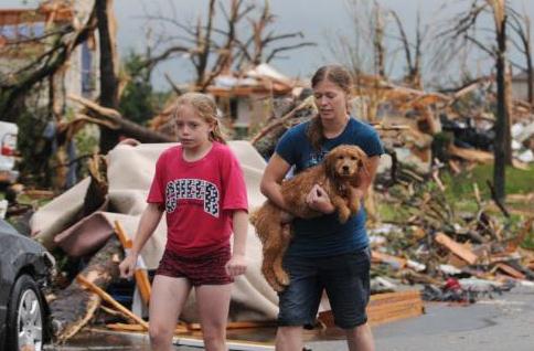
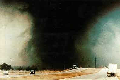
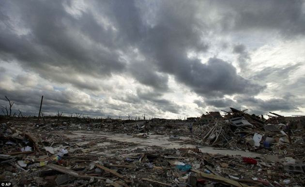
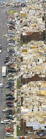
When Warnings Don't Work. The New York Times asks the question: with 25 minutes lead-time why did so many people die in Joplin? Why has the death toll been so high nationwide, in spite of Doppler radar, timely NWS warnings, and continuous media saturation? "TORNADO experts had seen it all before: whole neighborhoods obliterated, big-box stores flattened, even a hospital badly damaged. But what really shocked them about the powerful storm that struck Joplin, Mo., last week was the toll in lives: more than 125 and counting. “We thought we were done with the 100-dead tornadoes,” said Thomas P. Grazulis, a tornado historian in St. Johnsbury, Vt. “With warnings and Doppler radar, there was a lot of feeling that we were done with this stuff.” Experts are not sure yet why the toll was so high. Forecasts were made and warnings were issued, and this was an area, in the heart of Tornado Alley, where people knew what to do to protect themselves. “But something didn’t work the way we’d like it to,” said Harold Brooks , a research meteorologist with the National Severe Storms Laboratory in Norman, Okla. Experts say there will always be deaths when a strong tornado scores a direct hit on a heavily populated area. The question — for all disasters, not just twisters — has been how low casualty figures can go. “The fundamental characteristic of a major disaster is that there is going to be loss,” said Dr. Irwin Redlener, a professor at the Mailman School of Public Health at Columbia University and director of the National Center for Disaster Preparedness. “The goal of preparedness is to make that loss as minimal as possible, to optimize survival.”

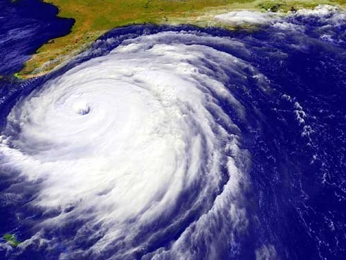
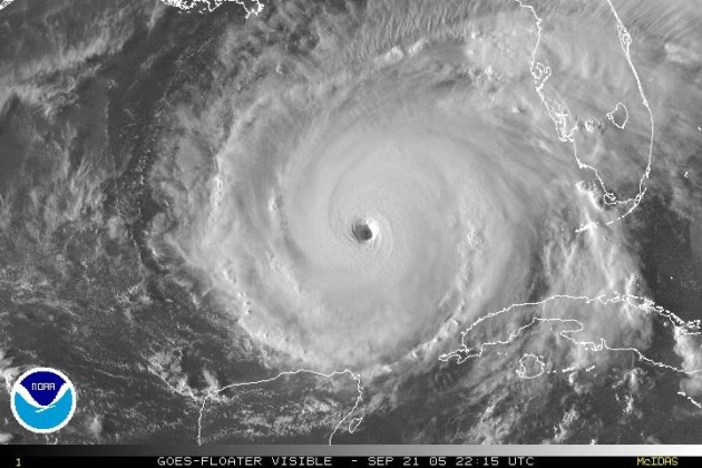
Don't Ignore Facts About Hurricanes. Jdnews.com has an update on what may be another above-average hurricane season for the USA: "Hurricane season is easy to ignore, especially when earthquakes, tsunamis, volcanic eruptions and tornadoes fill the news. And who wants to think of the worst possible scenario when the weather is finally so glorious? But ignoring the start of the hurricane season is like playing with matches — it’s a dangerous game that can lead to heartache. Instead, those who live in hurricane-vulnerable Eastern North Carolina need to be aware of the facts that surround the season: Fact: The National Oceanic and Atmospheric Administration says it’s anticipating a busier than average 2011 hurricane season. NOAA officials expect 12 to 18 named storms this year, with six to 10 hurricanes and three to six of those hurricanes turning into major storms. That’s a forecast worth monitoring."
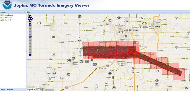
Joplin damage:
http://www.youtube.com/watch?v=VQZKWC3wTgU
http://www.youtube.com/watch?v=6ImhE-dP5I8
http://www.youtube.com/watch?v=uVzlMAlozKU
http://www.youtube.com/watch?v=HGnzgV4TXrk
http://www.youtube.com/watch?v=oAZq0XNQcGk
http://www.youtube.com/watch?v=1a0MXHTzCUA
http://www.youtube.com/watch?v=ZJTcYLeMmRg
MI funnel
http://www.youtube.com/watch?v=XJ6Jqiww1hE
MI flooding
http://www.youtube.com/watch?v=QFbKUbbTn0A&hd=1
SD damage/flooding
http://www.youtube.com/watch?v=f7j5Jo3ye3g&hd=1
OH flooding
http://www.youtube.com/watch?v=VA6BcoxR1b8&hd=1
* video clips courtesy of WeatherNation meteorologist Jason Parkin.http://www.youtube.com/watch?v=VQZKWC3wTgU
http://www.youtube.com/watch?v=6ImhE-dP5I8
http://www.youtube.com/watch?v=uVzlMAlozKU
http://www.youtube.com/watch?v=HGnzgV4TXrk
http://www.youtube.com/watch?v=oAZq0XNQcGk
http://www.youtube.com/watch?v=1a0MXHTzCUA
http://www.youtube.com/watch?v=ZJTcYLeMmRg
MI funnel
http://www.youtube.com/watch?v=XJ6Jqiww1hE
MI flooding
http://www.youtube.com/watch?v=QFbKUbbTn0A&hd=1
SD damage/flooding
http://www.youtube.com/watch?v=f7j5Jo3ye3g&hd=1
OH flooding
http://www.youtube.com/watch?v=VA6BcoxR1b8&hd=1


The Trouble With The Echo Chamber Online. I didn't even realize until recently that I was getting (personalized) Google search returns - what I see is different than what you see, for the same search request - based on my previous searches and preferences. Great. Personalization sounds great, but according to the New York Times there may be a downside: "ON the Web, we often see what we like, and like what we see. Whether we know it or not, the Internet creates personalized e-comfort zones for each one of us. Give a thumbs up to a movie on Netflix or a thumbs down to a song on Pandora, de-friend a bore on Facebook or search for just about anything on Google: all of these actions feed into algorithms that then try to predict what we want or don’t want online. And what’s wrong with that? Plenty, according to Eli Pariser, the author of “The Filter Bubble: What the Internet Is Hiding From You.” Personalization on the Web, he says, is becoming so pervasive that we may not even know what we’re missing: the views and voices that challenge our own thinking. “People love the idea of having their feelings affirmed,” Mr. Pariser told me earlier this month. “If you can provide that warm, comfortable sense without tipping your hand that your algorithm is pandering to people, then all the better.” Mr. Pariser, the board president of the progressive advocacy group MoveOn.org, recounted a recent experience he had on Facebook. He went out of his way to “friend” people with conservative politics. When he didn’t click on their updates as often as those of his like-minded contacts, he says, the system dropped the outliers from his news feed. Personalization, he argues, channels people into feedback loops, or “filter bubbles,” of their own predilections. Facebook did not respond to e-mails seeking comment."
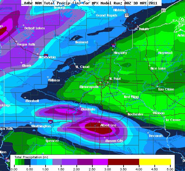
Potential For Gulley-Gushing Thunderstorms. The latest NAM model prints out some 1-2" rains for far western and southern Minnesota, as much as 3" near Albert Lea - lesser amounts in the Twin Cities.
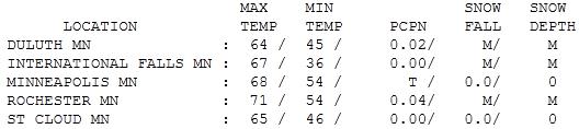
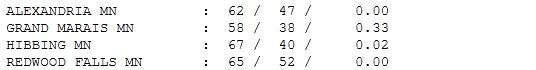
Gray Sunday. No, the sun wasn't out nearly as much as I had hoped. So much for "partly sunny" (which means the same thing as "mostly cloudy" by the way). No matter - it was pretty well "overcast" most of the day. At least it didn't rain, just a few spotty sprinkles. Highs ranged from 58 at Grand Marais to 65 at St. Cloud, 68 in the Twin Cities and a "balmy" 71 down at Rochester. All these readings were a good 10 degrees cooler than average - nothing new there.

Paul's SC Times Outlook for St. Cloud and all of central Minnesota:
MEMORIAL DAY: Strong/severe T-storms early. Enough midday sun for 80s by afternoon. Strong/severe storms develop by late afternoon/evening. I expect a tornado watch for portions of central Minnesota later today - stay alert. Winds: South 15-30. High: 82
MONDAY NIGHT: More T-storms, some severe early, locally heavy rain with a few of these storms. Low: 63
TUESDAY: Getting sunnier, turning breezy and less humid. High: 76
WEDNESDAY: Plenty of sun, no weather-drama. Low: 53. High: 74
THURSDAY: Warm frontal passage. More strong T-storms possible. Low: 60. High: 80
FRIDAY: New word: "hot". Isolated T-storm? Low: 65. High: 86
SATURDAY: Steamy and humid, scattered T-storms. Low: 68. High: 85
SUNDAY: Murky sun, few T-storms likely. Low: 66. High: 84
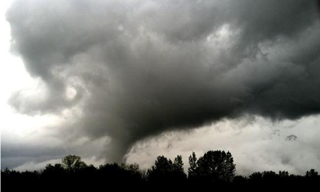
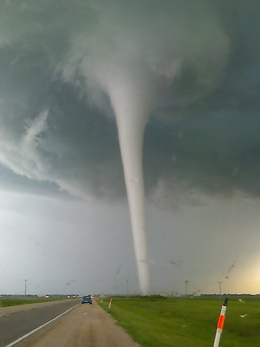
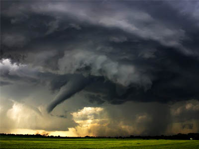
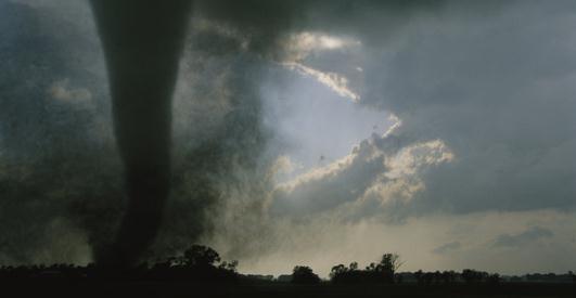
(May 21 tornado photo taken in Medina by Richard Sennott)
Warm & Thundery Memorial Day (significant severe threat)
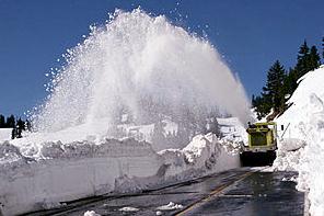
The reluctant spring of 2011 has been annoying, but I tell people the truth: our spell of cooler than normal days has inoculated us from the worst of the severe weather this spring. The battle-zone has stayed south, with a few notable exceptions. Record snow out west and freeze warnings up north, while the Deep South bakes under 90-degree heat. The result has been an energized, turbo-charged jet stream howling over the nation's heartland, creating a ripe environment for mutant, rotating "supercell" T-storms that often go on to spin up baseball-size hail and tornadoes.
Welcome to Tornado Nation; we've already seen a year's worth of twisters and the trends are ominous. Meteorologists call this "persistence", which is babble for "go with the flow - don't fight the trends." That's why I am worried about another unusually severe summer season for Minnesota.
Conditions are ripe for an MCS early today, a "meso-convective system", a swarm of heavy storms capable of frequent lightning & torrential rains. Skies brighten by midday, setting the stage for a few severe storms later. Be ready to move the party into the garage. A summerlike airmass arrives late week: 80s to near 90 anyone?

"In the foreword to a new book debunking scepticism of science - Climate Change Denial: Heads in the Sand - Oreskes argues that fear is the major driver of denial. ''Fear that our current way of life is unsustainable. Fear that addressing the issue will limit economic growth. Fear that if we accept government interventions in the market place … it will lead to a loss of personal freedom. Or maybe just plain old fear of change.''

No comments:
Post a Comment