Dry much of today, up through the dinner hour.
Heaviest rains: late tonight into Saturday morning, thunder possible.
Sunday: brighter, drier, warmer day of the weekend.
80 degree high possible Sunday afternoon, if the sun is out for a couple of hours (possible).
Strong T-storms: possible late Sunday afternoon, evening. Lifted indices fall to -4 with a predicted Cape of over 1,000. We can't rule out an isolated severe storm late Sunday, but most of the day should be dry, sticky and partly sunny.
* "Economic losses from natural disasters have soared from a global average of $25 billion annually during the 1980s to $130 billion a year during the decade ending in 2010." - Reuters story (below).
* "It's a new normal and I really do think that global weirding is the best way to describe what we're seeing," climate scientist Katharine Hayhoe of Texas Tech University told Reuters.

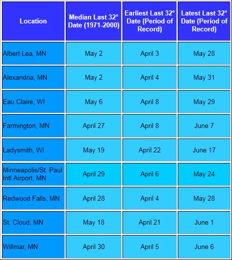
Freeze-Free? Yes, the frost and freeze season is (finally) behind us now. It's officially safe to plant those tender annuals. According to the local National Weather Service office: "Freezing temperatures after this point are uncommon across much of the area, but are still possible. The below table shows average and extreme last spring freezes for several communities around the area." No more f-words (frost and freeze - get your mind out of the gutter - until late September).
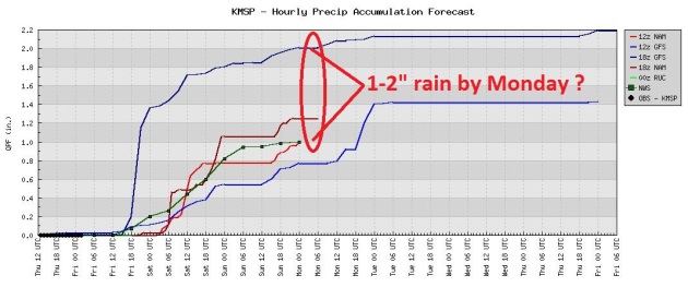
Potential For Some Gulley-Gushing Rains. Models diverge wildly with how much rain will fall from late Friday into Monday. The National Weather Service is predicting around 1" of rain by Sunday, the 18z GFS model Thursday was hinting at over 2" of rain by early next week. With convection (showery rains) it's impossible to pin down which towns will pick up the heaviest amounts of rain - but watering will probably be optional through the foreseeable future.
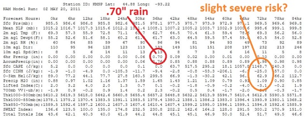
Analyzing The Numbers. The 00z Friday NAM model prints out .70" rain late tonight and Saturday morning - skies try to dry out (a bit) during the PM hours tomorrow. If there's any sun Sunday (and the mercury does approach 80 with dew points in the low 60s) there may be sufficient instability aloft for a few strong T-storms. A tiny percentage may even turn severe late Sunday.
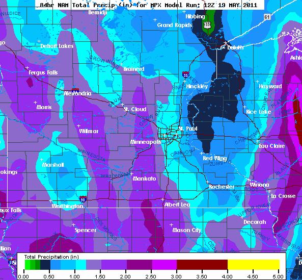
Big Variations. The latest NAM model prints out the heaviest amounts (over 1") over the western suburbs, less than a half inch east of St. Paul.
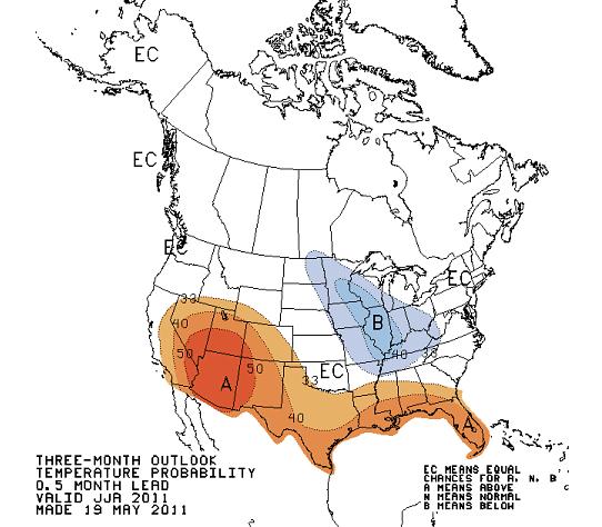
Summer Preview. CPC, the Climate Prediction Center, is still predicting a "cool bias" for much of the Midwest from June through August, the result of a southerly shift in the jet stream. Hotter than average readings are predicted for the south and southwest. I suspect we'll see fewer 90s than usual this summer - it will still get hot, but the odds of sustained, debilitating heat have diminished. Check out the data for yourself here.
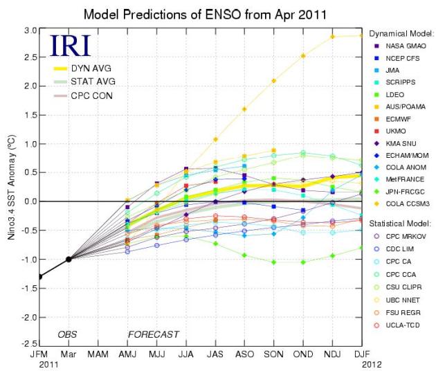
"ENSO-Neutral." Some good new: the La Nina cooling of the Pacific is forecast to weaken by June, the pattern transitioning into a weak El Nino later in 2011 - which MAY mean a (slight) bias toward milder than average weather next winter. Maybe that's wishful thinking, but El Nino events do correlate with milder winters in Minnesota. Let's not talk about winter for another 5 months, ok? The latest NOAA ENSO analysis is here.
"I'm white, born in Ohio to monolingual parents, and proud that I've learned to speak Spanish. Watching this video was made richer for me by being able to understand the Spanish, to the way the family members encouraged each other, shared their fear, and tried to help protect one another. They said the same things that most anyone in that situation would have said. I'm proud to live in a country that has allowed me my education: it's part of what makes me proud to be an American."
"I have been a television reporter and documentary filmmaker for 30-years and that is the bravest thing I have ever seen anyone do. The scariest video I have ever seen. So glad you all survived."
"That took a lot of guts to stand in a doorway with all that debris flying around. The two large pieces at 1:12 (middle left) could've caused serious injuries. Thank you for sharing!"
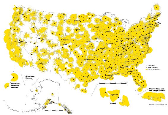
Coverage Map: NOAA Weather Radio (map above) covers most of the country with radio towers transmitting weather information without any commercials. NOAA Weather Radio transmitters are spread out throughout the country covering most populated areas with a sufficient broadcast signal. People at home or work can listen and stay informed especially when the weather gets ugly. Without a Weather Radio Alert, you may not get any warning at all leaving you with precious wasted time. By the time you become aware you are in a tornado, it may be too late."
* NOAA Weather Radios make GREAT birthday and anniversary gifts. Nothing says I Love You more than a radio that can (in theory and reality) save your life. And no, I don't get a spiff or commission. But I firmly believe that every home, every business, every school, nursing home and retail outlet should invest a whopping $30-50 and have one of these radios turned on, 24/7.
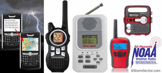
Tornado preparedness
• Have a plan for where your family will take shelter in case of a tornado warning. Storm cellars or basements provide the best protection. If underground shelter is not available, go into an interior room or hallway on the lowest floor possible. Stay away from windows, doors and outside walls. Go to the center of the room. Stay away from corners because they attract debris.
• Keep an emergency supply kit in your shelter location.
• If in a vehicle, trailer or mobile home, go quickly to a building with a strong foundation, if possible. If shelter is not available, lie flat in a ditch or other low-lying area. Do not get under an overpass or bridge.
• Have a plan for how your family will reach one another in case of an emergency, and in case phone service is not available.
• Inquire about emergency plans at places where your family spends time, like work, day care and school.
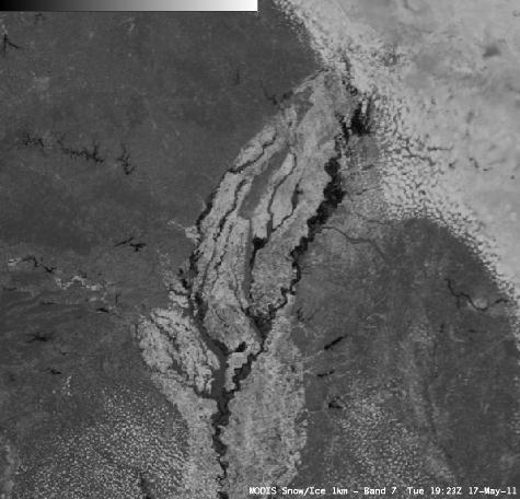
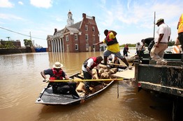
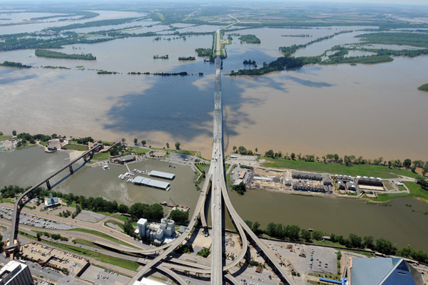
Flooding Continues Along The Mississippi River. The University of Wisconsin (CIMSS) weather blog has an update on how satellite technology is being tapped to track the Great Flood of '11: "AWIPS images of MODIS 0.65 µm visible channel data and MODIS 2.1 µm near-IR “snow/ice channel” data (above) demonstrated the utility of the snow/ice channel imagery for highlighting the areal extent of flooding along parts of the lower Mississippi River on 17 May 2011. Water is a strong absorber at the 2.1 µm wavelength, so it appears very dark on the MODIS snow/ice channel image. CIMSS participation in GOES-R Proving Ground activities includes making MODIS imagery available for National Weather Service forecasters to add to their AWIPS workstations. The VISIT training lesson “MODIS Products in AWIPS” is also available to help users understand the products and their applications to weather analysis and forecasting."
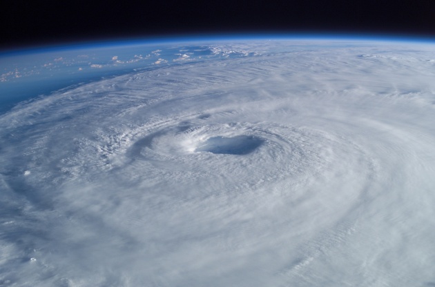
NOAA Hurricane Outlook: "an above-normal" Atlantic season. Click here for all the details.
- 12 to 18 named storms (winds of 39 mph or higher), of which:
- 6 to 10 could become hurricanes (winds of 74 mph or higher), including:
- 3 to 6 major hurricanes (Category 3, 4 or 5, winds of 111 mph or higher).
"Each of these ranges has a 70 percent likelihood, and indicate that activity will exceed the seasonal average of 11 named storms, six hurricanes and two major hurricanes.
“The United States was fortunate last year. Winds steered most of the season’s tropical storms and all hurricanes away from our coastlines,” said Jane Lubchenco, Ph.D., under secretary of commerce for oceans and atmosphere and NOAA administrator. “However we can’t count on luck to get us through this season. We need to be prepared, especially with this above-normal outlook.”
Climate factors considered for this outlook are:
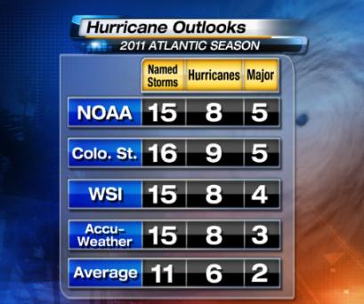
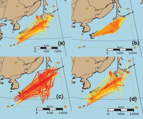
How Many Hurricanes? Here's a good summary of the hurricanes being predicted for the Atlantic basin (including the Gulf of Mexico and Caribbean) for 2011 from NOAA, Colorado State, WSI and AccuWeather. Thanks to Brian Alonzo and WeatherNation meteorologist D.J. Kayser for helping me track this down.
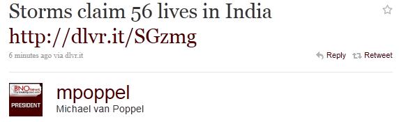 Storms Claim 65 Lives In India. Breaking News Network has the latest: "NEW DELHI (BNO NEWS) -- At least 56 people were killed when severe dust storms, accompanied by rain and thundershowers, lashed the Indian states of Uttar Pradesh and Bihar on Wednesday evening. The Times of India reported that at least 30 people were killed when a cyclonic storm hit several districts in the eastern state of Uttar Pradesh. Eight members of a marriage party were killed when a tree, uprooted by a fierce dust storm, fell on their jeep in Siddhartnagar district, according to Press Trust of India."
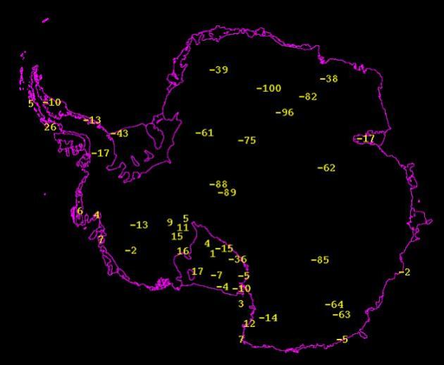
A Cool -100 F. In The Shade. I guess I won't complain about a little patchy frost earlier this week. Here's the latest from the University of Wisconsin: "Earlier today, at 7 UTC (2am CDT), an AWS in eastern Antarctica reached a temperature of -100F! This station is JASE2007 and is owned by both the University of Wisconsin and Japan. This is the first time in 2011 that the temperature has fallen to -100F! Below is a plot of the observed AWS temperatures at 7 UTC."
• Keep an emergency supply kit in your shelter location.
• If in a vehicle, trailer or mobile home, go quickly to a building with a strong foundation, if possible. If shelter is not available, lie flat in a ditch or other low-lying area. Do not get under an overpass or bridge.
• Have a plan for how your family will reach one another in case of an emergency, and in case phone service is not available.
• Inquire about emergency plans at places where your family spends time, like work, day care and school.
Flooding Continues Along The Mississippi River. The University of Wisconsin (CIMSS) weather blog has an update on how satellite technology is being tapped to track the Great Flood of '11: "AWIPS images of MODIS 0.65 µm visible channel data and MODIS 2.1 µm near-IR “snow/ice channel” data (above) demonstrated the utility of the snow/ice channel imagery for highlighting the areal extent of flooding along parts of the lower Mississippi River on 17 May 2011. Water is a strong absorber at the 2.1 µm wavelength, so it appears very dark on the MODIS snow/ice channel image. CIMSS participation in GOES-R Proving Ground activities includes making MODIS imagery available for National Weather Service forecasters to add to their AWIPS workstations. The VISIT training lesson “MODIS Products in AWIPS” is also available to help users understand the products and their applications to weather analysis and forecasting."
NOAA Hurricane Outlook: "an above-normal" Atlantic season. Click here for all the details.
- 12 to 18 named storms (winds of 39 mph or higher), of which:
- 6 to 10 could become hurricanes (winds of 74 mph or higher), including:
- 3 to 6 major hurricanes (Category 3, 4 or 5, winds of 111 mph or higher).
"Each of these ranges has a 70 percent likelihood, and indicate that activity will exceed the seasonal average of 11 named storms, six hurricanes and two major hurricanes.
“The United States was fortunate last year. Winds steered most of the season’s tropical storms and all hurricanes away from our coastlines,” said Jane Lubchenco, Ph.D., under secretary of commerce for oceans and atmosphere and NOAA administrator. “However we can’t count on luck to get us through this season. We need to be prepared, especially with this above-normal outlook.”
Climate factors considered for this outlook are:
- The continuing high activity era. Since 1995, the tropical multi-decadal signal has brought ocean and atmospheric conditions conducive for development in sync, leading to more active Atlantic hurricane seasons.
- Warm Atlantic Ocean water. Sea surface temperatures where storms often develop and move across the Atlantic are up to two degrees Fahrenheit warmer-than-average.
- La Niña, which continues to weaken in the equatorial Pacific Ocean, is expected to dissipate later this month or in June, but its impacts such as reduced wind shear are expected to continue into the hurricane season."
How Many Hurricanes? Here's a good summary of the hurricanes being predicted for the Atlantic basin (including the Gulf of Mexico and Caribbean) for 2011 from NOAA, Colorado State, WSI and AccuWeather. Thanks to Brian Alonzo and WeatherNation meteorologist D.J. Kayser for helping me track this down.
A Cool -100 F. In The Shade. I guess I won't complain about a little patchy frost earlier this week. Here's the latest from the University of Wisconsin: "Earlier today, at 7 UTC (2am CDT), an AWS in eastern Antarctica reached a temperature of -100F! This station is JASE2007 and is owned by both the University of Wisconsin and Japan. This is the first time in 2011 that the temperature has fallen to -100F! Below is a plot of the observed AWS temperatures at 7 UTC."
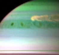
Super Storm on Saturday. NASA's Science News has the story: "May 19, 2011: NASA's Cassini spacecraft and a European Southern Observatory ground-based telescope are tracking the growth of a giant early-spring storm in Saturn's northern hemisphere so powerful that it stretches around the entire planet. The rare storm has been wreaking havoc for months and shooting plumes of gas high into the planet's atmosphere. (The false-color infrared image above shows clouds of large ammonia ice particles dredged up by the powerful storm. Credit: Cassini. [more]) "Nothing on Earth comes close to this powerful storm," says Leigh Fletcher, a Cassini team scientist at the University of Oxford in the United Kingdom, and lead author of a study that appeared in this week's edition of Science Magazine. "A storm like this is rare. This is only the sixth one to be recorded since 1876, and the last was way back in 1990." Cassini's radio and plasma wave science instrument first detected the large disturbance in December 2010, and amateur astronomers have been watching it ever since through backyard telescopes. As it rapidly expanded, the storm's core developed into a giant, powerful thunderstorm, producing a 3,000-mile-wide (5,000-kilometer-wide) dark vortex possibly similar to Jupiter's Great Red Spot."
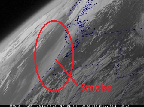
Smoke From Alberta Fires Spreading Into Pacific Northwest. Sunsets in the coming weeks may be a bit redder and richer than usual, thanks to fires burning out of control across Alberta, Canada. The University of Wisconsin CIMSS blog has the details: "McIDAS images of GOES-13 0.63 µm visible channel data (above) revealed a hazy plume moving southward along the Pacific Northwest coast of the US on 18 May 2011. The airborne smoke showed up very well due to a favorable “forward scattering angle” later in the day, as viewed from GOES-13 (GOES East) located at 75º West longitude. It is very likely that this hazy plume was due to long range transport of smoke from recent fire activity in northern Alberta, Canada — large smoke plumes were seen over that region on GOES-11 and GOES-13 visible channel images as early as 15 May. NOAA ARL HYSPLIT model backward trajectories initialized at altitudes of 6 km, 7 km, and 8km (below) did indeed indicate transport from the region of the fires. Lidar data from the University of British Columbia showed that the portion of the aerosol layer over Vancouver was located at altitudes of 7-8 km."
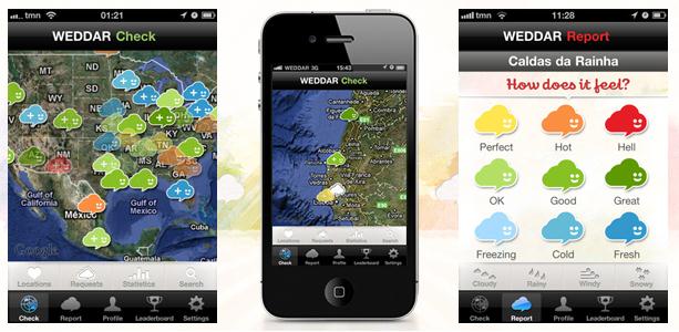
Crowd-Sourced Weather App Provides Real-Time Updates. Springwise.com has a story about a new (and intriguing) weather app available at the iTunes store: "Despite advances in meteorological technology, and the ever increasing accuracy of weather predictions, there is still a degree of uncertainly that comes with any forecast. The new app Weddar hopes to solve this problem through the power of crowdsourcing. The app can be used to both submit and browse for local weather reports. For example, a user in the suburbs wondering what the weather is like in the center of town can send a request to Weddar to find out. Weddar will then alert other users in the town center who can upload a report on the the type of weather they are experiencing, as well as stating how they rate the temperature — as “perfect”, “hot”, “fresh”, or "freezing", for example. Users can also upload reports unprompted by Weddar whenever they feel so inclined, with all the reports being placed on the Weddar map using the smartphone’s geolocator. Whenever an entry is submitted, reporters gain points and are allocated a respective rank on the leader board. Users can also set to have their reports shared automatically as status updates on Facebook or on Twitter. The reports, meanwhile, fade on the map over time, to ensure that those made many hours before the map is checked do not mislead. The app is currently available from the App store. Weddar enables highly localised weather reporting, and also gives users the subjective views of those making the reports. In the words of Ricardo Fonseca, the app’s co-founder, “With the old weather report services you get the usual, broad and generalist “New York, 93º f, 73% humidity, NE light wind” reports. In Weddar, someone, somewhere in Central Park will tell you that the weather “Feels perfect.”, another one near the river will tell you that “Feels good but windy”, because weather conditions really are different in a same city.” Makes sense to us!"


iPhone
* "You can magnify the iPhone’s screen, for ease in reading tiny type, by double-tapping with three fingers. Then pan around by dragging with three fingers.
* Of course, you first have to turn this feature on. Do that by tapping Settings, then General, then Accessibility. (On the same screen, you’ll find an option to make the text bigger in the built-in iPhone programs, which is handy in its own way.)
* Has your iPhone screen image suddenly become mysteriously enlarged? There’s nothing quite as alarming as seeing jumbo text and graphics, and nothing restores the phone to the way it’s supposed to be.
* I can’t tell you how many people trek off to the Apple Store to get their “broken” iPhones fixed. Of course, the real problem is that you’ve accidentally turned on screen zooming (described in the previous tip). Double-tap with three fingers to restore the screen magnification."


A Brief History of Zombies
We’ve all seen at least one movie about flesh-eating zombies taking over (my personal favorite is Resident Evil
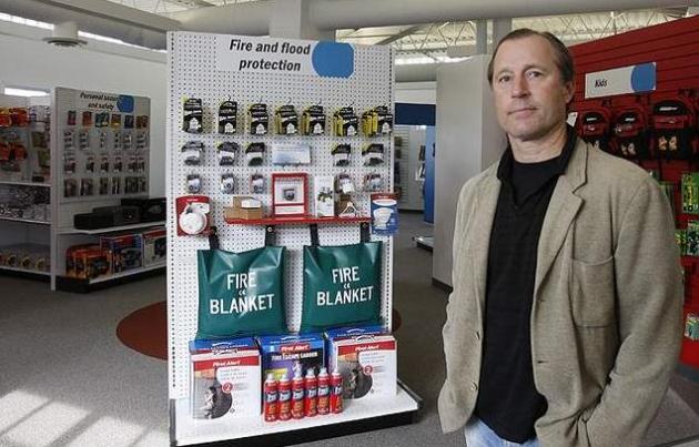
Better Safe than Sorry

Some of the supplies for your emergency kit.
- Water (1 gallon per person per day)
- Food (stock up on non-perishable items that you eat regularly)
- Medications (this includes prescription and non-prescription meds)
- Tools and Supplies (utility knife, duct tape, battery powered radio, etc.)
- Sanitation and Hygiene (household bleach, soap, towels, etc.)
- Clothing and Bedding (a change of clothes for each family member and blankets)
- Important documents (copies of your driver’s license, passport, and birth certificate to name a few)
- First Aid supplies (although you’re a goner if a zombie bites you, you can use these supplies to treat basic cuts and lacerations that you might get during a tornado or hurricane)

Zombies Ate My Research Assistant. Now this all makes sense. All those climate scientists conspiring to point a finger of blame at (living) people for anthropogenic climate change are really zombies. That explains a lot. Not sure, but I think this post may be subtle sarcasm, brought to you by Patrick Lockerby, the Chatter Box, and science20.com: "Zombies are the product of communist tampering with forbidden science. The FACT that most climate "scientists" are zombies also explains why so many skeptics are afraid to speak out. It takes a very brave person to make bold claims over and over again in the face of stubborn resistance to TRUTH. That's why so many people post skeptic comments as anonymous or abc123 or Dr. [insert name] Phd. People who use their real names to post their well-founded scientific objections to paying a tax on pollution risk being torn to pieces and eaten alive."
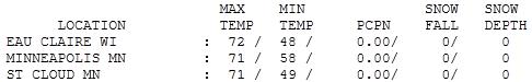
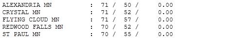
Cloud-Cluttered. Thursday wasn't too bad, but clouds were on the increase during the day, keeping us a couple degrees cooler than we would have been otherwise. The sun stayed out much of the day over the northern half of Minnesota. Highs ranged from 70 at St. Paul to 71 in St. Cloud to 72 at Eau Claire, WI.
Paul's SC Times Outlook for St. Cloud and all of central Minnesota:
TODAY: Warm, PM showers, T-storms. Winds: SE 10-20. High: 72
FRIDAY NIGHT: Showers and storms, locally heavy rain possible. Low: 55
SATURDAY: Showers, storms likely, especially morning/midday hours. A brighter PM? Peeks of sun possible by late afternoon and evening. Winds: SE 10-20. High: 73
SATURDAY NIGHT: Partly to mostly cloudy and sticky. Low: 60
SUNDAY: Some sun morning/midday hours. Mostly PM showers, T-storms. Winds: S 10-15. High: 78
MONDAY: Showers linger, cooler - still damp. Low: 57. High: 68
TUESDAY: Intervals of sun, a cooler, drier day. Low: 50. High: 63
WEDNESDAY: Partly sunny & pleasant. Low: 49. High: 66
THURSDAY: More clouds, passing sprinkle? Low: 51. High: 68
The "New Normal"?
Historic tornado outbreaks in the south, "epic flooding" on the Mississippi. An "exceptional drought" in Texas & Louisiana. Record snowfall out west. What is going on? Is this one great big cosmic coincidence - or is it possible to connect the dots? In a recent Reuters story Allstate CEO Thomas Wilson said: "There is a lot more severe weather. We are running our homeowners business as if this is a permanent change as opposed to an anomaly." In the 80s economic losses from weather-related disasters cost $25 billion annually. Since 2000 the damage toll has spiked to $130 billion every year. "It's a new normal and I really do think that global weirding is the best way to describe what we're seeing," climate scientist Katharine Hayhoe of Texas Tech University told Reuters. No, you're not imagining it. Welcome to the new normal.
The weekend is at hand and right on schedule: here come the showers and T-storms! The severe risk should pass just south of Minnesota this weekend, but we may pick up nearly 1" rain by Sunday night. The best chance of tripping over puddles: tonight through midday Saturday, more pop-up instability showers & T-storms Sunday afternoon. No snow. Thank God.

The Myth of "Energy Security." Slate.com has the rather provocative story. Theory or fact? Yes, energy security may be an oxymoron right up there with "airline food", "jumbo shrimp" and "Senate Intelligence Committee": "Turmoil across the Middle East and Northern Africa has refocused attention on the impact that political tensions or interference can have on the price and availability of energy imports. Partly because of consumer fears of gas-price hikes, energy security ranks high on many Western governments' policy agenda. Of course, this is hardly a new phenomenon: Europe started trying to build up its energy reserves back in the 1960s. Likewise, every American president since Richard Nixon in the early 1970s has tried, and failed, to reduce dependence on foreign oil. A new trend, though, is that policies that just a few years ago were being touted to fight climate change are being presented as a necessary way to increase energy security. Against the backdrop of the financial crisis, and as public support for climate-change policies scrapes new lows in many developed countries, we hear less from leaders about the threat of global warming, and more about the supposed economic benefits of climate policies. This shift is hardly surprising, given the increasing number of analyses that demonstrate that current—unilateral—climate policies will have virtually no impact on the rise in global temperature."

Skeptic Argument: Antarctic Is Gaining Ice debunked by Angela Flanagan
Skeptic Argument: Oceans are Cooling debunked by Ryan Maloney
Skeptic Argument: Hurricanes are not Linked to Global Warming debunked by Nick Panico
Skeptic Argument: IPCC is Alarmist debunked by Jason Quilty
Note: Each of the students above gave the (Skeptical Science blog) permission to post their papers and names on this blog. Thanks to Scott Mandia for passing these along.


No comments:
Post a Comment