73 F. predicted high today. A very nice day is expected over the northern half of Minnesota. Expect a mix of clouds and sun across central Minnesota, a slight chance of a PM shower or T-shower over far southern Minnesota (best chance close to the Iowa border). Winds: SE 10-15. Slowing falling barometer.
Low 80s likely from Thursday into the weekend.
Heaviest showers/T-storms expected over western MInnesota this week.
Severe Threat: should stay just south/west of Minnesota through midweek.
"Risk modeling firm AIR Worldwide forecast that the twisters and thunderstorms will cost insurers $4 billion to $7 billion." - Star Tribune article (below) on massive insurance losses due to tornadoes & severe storms.

"Keep in mind that hurricanes or storms are travelling at about six to 12 knots and today's modern ship cruises over 20 knots," he says. - article on cruising during hurricane season in the Vancouver Sun (below).
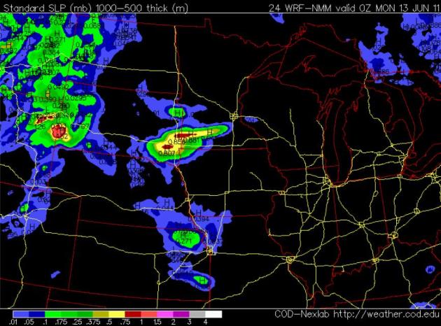
Synoptic Map. A weak bubble of high pressure centered over the Great Lakes should hang on long enough for intervals of sun much of today, although clouds will be on the increase over western counties of Minnesota. A very slow-moving front over the Dakotas will push a few showers and T-storms into southwestern Minnesota later today - nothing severe expected.
Sunday Showers Southwest. The northern half of Minnesota should experience a pretty nice Sunday, enough sun for highs in the low 70s. A weak warm frontal boundary entering far western Minnesota may spark a few PM showers and T-storms, best chance south/west of the Minnesota River. Most of the day should be dry in the metro, but we can't rule out a sprinkle or light shower by evening.
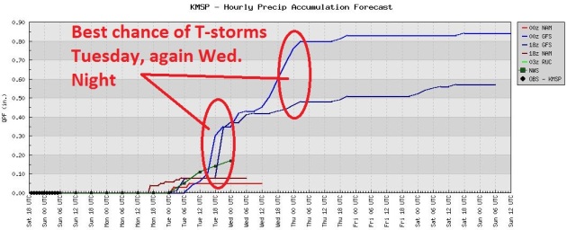
Growing Thunder Threat. A stray T-shower is possible Monday; the chance of showers and T-storms increases Tuesday and Wednesday, with the heaviest rains falling over far western Minnesota.
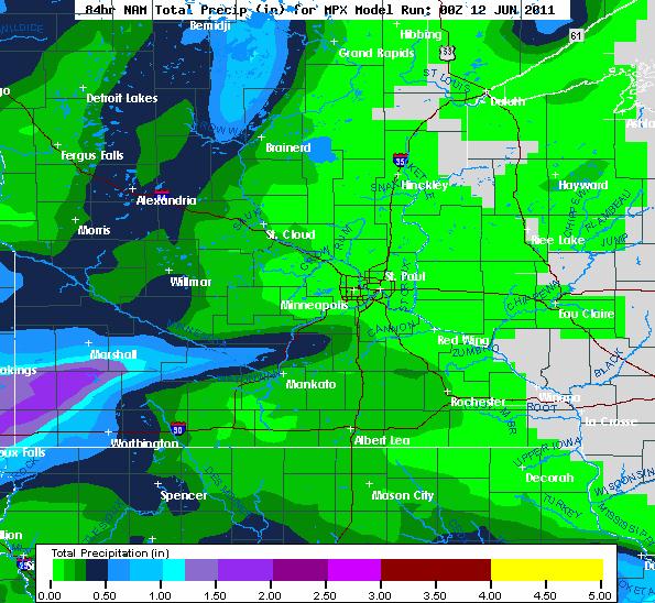
Growing Risk Of A Free Lawn-Watering. The 84 hour NAM prediction shows the heaviest rains (over 1.5") falling over far southwestern Minnesota, near Marshall and Pipestone; under .20" expected in the Twin Cities metro area and St. Cloud.
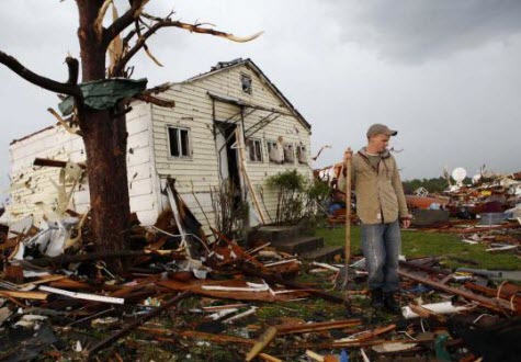
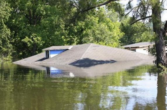
Rare Infection Strikes Victims of Joplin Tornado. Could it get any worse for those people? Good grief - as if they haven't already been through enough. The New York Times reports on a Mucormycosis fungal infection, extremely rare, and often lethal. As many as 5-10 additional deaths in Joplin have been blamed on this infection: "Several people who were injured when a tornado devastated Joplin, Mo., last month have become sickened by an uncommon, deadly fungal infection and at least three have died, although public health officials said Friday that a link between the infection and the deaths was not certain. Also on Friday, the death toll from the tornado was raised to 151. Eight tornado victims have fallen ill from the mysterious infection, and each had “multiple injuries and secondary wound infections,” said Jacqueline Lapine, a spokeswoman for the Missouri Department of Health and Senior Services. Citing confidentiality rules, officials declined to discuss the treatment or condition of the patients. The fungus that causes the infection, which is believed to be mucormycosis, is most commonly found in soil and wood, according to the Centers for Disease Control and Prevention, which is studying samples from the eight Joplin patients. “It is a very aggressive and severe infection,” said Dr. Benjamin Park, chief of the epidemiology team in the C.D.C.’s Mycotic Diseases Branch. “It is also very rare.” (photo above courtesy of the Boston Globe).
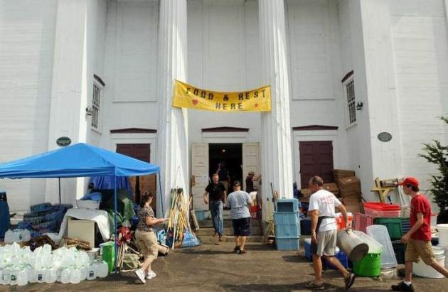
Reaching Out, Coping After Storm. Here's a story from the Worcester Telegram & Gazette focused on the importance of faith after a major storm, like the series of tornadoes that slammed into central Massachusetts recently: "There is one rule within the walls of the First Congregational Church in Brimfield: “No destruction is spoken here.” “If they want to talk to about it, that's different. But you are not to ask someone, what happened to you?” said Ms. Lynch. “Our volunteers are told, you don't ask people their story,” said Gina Lynch, director of the Senior Center and the church's fellowship and outreach committee. “If they want to talk to about it, that's different. But you are not to ask someone, what happened to you?” said Ms. Lynch. “The coolest thing about this place, you walk in this door. You never know who's a volunteer, who's a victim. We designed it this way. We want the victims to be able to come and rest.” A lot of people coming into the church have lost their homes and the last thing they want to do is to relive the horror, said Ms. Lynch. “It's like when you have been in a car accident or had a death in the family. You don't want to keep telling that story over and over, because every time you do, you're reliving the story,” Ms. Lynch said. “So we want this to be a place where they can come and laugh and have fun and just be themselves.”
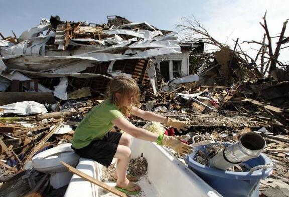
Tornadoes Pummel Travelers, Other Property Insurers. The Star Tribune has the latest on Travelers Company, which has a large operation in St. Paul - hit very hard by tornado claims this spring: "Travelers Cos. Inc. said Friday that it will pay at least $1 billion in insurance claims and suffer a second-quarter operating loss from tornadoes and hailstorms that pummeled 13 midwestern and southern states in April and May. The insurance giant's stock fell $1.87 to $59.21 a share Friday as stunned investors responded to the news. The slide contributed to the woes of the Dow Jones industrial average, which fell below 12,000. Allstate Corp. reported similar catastrophe losses. The two property insurers set the tone for what is expected to be a brutal year for the property insurance industry -- the worst since 2005 when Hurricane Katrina struck the Gulf Coast. Travelers, based in New York with key operations in Hartford, Conn., and St. Paul, said spring storms damaged businesses and residential property. An unprecedented number of twisters rained terror and destruction on Joplin, Mo., north Minneapolis, Kansas, Alabama and other places. The insurance industry reported more than 1,400 tornadoes for the first five months of 2011. The storms caused 515 deaths and billions of dollars in insured property damage. Risk modeling firm AIR Worldwide forecast that the twisters and thunderstorms will cost insurers $4 billion to $7 billion."
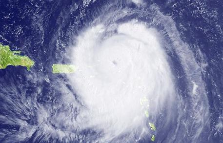
Cruising Through Hurricane Season. You can often book a (much) better rate for cruises during the height of hurricane season: September and early October, when water temperatures generally peak. But if you have your heart set on a specific destination, a specific shore excursion, you might want to time your cruise for late fall or winter and avoid the risk of a detour, according to The Vancouver Sun: "The Atlantic hurricane season is officially underway and it will have a six-month run. Words like "hurricanes" and "tornadoes" always sound ominous, especially right now and, for cruisers, especially "hurricanes." Every year, these Atlantic storms have their genesis in Africa and they either die or start to build as they make their way west across the ocean. Every year -right about now -I start to get e-mails from people asking if it's safe to book a cruise during hurricane season. The short answer is yes, with the caveat that you must be prepared for possible changes in your routing. The NOAA (National Oceanic and Atmospheric Administration) is the main source for hurricane information and, with its hurricane centre in south Florida, is the ideal supplier of information to cruise lines. Last week, NOAA announced its predictions for this year's hurricane season. The prognosis is there will be 12 to 18 named storms, of which six to 10 will become hurricanes and three to six will become major hurricanes. That's consistent with what other forecasters are saying."

Cleaning Up Your Online Reputation Can Be Costly. One defamatory information, rumor or innuendo gets out onto the Wild Wild Web - it's hard to put the genie back into the bottle, tough to put the toothpaste back into the tube. That said, with enough $$ there are firms that are more than willing to (try) to help make it harder for consumers to find negative reviews or that unfortunate photo of you on your last vacation. The New York Times has the story: "THE Web is like an elephant — it never forgets, and if let loose it can cause a lot of trouble. I couldn’t help being reminded of this when I heard about the women who had received Representative Anthony Weiner’s lewd photos. Even though the women appear to have done nothing wrong, their names are likely to be forever linked to Mr. Weiner in an online search. Most people do not generate enough positive mentions to push the negative ones lower in search engine rankings. “These are people who are collaterally damaged,” said Michael Fertik, chief executive and founder of Reputation.com, which helps people control their online identities. “The blogosphere is interested in you, but three days later it’s over and you’re forgotten forever. But you’re branded as that person.” This would not have been the case a decade or two ago, when most embarrassing incidents simply died away. Or if they did not, people could simply move elsewhere and reinvent themselves. The Web has changed that."
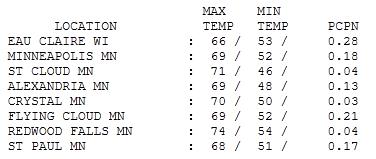
A Fine Saturday. Showers Friday night dropped anywhere from .04" at St. Cloud and Redwood Falls to .28" at Eau Claire, .18" fell on the Twin Cities. Daytime highs yesterday ranged from 66 at Eau Claire to 69 in the Twin Cities and Alexandria, 71 at St. Cloud and 74 at Redwood Falls.
Paul's SC Times Outlook for St. Cloud and all of central Minnesota:
TODAY: Plenty of sun, breezy and mild. Winds: SE 10-15. High: 73
SUNDAY NIGHT: Partly cloudy. Low: 56
MONDAY: More clouds, T-storm late? High: 74
TUESDAY: Humid, more numerous T-storms. Low: 58. High: 76
WEDNESDAY: Front stalls, scattered storms. Low: 61. High: 79
THURSDAY: A bit drier, still warm. Low: 62. High: 81
FRIDAY: Clouds increase, late rain - few T-storms possible. Low: 63. High: 81
SATURDAY: Hazy sun, a few PM storms. Low: 62. High: 82
La Nina: RIP
It's official. According to NOAA, the La Nina cooling of equatorial Pacific Ocean water is over. "Collectively, these oceanic and atmospheric anomalies reflect a transition to ENSO-neutral conditions, but with lingering La Nina-like atmospheric impacts, particularly in the global Tropics," NOAA proclaimed last week. Uh oh. El Nino? It's weak, but if (and it's a big if) the Pacific warms up a few more degrees we may slide into an El Nino pattern, which correlates with milder winters for Minnesota.
Here's what puzzles me: if La Nina is "adios", then why are we seeing such spectacular weather extremes across the USA? Ski resorts are still open in the Rockies (in June!), while much of the south and east is baking under 100-degree heat. The Missouri River is forecast to remain above flood stage through September, an "exceptional" drought is cooking a broad stretch of dusty land from Georgia to New Mexico, tornadoes still touching down in very unlikely places. Is this all a fluke, or the "new normal"? Time will tell.
The sun stays out today, low 70s with a southeast breeze. 80s return the latter half of the week, a growing chance of T-storms spilling over into next weekend.
Is All The Wild Weather Connected? I'm hearing this question (a lot). I'm all for coincidence and serendipity, but this spring has probably set a record for, well, the number of records! Every day something (bad) is flaring up somewhere, from massive wildfires in Arizona (half the size of Rhode Island), record snowfall out west, "exceptional" drought in the south and southwest, record floods on the Mississippi and Missouri, record tornadoes, and now (record) heat is building across much of America. As I told you yesterday La Nina is gone, the Pacific has warmed back up to normal levels, so we can't just point a finger of blame at La Nina. What's left? Normal atmospheric variability? The weather has always been extreme, but this is about the frequency and intensity of extreme events. Is it the media? With social media we're getting more reports (instantly) from the scene. This may be a factor, but I still suspect something else is going on, something else is supersizing our storms, floods and droughts. Here's one theory from Live Science: "The impact of La Niña is also to generate wet Ohio Valley conditions in late winter," Hoerling told Life's Little Mysteries, a sister site to LiveScience. This year, however, the rains were heavier than in any prior year, La-Niña-year or otherwise. "The extreme nature of these rains is beyond what can be reconciled with La Niña alone." Most NOAA researchers believe the extreme flooding is partially a result of climate change induced by global warming. "The flooding and the heavy rainfall are consistent with what we expect with global warming," said David Easterling, chief of the Global Climate Applications Division at NOAA's National Climatic Data Center. "Looking at some of the modern trends, we've seen increases in the amount of water vapor in the atmosphere, drawing a direct link between what's happening in the Midwest and global warming." On top of global warming and La Niña, natural weather variability is undeniably playing a role, just as it does every year. "Natural atmospheric variability almost certainly contributed significantly to these extreme events," Hoerling wrote in an email. There have always been droughts and floods, and while global warming and La Niña may have helped them along this year, they may have hit hard regardless.
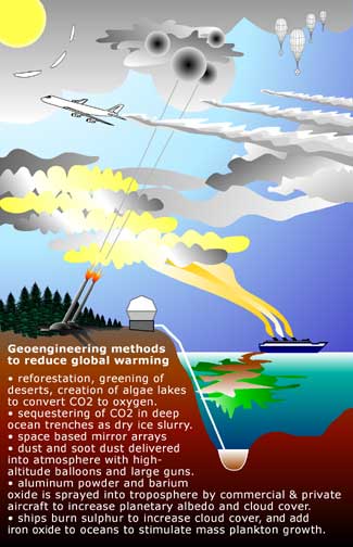
Geo-Engineering Can Help Save The Planet. I'm skeptical, but keeping an open mind that a garage full of smart eco-engineers can create technology that will vacuum excess CO2 and methane out of the atmosphere. Never say never. We need a few (revolutionary) breakthroughs in energy production and carbon sequestration. Hopefully these innovations will originate in the USA. The New York Times has a story focused on geo-engineering: "Carbon dioxide levels in the atmosphere are pushing 400 parts per million (p.p.m.) — up from the natural pre-industrial level of 280 p.p.m. Emissions for last year were the highest ever. Rather than drift along until a calamity galvanizes the world, and especially the United States, into precipitous action, the time to act is now. The biology of the planet indicates we are already in a danger zone. The goal of limiting temperature increase to 2 degrees Celsius, as discussed at the Copenhagen and Cancun climate summits, is actually disastrous. As we push the planet’s average temperature increase beyond 0.75°C, coral reefs (upon which 5 percent of humanity depends) are in increasing trouble. The balance of the coniferous forests of western North America has been tipped in favor of wood-boring bark beetles; in many places 70 percent of the trees are dead. The Amazon — which suffered the two greatest droughts in recorded history in 2005 and 2010 — teeters close to tipping into dieback, in which the southern and eastern parts of the forest die and turn into savannah vegetation. Estimates of sea-level rise continue to climb. Even more disturbing, scientists have determined that, if we want to stop at a 2°C increase, global emissions have to peak in 2016. That seems impossible given current trends. Yet most people seem oblivious to the danger because of the lag time between reaching a greenhouse gas concentration level and the heat increase it will cause. So what to do? One possibility is “geo-engineering” that essentially takes an engineering approach to the planet’s climate."
No comments:
Post a Comment