78 F. normal high for June 13.
.44" rain predicted betwen now and Thursday for the St. Cloud area (NAM model) - best chance of showers & a few T-storms comes late tonight into Wednesday.
78-82 F: predicted high in the St. Cloud metro area from Friday through Sunday.
Weather Summary. A weak ridge of high pressure holds on one more day, meaning intervals of sun, highs in the 70s, and a few scattered showers and T-storms, mainly over western Minnesota. Right now it appears that the best chance of a few hours of showers and storms will come late tonight into Wednesday. We dry out (temporarily) behind a weak trough of low pressure Thursday, but scattered T-storms return as early as Friday, spilling over into part of the weekend. Right now it doesn't look like a steady weekend rain, but a warm front lurking nearby will spark scattered T-storms. At least next weekend will be warmer, highs ranging from upper 70s (north) to low 80s (south) - a little better for the lake, but still not perfect. We're still searching for "perfect".
Weekend Preview:
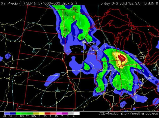
Saturday: Partly-Thundery. The GFS (guestimate) valid 1 pm Saturday afternoon (showing accumulated rain the previous 6 hours) hints that the most widespread showers and T-storms will blossom across central and northern Minnesota. The truth: it's still much too early to try to pinpint rainfall amounts - or timing. Expect a partly to mostly cloudy Saturday, with more humidity and a few hours of showers and T-storms. The best chance of rain in this kind of (warm frontal) pattern usually comes early morning, again late afternoon/evening. Skies may brighten a bit during the midday and early afternoon hours.
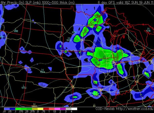
Sunday: Ditto. A nagging warm frontal boundary combined with a trough of low pressure aloft (unusually cold air in the upper atmosphere) may spark a few more showers and storms Sunday - perhaps not quite as widespread as Saturday, but no, I can't promise a dry Sunday. Why should this weekend be any different?
Termination Of "High Water Declaration" On Lake Minnetonka. "Effective immediately, the “High Water Declaration” on Lake Minnetonka has been terminated. However, the boating public must still comply with LMCD rules and regulations pertaining to speed limits that are established during normal water level periods. In particular:
* No person shall operate a watercraft in such a manner that its wash will endanger, or unnecessarily interfere with any person or property.
* No person shall operate a watercraft at a speed greater than minimum wake when within 150 feet from the shoreline, dock, or pier.
* “Minimum wake” means the wake moving out from a watercraft and trailing behind in a widening “V” is of insufficient size to affect other watercraft or to be detrimental to the shoreline.
* Some areas of the lake are subject to minimum wake limitations at all times.
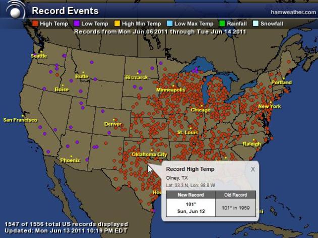
A Week's Worth Of Records. Check out the interactive Ham Weather graphic showing 1,556 records (mostly record highs) from June 6 through June 13, a week's worth. Pretty amazing.
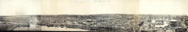
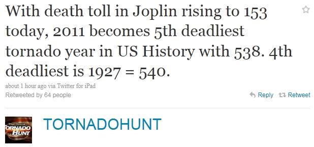
Sunday Was The Anniversary Of The New Richmond (Wisconsin) Tornado; Lessons Still To Be Learned. Here's a post from the local Chanhassen office of the National Weather Service focusing on the 1899 New Richmond tornado (called "cyclones" at the time). With 117 confirmed fatalities it was America's 9th deadliest tornado on record: "On June 12, 1899, one of the deadliest tornadoes in U.S. history occurred in New Richmond, Wisconsin, just about 30 miles northeast of the heart of the Twin Cities. This tornado struck soon after 6 pm, which was a particularly vulnerable time for the community of then 2,500, as the Gollmar Brothers Circus was in town and just ending their show. Because of this, an estimated hundreds of more people were in town, with many outside in the streets as the strong storm approached. The tornado tracked through the heart of New Richmond from southwest to northeast. There were 117 people killed, with 114 of them being in New Richmond. This tornado ranks as the 9th deadliest tornado in U.S. history. Hundreds of buildings were destroyed by the tornado, as seen in this spliced "panoramic view" (above) taken after."
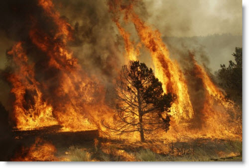
"Wallow Fire": On Track To Become Arizona's Largest Wildfire Ever? Here's an update from azcentral.com: "The massive Wallow Fire on Monday was on track to become the largest wildfire in Arizona history, as containment of the 452,155-acre fire still hovered at 10 percent. "Just because of the size and the burning in all of these areas, I believe it will eclipse Rodeo-Chediski" as the largest fire recorded in the state, said Jerome MacDonald, section chief for the Southwest Area Incident Management Team. All of the containment reported was in the northern area of the fire's reach, between Alpine and Greer, MacDonald said. The Rodeo-Chediski Fire, which began as two separate fires intentionally set by people in June 2002, consumed more than 468,000 acres and threatened the areas surrounding Show Low, Heber and Pinetop. The blaze destroyed 465 homes, burned 26 other buildings and led to the evacuation of some 50,000 people. Firefighters on Monday planned to complete containment lines against the Wallow Fire near the most recent communities threatened -- Luna and Reserve, along the New Mexico border -- before beginning controlled burnouts in the area Tuesday. Fire officials were also concerned by a section of the fire south of Greer, where flames had been jumping containment lines. Authorities said they could not say for sure when residents of Greer, Alpine and Nutrioso would be allowed to return home. MacDonald said the return of residents to Eagar and Springerville was nearly complete and had gone smoothly. Though air quality was still an issue in those areas, the concentration of smoke and other hazardous particles had diminished significantly."
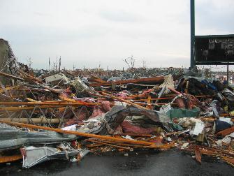
Lessons, Then And Now. The image above is from Joplin, after an EF-5 tornado swept through the city. The National Weather Service has some timely advice on lessons learned:
Some general ideas to keep in mind regarding severe weather and tornadoes:
- Preparedness for severe weather is key, whether in the home, workplace, school, and elsewhere.
- When able, try to check into the forecast and when there are severe thunderstorm possibilities. An NWS web site to help you is the Storms Prediction Center site, particularly their outlooks. Also, like the NWS Twin Cities on Facebook, and follow our posts there ahead of potential severe weather.
- Do you and all your family know the difference between a tornado watch and a tornado warning? Review.
- During a tornado watch, when the skies darken, remember the possibility of tornadoes does exist. Some action may need to be taken then, so if a warning is issued, you can more swiftly react.
- Have a way, preferably multiple, to receive a warning if one is issued. Our web page is one way to see warnings for the local area. NOAA Weather Radios can also alert you to a warning issuance for your county. Mobile devices also have applications that can alert you to weather warnings.
- Large outdoor venues or areas that have hundreds of people outside, such as just before the New Richmond tornado, can at times be even more vulnerable. For planners and workers of such venues or events, strongly consider preparedness and possibly StormReady.
- Know what you would do if a tornado warning were issued for your area, whether you be at home, working, in your car, camping, a baseball game, etc. See safety suggestions here.
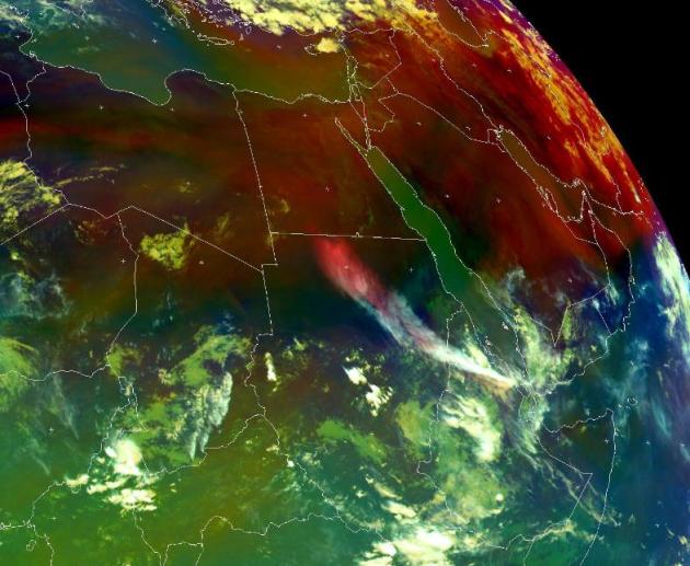
Volcanic Eruption In Eritrea. A new volcano ("Nabro") is creating concern in the northern Red Sea area, as reported by the Irish Times: "The Anabro (Nabro) volcano in the Northern Red Sea Region of Eritrea has erupted sending an ash plume more than 13.5 kilometres into the sky and threatening to disrupt air traffic across eastern Africa and as far away as the Middle East. Part of the Afar Triangle, the stratovolcano is one of many volcanic caldera complexes in the north easternmost part of the East African Rift valley region. Nabro is located in the Danakil Depression, close to Eritrea’s border with Ethiopia and north of Djibouti, and has not erupted in at least 150 years. It is the most prominent of 3 large volcanoes (Nabro, Dubbi, Mallahle) in the region, each containing a large summit caldera. The volcano erupted at 2103 GMT Sunday evening. The Volcanic Ash Advisory Center (VAAC) said Monday that the 5,331 ft volcano has resulted in a large ash plume of up to 13.5 kilometres (8 miles) high. The scale of the eruption, compared to the ongoing eruption in Chile and 2010′s eruption at Eyjafjallajökull in Iceland, remains unclear. The eruption was preceded by seven moderate earthquakes yesterday afternoon. A 5.6 magnitude quake at 21.03 GMT signalled the start of the eruption. The quake was centred 48 km south of the town of Edd (pop 11,259) and 199 km southwest of the city of Al-h’udaydah (pop 617,871). A 4.6 magnitude quake followed less than 35 minutes later. On Monday afternoon officials in Ethiopia warned citizens to protect themselves from the ash and smoke coming from the volcanic eruption. Asamara, the capital city of Eritrea, is also said to be affected by ash from the erupting volcano."
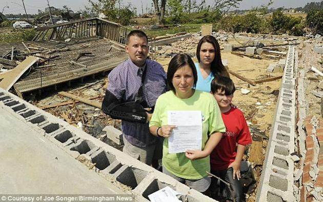
Alabama Tornado-Hit Family Denied Grant To Repair Home Because of "Insufficient Damage". I can't quite wrap my brain around this article. Insufficient damage? Look at what's left of their home! The U.K.'s Daily Mail has the details: "Displaced families in tornado-ravaged Alabama are outraged after being denied federal aid to rebuilt their flattened homes - due to "insufficient damage." Jefferson County resident Jonathan Stewart said he laughed in shock after the Federal Emergency Management Agency (FEMA) claimed the house his family lost in the deadly April 27 twister was "not unsafe to live in." The devastating reality is the house is now a concrete slab surrounded by rubble."
Professor's Study of Tornado Resistance Could Protect Buildings, Lives. Here's an interesting story on tornado research, specifically on how to strengthen and reinforce homes and other structures to be able to better withstand tornadic winds, from tribstar.com: "TERRE HAUTE — Few forces of nature cause more damage than a tornado, and getting to the bottom of those storms is one Rose-Hulman professor’s goal. In July, Fred Haan returns to Iowa State University for a summer of collaborative research about the structural impact of winds and what can be done to make buildings more resistant. The Rose-Hulman Institute of Technology professor of mechanical engineering has served as collaborative faculty with Iowa State projects for the last 10 years, and he said this interest stems back to a childhood mixture of fascination and fear. Haan’s work was recently featured in a USA Today article about research aimed at making buildings stronger. Among other projects, he works with a tornado simulator and 5-inch-tall model houses to test for loads. “It doesn’t take building a concrete house to make it more wind resistant,” he said last week inside his office at Rose-Hulman."
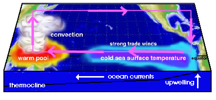
Forecasters Say La Nina Climate Condition Is Over. As we've been reporting over the past few days, NOAA data (weather buoys in the Pacific and satellite imagery of ocean water) indicate that La Nina, the cooling of equatorial Pacific Ocean water, is now over. Fosters.com has a recap:
"WASHINGTON (AP) — The La Nina phenomenon that may have helped boost last year's hurricane season and this spring's tornadoes has ended. The Climate Prediction Center said Thursday that the periodic cooling of the tropical Pacific Ocean known as La Nina (la NEEN-ya) ended in May and the ocean returned to neutral conditions. La Nina and its warm-water opposite El Nino (el NEEN-yo) can affect weather worldwide. The end of this La Nina could be good news. La Nina years sometimes have more hurricanes and tornadoes than average, and some researchers say the phenomenon may have contributed to the twister outbreak in May. In addition, last summer there were 19 named tropical storms and hurricanes in the Atlantic and Caribbean, though only one, Hermine in September, did much damage in the United States."
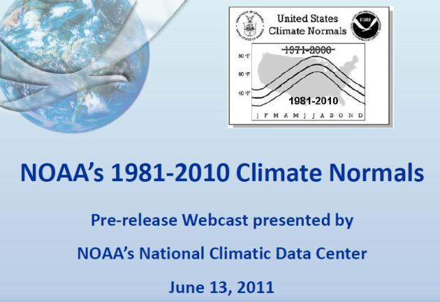
New Normals. Up for a little light reading? NOAA just released the latest climate "normals" for the USA. When you hear the "average high" or "average low", it's a running, 30-year average. Data was just updated to show the first decade of the 21st century. Not sure what the implications are (yet), but my hunch is that the new normals will show a distinct warming trend, since many of the years from 2000-2010 were among the warmest ever measured. For a look at how the new normals were calculated click here - the full data set is set to be released on July 1. For continuity the same 5,053 weather observation sites were used. Averaged together (all reporting stations) the inclusion of the 2000-2010 data showed a .6 F. warming trend nationwide for the latest, running, 30-year averages.
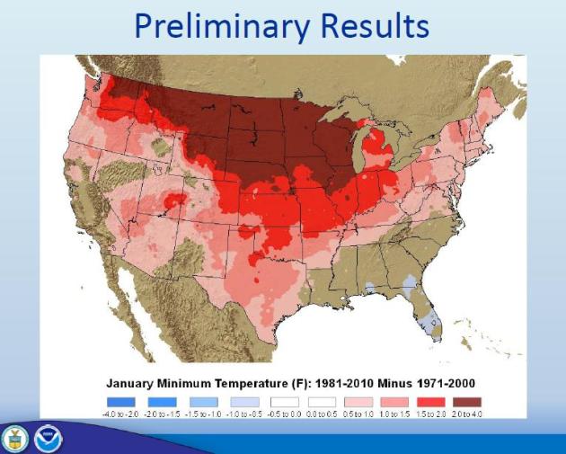
Winters Trending Milder. Here is one image taken from the NOAA "new normals" data set, which will be released in its entirety on July 1, showing the difference between the 1981-2010 normals and the older 1971-2000 numbers. The data shows a distinct warming trend, factoring in the last decade's worth of highs and lows, a 2-4 temperature increase for January low temperatures. Portions of Florida showed a very slight cooling trend.

For Instant Ratings, Interviews With A Checkbook. ABC and NBC are reportedly paying for high-visibility interviews on their morning shows, as reported by the New York Times: "Before the subjects of headlining news stories agree to a television interview these days, some have one question: how much money can I make? ABC and NBC, embroiled in a fight for viewers in the mornings, are increasingly in the news for their willingness to pay thousands of dollars to gain exclusive access to news subjects. The practice was especially visible last week when ABC News ran an exclusive interview with Meagan Broussard, one of the women who was sent lewd photos by Anthony Weiner, after the network paid her about $15,000 for photos. ABC said its extensive reporting, including the interview, led to Mr. Weiner’s admissions about his online behavior. Also last week, ABC announced that Diane Sawyer had secured the first-ever interview with Jaycee Lee Dugard, the young woman held captive for 18 years in California. ABC declared that it had not paid any fee for the interview, but last year, according to a longtime ABC News executive aware of the deal, the network paid a six-figure sum for rights to home movies of Ms. Dugard. The networks provide perks besides paychecks, too: When David Goldman, a subject in a custody battle over his son, brought his son back to the United States from Brazil last year, he was provided both a ride on a private jet by NBC and accommodations at Universal Studios, an amusement park partly owned by NBC’s parent company. Mr. Goldman’s network of choice for interviews was NBC, and he mentioned being “grateful” for their support."
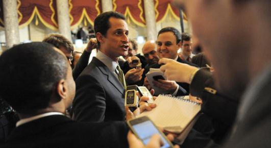
Technology And The Political Sex Scandal. All these new digital devices, social media, and an always-on, 24/7 world of connectivity has created all kinds of new ways for all of us (including politicians) to get into trouble, as reported by the New York Times: "In 1791, while serving as secretary of the Treasury, Alexander Hamilton began an affair with Maria Reynolds, being blackmailed by her husband for several years to allow it to continue. When a muckraker exposed the affair and the cover-up, Hamilton turned to the communications technology of the day to defend himself, publishing a pamphlet in which he argued that he had never abused any public resources. More than two centuries and many scandals later, Twitter has replaced pamphlets as the medium of the moment – and become the new means for politicians to engage in sexual misconduct. Now, it is Representative Anthony D. Weiner, under pressure to resign after he first denied and then admitted “sexting” lewd messages and pictures of himself in his underwear via Twitter to college students and a porn star, among other young women. (The New York Democrat has defended himself — plus ça change — by arguing that he did not abuse public resources in his misdeeds.) Certainly there are things particular to Washington that make sex scandals as predictable as swampy weather in July — and to politicians in general, especially lately, as the recent scandals involving Arnold Schwarzenegger (child out of wedlock) and John Edwards (child out of wedlock, and last week indicted for allegedly lying over his affair) have served to remind."
* "Some Gaffs, But Now On Twitter." An article from the New York Times.

The Next Crash Could Be A Lot Worse. I hesitated whether I should include this story, but there are some worrying trends out there - real estate has been a drag on the stock market, and there are growing concerns that we're heading into a "double-dip." I have enough trouble predicting the weather, but in the spirit of full disclosure, here's a recent article from analyst Michael Snyder at seekingalpha.com: "Well, it's official. U.S. stock prices have fallen for six weeks in a row. So will next week make it seven? The last time stocks declined for seven weeks in a row was back in May 2001 when the "dot-com" bubble was bursting. At this point, the Dow has declined by approximately 5 percent since the beginning of June. Things don't look good. So exactly what is going on here? Well, it is undeniable that the recent mini-bubble in stocks has been too good to be true. The S&P 500 had surged nearly 30 percent since last September. Much of this has been fueled by the Federal Reserve's latest round of quantitative easing, but now that is coming to an end in a few weeks and investors are a bit spooked. Meanwhile, wars and revolutions are sweeping the Middle East, Japan is dealing with the damage caused by the tsunami and by Fukushima, Europe is trying to figure out how to bail out Greece again and the U.S. debt crisis is continually getting worse. In addition, wave after wave of bad economic news is certainly not helping the mood on Wall Street. In many ways, a "perfect storm" is developing and many are now extremely concerned about what the rest of 2011 is going to bring for Wall Street."

Larry Summers: More Stimulus Needed For Jobs Crisis. Here's a story from Reuters and Huffington Post: "CAMBRIDGE, Mass., June 12 (Reuters) - Even with the massive 2008-2009 policy effort that successfully prevented financial collapse and depression, the United States is now halfway to a lost economic decade. Over the last five years, from the first quarter of 2006 to the first quarter of 2011, the U.S. economy's growth rate averaged less than 1 percent a year, about like Japan during the period when its bubble burst. At the same time, the fraction of the population working has fallen from 63.1 percent to 58.4 percent, reducing the number of those with jobs by more than 10 million. The fraction of the population working remains almost exactly at its recession trough and recent reports suggest that growth is slowing. Beyond the lack of jobs and incomes, an economy producing below its potential for a prolonged interval sacrifices its future. To an extent that once would have been unimaginable, new college graduates are this month moving back in with their parents because they have no job or means of support. Strapped school districts across the country are cutting out advanced courses in math and science and in some cases only opening school four days a week. And reduced incomes and tax collections at present and in the future are the most important cause of unacceptable budget deficits at present and in the future."

Target: Bin Laden. The Death And Life Of Public Enemy Number One. ABC News has released an excerpt of an e-book they just released about the hunt for Bin Laden: "What follows is an exclusive excerpt from one of several chapters by ABC News' Chief Investigative Correspondent Brian Ross.
Chapter Five: The Hunt for Bin Laden
The United States began its hunt for Osama bin Laden at a time when few Americans had even heard his name. It was 1996 when President Bill Clinton first gave the order to the CIA to capture or kill the al Qaeda leader. "We had linked him to two bombings in Saudi Arabia that killed U.S. soldiers and the president said go after him," recalled Richard Clarke who was the White House counter-terrorism adviser, and is now a consultant to ABC News. Twenty-four U.S. personnel were killed in October 1996, just months after bin Laden had issued a fatwa, a religious order, against U.S. military personnel. The Clinton White House plan was for the CIA to capture him in Afghanistan with the help of a local tribe and then bring him to the United States on a CIA private jet where he was to be indicted. But the tribe that took the CIA's money failed to deliver, according to Clark, and bin Laden continued to plot against the United States from his safe haven in Afghanistan. ABC News correspondent John Miller made the trek to bin Laden's not-so-secret training camp for an exclusive interview with bin Laden, still largely unknown to the general public in May 1998."

Learning From A Brush With Death. Nothing like a near-death experience to get a person to look at life with "new eyes". CNN Money has the harrowing story: "FORTUNE -- How would going through a near-death experience change you? It's one of those questions that few of us ever ponder or could ever answer until, heaven forbid, it happens. On April 28, 2010, Chris Licht, then the hard-charging executive producer of MSNBC's Morning Joe, suffered a brain aneurysm -- putting him closer to death's door than he ever wanted to be. Eight days in the hospital and weeks of recovery offered Chris some time to think about his non-stop Blackberrying, yelling at work, not paying enough attention to his family, and losing touch with his friends. Chris, 39, explores all this, in a slim volume, What I learned When I Almost Died (Simon & Schuster.) I know a little bit about the story. As a regular guest on Morning Joe, I've worked with Chris and always marveled at his ability to juggle, turn on a dime and most of all thrive in the shark tank that is the big time TV news. His book is a great read that will probably make you think twice about your work/life balance, plus if you're a Morning Joe junkie, it's got some nice nuggets."
Looxcie Updates Always-On Wearable Video Camera. Check this out - you can "wear" a camera and either record clips, or - using a proprietary app - stream live footage. Whatever you see goes on live on the 'net. This is going to take social networking (and coverage of breaking news and weather) to a new level. Gizmag.com has the details:
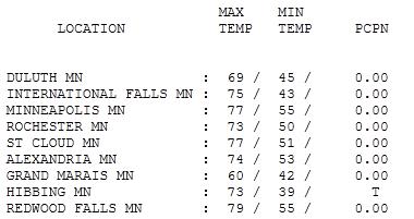
Lukewarm Monday. After a gray start (with T-storms weakening over far southwestern Minnesota) the sun came out by afternoon, luring the mercury into the 70s across most of Minneosta. Highs ranged from 69 at Duluth to 77 at St. Cloud and the Twin Cities, 79 at Redwood Falls.
Paul's SC Times Outlook for St. Cloud and all of central Minnesota:
TODAY: More clouds than sun, a few T-storms, stiff breeze. Winds: SE 10-20. High: 71
TUESDAY NIGHT: Mostly cloudy, a stray shower or T-storm possible. Low: 58
WEDNESDAY: Scattered storms, some heavy, still on the cool side. High: 70
THURSDAY: Drier day - partly sunny skies. Low: 56. High: 75
FRIDAY: Plenty of sun, warming up - feels like summer again. Low: 60. High: 79
SATURDAY: Hazy sun; few showers & T-storms, best chance central/northern MN. Low: 63. High: 81
SUNDAY: Intervals of sun, chance of few spotty T-storms statewide, warm and muggy. Low: 64. High: near 80
MONDAY: Unsettled, muggy. Few T-storms around town. Low: 65. High: 82

No Locust on Doppler
My doctor has a good sense of humor. In an e-mail appointment reminder he wrote, "Friendly reminder. Unless, of course, tornadoes, straight line winds, severe thunderstorms, hail, heavy fog, suffocating humidity, tsunamis, or other weather events prevent you from attending." Amen.
America's weather pattern has been almost biblical in recent months; torrential rains up north, while a billion-dollar drought grips 8 states from Texas to Florida. Meanwhile Snowbird Ski Resort in Utah will remain open through the 4th of July, for only the third time in history. 100+ from Orlando to Dallas, while March-like skiing conditions persist near Salt Lake City. Cue the theme from the Twilight Zone.
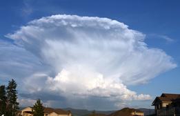
The best chance of T-storms through midweek will come over western Minnesota; a few may be severe. The atmosphere draped over the Twin Cities should be a bit too cool (and stable) for any violent weather close to home this week. Comfortable 70s linger into midweek; low 80s return Friday into the weekend, making the lake a more tempting target. Scattered T-storms are expected both Saturday and Sunday, but at least it will feel a bit more like summer. Yes, summer is coming, slowly but slowly. A sustained "warm front" would be nice.
"Climate Change Is Real: An Open Letter From The Scientific Community". This entry comes courtesy of "The Conversation" and "Climate Change: The Next Generation":
"The overwhelming scientific evidence tells us that human greenhouse gas emissions are resulting in climate changes that cannot be explained by natural causes. Climate change is real, we are causing it, and it is happening right now.
Like it or not, humanity is facing a problem that is unparalleled in its scale and complexity. The magnitude of the problem was given a chilling focus in the most recent report of the International Energy Agency, which their chief economist characterised as the “worst news on emissions.” Limiting global warming to 2 °C is now beginning to look like a nearly insurmountable challenge. Like all great challenges, climate change has brought out the best and the worst in people. A vast number of scientists, engineers, and visionary businessmen are boldly designing a future that is based on low-impact energy pathways and living within safe planetary boundaries; a future in which substantial health gains can be achieved by eliminating fossil-fuel pollution; and a future in which we strive to hand over a liveable planet to posterity. At the other extreme, understandable economic insecurity and fear of radical change have been exploited by ideologues and vested interests to whip up ill-informed, populist rage, and climate scientists have become the punching bag of shock jocks and tabloid scribes. Aided by a pervasive media culture that often considers peer-reviewed scientific evidence to be in need of “balance” by internet bloggers, this has enabled so-called “sceptics” to find a captive audience while largely escaping scrutiny. Australians have been exposed to a phony public debate which is not remotely reflected in the scientific literature and community of experts. Beginning today, The Conversation will bring much-needed and long-overdue accountability to the climate “sceptics.” For the next two weeks, our series of daily analyses will show how they can side-step the scientific literature and how they subvert normal peer review. They invariably ignore clear refutations of their arguments and continue to promote demonstrably false critiques. We will show that “sceptics” often show little regard for truth and the critical procedures of the ethical conduct of science on which real skepticism is based. The individuals who deny the balance of scientific evidence on climate change will impose a heavy future burden on Australians if their unsupported opinions are given undue credence. The signatories below jointly authored this article, and some may also contribute to the forthcoming series of analyses."
Cold Weather Events To Persist As Planet Warms. Counterintuitive? Absolutely. Ars Technica has the story: "Current projections estimate that the globe will be about 2-5°C (3.6-9°F) warmer by the end of the century, depending on future emissions of greenhouse gases. It's sometimes assumed that climate change implies a smooth, linear march up the thermometer, with each season slightly warmer than that of the previous year, without exception. Seen this way, any abnormal cold snap would appear to falsify the predictions of climate science. Obviously, that's a simplistic view of the climate, so what do climate models really project the future to be like? A recent paper published in Geophysical Research Letters takes a look at how cold weather events are expected to change in a warming climate. Climate projections are based on models that incorporate every bit of physics and chemistry we are able connect to Earth's climate, and they do the difficult work of calculating everything out for each grid cell on the planet at each time interval. A number of research groups (such as NASA and the National Center for Atmospheric Research) develop their own models, so the average of multiple models is often used to generate more robust projections, like those published by the Intergovernmental Panel on Climate Change. The authors of this recent paper used nine of those models to compare cold events during the last decade of the 21st century with those of the last decade of the 20th century, based on a middle-of-the-road greenhouse emissions scenario (IPCC scenario A1B). The team characterizes "extreme cold events" for each year in three ways: intensity, duration, and frequency. Intensity is calculated as the lowest 3-day average of maximum daily temperatures. Duration is defined as the greatest number of consecutive days that dip below freezing each year. Frequency is simply the total number of days that reach freezing temperatures in that year."
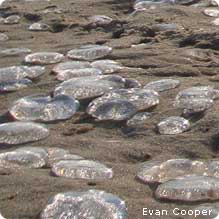
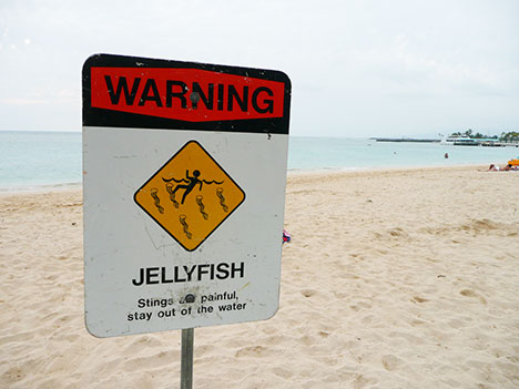
Explosion In Jellyfish Numbers May Lead To Ecological Disaster, Scientists Warn. A fun day at the beach has been marred by a dramatic increase in (painful) jellyfish along America's Gulf and East coast. Is there a link to climate change? The U.K.'s Guardian has the story: "Global warming has long been blamed for the huge rise in the world's jellyfish population. But new research suggests that they, in turn, may be worsening the problem by producing more carbon than the oceans can cope with. Research led by Rob Condon of the Virginia Institute of Marine Science in the US focuses on the effect that the increasing numbers of jellyfish are having on marine bateria, which play an important role by recycling nutrients created by decaying organisms back into the food web. The study, published in the journal Proceedings of the National Academy of Sciences, finds that while bacteria are capable of absorbing the constituent carbon, nitrogen, phosphorus and other chemicals given off by most fish when they die, they cannot do the same with jellyfish. The invertebrates, populating the seas in ever-increasing numbers, break down into biomass with especially high levels of carbon, which the bacteria cannot absorb well. Instead of using it to grow, the bacteria breathe it out as carbon dioxide. This means more of the gas is released into the atmosphere. Dr Carol Turley, a scientist at Plymouth University's Marine Laboratory, said the research highlighted the growing problem of ocean acidification, the so-called "evil twin" of global warming. "Oceans have been taking up 25% of the carbon dioxide that man has produced over the last 200 years, so it's been acting as a buffer for climate change. When you add more carbon dioxide to sea water it becomes more acidic. And already that is happening at a rate that hasn't occurred in 600 million years."
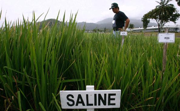
The Race For Climate Change Crops. Considerable effort and resources are going into new strains of crops that are more resistant to weather extremes: drought, flood, extreme heat, etc. Khaleejtimes.com has the story:
"Charlie Bragg gazes across his lush fields where fat lambs are grazing, his reservoirs filled with water, and issues a sigh of relief. Things are normal this year and that’s a bit unusual of late. His 7,000-acre farm near the Australian town of Cootamundra is testament to the plight facing farmers around the globe: increasingly wilder weather is making food production more unpredictable. It’s the new normal they must prepare for. Bragg’s farm in New South Wales state has been in the family for generations and has weather records for the area stretching back 110 years. After seven years of costly drought, the weather switched last year to unseasonably wet with flooding rains. “It’s screaming to me that things are getting hotter and drier at different times of the year,” said the 40-year-old Bragg during a recent visit to his property, about two hours drive to the west of Canberra, the Australian capital. “Our summers are getting wetter and if this trend continues, then we will have to find different means of farming,” he said. Across the globe, rising temperatures and more intense droughts, floods and storms are forcing a rethink in how to grow food, from breeding hardier crop varieties and changing planting times to complete genetic overhauls of plants. Growing populations, changing diets and insatiable demand for grains, meat and vegetables is putting pressure on global food production and prices like never before."
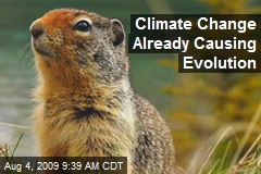
Can Evolution Outpace Climate Change? U.S. News and World Report and NSF, the National Science Foundation, have the story: "Animals and plants may not be able to evolve their way out of the threat posed by climate change, according to a UC Davis study of a tiny seashore animal. The work was published today (June 8) in the journal Proceedings of the Royal Society B. The tide pool copepod Tigriopus californicus is found from Alaska to Baja California — but in a unique lab study, the animals showed little ability to evolve heat tolerance. “This is a question a lot of scientists have been talking about,” said study co-author Eric Sanford, an associate professor of evolution and ecology at UC Davis and a researcher at the university’s Bodega Marine Laboratory. “Do organisms have the ability to adapt to climate change on a timescale of decades?” UC Davis graduate student Morgan Kelly, the first author of the paper, collected copepods from eight locations between Oregon and Baja California in Mexico. The tiny shrimplike animals, about a millimeter long, live in tide pools on rocky outcrops high in the splash zone."
No comments:
Post a Comment