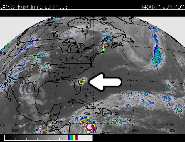
* Small potential for Tropical Storm Arlene in the Gulf of Mexico within the next 48 hours.
* Slight severe risk today (Red River Valley and central Minnesota).
* 85-90 F. on Friday, followed by a slight cooling trend over the weekend.
* Nice weekend? Sunshine should be the rule, 75-80 north, low 80s southern Minnesota, a drop in humidity.
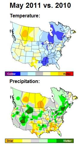
* May recap: 3" wetter than average over parts of central Minnesota (details below).
* "Figuring in the Japanese earthquake and tsunami, global insured-disaster losses are also on record pace, having already passed $50 billion this year, according to insurance broker Aon Corp." - CBS Marketwatch article "More Misery In Cards As Hurricane Season Kicks In".
* “The country (USA) is two decades behind in taking action because both parties are in thrall to Big Oil and Big Coal,” says Sachs. “The airwaves are filled with corporate-financed climate misinformation.” - Newsweek article "Are You Ready For More?"
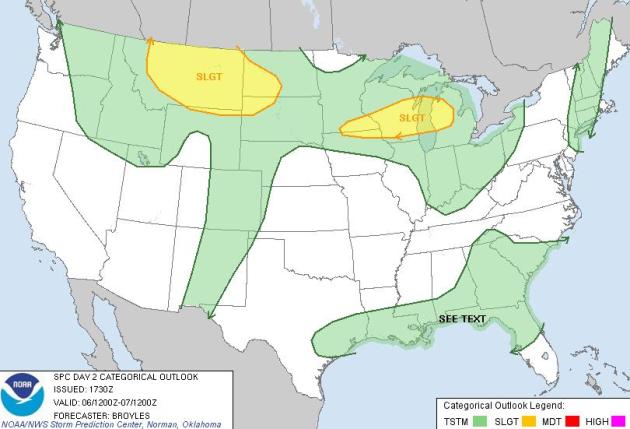
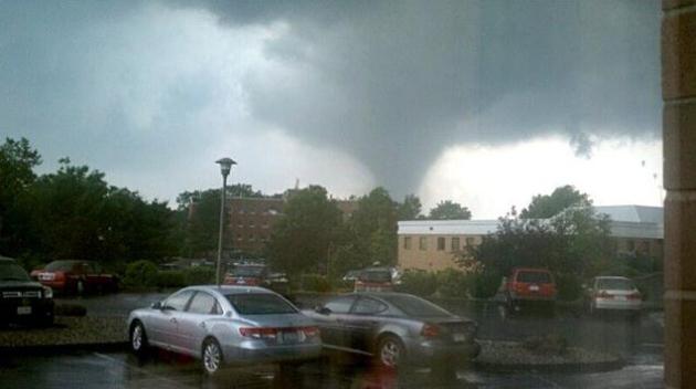
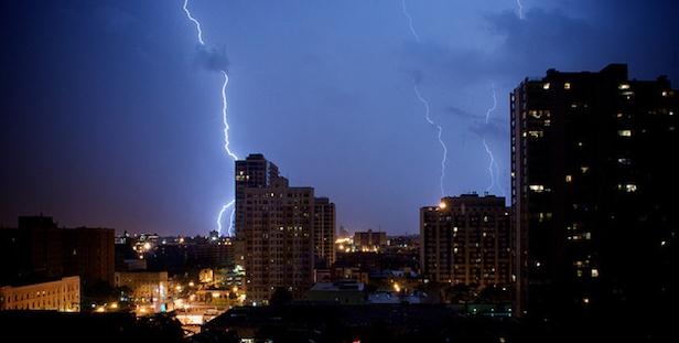
Thursday Severe Threat. SPC has much of central and northwestern Minnesota in a slight risk of severe weather today. A warm front lifting northward across the state will create favorable wind shear for a couple of isolated "supercell" thunderstorms. A severe storm watch may be issued later today, the best chance north/west of St. Cloud.
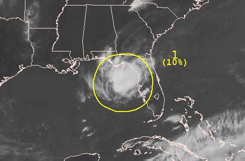
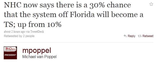
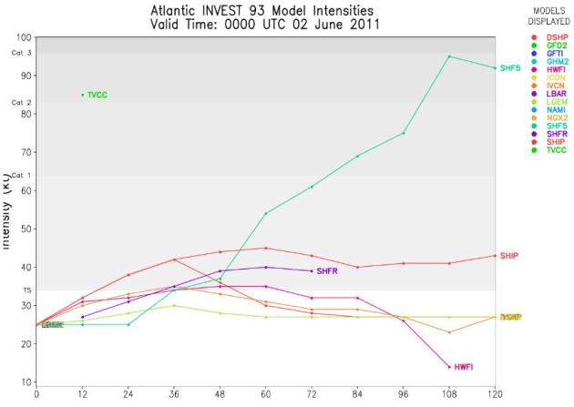
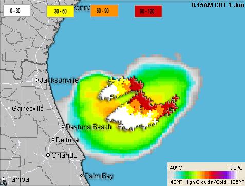
Low Probability Event. There's only a 1 in 10 chance of this tropical wave intensifying into a tropical storm (too much wind shear aloft). Here's the latest from NHC:
DISORGANIZED SHOWERS AND THUNDERSTORMS OVER THE FAR NORTHEASTERN
GULF OF MEXICO ARE ASSOCIATED WITH AN ELONGATED LOW PRESSURE AREA.
SIGNIFICANT DEVELOPMENT OF THIS SYSTEM IS UNLIKELY AS ENVIRONMENTAL
CONDITIONS ARE NOT PARTICULARLY CONDUCIVE OVER THE GULF OF MEXICO.
THERE IS A LOW CHANCE...10 PERCENT...OF THIS SYSTEM BECOMING A
TROPICAL CYCLONE DURING THE NEXT 48 HOURS AS IT MOVES
WEST-SOUTHWESTWARD AT 25 MPH.
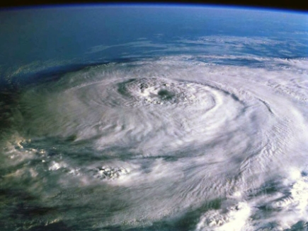
Hurricane Season Starts Today. Forecast: Warmer Seas Could Generate More Tropical Storms. Highlands Today has more details: "SEBRING - With 525 fatalities, 2011 has turned out to be one of the deadliest tornado seasons since 1953. The National Oceanic and Atmospheric Administration and Colorado State University have predicted that 2011 may be a more active hurricane season, as well. Is there a connection? "I don't see a correlation between tornado and hurricane seasons," said Channel 8 weather forecaster Steve Jerve. "It's easy to want to try to link weather events together." Some attribute tsunamis and earthquakes with weather events. Not so, says Jerve, who is certified by the American Meteorological Society and has been forecasting Florida weather for 28 years. "I have heard that cool Pacific waters are contributing to cooler temperatures, and thus affecting the jet stream that pushes this cool air up against warm and humid air in the Plains, Midwest and South," Jerve said. But, he reminded, April and May are always tornado months. "It's extreme this year, but similar weather has occurred in the past," he said. The difference is that in the media age, we have more storm chasers to pass along information, larger cities to be hit by tornadoes, and more media to cover the human stories. Jerve said Florida is in a weakening La Niña phase this storm season, and in a neutral phase between El Niño, which, historically, means cooler water and more hurricanes. "Any effect from either La Niña or El Niño will be minimal this year," Jerve said. "Our more active season that is forecast by NOAA, Colorado State University and others, is largely due to the 25- to 30-year cycle of ocean heat transfer." Those 2 to 3 degrees Celsius warmer sea surface temperatures put the Atlantic in a more active cycle that started in 1995."
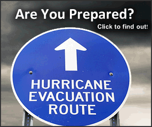
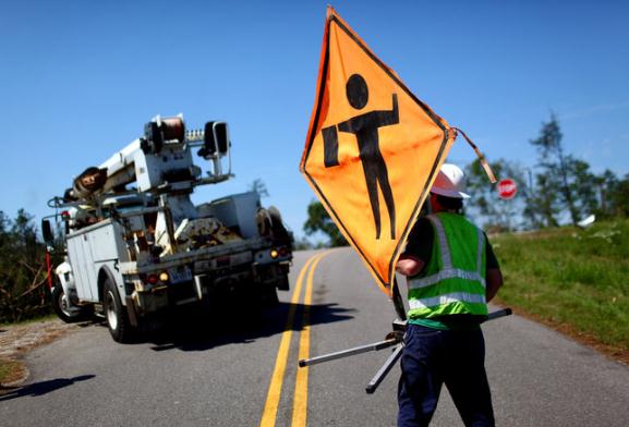
FEMA: Are You Ready? Plan, Prepare For Hurricane Season. Some useful advice for the 75 million plus U.S. residents of "hurricane alley" from FEMA: "June 1 marks the start of another hurricane season in the United States, even as the recovery from the historic tornado outbreaks continues in the southeast. NOAA's Climate Prediction Center has estimated six to 10 hurricanes this season, with three to six of those expected to be Category 3 or above. FEMA is prepared to respond to the needs of states in hurricane-prone areas, but any federal response needs to be paired with citizen preparedness— in businesses and at home. “You can’t know far ahead of time when it will be your community in the path of a hurricane. If you wait until the storm is bearing down on you, you may forget important things,” said FEMA Regional Administrator Phil May. “Plan ahead, stay safe and stay informed.” Being prepared makes a big difference in disasters, but it doesn’t have to come at a big cost. A quick look around your house or apartment can get you almost everything you need to build an emergency supply kit, which should include three days of food and water, prescription medication, battery-powered or hand-crank radio, flashlight, spare batteries, first aid kit, can opener, local maps, moist towelettes, toilet paper, garbage bags and plastic ties for personal sanitation. A complete list of recommended items for an emergency supply kit can be found at www.ready.gov, FEMA’s emergency preparedness website. Having the proper supplies early in a disaster is vital, but so is having a communication plan to stay in touch with family members. Your family may not be together when disaster strikes, so it is important to know how you will contact one another, how you will get back together and what you will do in case of an emergency. You should also share your evacuation plans, so others know that you are out of harm’s way. Learn about the emergency plans that have been established in your area by your state and local government, such as shelters and evacuation routes. Have different sources of information in case one is not working- don’t rely on just TV, radio, or the internet. A smartphone can be a great resource as well. FEMA’s mobile site, m.fema.gov, allows disaster survivors to apply for assistance, locate Disaster Recovery Centers and Red Cross shelters."

- by Kevin J. Kikta, DO
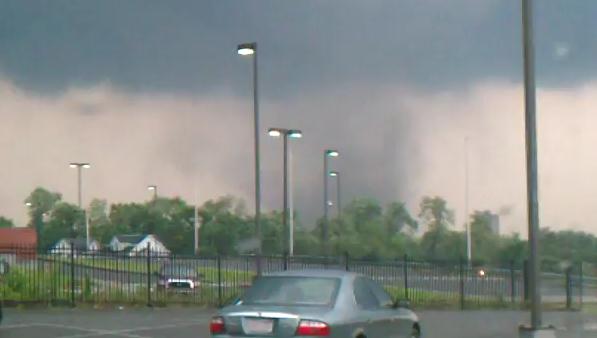
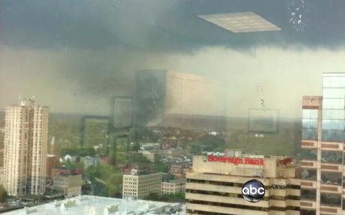
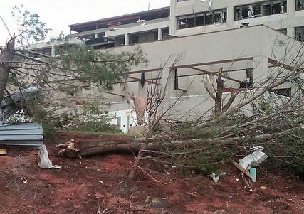
4 Fatalities In Springfield. ABC News has the story - and some spectacular footage of the (huge) tornado that swept acrosss central Massachusetts. "Multiple tornadoes slammed Massachusetts, destroying buildings, flipping vehicles and leaving at least four people dead and dozens injured.The Massachusetts twisters hit as unstable weather threatened the entire Northeast, bringing tornado watches to Philadelphia, New York and Boston.The situation in western and central Massachusetts was so bad that Gov. Deval Patrick declared a statewide state of emergency, calling up 1,000 members of the National Guard. Two of the four fatalities in Massachusetts occurred in Westfield, and there was one each in West Springfield and Brimfield, officials said. Two tornado touchdowns were confirmed -- one in the Springfield area and a larger one in the Westfield area, Patrick said. ABC News Boston affiliate WCVB earlier reported additional tornadoes confirmed in the Massachusetts communities of Wilbraham, Monson and Oxford. Patrick said at least 19 Massachusetts communities were affected by the twisters."
More Weather Videos:
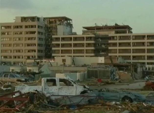
More before/after pix from Joplin:
http://www.nytimes.com/interactive/2011/05/27/us/joplin-panoramas.html
MI stormlapse yesterday:
http://www.youtube.com/watch?v=bN6Wu4VpOzA&hd=1
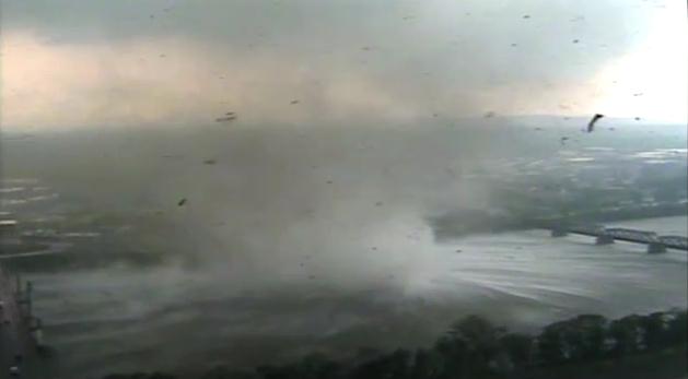
MO river flooding in OMA... starts about 3:00:
http://www.youtube.com/watch?v=YY5d_F4epaI&hd=1
Dakota Dunes sandbagging SUX, IA/SD along MO river:
http://www.youtube.com/watch?v=WNmEi6KBOSQ&hd=1
Pierre, SD spillway:
http://www.youtube.com/watch?v=Vz4nmlMxMrs&hd=1
http://www.nytimes.com/interactive/2011/05/27/us/joplin-panoramas.html
MI stormlapse yesterday:
http://www.youtube.com/watch?v=bN6Wu4VpOzA&hd=1
MO river flooding in OMA... starts about 3:00:
http://www.youtube.com/watch?v=YY5d_F4epaI&hd=1
Dakota Dunes sandbagging SUX, IA/SD along MO river:
http://www.youtube.com/watch?v=WNmEi6KBOSQ&hd=1
Pierre, SD spillway:
http://www.youtube.com/watch?v=Vz4nmlMxMrs&hd=1
Significant Weather Events:
- The month began with the coolest run-up week to Mother’s Day since 2005, suppressing seasonal demand.
- A warm up occurred in week 2. It was the warmest 2nd week of May since 2004, and the driest since 2007. These warm and dry conditions resulted in favorable demand for Spring products, and also supported traffic into many locations, particularly in the East.
- Week 3 experienced a flip to cool and wet conditions. It was the coolest since 2002, and the wettest in over 18 years.
- The final week of the month trended near normal, although cooler than LY. A significant warm up in the East over the Memorial Day weekend supported demand for Spring and Summer apparel.
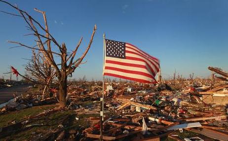
- Over 350 tornados were reported in the month of May, including many which hit population centers such as Joplin, Missouri. To date, the 2011 severe weather season has experienced the most fatalities since 1953.
- Flooding was prevalent in May. Several cities along the Ohio and Mississippi Rivers, including Memphis and Louisville, experienced flood waters near record levels. click for full report
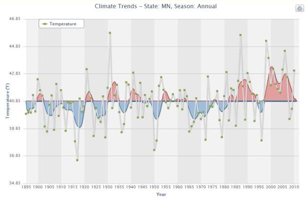
May Recap. Thanks to Minnesota State Climatologist Greg Spoden for providing these details. The full report is here.
- May 2011 precipitation totals were above average across most of Minnesota. Monthly rainfall totals were greater than five inches in many southwest, central, and east central Minnesota communities, topping the historical average by two or more inches. May rainfall totals fell short of the historical average by one-half inch to one inch in far north central and northeast Minnesota.
- Severe storms were a dominant feature of the national weather picture during the month of May. Minnesota was not spared nature's fury as severe weather was reported throughout the month in many locations.
- Monthly mean temperatures for May 2011 were somewhat below average across Minnesota. It was the sixth consecutive month of below-average temperatures.
- Stream discharge values remain very high in nearly every major Minnesota watershed. River levels remain near or above flood stage at some locations along the Red River, and a few locales along the Mississippi and Minnesota rivers.
- The U. S. Drought Monitor depicts most of Cook County and much of Lake County as "Abnormally Dry". Stream flow remains low in this area due to the lingering impact of precipitation deficits during the 2010 growing season and spotty rainfall thus far this spring.
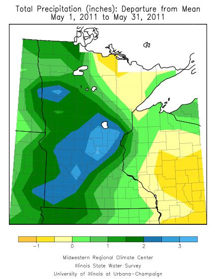
May Rainfall Departure From Normal. Yes, it was a soggy month, the most significant rainfall over southwestern and central Minnesota. Around St. Cloud May rainfall was 3" more than normal, according to the Midwestern Regional Climate Center.
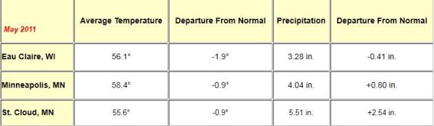
May Numbers. Rainfall in the Twin Cities was .80" greater than average, but St. Cloud saw a true soaking: 2.54" wetter than normal, according to the National Weather Servce. Temperatures for the month were close to 1 degree F. cooler than average in the Twin Cities and St. Cloud.
Sunny Saturday. A weak cool frontal passage should result in a light westerly breeze (8-15 mph) with a noticeable drop in humidity. The sun should be out much of the day, highs ranging from the upper 70s to low 80s. Right now it appears Saturday will be nicer day of the weekend for outdoor plans. A sunny, pleasant Saturday? I know - I'll believe it when I see it.
Sunday: Nearly As Nice. After a sunny morning and midday, a few instability showers and T-showers may pop up during the afternoon and evening hours Sunday. Expect a light breeze from the north at 5-10; much of the day should be dry with highs (once again) in the upper 70s to near 80.
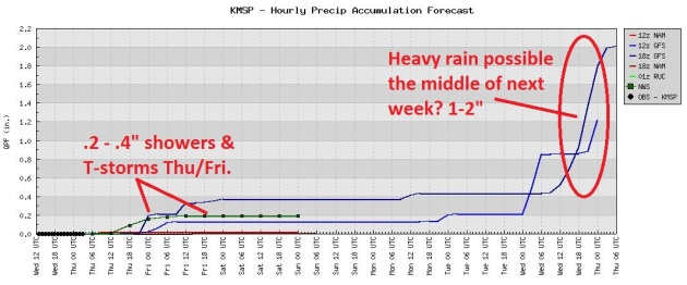
Rainfall Trends. A few hours of showers and (heavy) T-storms are possible today into Friday, followed by a rare dry spell Saturday into Tuesday of next week
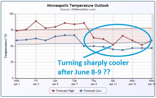
Temperature Trends. Good news for summer-lovers: temperatures run above average through the first 8 days of June, but the GFS model is hinting at a significant cooling trend for the second week of June, a few days with highs in the 60s? Check the temperature trends for your town by inputting your zip code here - courtesy of Ham Weather, a division of WeatherNation LLC.

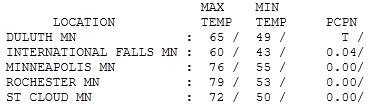

Good-Looking Wednesday. Under a sunny sky most of the day temperatures pushed into the 60s north, 70s central and south, ranging from 60 at International Falls to 72 at St. Cloud, 76 in the Twin Cities.
Paul's SC Times Outlook for St. Cloud and all of central Minnesota:
TODAY: Muggy with a few T-storms. A few severe storms central/northern MN? Winds: SE 15-30. High: 74
THURSDAY NIGHT: Humid with a few lingering T-storms. Low:68
FRIDAY: Hot sun, evacuate to the lake. T-storms far north. High: 86
SATURDAY: Plenty of sun, turning less humid. Winds: W 8-13. Low: 60. High: 80
SUNDAY: Lot's of sun - quite comfortable (isolated PM shower can't be ruled out - but most of the day should be dry). Winds: N 5-10. Low: 58. High: 79
MONDAY: Unsettled, few T-storms expected. Low: 62. High: 77
TUESDAY: Clouds increase, late storm? Low: 60. High: 75
WEDNESDAY: Lingering shower, T-storm possible. Low: 57. High: 73
Life Insurance
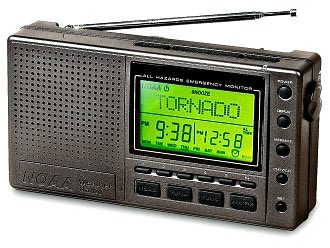
Your two best forms of severe weather life insurance: NOAA Weather Radio and a sturdy basement. Thanks to the last Ice Age vast glaciers left behind thick topsoil across most of the Upper Midwest, making it relatively affordable for Minnesotans to excavate for basements. According to a recent MSNBC story 77% of Midwest residents have basements. "Nationally 42% of new homes had basements in 1992, according to the Census Survey, compared to 30% in 2009." Details on the blog. Bedrock or a high water table can make it difficult, if not impossible, to put in a basement, yet it's the #1 thing you can do to lower your risk. 87% of Joplin residents didn't have a basement; only 11% of people living in the south have a full or partial basement.
A $30-50 NOAA Weather Radio is the only device that will set off a (loud) tone & wake you up at 3 am if a tornado is heading for your house. They make lovely birthday gifts.
There's a slight severe risk today over central & northern Minnesota, a few storms may brush the metro. After flirting with 90 tomorrow we cool down into the low 80s for the weekend. A sunny Saturday gives way to an isolated PM T-shower Sunday. Yes, better than last weekend.
Why Ethics Requires Acknowledging Links Between Tornadoes And Climate Change Despite Scientific Uncertainty. The truth: we still don't have enough research to draw a straight line between a warmer, wetter atmosphere and more (large/violent) tornadoes. Climate change is resulting in more evaporation and more water vapor in the air. Tornadoes thrive on low-level moisture, but the other (major) ingredient is wind shear. This is where the connection is shakier - no evidence (yet) that climate change impacts low-level wind shear. Penn State has a post focusing on what we do know, and lingering areas of uncertainty around tornadogenesis: "The outbreak of recent killer weather events including US tornadoes hitting Joplin, Missouri and Tuscaloosa, Alabama has everyone asking whether there is a link between tornadoes and human-induced climate change. In this writer's experience when US TV or radio weathermen are asked about the cause of recent strong tornadoes, they most always ignore climate change as a potential cause and point to a cyclical ocean circulation event known as La Niña as the cause of recent tornadoes if they comment on causation at all. Rarely is human-induced climate change mentioned as a cause or contributing factor in the recent outbreak of sever tornadoes although questions about causation are becoming more frequent on TV and newspapers in this writer's experience. This post argues that ethics requires acknowledging the links between tornadoes and climate change despite scientific uncertainties about increased frequency and intensity of tornadoes in a warming world. As we shall see there are certain aspects of atmospheric conditions necessary to produce violent tornadoes that climate change is enhancing while there are other atmospheric conditions necessary to form tornadoes about which scientists are uncertain exactly how a warming world will affect them. To figure out whether climate change will cause more intense and frequent tornadoes requires asking lots of smaller questions about the atmospheric conditions necessary to produce tornadoes and to determine how climate change will affect each of these various atmospheric conditions that combine to propagate tornadoes. Before discussing tornadoes, it is important to note that it is scientifically uncontroversial to conclude that climate change is causing more violent weather particularly in the form of: (a) more damaging thunder storms, (b) the kind of devastating flooding we have seen this year in Australia, Pakistan, Brazil, Columbia, Venezuela, along the Mississippi and the Tennessee valleys, and (c) more severe droughts such as those experienced this year in China, Brazil, and Texas. Similarly more intense hurricanes have been linked to climate change although it is still uncertain whether global warming will increase hurricane frequency. (Emanuel, 2005)"
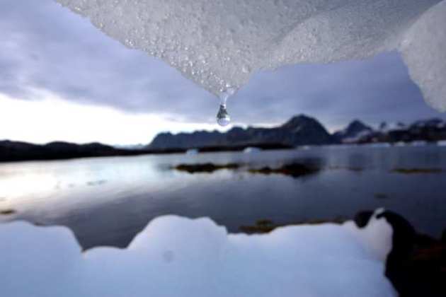
Global Warming Will Change Arctic Access. The UPI has the story: "LOS ANGELES, June 1 (UPI) -- Global warming will greatly change arctic transportation networks, limiting access in certain areas and vastly increasing it in others, U.S. researchers say. "Popular perception holds that climate warming will mean an opening up of the Arctic, but our study shows that this is only partly so," Laurence C. Smith, a UCLA professor of geography, said. "Rising maritime access for ships will be severely countered by falling vehicular access on land." Researchers say improved access by sea will benefit coastal communities, coastal resource-extraction operations, tourism, fishing and shipping concerns, while the loss of land access routes could hamper inland mining and timber operations, inland oil and gas drilling, as well as smaller inland communities often inhabited by indigenous peoples, a UCLA release reported Wednesday. "As sea ice continues to melt, accessibility by sea will increase, but the viability of an important network of roads that depend on freezing temperatures is threatened by a warming climate," said lead study author Scott Stephenson, a UCLA graduate student in geography."
Plans To Increase Resilience
Twenty six of the C40 cities already have plans to protect their infrastructure against climate change. Sao Paolo has sped up the implementation of a drainage master plan, and Copenhagen plans to become the world's first carbon neutral capital city. Jakarta is taking advantage of an anticipated uptick in rainfall to think about extending green areas."

Over 50 life insurance can be arranged at low prices with guaranteed acceptance and no medical examination required. This type of Life insurance over 50 for over 50 years is ideal to ensure that dependents can pay funeral expenses or the final closing. Since there is no doctor, no matter what condition you are you are always guaranteed to be accepted.
ReplyDelete