94 F. predicted high today (more clouds and a few T-storms should keep it a few degrees cooler).
79 F: maximum dew point reported at STC yesterday.
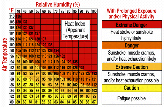
80 F. predicted dew point once again today, resulting in a heat index close to 110 by afternoon.
Severe storms possible later today, especially north/east of St. Cloud.
96-99 F predicted high on Wednesday, possibly the hottest day of the hottest week of summer. No storms to cool things off (temporarily) tomorrow.
57 F dew point returns by Thursday afternoon, meaning lless than HALF as much water in the air as today.
* 25% of America is under some sort of heat warning, an area roughly the size of Mexico (CNN).
7.45" rain in the St. Cloud metro since June 1; that's .95" wetter than normal as of July 18.
URGENT - WEATHER MESSAGE
NATIONAL WEATHER SERVICE TWIN CITIES/CHANHASSEN MN
725 PM CDT MON JUL 18 2011
EXCESSIVE HEAT AND HUMIDITY THROUGH MUCH OF THE WEEK AHEAD...
DUE TO A PROLONGED PERIOD OF THE HEAT AND HUMIDITY...AN EXCESSIVE HEAT WARNING REMAINS IN EFFECT FOR CENTRAL AND SOUTHERN MINNESOTA...INCLUDING THE TWIN CITIES...AND ALL OF WEST CENTRAL WISCONSIN...THROUGH 9 PM ON WEDNESDAY. AFTERNOON HEAT INDICES WILL EXCEED 105 DEGREES FOR SEVERAL HOURS BOTH TUESDAY AND WEDNESDAY AFTERNOON...WITH OVERNIGHT LOW TEMPERATURES ONLY FALLING INTO THE MIDDLE 70S TO LOWER 80S.
THE COMBINATION OF HOT TEMPERATURES AND HIGH HUMIDITY WILL COMBINE TO CREATE A DANGEROUS SITUATION IN WHICH HEAT ILLNESSES ARE LIKELY. DRINK PLENTY OF FLUIDS...STAY IN AN AIR-CONDITIONED ROOM...STAY OUT OF THE SUN...AND CHECK UP ON RELATIVES...NEIGHBORS...AND PETS.

EXCESSIVE HEAT WARNING REMAINS IN EFFECT UNTIL 9 PM CDT WEDNESDAY...
* TEMPERATURE...OVERNIGHT LOW TEMPERATURES WILL ONLY FALL INTO THE MIDDLE 70S TO LOWER 80S...WITH TUESDAY AFTERNOON HIGHS ONCE AGAIN RISING INTO THE 90S.
* HEAT INDEX...OVERNIGHT HEAT INDICES AROUND 80 TO 85...WITH TUESDAY AFTERNOON HEAT INDICES OF 108 TO 118 DEGREES.
* IMPACTS...THESE HOT AND HUMID CONDITIONS WILL LEAD TO A HEIGHTENED RISK OF HEAT RELATED STRESS AND ILLNESSES.
PRECAUTIONARY/PREPAREDNESS ACTIONS...
TAKE EXTRA PRECAUTIONS IF YOU WORK OR SPEND TIME OUTSIDE. WHEN POSSIBLE...RESCHEDULE STRENUOUS ACTIVITIES TO EARLY MORNING OR EVENING. KNOW THE SIGNS AND SYMPTOMS OF HEAT EXHAUSTION AND HEAT STROKE. WEAR LIGHT WEIGHT AND LOOSE FITTING CLOTHING WHEN POSSIBLE AND DRINK PLENTY OF WATER. TO REDUCE RISK DURING OUTDOOR WORK...THE OCCUPATIONAL SAFETY AND HEALTH ADMINISTRATION RECOMMENDS SCHEDULING FREQUENT REST BREAKS IN SHADED OR AIR CONDITIONED ENVIRONMENTS. ANYONE OVERCOME BY HEAT SHOULD BE MOVED TO A COOL AND SHADED LOCATION. HEAT STROKE IS AN EMERGENCY...CALL 9 1 1.
AN EXCESSIVE HEAT WARNING MEANS THAT A PROLONGED PERIOD OF DANGEROUSLY HOT TEMPERATURES WILL OCCUR. THE COMBINATION OF HOT TEMPERATURES AND HIGH HUMIDITY WILL COMBINE TO CREATE A DANGEROUS SITUATION IN WHICH HEAT ILLNESSES ARE LIKELY. DRINK PLENTY OF FLUIDS...STAY IN AN AIR-CONDITIONED ROOM...STAY OUT OF THE SUN... AND CHECK UP ON RELATIVES...NEIGHBORS...AND PETS.
* Texas A&M University researchers determined the period from February to June was the driest such period on record in Texas, with a statewide average of 4.26 inches of rain. The next driest February-to-June stretch was in 1917, with a 6.45-inch rain average.
* The Schwan's USA Cup youth soccer tournament in Blaine, Minn., suspended play for a time Sunday because of heat indexes that soared to 110 degrees. Tournament spokesman Barclay Kruse said organizers wanted to avoid any heat-related health issues before they developed.
* The Schwan's USA Cup youth soccer tournament in Blaine, Minn., suspended play for a time Sunday because of heat indexes that soared to 110 degrees. Tournament spokesman Barclay Kruse said organizers wanted to avoid any heat-related health issues before they developed.

* Oklahoma City temperatures have been 90 degrees or more for 47 straight days, topping a hundred nearly every day this month. With triple-digit heat possible through September, the city is on pace to break its record for such days (50, set in 1980).
* Heat advisories and warnings are in place in 17 states, from Texas to Michigan, as temperatures and humidity combine to make being outside uncomfortable for millions.
* Mobile, AL had a record streak of 50 consecutive 90 degree days. It ended yesterday with a high of 82. The previous record 35 days in 1999.
...IOWA...
NEWTON 126
KNOXVILLE 125
COUNCIL BLUFFS 124
ATLANTIC 121
ORANGE CITY 117
SHENANDOAH 116
SIOUX CITY 116
ALGONA 114
ESTHERVILLE 114
DES MOINES 111
...MINNESOTA...
MADISON 119
HUTCHINSON 116
AUSTIN 112
BENSON 111
FAIRMONT 111
ST JAMES 111
WINDOM 111
MINNEAPOLIS 109
...NEBRASKA...
YORK 116
NORFOLK 115
TEKAMAH 115
OMAHA 113
LINCOLN 111
...NORTH DAKOTA...
GWINNER 117
BISMARCK 115
LINTON 111
JAMESTOWN 110
FARGO 108
...SOUTH DAKOTA...
MITCHELL 120
ABERDEEN 117
HURON 117
CHAMBERLAIN 116
SIOUX FALLS 115
WINNER 115
WATERTOWN 111
...WISCONSIN...
VOLK/CAMP DOUGLAS 114
CLINTONVILLE 113
EAU CLAIRE 112
LADYSMITH 111
MINOCQUA 111
PHILLIPS 111
GREEN BAY 110

State Softball: 3 Umpires Leave Games In 95-Degree Heat. A story underscoring the suffocating heat in the Des Moines Register: "Fort Dodge, Ia. — Three umpires were removed from state softball tournament quarterfinals this afternoon after 95-degree temperatures produced heat-related problems for the men. The heat index rose to a high of 120 degrees during games at Rogers Sports Complex. Home-plate umpires Mark Peterson and Randy Morris both left their Class 1-A quarterfinals in the fourth inning.Cary Griffith was carted off the field after collapsing in the sixth inning. Peterson clung to the backstop fence, hunched over, trying to catch his breath during the Lynnville-Sully vs. North Sentral Kossuth/Armstrong-Ringsted game. He was replaced by Tony Sauer."
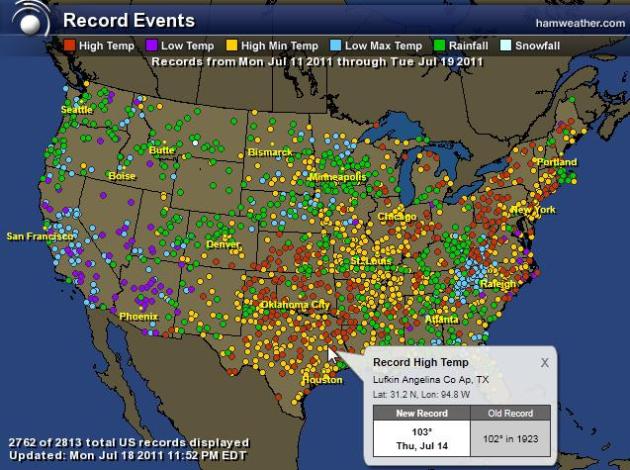
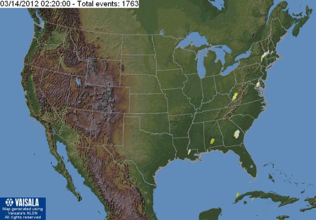
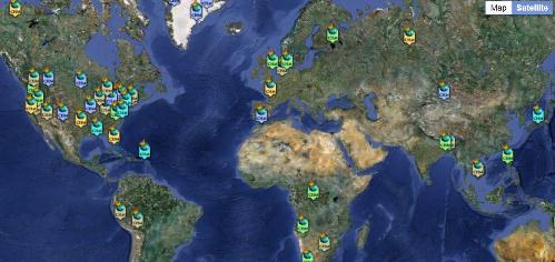
A "Few" Records. O.K. There have been 2813 records since Monday, July 11, mostly record warm daytime highs and nighttime lows. Green dots show record 24-hour rainfall reports, a few low-temperature records for California. Map courtesy of Ham Weather.
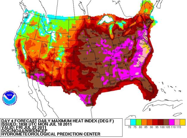
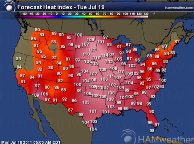
Outlook: Core Of Heatwave Shifts East. By Friday heat indices are forecast to be as high as 110-115+ from the eastern Carolinas to D.C. and Philadelphia - some (slight) relief for the Great Lakes and Upper Midwest. Map courtesy of NOAA NCEP.
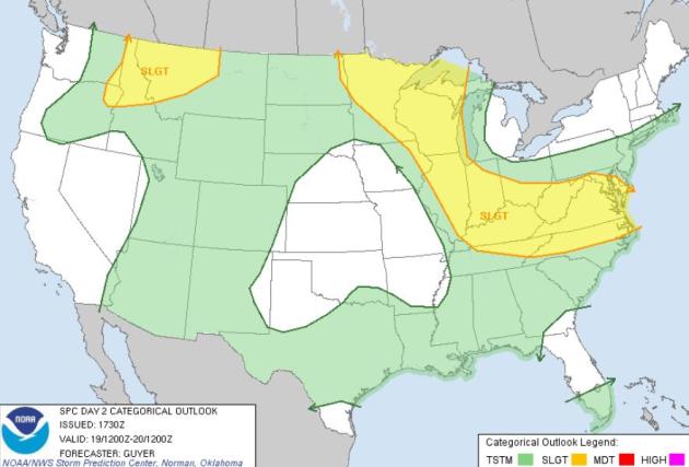
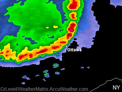
Tuesday Severe Threat. SPC is forecasting a few isolated severe storms from Duluth and the Twin Cities to Madison, Chicago, Louisivlle, eastward to Washington D.C. and Raleigh, a second area of strong/severe storms from Boise to Billings, Montana.
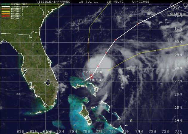
- located 65 miles NNW of Great Abaco Island.
- moving NE at 3 mph.
- min central pressure is 998 mb.
- max winds at 60 mph.
- expecting to turn NNE with a gradual increase in forward speed tonight and into Tuesday
- max winds will likely strengthen later tonight.
- Note: At least 1 named storm has formed during July in Atlantic basin 9 out of the last 11 years (since 2000).
- By the way, we have about a month to go before the meat of the hurricane season arrives. August 15 = Cape Verde season (typically).
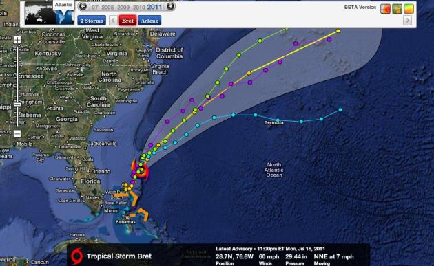
Bret's Track. Almost all the models whisk Tropical Storm Bret into the Atlantic, very little risk of a direct strike along the east coast of the USA. Map courtesy of NHC and Ham Weather.

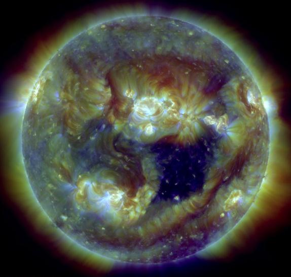
"A dark gap in the sun's atmosphere--a "coronal hole"--is spewing solar wind toward Earth. Estimated time of arrival: July 19th. This morning, UV-filtered telescopes onboard NASA's Solar Dynamics Obervatory photographed the opening. Coronal holes are places where the sun's magnetic field opens up and allows hot gas to escape. A million mile-per-hour stream of solar wind flowing from this hole could spark polar geomagnetic storms when it arrives early next week. High-latitude sky watchers should be prepared for auroras."
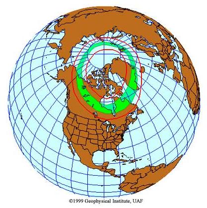
* The result of all this solar activity may be an increased chance of seeing the aurora this week. Keep an eye out. To see where the Aurora Borealis is visible right now click here, courtesy of Alaska's Geophysical Institute.


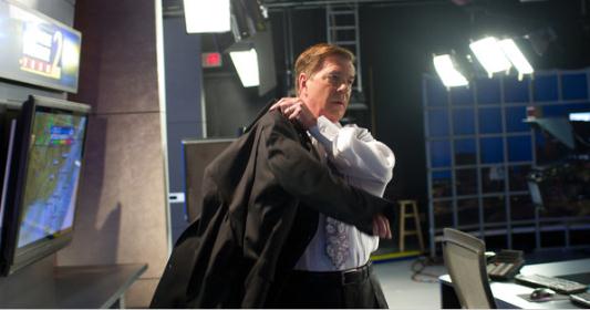
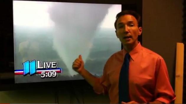
As Weather Becomes The Big Story, TV Forecasters Play The Hero. Yes, TV meteorologists have gotten a workout this year. 2010-2011 may go down in the record books as the 2 most severe years on record, nationwide. The New York Times has the story: "As the nation moves through a year of remarkable floods, drought and its deadliest tornado season in half a century, the broadcast meteorologist has emerged as an unlikely hero. Increasingly, the weather is becoming a bigger part of the national conversation. As scientists explore the implications of climate change and severe weather’s effect on everything from crops to urban infrastructure, broadcast meteorologists like Mr. Burns are the ones who bring it home every day in eye-popping computer graphics. “The weather is more extreme, the floods are wetter and the droughts are drier,” said Chris Vaccaro, a spokesman for the National Weather Service. “That’s going to have real implications on society, and it elevates the need for more information and a need for those on-air personalities. It’s beyond what to wear for the day or do I need to carry an umbrella.” Gone are the days when the local weather guy had to climb on a tricycle at the clown parade, and Diane Sawyer, who got her start delivering forecasts in Louisville, Ky., was called a weather bunny. Now, the forecaster is the egghead of the newsroom. Most have advanced degrees that include courses in calculus and atmospheric thermodynamics."


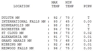
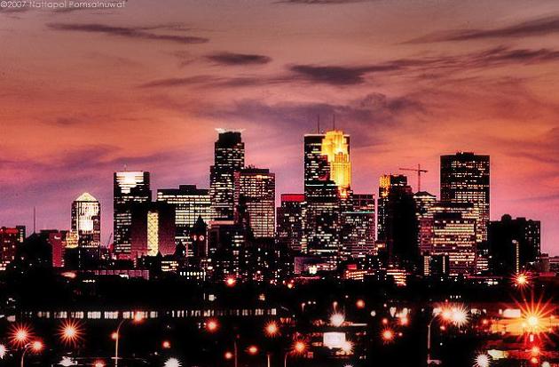
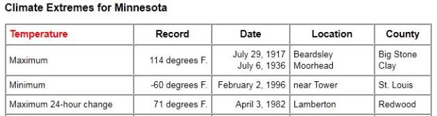
Blazing Sunshine. Yes, it was "hot enough for me". 98 in the Twin Cities, where the "urban heat island" added a few degrees to the air temperature, more asphalt and concrete heating up the metro area. Temperatures ranged from 75 at Grand Marais to 94 at St. Cloud and 96 at Redwood Falls.
Paul's SC Times Outlook for St. Cloud and all of central Minnesota:
TODAY: Excessive Heat Warning. Tropical sunshine, potentially dangerous levels of heat & humidity. Few PM storms, some severe, especially north/east of MSP. Dew point: 79. Winds: S 10. High: 94 (Heat Index: 110-118)
TUESDAY NIGHT: Warm, jungle-like humidity levels. Low: 79
WEDNESDAY: Hottest day? Sunny. Dew point: 74. High: 97. (Heat Index: 115)
THURSDAY: Partly sunny, slight drop in humidity. Dew point: 59. Low: 72. High: 87
FRIDAY: Sunny north, few T-storms south, still humid. Low: 69. High: 88
SATURDAY: Still steamy. Few T-storms around, some potentially strong. Low: 72. High: near 90
SUNDAY: Sunnier day of the weekend, less humidity. Low: 71. High: 88
MONDAY: Partly sunny, still sticky. Low: 67. High: 82
"Humigeddon"
My windows are fogging up & my drip-dries are drooping. The scene outside my window looks like Bangladesh (with pine trees). Welcome to historic levels of water in the air floating over Minnesota.
Sunday evening the Twin Cities tied the all-time dew point record (81). Madison, MN reported a Sunday evening dew point of 86, creating a ghastly heat index of 119. It was so hot in northwest Iowa that smoke alarms went off.
Jungle-like heat and humidity continues into midweek; what will in all probability be the hottest weather of the summer. Upper 90s are possible, 100 can't be ruled out in the metro area Wednesday, where some of that "urban heat island" (more concrete & asphalt) will make it 2-5 degrees hotter than the suburbs.
An area of the USA the size of Mexico (25% of the lower 48 states) are under a heat advisory or warning - a heat index of 115 is possible today and tomorrow. Before you invest in real estate in Anchorage here's some good news: winds shift to the northwest by Thursday; Canadian air dropping temperatures and dew points to more tolerable levels (only 90). T-storms may pop up today, again Saturday.By the weekend you may be praying for a cooling shower.
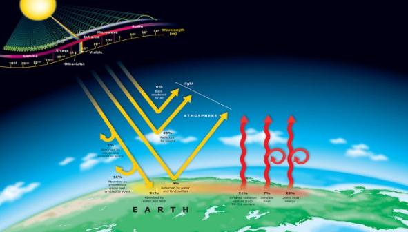
Global Warming, Ice Sheets and Sea Level Rise. Here's an interesting post (with some great resources for further research) from gcaptain.com: "Whales know that ~70% of the surface of the earth is covered in water. Penguins know that about 10%, or six million square miles is covered in ice. For now. Those values will change as the earth continues to warm and the ice sheets melt at an accelerated rate. There are three major repositories of ice left on the earth – the ice sheets of Antarctica and Greenland, and various small mountain glaciers and ice caps. Between Greenland and Antarctica, they contain 99% of the fresh water on our planet. Just how much ice is sitting in Antarctica and Greenland? The answer is staggering. The volume of ice in Antarctica is around 30 million cubic kilometers (7.2 million cubic miles), spread over around 14 million square km, or an area about the same size as the United States and Mexico combined (5.4 million square miles). About 2.2 million cubic kilometers of this ice lies trapped in the West Antarctic Ice Sheet (530,000 cubic miles). It is so massive that is has depressed the rocks on which it lies by around 0.5 to 1 km (Anderson, 1999). Up north, the Greenland ice sheet has a volume of ~2.9 million km3 (695,000 cubic miles)."
Naomi Oreskes: Fierce Defender Of Climate Change Science - And Scientists. Here's an article on a researcher who has painstakingly documented the climate disinformation (and oil-fueled skepticism) going on right now. The complete story is at the Christian Science Monitor: "Postcard after postcard came addressed to Naomi Oreskes after she wrote her first book on how scientists study the movement of continents. A groundswell of attention, perhaps? Not exactly. Her mother wrote them all, dashing off each postcard after finishing a chapter. Outside the worlds of science and academia, the book didn't attract much attention. But 12 years later, the Manhattan-raised historian is traveling a much more public path, drawing both praise and condemnation. She's a fierce defender of scientists and a leader in the vanguard of those who strongly advocate that the world must acknowledge and deal with global warming. "Professor Oreskes has turned vilified scientists into the heroes they deserve to be," says John Abraham, an associate professor at the University of St. Thomas in St. Paul, Minn. She's performing a service regarding global warming by showing "how a few organized and influential people were able to confuse the country long after the science was settled," he says. Oreskes, a professor of history and science studies at the University of California, San Diego, acknowledges that she's trying to save the world. Earlier, though, her goal was simpler. She wanted to understand scientists by studying their past, in terms of both their findings and their funding."

Confessions Of A Climate Change Convert. Some very well-known and outspoken climate critics are now acknowledging the fact their initial skepticism was misplaced. They caught up with the facts and have now come to realize that 97.4% of peer-reviewed climate scientists may be right about climate change. Climate Denial Crock Of The Week has more: "Some of the most passionate advocates for educating the public on climate change are individuals who, after years of climate change skepticism, simply found themselves overwhelmed by the force of the evidence, and had the objectivity and honesty to look reality squarely in the face. Admiral David Titley, the US Navy’s Chief Oceanographer, told a TEDx Pentagon audience his story last year, and I posted the video. More recently, Conservative writer D.R.Tucker wrote a widely noticed piece in the FrumForum, (former George W. Bush assistant) David Frum’s conservative blog, “dedicated to the modernization and renewal of the Republican party and the conservative movement.” Tucker’s piece is reposted below in its entirety, with permission.
I was defeated by facts.
It wasn’t all that long ago when I joined others on the right in dismissing concerns about climate change. It was my firm belief that the science was unsettled, that any movement associated with Al Gore and Van Jones couldn’t possibly be trusted, that environmentalists were simply left-wing, anti-capitalist kooks. It wasn’t until after I read Stanford University professor Morris Fiorina’s book Disconnect (2009) that I started to reconsider things. Fiorina noted that while environmentalism is now considered the domain of the Democratic Party, for many years it was the GOP that was identified with conservationist concerns. I was curious as to how the political climate shifted with regard to environmentalism—and whether there was something to all this talk about climate change."

The heat indexes in Minnesota during the 4PM to 6PM period on Tuesday 19 JULY 2011 appear to have been the hottest on the planet earth at that time.
ReplyDelete