Friday, August 12, 2011

Few PM Pop-Up Showers (Sunday: a meteorological masterpiece)

79 F. high at St. Cloud Friday.


Today: scattered showers (thunder possible). Dew point: 61. Winds: N/NE 10-15. A fairly unsettled day with more clouds than sun. Highs: 69 (up north) -73 (St. Cloud area).

.12" rain predicted today (best chance of a few showers and T-showers this afternoon).

Sunday: nicer day of the weekend with bright sun (no rain expected). Dew point: 57. Winds: S/SE 5-10. Highs: 78-83.
+2.3 F. August is running 3 degrees above average at St. Cloud. The reason: unusually warm nighttime lows. Even though we haven't seen any 90s (yet) in August, nighttime lows since August 1 have averaged close to 61 F. More moisture in the air means the temperature can't fall as much at night.


Over 2,000 Unhealthy Air Alerts So Far In 2011, Nationwide. Details from EPA and NRDC below.

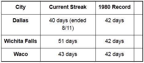
.37" rain fell on Midland, Texas Thursday. That's more rain than fell on Midland the previous 10 months combined!

"...But it was during the July heat wave of 1995 that the highest dew point of all was measured in the Upper Midwest: 90° at Appleton, Wisconsin at 5 p.m. on July 13th of that summer. The air temperature stood at 101° in Appleton at that time leading to a heat index reading of 148°, perhaps the highest such reading ever measured in the United States." - article below from Weather Underground about America's most extreme dew point temperatures.


Fox News "Planet Earth", Brought To You By ExxonMobile. Details below.


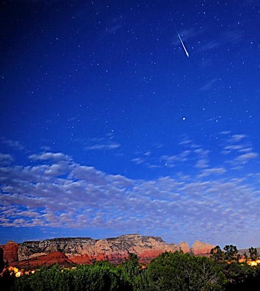
Perseid Meteor Shower. Generally thought to be one of the best of the year, the "Perseids" peaks tonight and Saturday night. Between cloud and a mostly-full moon it may be hard tracking shooting stars, especially around the light pollution of major cities, but it's worth a try. More details from spaceweather.com: "Earth is entering a stream of debris from Comet Swift-Tuttle, source of the annual Perseid meteor shower. International observers are now reporting more than 20 Perseids per hour, a number that will increase as the shower reaches its peak on August 12-13.

Photo credit: (Thursday night) in Arizona, photographer Marsha Adams caught a Perseid meteor shooting over Ship Rock near Sedona.


Perseid-Cam. Here's a live stream of the meteor shower, courtesy of NASA and UStream: "A live video/audio feed of the Perseid shower is embedded here. The camera is mounted at NASA's Marshall Space Flight Center in Huntsville, Ala. During the day, you'll see a dark gray box -- the camera is light-activated and will turn on at dusk each evening. At night you'll see white points, or stars, on a black background. You can also access these links to more all sky cameras to have other views of the sky. Before the camera activates, you can still hear the audio of meteors passing through the sky, creating blips, pings and whistles. The meteors themselves don't make sounds, but they ionize the air around them as they burn up. These ionized air molecules reflect radio waves back to our antenna.  You can also watch throughout the night and see a Perseid fireball composite "grow" as new Perseids are added to a composite image, courtesy of ELP Allsky in El Paso, Texas."
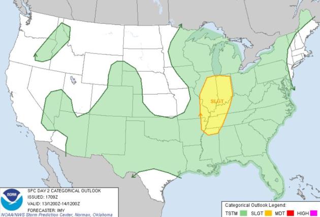


Severe Saturday. A few storms may be severe ahead of an eastbound cool front from the southern suburbs of Chicago southward to Indianapolis, Louisville and Memphis.
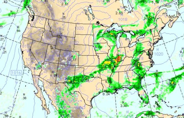

Saturday Weather Map. The latest WRF model shows an almost September-like storm spinning up over southeastern Minnesota - a swirl of showers and T-storms from Minnesota across Wisconsin, southward to St. Louis and the Mid South. More showers and storms stretch from Pittsburgh southward to Charlotte and Savannah, while the western half of the USA stays mostly-dry.
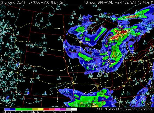

Today: Instability Showers. A pool of cold air aloft will leave the atmosphere over Minnesota and Wisconsin unsettled today, a few hit-or-miss showers (possible thunder) as winds swing around to the north. It won't rain the entire day, but .10 to .20" rain is predicted - best chance during the afternoon and early evening hours.
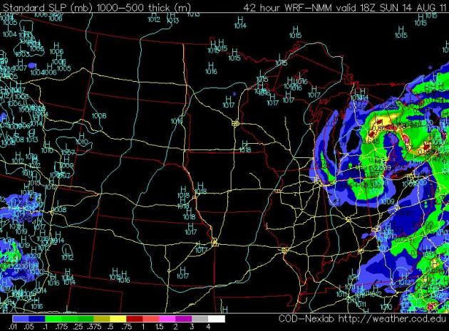

Sunday: Weather Bliss. Tomorrow should restore your faith in a Minnesota August - a bubble of high pressure settling over southern Minnesota, treating us to bright sun, highs within a whisker of 80 with dew points in the 50s and a light south/southeast breeze, under 10 mph. No rain expected Sunday.
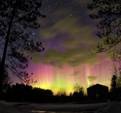
Record Cold This Week Up North. Here's an excerpt from Mark Seeley's WeatherTalk blog: "Following such a hot July and warm start to August who would have guessed we would see some record low temperatures materialize on August 10th (Wed). Northern Minnesota observers reported morning lows in the 30s F on Wednesday this week. Embarrass reported just 36 degrees F on August 10th (but it was not a record for them), while Orr, Bigfork, and Tower reported 39 degrees F. The record-setters occurred at International Falls with 39 degrees F (tied record from 1982), 37 degrees F at Crane Lake (tied record from 1967), and 38 degrees F at Hibbing (new record low)."

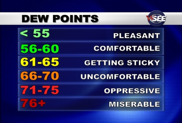
Record Dew Point Temperatures. Christopher C. Burt at Weather Underground has a great post about record dew points around the USA. Here's an excerpt: "Last summer (2010), Newton, Iowa recorded an 88° dew point on July 14th. Chicago, Illinois’s highest dew point was 83° at 8 a.m. on July 30, 1999 as was Milwaukee, Wisconsin’s with an 82° the same day. But it was during the July heat wave of 1995 that the highest dew point of all was measured in the Upper Midwest: 90° at Appleton, Wisconsin at 5 p.m. on July 13th of that summer. The air temperature stood at 101° in Appleton at that time leading to a heat index reading of 148°, perhaps the highest such reading ever measured in the United States."

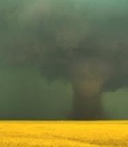
Wood Lake, Nebraska Tornado. You can always count on Severe Studios to be in the right place at the right time. Storm chaser Jeff Gonzales captured some amazing footage of a "white" tornado (the sun was shining on the funnel) near Wood Lake, Nebraska. Details: "SevereStudios chaser Jeff Gonzales shoots video of a nice late-season tornado in northern Nebraska on Thursday, August 11, 2011."


"Death By Ignorance". Veteran meteorologist, research scientist (and part-time tornado chaser) Chuck Doswell, a legend in the field of tornado research, has a few deep thoughts about tornado warnings and why the death toll was so high this year. Here is an excerpt of a post at his blog, "Chuck's Chatter":  "We meteorologists could issue pretty much perfect forecasts and yet people still will die as a result of storms when they hit populated areas. Why is that?  It’s fatalities that justify the cost associated with studying severe storms. Society invests its resources in our research with the hope that increasing our understanding of storms will result in improved forecasts, in turn resulting in reductions of fatalities associated with storms. Perhaps there’s even some hope of mitigating the damage such storms produce, as well. In my examination of storms and the fatalities they produce, I’ve discovered that a significant fraction of storm fatalities arise from ignorance! Not all fatalities, to be sure – there are other factors that cause fatalities: poverty, physical handicaps, age, etc. But I believe the majority of deaths are directly or indirectly related to ignorance. People drive into tornadoes. People drive into rising flood waters. People ignore severe weather warnings. Why? In part, the answer seems to be ignorance, in one way or another.  There are two types of ignorance: the first is simply a lack of knowledge. Everyone has gaps in their knowledge for the simple reason that no one knows everything. But there’s another type of ignorance: willful ignorance. This is when someone has a good reason to know something, because that knowledge could save their lives, but they simply choose not to learn. This willful ignorance has a synonym: stupidity."

Report Details 2,000 "Unhealthy Air" Alerts in 2011. Iimage above courtesy of the EPA. Here are more details, courtesy of EPA and the NRDC, the Natural Resources Defense Council:

"A report from the Natural Resources Defense Council counts more than 2,000 code orange alerts in U.S. communities and national parks from Jan. 1 to early August. One reason for the high numbers may be the extreme heat waves over much of the country. In 1994, another year with lots of heat waves, it "was a notorious example of a bad air year. I'm betting this year will be a notorious year too," he says. It's not surprising that the highest number of code orange days are in California, given the large number of vehicles in the greater Los Angeles area. It also means that smog can spill across the mountains around L.A. into some of the deserts. "We don't expect to find pollution there," Walke says. Some of the numbers included eastern San Bernardino County, with 54 code orange days, Sequoia and Kings Canyon national parks with 44, Joshua Tree National Park with 39 and Atlanta with 28. The numbers are based on early EPA raw data obtained by NRDC."

Missourians Opposed To River-Taming Effort. A comprehensive story from the AP: "The upper river includes roughly 140 levees. Under Plan H, all but about 20 would be raised to protect against a 500-year flood — a flood so severe it would be expected to occur once every half-millennium. The plan has some powerful supporters — the Mississippi River Commission, the Upper Mississippi, Illinois and Missouri River Association (UMIMRA), agricultural and political interests in Illinois. But even the corps refuses to endorse it, citing a low return on investment. Virtually from the time the explorer Hernando De Soto crossed the Mississippi River in 1541, people have been trying to control it. Flooding this year again showed those efforts have drawn mixed results. Crests topped record levels at many places in the lower half of the Mississippi, damaging or destroying thousands of homes and businesses. But the lower Mississippi has provisions that the upper part lacks — specifically designated spillways in southern Missouri and in Louisiana that can be intentionally flooded, helping to reduce water levels and averting catastrophe at some communities. The spillways were utilized this spring."

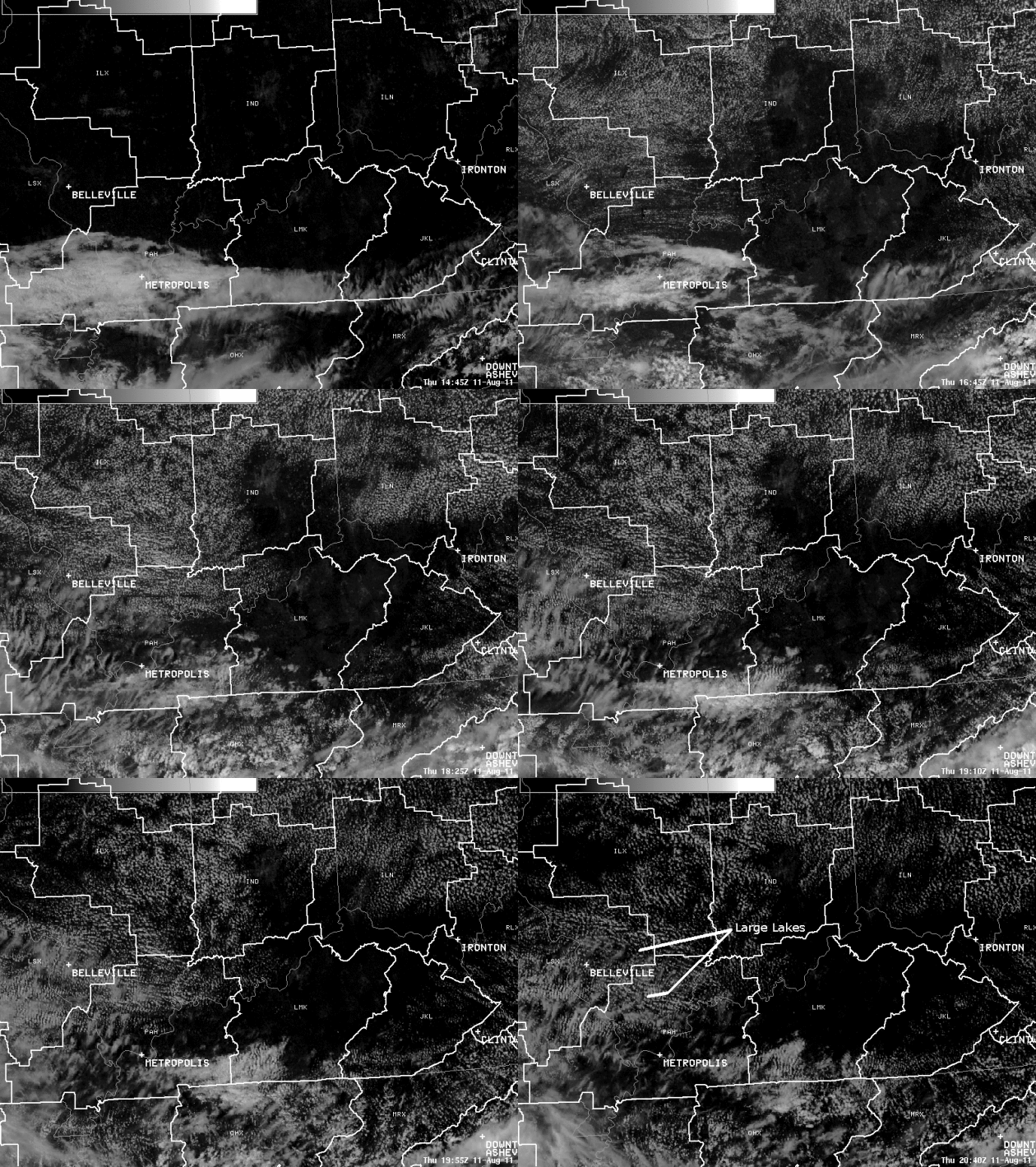
"Reverse Lake Effect". During the summer months lakes are cooler than surrounding land, which tends to inhibit cloud formation. Here's an interesting post (and great visual explanation) from the Central Regional Office of the National Weather Service:

"Thursday afternoon's visible satellite imagery was very cool as two holes in a large area of cumulus clouds persisted over south central Illinois. To understand why these holes appeared, the process of cumulus cloud formation must be understood. Below is a schematic showing the earth's surface and air near the surface being heated by the sun. As the temperature increases rapidly, air parcels begin to rise because they are warmer than their surroundings. If you combine the rising air with enough moisture, clouds are created because the air slowly saturates as it rises and cools. Cumulus clouds are formed! The reason there were no clouds over the large lakes is because water does not heat up as fast as the land does during daytime heating, and therefore air parcels were not rising high enough to create clouds over the lake."
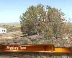


"Mystery Tree" Survives Wildfire - Again. Neatorama.com has the remarkable details - this thing just will not die! "A 20-foot juniper tree near Sunset Point, Arizona survived a wildfire last week that consumed everything around it. It’s not the first time, either. In fact, the tree is a famous survivor. Every year it’s decorated for Christmas and Independence Day. Right now, it’s covered with several American flags and yellow ribbons. It also has its own water system set up underneath, with several large drums and a pipe to feed it water."


For The Plugged-In, Too Many Choices. The New York Times highlights an issue that many of us are facing: how much time to devote to Facebook, Twitter, LinkedIn, and other social media options. You could spend the entire day online stalking friends (and strangers) - and many people seem to do just that. Details of the digital-conundrum: "The relentless pressure to partake of the newest networks was underscored in June with the debut of Google+, Google’s social networking site. According to Nielsen, social networking is now the most popular online activity, ahead of sending e-mails, searching the Internet and playing games. Put another way: one in every four-and-a-half minutes spent on the Web is spent on a social networking site or blog. And last year the average visitor spent 66 percent more time on such sites than in 2009, when early adopters were already feeling digitally fatigued. “I’m on tech overload,” said Ms. Lawrence, who has Facebook and LinkedIn accounts yet barely uses them anymore. “I already feel like I’m experiencing slow death by e-mail.” While she loves technology and has been experimenting with Google+ since it was introduced, “I’m having a really hard time justifying adding yet another social tool to my tool `kit,” she said."(image above courtesy of articulate.com).


Bat On A Plane. If you missed this it's worth a look: somehow a bat got loose on a recent Atlantic Southeast flight. A passenger slammed the bathroom door shut, trapping the bat - and it (apparently) "escaped" by crawling down thru the toilet (yuck!) Video courtesy of the Aviation Herald and CNN: "An Atlantic Southeast Airlines Canadair CRJ-200, flight EV-5121 from Madison,WI to Atlanta,GA (USA), was climbing out of Madison when a bat flew a few rounds through the passenger cabin until a passenger opened the rear lavatory door, the bat explored the inside of the lavatory but then found the door shut again. The crew decided to return to Madison for a safe landing about 10 minutes after departure. The airline reported that a flying animal, unclear whether bird or bat, prompted the return to Madison. The aircraft was searched and subsequently flew to Atlanta. The aircraft reached Atlanta with a delay of 3:45 hours."


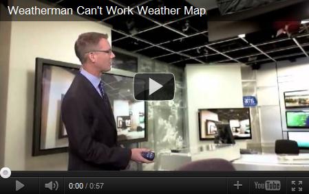
"Damn Clicker!" A few million dollars worth of meteorological hardware, and it all comes down to a souped-up garage door opener (the "clicker" TV meteorologists use to advance their weather graphics systems). A couple of times over the years my clicker wouldn't work (sounds serious). The batteries tend to drain when it gets cold - making the clicker useless (meaning you wind up talking about ONE graphic for 3 minutes). Not good. Once, at KARE-11, I got so frustrated with my crippled clicker that I threw it as far as I could - maybe that's why I'm no longer at KARE-11. Here's a quick blurb about Chuck Bell, a TV meteorologist in Washington D.C., as reported by the Washington Post's Capital Weather Gang. How do you think he handled his "inoperative clicker problem"?
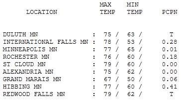

Better-Than-Expected Friday. A wave of storms passes south/west of the metro early Friday morning, and then the sun came out - treating us to a fairly nice Friday. More storms rumbled into western Minnesota by evening, but by that time the atmosphere wasn't unstable enough for anything severe. Highs ranged from 67 at Grand Marais to 77 in the Twin Cities, 79 at St. Cloud, where the sun was out for a couple of extra hours.


photo courtesy of "Bent Objects".


Paul's SC Times Outlook for St. Cloud and all of central Minnesota:


TODAY: More clouds than sun, breezy and unsettled with a few pop-up showers this afternoon. A stray T-shower can't be ruled out.. Dew point: 62. Winds: N/NE 10-15. High: 73

SATURDAY NIGHT: Showers taper, partial clearing late. Risk of a meteor shower. Low: 55

SUNDAY: Much better. Low humidity with bright sunshine. Dew point: 56. Winds: NE 5-10. High: 80

MONDAY: Partly sunny, still dry. Dew point: 57. Low: 62. High: 81

TUESDAY: Few strong storms up north. Low: 64. High: 82

WEDNESDAY: Unsettled, another shower or 2 possible. Low: 67. High: 80

THURSDAY: High pressure = blue skies. Dew point: 58. Low: 62. High: 81

FRIDAY: Partly sunny, more humid. Dew point: 66. Low: 63. High: 82


Hints of Autumn

A perfect summer day is when the sun is shining, the breeze is blowing, the birds are singing, and the lawn mower is broken" wrote James Dent. My (endless) honey-do list is on hold. Too windy, too damp, too showery & cool. I am so sorry.

Today is a bit of a meteorological disappointment; not as nice as I had hoped a few days ago. The perils of a 7-Day Outlook. It turns out today's cool front is tracking slower than previously predicted. "Backlash", moisture wrapping completely around an area of low pressure, coupled with cold, unstable air aloft, will keep the Doppler freckled with rain showers - highs stuck in the 60s and low 70s. Vague whispers of September in the air, but too cool & stable for anything severe.

Get your indoor-stuff done today; Sunday should renew your faith in a Minnesota August. High pressure will coax a blue sky, with less wind and highs near 80.

If anyone asks (doubtful) - August is running 2.3 degrees warmer than average at St. Cloud. No 90s, but nights have been unusually warm. More moisture in the air limits how far the mercury can drop each night - a trend we're witnessing over much of the northern USA. Have a great weekend. Enjoy tomorrow!


* photo above courtesy of thisisjuststupid.com.

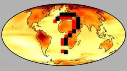
Polar Climate Change May Lead To Ecological Change. Here's an excerpt of a story at eurekaalert.org: "Ice and frozen ground at the North and South Poles are affected by climate change induced warming, but the consequences of thawing at each pole differ due to the geography and geology, according to a Penn State hydrologist. "The polar regions, particularly the Arctic, are warming faster than the rest of the world," Michael N. Gooseff, associate professor of civil and environmental engineering, told attendees today (Aug. 11) at the 96th annual meeting of the Ecological Society of America in Austin, Texas. "As a consequence, polar ecosystems respond directly to changes in the earth systems at the poles." These changes, though different at each pole, could be significant in their effects on not only the local environment, but also globally. While the central part of the Arctic is composed of ice over water, northern Canada, Alaska, Siberia and Greenland all have landmasses within the Arctic Circle. The associated land and water ecosystems are affected by melting ice and thawing soils, but in Antarctica, where much of the ice overlays a continent, the warming alters streams, lakes and the tiny plants and animals that live there. "Our focus on the north is in part because it is inhabited, but it is also because the ice there is more vulnerable," said Gooseff. "Temperatures and snow and rain across the tundra shifts annually and seasonally. We know that fall is beginning later than it once did." In the Arctic, where there is more immediate feedback from the higher temperatures, the warming is degrading permafrost, the layer of the ground that usually remains frozen during annual thawing events. This causes creation of a boggy, uneven landscape with a disturbed surface. Subsequent rain or snowmelt can erode this surface carrying silt and sediment into bodies of water, changing the paths of rivers and streams. Debris flows are also a common occurrence in degraded permafrost areas."


At Fox News, "Planet Earth" Is Sponsored By ExxonMobil. Here's a post from Media Matters: "We noted in June that Fox News' iPad app was sponsored exclusively by ExxonMobil, a corporation known for paying think tanks to obfuscate the scientific consensus on climate change. Now FoxNews.com's "Planet Earth" section is also brought to you by the oil giant: In fact, FoxNews.com's entire Science & Technology section and their opinion page appear to be sponsored by ExxonMobil; the other sections of their website are not. Earlier this year, FoxNews.com sought to debunk the fact that Earth has warmed over the past 30 years, as well as the notion that human activity has contributed to the warming with a "Planet Earth" article,  portions of which "are utter nonsense" and "do not make sense" according to climatologists consulted by Media Matters. Two recent stories that Fox News' Planet Earth section ran on climate change were based around claims pushed by the Heartland Institute's James Taylor and quoted Taylor's views. A post by Taylor, which baselessly claimed a research group "doctors sea level data" to exaggerate climate change, inspired a FoxNews.com article asking, "Is climate change raising sea levels, as Al Gore has argued -- or are climate scientists doctoring the data?"

No comments:

Post a Comment