Say What?
We've been having a lot of (say what?) moments
in recent years. 145 tornadoes in Minnesota in 2010, most in the USA.
Four 1,000-year flash floods since 2004. Plowable snows in early May?
Longer growing seasons. Higher dew points, warmer temperatures at night.
It's a long list.
And now comes a hiccup of chilly air for Friday & Saturday, an airmass you'd expect to see in late September.
Huh?
In spite of blue sky temperatures may hold in
the 60s across much of Minnesota by Friday; Saturday morning's forecast
includes a risk of a sweatshirt or two - with an outbreak 40s up north.
Unusual, considering that, historically, we're just coming out of the
hottest weeks of the year. Expect the unexpected right?
The approach of this unusually vigorous Canadian
cool front sets off smear of T-storms later today; a tiny percentage
may turn severe with large hail and strong straight-line winds. A stiff
northwest wind kicks up a few whitecaps on your favorite lake Friday. By
early Saturday your furnace may kick on.
Sunday looks milder with less wind (and fewer
July goosebumps). The worst of the heat & humidity passes just south
of home next week.
Remind me not to take 80s for granted.
* image above: Environment America.
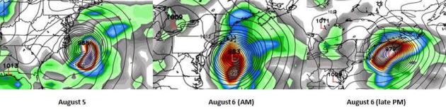
GFS "Guess-Cast". Yes, it's borderline irresponsible
even sharing this with you, but under the heading of full
disclosure: here is the GFS 288-324 hour forecast, showing a very close
encounter between (Hurricane) Dorian and the East Coast of the USA. This
solution shows a near-miss for the Outer Banks of North Carolina and
New England, with a potentially significant storm surge - but the brunt
of the highest seas, heaviest rains and strongest winds remaining
offshore. Confidence levels are very low right now. We'll be tracking
the models to see if there is alignment over time, but right now it's
still too early to know whether Dorian will impact the USA. More details
on Tropical Storm Dorian below.
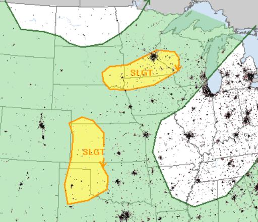
Thursday Severe Threat. A southbound cool front (of
unusual intensity for late July) may spark a few severe storms later
today over the southern third of Minnesota. SPC has another "slight
risk" from western Kansas into the Panhandle of Texas. The major
concerns: large hail and straight-line winds.
Cool Bias Continues. I still don't see any signs of
hideous heat and humidity returning to MSP anytime soon. ECMWF
(European) guidance above shows highs near 70 Friday, low 70s Saturday,
mid 70s on Sunday, with highs approaching 80F early next week. The best
chance of T-storms: today, again Monday and Tuesday of next week.
Canadian Leakage. Sounds like a terrible medical
condition. A surge of unusually cool air (for late July) sparks strong
to severe T-storms over the Upper Midwest, cooler air reaching New
England by the weekend. Meanwhile a tight, intense storm tracks up the
East Coast, pushing potentially heavy rain into New England by Friday.
Spotty T-storms sprout over the Rockies and Southwest. 84 hour NAM
model: NOAA.
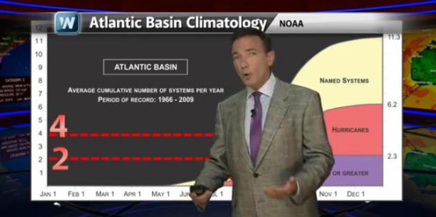
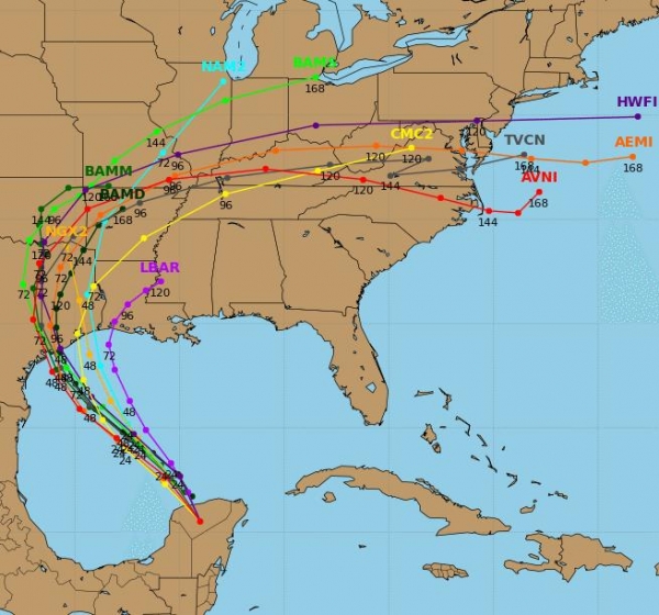
Tracking Dorian. Short-term, the models aren't all
that impressed with Tropical Storm Dorian. But history shows that it's
the tropical systems that form earlier in the season which often spawn
the most problems (the A-K storms are most likely to be so severe NHC
"retires" the names). In today's edition of
Climate Matters we take a closer look at Dorian, and implications for the USA: "
It's
July 24th and we're already talking about the 4th named Atlantic storm
of the season. That's about a month ahead of schedule. WeatherNation
Chief Meteorologist Paul Douglas looks at Dorian's projected path,
potential to gain strength, plus what makes this storm so unusual for
this time of year."
From
Alerts Broadcaster, issued on Wednesday:
What we're monitoring:
* "Dorian" has now reached Tropical Storm status, with
sustained winds of 50 mph. Conditions are ripe for (minor) strengthening
in the days to come. Hurricane strength may be reached within 48 hours.
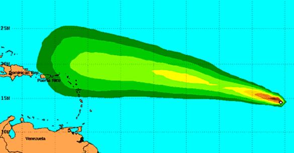
* Dorian should track north of the Lesser Antilles,
possibly brushing The U.S. Virgin Islands and Puerto Rico by Monday of
next week.
* It's still (very) early to contemplate final track and intensity, but Dorian poses some risk to Florida and the coastal Southeast USA the first half of next week.
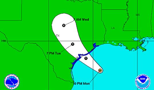
Projected Path.
Dorian is expected to track in a west-northwesterly direction over the
next5 days, passing just north of San Juan Puerto Rico by Monday of next
week. Models do not show rapid intensification, in fact many of the
computer simulations keep Dorian at tropical storm strength through the
period.
Timing Dorian.
This new tropical storm (1 in 3 chance of reaching Category 1 strength)
is expected to pass just north of the Lesser Antilles Sunday, heavy
rain and a 2-3 foot storm surge brushing The U.S. Virgin Islands and
possibly the north shore of Puerto Rico Sunday into Monday.
Longer-Term Track.
Confidence level is low to moderate (4 on a scale of 1 to 10) that
Dorian may push into The Bahamas by Tuesday of next week, posing some
risk to the east coast of Florida and coastal Georgia and the Carolinas.
It's still premature to predict if/when Dorian might impact the United
States. We're examing the models, looking for consistency from run to
run and model to model. Interests in the Southeast USA should stay
alert; it looks like less than a 5-10% probability of Dorian pushing
into the Gulf of Mexico.
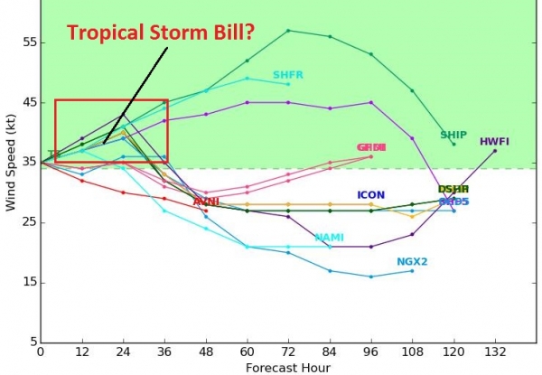
Intensity Forecast.
Due to wind shear in the vicinity of the storm many of the models keep
Dorian at Tropical Storm strength through the weekend; roughly a third
of the models show a Category 1 hurricane within 36 hours. We'll
continue to monitor the storm and model trends and update as conditions
warrant.
Summary: Dorian is
now a Tropical Storm, one that poses some risk to The U.S. Virgin
Islands and Puerto Rico in a Sunday-Monday timeframe. The longer-term
track is still very much up the air, but people living in the Southeast
should stay alert and stay tuned for updates. Any direct impact to the
U.S., from Florida to North Carolina, would probably come
Tuesday-Thursday of next week
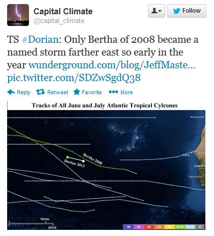
More On Tropical Storm Dorian. My friends at
The Capital Weather Gang (Washington Post) have more details on Dorian that you may find interesting; here's a clip: "
The
average formation date of the fourth named storm over the past fifty
years is August 23rd, so Dorian was born about a month ahead of
average. But in 2012, the ‘D’ storm, Debby, formed two months ahead of
average (on June 23). This storm is also notable for how far east it
formed (29.9 W longitude). Since 1851, I could only find one other
storm that got named so far east so early in the season: Bertha, in
2008, became a tropical storm at 24 W longitude on July 3..."
Forecast For Dorian. Here's an excerpt of a recent post from meteorologist Jeff Masters at the always-fascinating
Weather Underground: "...
Dorian
should maintain a west-northwest track through the week, and spread
heavy rains and gusty winds to the northern Lesser Antilles Islands
beginning on Sunday. The usually reliable European model (ECMWF) has
Dorian passing several hundred miles to the north of the Lesser
Antilles Islands, while the other models show Dorian passing closer,
within 100 miles. It currently appears that Dorian will be a potential
threat to the Bahama Islands, Bermuda, and the U.S. East Coast next
week. There will be a trough of low pressure capable of recurving
Dorian out to sea before the storm reaches the Bahamas and U.S., but
this trough is currently depicted as being fairly weak, reducing the
chances of Dorian missing the Bahamas and U.S. East Coast..."
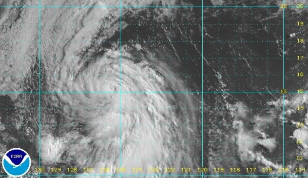
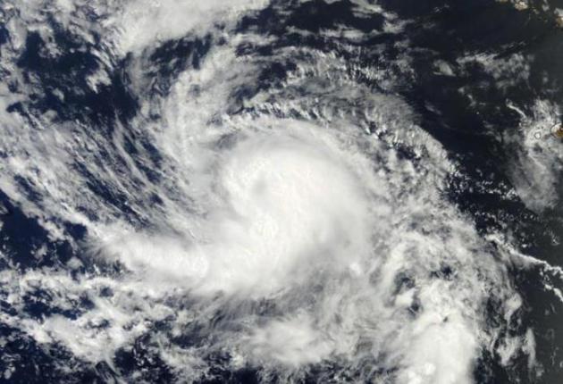
Image credit above: "MODIS
satellite image of Tropical Storm Dorian taken at approximately 8 am
EDT July 24, 2013. At the time, Dorian had top winds near 50 mph." Image credit: NASA.
Why Does NOAA Name Hurricanes? I found this nugget interesting, courtesy of
NHC: "
Experience
shows that the use of short, distinctive names in written as well as
spoken communications is quicker and less subject to error than the
older, more cumbersome latitude-longitude identification methods. These
advantages are especially important in exchanging detailed storm
information between hundreds of widely scattered stations, coastal
bases, and ships at sea. The use of easily remembered names greatly
reduces confusion when two or more tropical storms occur at the same
time. For example, one hurricane can be moving slowly westward in the
Gulf of Mexico, while at exactly the same time another hurricane can be
moving rapidly northward along the Atlantic coast. In the past,
confusion and false rumors have arisen when storm advisories broadcast
from radio stations were mistaken for warnings concerning an entirely
different storm located hundreds of miles away."(Image credit above: NASA).
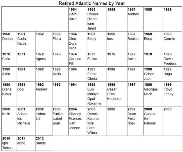
Retired Hurricane Names. Only the storms that lead to significant destruction and loss of life are "retired", names never to be used again.
By
my calculations 76 hurricane names have been retired so far. 61 of the
retired names were A thru K in the alphabet, only 15 names from K-Z.
The storms in the first half of the hurricane season have a greater
probability of being severe enough to be retired, which is vaguely
interesting, at least to me. Of course there are no hurricanes that
start with the letter Q, X or Z. Source:
NOAA NHC.
Did The Clean Air Act Unleash Atlantic Hurricanes?
The air is cleaner than it was in the 60s and 70s, which is great news.
But by reducing sulfate aerosols (which has a cooling effect) and
cleaning up the air - warming of sea surface temperatures may have
contributed to more numerous/intense hurricanes in the Atlantic. Here's
an excerpt of a thought-provoking article at The Washington Post's
Capital Weather Gang: "...
But
a consequence of the SO2 reductions is the simultaneous drop in the
concentrations of sulfate particles or aerosols, which form in the
atmosphere through chemical reactions after SO2 is emitted. Sulfate
aerosols, while pollutants themselves and unhealthy to breathe, have an
atmospheric cooling effect, as the particles are white and highly
reflective. The sun’s energy bounces off of them, rather than heating
the atmosphere and the Earth’s surface. For hurricanes, heat is fuel.
And if you rob them of this fuel, all other things being equal, they do
not grow as intense. Hurricane activity was depressed from the 1960s
to 1980s, when both the concentrations of these sulfate aerosols in the
U.S. were highest and sea surface temperatures were relatively low...."
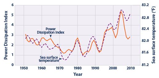
Graphic credit above:
EPA. "
This
figure presents annual values of the Power Dissipation Index (PDI).
Tropical North Atlantic sea surface temperature trends are provided for
reference. Note that sea surface temperature is measured in different
units, but the values have been plotted alongside the PDI to show how
they compare. The lines have been smoothed using a five-year weighted
average, plotted at the middle year. The most recent average (2007–2011)
is plotted at 2009." Here's more information on PDI, Power Dissipation Index, from
NOAA GFDL: "
PDI
is an aggregate measure of Atlantic hurricane activity, combining
frequency, intensity, and duration of hurricanes in a single index. Both
Atlantic SSTs and PDI have risen sharply since the 1970s, and there is
some evidence that PDI levels in recent years are higher than in the
previous active Atlantic hurricane era in the 1950s and 60s."
Houses Of The Rising Sun: Developers Build Homes That Make More Energy Than They Take.
Imagine getting paid by Xcel Energy for putting excess electricity onto
the grid? Some Minnesotans are doing just that. It requires more
investment up-front, but the pay-back can be fairly rapid and
considerable. Here's the intro to a story from AP and
The Washington Post: "
Homes
being built in this Hudson Valley cul-de-sac offer prospective buyers
wooded lots, pretty views and — oh yes — the promise of thumbing your
nose at the power utility. These “zero-net energy” homes will feature
thick walls, solar panels and geothermal heating and cooling systems,
meaning families should be able to generate more energy over a year
than they consume. These homes under construction 70 miles north of New
York City have costly green features. But the builders believe they
are in tune with consumers increasingly concerned about the environment
and fuel costs. And there are homebuyers here and around the nation who
are willing to pay more for savings down the line..."
Photo credit above: Mike Groll - Associated Press. "
A
worker works on the roof of a zero net energy home at The Preserve at
Mountain Vista on Tuesday, July 9, 2013, in New Paltz, N.Y."
You Can Live Forever. Why can't I grow a beard like
this? It would cover up at least 6 states when I turn sideways in front
of my green-screen, but I'm sure viewers wouldn't care. And I'm not sure
I want to live forever, come to think of it, at least not pay bills
forever. Talk about the definition of hell. But if you're interested in
extending your life expectancy you might want to check out this story
from
The Daily Beast; here's an excerpt: "...
Questions
about the future of aging have been in the air lately. Are humans on
the cusp of living to 120, 130, or more? What will aging look like in
this new world of longevity? Will we just be adding 30, 40, 50 years to
the end of life, or can we delay the process and lead normal lives to
such advanced ages? Is 100 the new 60? In 2012, the John Templeton
Foundation awarded UC-Riverside philosopher John Martin Fischer $5
million to study immortality, and in May, Fischer announced that nearly
half of that money would be going to 10 scientific research teams from
the United States and Europe. Earlier this year, Prudential Insurance
Company launched a new ad campaign centered on a simple prediction:
“The First Person to Live to 150 Is Alive Today...”
Photo credit: Peter Searle, Camera Press/Redux. "
De Grey’s research at Cambridge led him to believe we can cure aging—not just stop it or slow it."
Study: 23 and 69 Are The Happiest Ages. Well this gives me something to look forward to.
Time Magazine has the details; here's the intro: "
Just when you thought 33 was the new 20,
a recent study indicates that the ages at which we’re most satisfied
are in fact 23 and 69, giving us not one but two stages of life to
relish. The study that identified those two pinnacle satisfaction
periods, conducted by the Center for Economic Performance at the London
School of Economics, involved a massive number of participants: 23,161
people, ranging in age from 17 to 85, reports Daily Mail..." (Photo image above:
Life Matters).
Guess The World's Most Expensive City? You'll never
get this one - it's not in the USA, Europe or even China. If you were to
guess Moscow you'd be close (that city came in #2 on the list). Here's
an excerpt from
zerohedge.com: "
While Edward Snowden can perhaps breathe a sigh of relief
at being abale to avoid the humdrum beat of airport food for a while,
he will be stepping out into the 2nd most expensive city in the world.
Based on a survey of over 200 items, Moscow ranks 2nd in the world (with $8 cups of coffee and $4,600 average apartment rental costs), and Tokyo 3rd
(with $5 newspapers and $7 coffees). But the most expensive city in
the world will come as a surprise to most and likely create the need
for a Google Maps search. With 40.5% of the population of this nation
living in property and the average monthly rent a sky-high $6,500, this southern African country's capital is the most expensive city in the world
(it would seem the Chinese arrival in resource-rich African nations -
N'Djamena, Chad is 4th - has had its hot-money inflationary effects)."
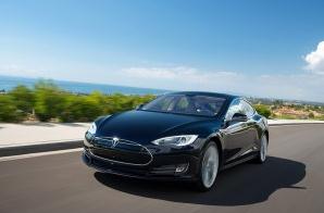
Should GM Lose Sleep Over Tesla? The new Model S is a work of art, a promise of carbon-free vehicles to come that combine utility with style.
Triple Pundit has the story; here's the introduction: "
Should
GM fret at the thought of Tesla? The Big 3 automakers had sneered at
electric vehicles (EVs) for years, but a slow shift is underway. Ford has its plug-ins with the Fusion Energi and C-MAX Energi; Chrysler, thanks to Fiat, has a little toe in the EV waters with the 500e on California roads; and GM touts the Volt and Spark EV. Speaking of GM, the stodgy automaker may be slowly changing its ways: CEO Dan Akerson told Bloomberg in an interview last week the company is taking a close look at Tesla Motors to gauge how the Silicon Valley upstart could eventually threaten GM’s business..."
The Biggest Opportunity On Mobile Right Now Isn't On Smartphones. This story at
Quartz made me do a double-take; here' an excerpt: "
Facebook
has noticed something that other companies would do well to heed: The
biggest opportunity right now isn’t in smartphones, where users are
bombarded by the fruits of an ever-more-competitive market for apps
and mobile services. Rather, the big play for some companies,
especially any that wish to expand into emerging markets, is on the
“dumbphones”—aka non-smartphones, or in industry parlance, feature
phones—that most people in rich countries have now left behind. We’ve
known for some time that Facebook’s strategy for grabbing its “next billion” users
is to convince them that Facebook and the web are one and the same by
making access to Facebook free on every model of phone. But now Javi
Olivan, head of “growth and analytics” at Facebook has dribbled out a handful of other interesting details about Facebook’s strategy..."
Photo credit: "
Facebook's Sheryl Sandberg is looming large in emerging markets." AP/Shizuo Kambayashi
79 F. high on Wednesday in St. Cloud.
82 F. average high on July 24.
82 F. high on July 24, 2012.
.01" of rain fell yesterday at KSTC.
TODAY: Some sun, unsettled and more humid. A few
T-storms, some strong, possibly severe. Dew point: 65. Winds: SW 10-15.
High: 78
THURSDAY NIGHT: Evening shower, possible thunder, then clearing skies, turning windy and cooler. Low: 53
FRIDAY: Windy & cooler with more clouds than
sun. PM shower north. Winds: NW 10-20+ High: 67 (holding in the low to
mid 60s over most of Minnesota).
SATURDAY: Cool sun, hints of late September. Dew point: 50. Winds: NW 10. Wake-up: 48. High: 71
SUNDAY: Cool start. Plenty of sun, the better lake day. Wake-up: 49. High: 75
MONDAY: Partly sunny, T-showers at night. Wake-up: 54. High: 78
TUESDAY: Passing shower, T-shower. Wake-up: 57. High: near80
WEDNESDAY: Warm sun returns, still summer. Wake-up: 60. High: 81
Climate Stories...
Excerpt of a post from Gareth Renowden at Hot Topic, details below.
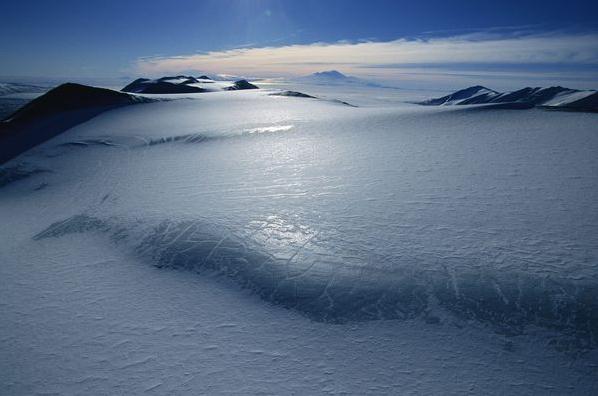
Ancient Global Warming Raised Sea Levels Nearly 70 Feet.
National Geographic has the story - here's the introduction: "
About
five million years ago, sea levels rose by up to 70 feet (20 meters)
as ice sheets in the South Pole began melting during past instances of global warming.
Scientists have now concluded that about half of that sea-level rise
was due to the thawing of a single, enormous ice sheet in East
Antarctica that was once considered stable. "We estimate from our study
that the East Antarctic ice sheet contributed about 10 meters [33 feet]
of sea-level rise," said Carys Cook, a geochemist at Imperial College London in the U.K. and the first author of a new study that details the finding..."
Photo credit above: "
The empty and ice covered land of east Antarctica stretches for hundreds of miles." Photograph by Maria Stenzel, National Geographic Stock.
Antarctic Melted In The Past, And As The Climate Warms, It's Poised To Melt Again. Details in this clip from a story at
Time Magazine: "
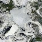
When it comes to polar melting, the Arctic hogs all the attention. And not without reason—last summer Arctic sea ice melted to its smallest extent on record, 49% below the 1979-2000 average. During the first two weeks of July, sea ice declined 61% faster than the 1981-2000 average, according to the National Snow and Ice Data Center. As sea ice melted, Arctic shipping set a record, with trips quadrupling in 2013 from the year before. The Arctic permafrost—the frozen soil that covers much of the tundra—is melting, which threatens the release of vast amounts of the greenhouse gas methane. Thanks largely to climate change, the Arctic is changing before our very eyes..."
Thanks To Global Warming, Arctic Shipping Has Quadrupled In The Last Year. Great news for shippers and the world's consumers huh? Maybe not. Here's an excerpt from
Slate: "
For
years people have been speculating that the melting of Arctic sea ice
due to climate change would open new shipping lanes. In fact, it’s
happening now. The Financial Times reports that, as of Friday, 204 ships had received permits this year to ply the Northern Sea Route,
which connects East Asia to Europe via the waters off of Russia’s
northern coast. Last year, just 46 vessels made the trip. Two years ago,
the number was four. For now, the route remains more treacherous than
the traditional Asia-Europe passage via the Suez Canal. But as Arctic sea ice continues to recede,
it will become increasingly viable during the summer months—especially
since, as the map at right shows, it’s a much shorter route..."
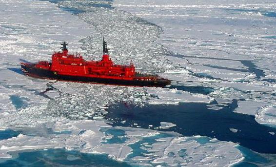
Photo credit above: "
A nuclear icebreaker on its way to the North Pole in 2001." Wofratz /
Wikimedia Commons
Arctic Sea Ice Time Bomb Ticking: The Bang's Gonna Be Huge. Here's a clip from New Zealand's
Hot Topic: "...
In
other words, losing Arctic sea ice brings huge warming to the lands
around the Arctic Ocean. This is extremely bad news for a number of
reasons:
- We’re losing the Arctic sea ice well ahead of any schedule
derived from model predictions. The sea ice summer minimum could drop
below 1 million km2 within a decade. I have argued that it might be even sooner…
- Arctic warming and sea ice losses are already impacting northern hemisphere weather patterns.
- Once the summer sea ice has gone, it’s only a question of
how long it will take for the winter ice to disappear. When I last
looked at this issue, three years ago, I suggested this might happen much sooner than anyone expected — perhaps by the 2040s.
- When I wrote that post, I suggested that — if we were
unlucky — winter ice loss could be within the current climate
commitment — that is, within the warming we would expect to see from
current levels of greenhouse gases. Ballantyne et al’s new paper
explicitly supports that view..."
Climate Change And The Church. Here's a snippet of a guest Op-Ed from a Unitarian minister at
Huffington Post: "...
So
where is the parish church in all of this? Mostly silent, it seems.
Churches continue to be concerned with individual sin as opposed to
systemic sin, even in regard to climate change. Congregants may be
admonished to recycle and change their light bulbs, but not to become
politically active. The fact is we're way beyond changing our light
bulbs. We need to bring that unhappy, startling truth to the pulpits of
our land. If there's any issue we could come together on, it seems this
would be the one, for our actions will determine the future of the
earth and the fate of our children and that of our children's children.
Churches are not allowed to support individual candidates, lest we
lose our tax-exempt status. But we can and must address moral issues,
and there is no greater moral issue facing us than climate change.
There never has been, and there never will be..." (Photo credit:
Longleaf Church).
Climate Change Outruns Evolution, Study Finds. Here's an excerpt from a story at
The Bellingham Herald: "...
Published
online in the journal Ecology Letters, the study concludes that most
land-based vertebrate species evolve too slowly to adjust to the
dramatically warmer climate expected by 2100. If they can't make
high-speed adaptations or move to a new ecosystem, many terrestrial
animal species will cease to exist, the researchers report. "Every
species has a climatic niche which is the set of temperature and
precipitation conditions in the area where it lives and where it can
survive," co-author and University of Arizona ecologist John Wiens says
in a press release. "We found that on average, species usually adapt
to different climatic conditions at a rate of only about 1 degree
Celsius per million years. But if global temperatures are going to rise
by about 4 degrees over the next hundred years, as predicted by the
Intergovernmental Panel of Climate Change, that is where you get a huge
difference in rates..."
Louisiana Flood Board To Sue Oil Companies Over Erosion. Here's an update from
The Miami Herald: "
A
New Orleans area levee authority says it plans to sue dozens of oil,
gas and pipeline companies for their alleged roles in the loss of
coastal lands that serve as a natural buffer against hurricanes. The
Southeast Louisiana Flood Protection Authority-East's board of
commissioners has scheduled a Wednesday news conference about the
litigation it plans to file in New Orleans. The authority, which bears
many of the costs of protecting the region from floods, claims
Louisiana has lost hundreds of thousands of acres of protective coastal
land because of drilling and dredging for canals and pipelines..."


No comments:
Post a Comment