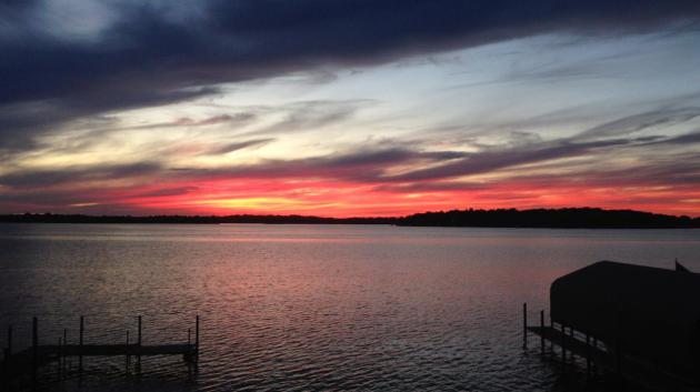
Fast-Forward pattern
Weather,
by definition, is changeable - often extreme. But are natural swings in
temperature and moisture accelerating? Is it our imagination, or are
changes happening faster than they did 30 years ago?
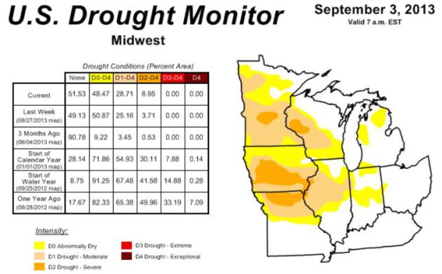
According to
The National Drought Mitigation Center Minnesota saw America's most
rapid onset of drought in August: from 1.7 percent moderate drought on
August 6 to 55 percent by August 26. In a meteorological blink of an
eye.
Sudden 20-30F "heat spikes" in the span of 24 hours in
mid-May, again early this week; a rare August frost up north.
Head-scratching weather.
Farmers are understandably anxious about a
deepening "flash drought"; the rate at which fields are drying out. We
need 3 to 6 inches of rain to replenish dusty topsoil.
That won't
happen anytime soon. Canadian air leaking south will keep us cool,
comfortable and dry into Sunday. Dig a light jacket out of cold storage:
40s at the bus stop Friday, again Monday? A surge of much warmer air
returns next week - more 80s the latter half of the week as dew points
reach the muggy 60s. A scuffle between lingering summer heat &
Canadian chill may increase the potential for rain the last week of
September. I hope that's not wishful thinking.
Jackets
and shorts, together in one closet? More whiplash.
* CEI,
Climate Extreme Index, above shows the percentage of the USA in severe drought or flood from year to year, courtesy of NOAA NCDC.
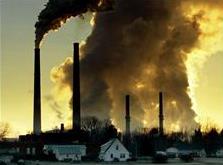
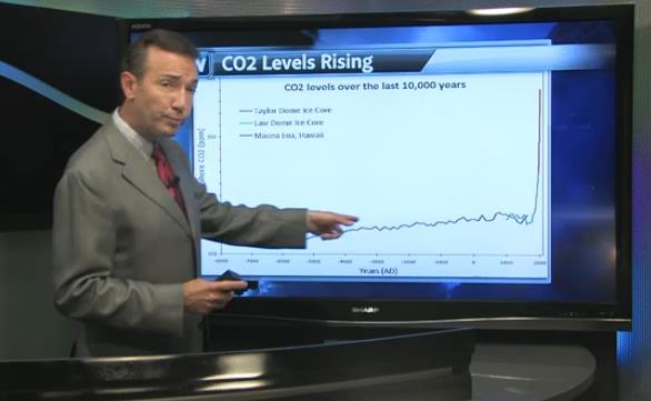
Weather And Climate Volatility Coincides With Fastest Rise In CO2 Ever Observed.
I've been tracking weather for 40 years, and I can't say I've ever
witnessed more abrupt changes in the pattern, the SPEED at which we go
from drought to flood, back to drought again. Whiplash. In today's
Climate Matters
I include a 10,000 year graph of CO2 emissions, which for have held at
180-280 ppm. Carbon dioxide has spiked to 400 ppm, and nobody really
knows how high those levels will rise. It's not only the absolute value,
which is troubling enough, it's the RATE of CO2 and methane rise. This
is what scientists are most concerned about - there is no history, no
analog of a similar spike in CO2 levels, going back hundreds of millions
of years, so I guess we shouldn't be too surprised when the weather
takes a turn for the bizarre: "
Much of the Upper Midwest could use a
good soaking. Hard to believe when we started July, most of the Midwest
was drought free. WeatherNation Chief Meteorologist Paul Douglas says
in 35 years in the weather business, he's never seen such sudden
changes. Hence the term: "Flash Drought".
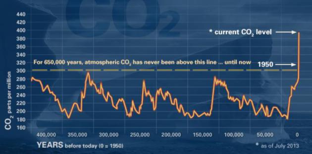
400,000 Years Of CO2 Records.
Using ice core samples (Greenland and Antarctica) it's possible to
reconstruct the concentration of carbon dioxide in the atmosphere.
According to
NASA for 650,000 years atmospheric CO2 has never risen above 295 ppm. Until recently - now the level stands at 400 ppm.
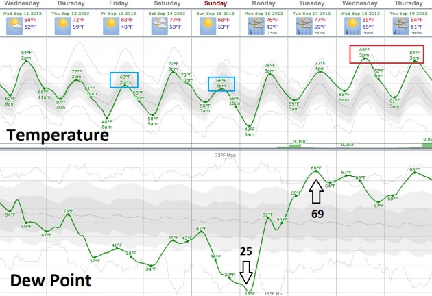
A Manic Pattern.
After one last day of low to mid 80s today, September returns later
this week on a stiff north breeze - highs may not climb out of the 60s
by Friday, again next Monday, nights dipping into the 40s according to
ECMWF guidance. But a surge of summerlike heat returns again next week,
in fact dew points are forecast to rise from 25 F. early Monday to 69 F.
by next Tuesday, a nearly four-fold increase in water vapor in the air.
More 80s the latter half of next week? Keep shorts (and light jackets)
handy. Graph: Weatherspark.
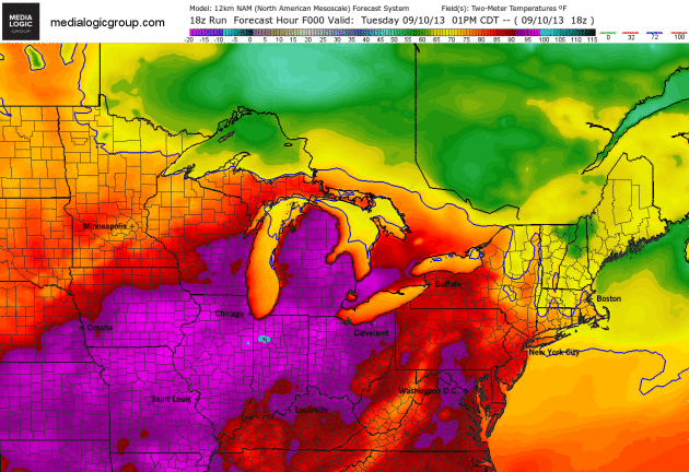
Canadian Infiltration.
And just like gravity, here comes the inevitable temperature tumble,
focused on the Great Lakes and New England by the end of the week. 84
hour NAM temperatures forecast courtesy of NOAA. Animation from Ham
Weather.
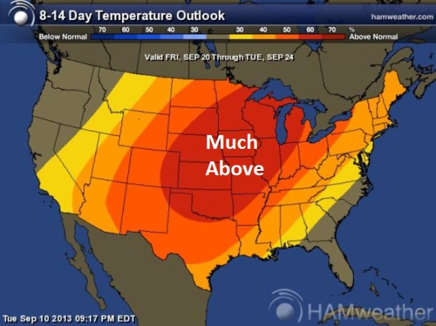
Warm Bias Into Late September?
NOAA CPC (Climate Prediction Center) shows much of the USA trending
warmer than average into the 3rd, possibly even the 4th week of
September, a warm bullseye over the Upper Midwest, Great Lakes and
Central Plains. Map: Ham Weather.
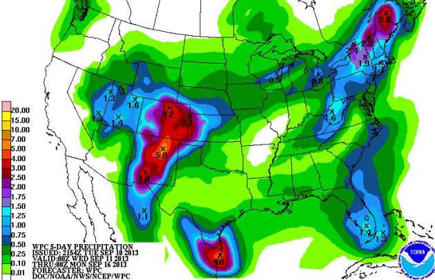
Central USA Continues To Dry Out.
The 5-day rainfall forecast from NOAA HPC shows some very heavy rains
(and flash flood potential) from New Mexico into Colorado, additional
heavy rain for much of northern New England, where it may be cold enough
over higher terrain for a little wet snow by Saturday. Big gulp.
Meanwhile rain will be spotty to non-existant for much of the central
USA.
"Flash Drought" Starting To Hurt. Here's a clip from
The Tomah Journal: "
Monroe
County is one of many Wisconsin counties coping with what the National
Weather Service calls a “flash drought.” The rapidly developing drought
has placed the area in moderate drought conditions. According to the
National Weather Service, the precipitation deficit, which shows how
little rain the area receives compared to an average year, is already
worse than during the 2012 drought and is growing rapidly. Tomah has
seen .972 inches of rain in the last month, compared to 3.36 inches last
year during the same time. The deficit, which is measured against the
average amount of rainfall between July 1 and Sept. 1 from 1981 to 2010,
is 6.56 inches..."
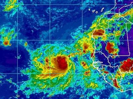
"Strange" Hurricane Season Perplexes Forecasters. More background on the eerily quiet hurricane season in this excerpted article from
HeraldTribune.com: "...
On
average, two hurricanes should have formed by now. Past seasons have
started slow and finished with a flurry of tropical cyclones, but the
window is starting to close. Phil Klotzbach, a research scientist with
Colorado State University's Tropical Meteorology Project, has been
perplexed by the hurricane season's progress so far. Klotzbach predicted
there would be 18 named storms this year, including eight hurricanes.
The average is 12 named storms and six hurricanes. Other forecasters,
including the National Oceanic and Atmospheric Administration, also
looked at the conditions that contribute to storm formation earlier this
year and similarly predicted a busy season..."
8 tropical storms in the Atlantic so far this year.
8 years since a major (Category 3+) hurricane has hit the USA (Wilma in 2005).
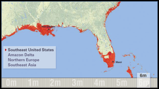
Risk Of Sandy-Level Flood In New York City Has Doubled Since 1950. Sea level rise is a huge mitigating factor, as
Climate Central explains: "...
Rising seas
are a consequence of manmade global warming, as well as local shifts in
land surface elevations. Sea level rise has accelerated in recent
years, from a rate of 1.7 millimeters per year between 1901 to 2010, up
to 3.2 millimeters per year between 1993 and 2010. Depending on how much
sea levels increase by the end of the century, the study said
Sandy-like flooding could occur once every few decades in Manhattan, and
on the order of once a year in parts of New Jersey and coastal
Connecticut. By raising the water level, sea level rise provides storms
with a higher launching pad for storm surges, which are bulges of water
caused by a storm's winds, forward motion, and atmospheric pressure, to
ride on top of..."
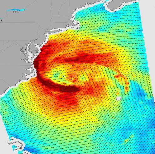
Image credit above: "NASA
visualization of the wind field associated with Hurricane Sandy as it
approached the Mid-Atlantic coast on Oct. 28, 2012. Wind speeds above 40
mph are yellow; above 50 mph are orange; and above 60 mph are dark red."
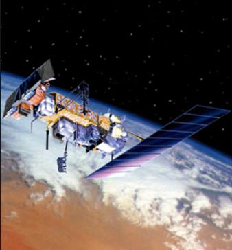
Industry May Have The Answer To Weather Forecasting Blind Spot (National Defense).
NOAA's polar orbiting satellites are reaching the end of their life
expectancy - and that has generated a lot of concern, since these
low-orbiting platforms provide the necessary raw data to computer models
that help us isolate everything from severe storm potential to
hurricane tracks. Here's a clip from
tmcnet.com: "...
The
National Oceanic and Atmospheric Administration's National
Polar-orbiting Operational Environmental Satellite System is nearing the
end of its lifespan. When decommissioned, NOAA will lose some of the
essential weather data provided by the system for between 17 to 53
months, the GAO found. The blind spot could materialize as early as
2014. "A satellite data gap would result in less accurate and timely
weather forecasts and warnings of extreme events, such as hurricanes,
storm surges and floods. Such degradation in forecasts and warnings
would place lives, property and our nation's critical infrastructures in
danger," said the GAO in its 2013 High Risk Report... (Image above: NOAA).
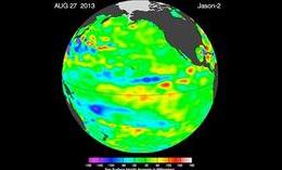
"La Nada" Climate Pattern Lingers In The Pacific.
We are in an ENSO-neutral situation in the Pacific, no significant
warming or cooling, although I still see a slight bias toward a milder
El Nino phase by winter or early 2014. Here's a clip from
KATC.com: "
New
remote sensing data from NASA's Jason-2 satellite show near-normal
sea-surface height conditions across the equatorial Pacific Ocean. This
neutral, or "La Nada" event, has stubbornly persisted for 16 months,
since spring 2012. Models suggest this pattern will continue through the
spring of 2014, according to the National Weather Service's Climate
Prediction Center. "Without an El Niño or La Niña signal present, other,
less predictable, climatic factors will govern fall, winter and spring
weather conditions," said climatologist Bill Patzert of NASA's Jet
Propulsion Laboratory, Pasadena, Calif. "Long-range forecasts are most
successful during El Niño and La Niña episodes. The 'in between' ocean
state, La Nada, is the dominant condition, and is frustrating for
long-range forecasters. It's like driving without a decent road map --
it makes forecasting difficult...."
Winter Depression May Be Less Common Than Believed. I did a double-take after reading this story from
U.S. News and World Report; here's an excerpt: "
Feel
the blues in the winter? You might blame seasonal affective disorder, a
form of depression that's thought to be driven by weather and the time
of year. Now, a new study raises questions about whether this condition
is as common as researchers have believed. "It is clear from prior
research that seasonal affective disorder exists," study lead author
David Kerr, an assistant professor in the School of Psychological
Science at Oregon State University, said in a university news release.
"But our research suggests that what we often think of as the winter
blues does not affect people nearly as much as we may think..."
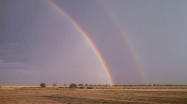
Double Rainbow.
This optical illusion is created when white sunlight is refracted, or
bent, twice within the same raindrops. Image courtesy of the
Goodland, Kansas National Weather Service.
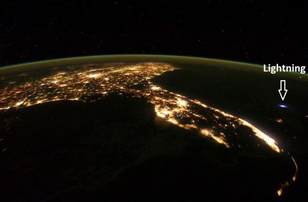
Amazing View.
Look carefully and you can see a cloud to cloud lightning discharge
just east of Florida, in this remarkable photo from the International
Space Station, courtesy of the
Miami NWS.
National University Rankings. Here's the latest annual list of top U.S. Universities, as calculated by
U.S. News and World Report. Cue the excuses, hand-waving arguments and trash-talking: "
...This
year's installment offers data on nearly 1,800 colleges and
universities, including tuition, acceptance rates, class sizes,
graduation rates, average debt of graduates and much more. Eligible
schools are ranked on up to 16 different factors, each weighted for
importance. U.S. News updated the methodology
for the 2014 rankings to reflect the current state of college
admissions and better measure student outcomes. High school class rank, a
figure included on fewer student transcripts, is less important in
college admissions decisions than in years past. As a result, class
standing received significantly less weight in this year's rankings..."
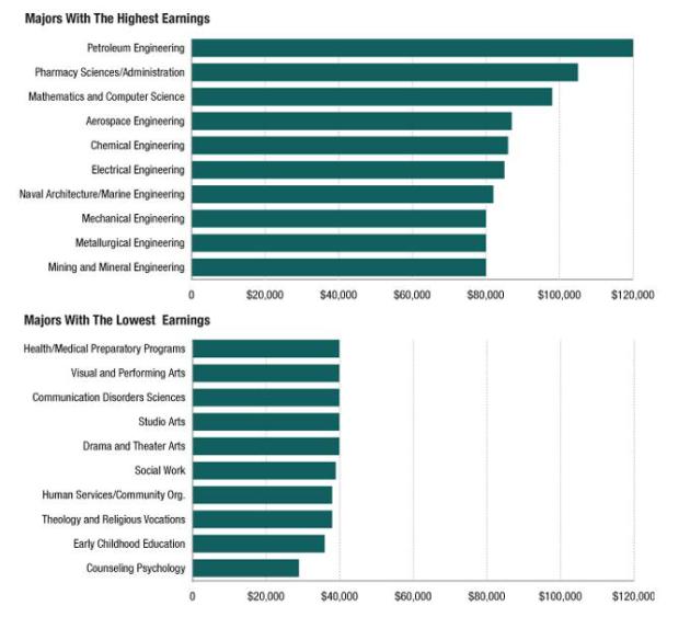
The Most (And Least) Lucrative College Majors, In One Graph. Oh, to have been smart enough to be an engineer.
NPR has the story; here's an excerpt: "...
What
you major in has a bigger influence over your income than where you go
to school, according to Anthony Carnevale, an economist at Georgetown
University. The graph (above) is based on Carnevale's research — and it
shows the huge range in median earnings for people with different majors..."
Graphic credit above: "
Figures
are median income for all full-time workers with bachelor's degrees in
each subject. Workers with graduate degrees are not included in the data." Source: Anthony Carnevale, Georgetown University. Credit: Matt Stiles/NPR.
44 Of The World's 72 Tallest Buildings Are Cheating. Here's a snippet from
Quartz: "
It
turns out that most of the world’s tallest buildings are doing the
architectural equivalent of wearing platform shoes. That is, they’re
scraping skies courtesy of dozens—sometimes hundreds—of meters of
“vanity height,” says a new report (pdf) by the Council on Tall Buildings and Urban Habitat (CTBUH), first spotted by io9. That’s the term CTBUH uses to describe the distance between the highest floor occupied and the top of the building.."
Graphic credit above: "
There's a lot of puff built into the world's tallest buildings." AP Photo/Shiva Menon/Solent News/Rex Features.
The Entire World Is Slightly Happier Than It Used To Be. Some good news on a Wednesday; but #17. Really? At least we're happier than the French. Here's a clip from a story at
The Los Angeles Times: "...
Let’s
cut to the chase: The five happiest countries on Earth are Denmark,
Norway, Switzerland, the Netherlands and Sweden. This despite the fact
that they all experience cold, dark winters. All five countries are
pretty much as happy as they were the last time the report was
published. The United States ranked as 17th-happiest country -- slightly
happier than the citizens of Ireland (No. 18) and a little less happy
than our neighbors in Mexico (No. 16). Americans saw their overall
happiness drop by about 3% over the five-year period between surveys.
Canadians are the sixth-happiest people in the world. Israelis came in
at 11th, and the French rank 24th..."
85 F. high in St. Cloud Tuesday.
73 F. average high for September 10.
83 F. high on September 10, 2012.
.04" rain fell yesterday at St. Cloud.
TODAY: Warm sun, less humidity in the air. Dew point: 56. Winds: West 10-15. High: 84
WEDNESDAY NIGHT: Clear and comfortable. Low: 60
THURSDAY: Blue sky, cooler. Dew point: 46. High: 73
FRIDAY: Early sweatshirt. Bright sun. Brisk. Wake-up: 49. High: 69
SATURDAY: Sunny and milder. Wake-up: 51. High: 78
SUNDAY: Another cool jab (reinforcing cool front). Sunny. Dew point: 36. Wake-up: 51. High: 69
MONDAY: Sunny start, rain arrives late. Wake-up: 45. High: 74
TUESDAY: AM T-storms. Milder, more humid. Wake-up: 59. High: 79
* 80-degree highs are likely the latter half of next week.
Climate Stories....
Extreme Weather: More To Come? Here's a clip from a
Washington Post story: "...
In a report
published online last week in the Bulletin of the American
Meteorological Society, scientists with the National Oceanic and
Atmospheric Administration (NOAA) tackled this question head-on. The
report — the second such annual report — analyzes the findings from
about 20 scientific studies of recent extreme weather events that
occurred around the world, seeking to parse the relative influence of
anthropogenic, or human-influenced, climate change. The overall message
of the report: It varies. “About half of the events . . .
reveal compelling evidence that human-caused change was a [contributing]
factor,” said NOAA National Climatic Data Center Director Thomas Karl
at a press conference accompanying the release of the report..."
Photo credit above: (Bloomberg News) - "
In Union Beach, N.J., debris surrounds the front steps of a home destroyed in Hurricane Sandy last November."
Rising Sea Levels Ranked As Greatest Climate Change Threat: Guy Carpenter. Here's a clip from a story at
Insurance Journal: "...
As
the planet warms up it leads to a rise in sea levels, which Guy
Carpenter describes as the “single greatest threat posed by global
warming.” The rise is “expected to increase coastal flood frequency and
severity from tropical cyclones, extra tropical cyclones and tsunami
events. “According to the IPCC, a sea-level rise of at least one to two
feet can be expected by the end of the century, though a wide range of
sea-level rise scenarios exist. The growing urban footprint and
increasing population density in coastal areas has also amplified the
financial and societal impacts of such events..."
Cooling Pacific Has Dampened Global Warming.
An unusually strong and persistent La Nina cooling phase may be masking
some of the greenhouse gas-related warming of the atmosphere. Here's a
snippet of a story from
Grist: "
Cooling
waters in the tropical Pacific Ocean appear to be a major factor in
dampening global warming in recent years, scientists said on Wednesday.
Their work is a big step forward in helping to solve the greatest puzzle
of current climate change research — why global average surface
temperatures, while still on an upward trend, have risen more slowly in
the past 10 to 15 years than previously. Waters in the eastern tropical
regions of the Pacific have been notably cooler in recent years, owing
to the effects of one of the world’s biggest ocean circulatory systems,
the Pacific decadal oscillation..." (Image above: Think Progress).
Climate Change May Affect Wheat Yields. Here's an excerpt from
agriculture.com: "
Growing
a healthy, high yielding wheat crop takes years to master and requires
hard work and commitment. Climate change brings on a series of problems,
and a quality drought-resistant variety that is resistant to pests and
diseases is essential. Over a 26-year period, Kansas State University
examined wheat variety yield data from performance tests, along with
location-specific weather and disease data. The tests were done to
quantify the impact of genetic improvement in wheat, disease, and
climate change. Through the years of 1985 through 2011, wheat breeding
programs boosted average wheat yields by 13 bushels per acre, or 0.51
bushels each year, for a total increase of 26%. A simulation also found
that 1.8 degree Fahrenheit in projected mean temperature was found to
decrease wheat yields by 10.64 bushels per acre or nearly 21%. “Kansas
wheat producers are challenged by weather, pests, and disease,” said
Andrew Barkley, Professor of Agricultural Economics “Fortunately, the
Kansas wheat breeding program produces new varieties of wheat that
increase yields over time...”
Climate Change "Will Exacerbate Existing Problems" : Defense. Here's a clip from the
ABC Network in Australia: "...
The Australian Government's latest Defense White Paper,
published in May, found that global energy, food and water resources
were under pressure from population growth, rising affluence and climate
change. "As a frequent first responder to national and international
emergencies, Defence needs to be prepared for some of the consequences
of global climate system changes, such as potentially increased demands
for the Australian Defence Force to undertake humanitarian and disaster
relief responses both domestically and across the region."
As a threat multiplier, it has the potential to generate and exacerbate
destabilising conditions that could reshape the regional security
environment." The commander of the US Navy in the Pacific,
Admiral Samuel Locklear, agrees climate change is a real threat to
peace. Earlier this year he said climate change was the greatest long-term security threat for his region..."
Photo credit above: "
As first responders and humanitarian assistance providers, the armed forces will be busy in a climate changed future."
Credit: Australian Defence Image Library.
 Air Pollution Worsened By Climate Change Set To Be More Potent Killer In 21st Century
. Here's a clip from a recent story at
Science Daily: "...
Climate
change is believed to harm human health in a variety of ways, including
through adverse changes in food production, heat stress, sea level
rise, increased storm intensity, flooding and droughts, and increased
incidence of vector-borne diseases. In addition, climate change
indirectly impacts health by influencing concentrations of air
pollutants, such as surface ozone and fine particulate matter (smaller
than 2.5 micrometers in diameter), including sulphate, nitrate, fine
dust particles and black carbon. These pollutants are linked with
increased risks of lung cancer and respiratory, cardiopulmonary,
cardiovascular and all-cause deaths..."
Dealing In Doubt: Greenpeace Report Exposes Fossil Fuel Funded Climate Denial Machine. The Greenpeace report is
here;
Desmogblog.com has an overview - here's an excerpt: "
As the Intergovernmental Panel on Climate Change prepares to release its Fifth Assessment Report (AR5) -- the latest installment of its comprehensive assessment of climate science -- early next year, the science is already under attack. As the U.S. Global Change Research Program puts the final draft of the third National Climate Assessment together, also due out in early 2014, its conclusions are already under siege. In an updated report released today,
Greenpeace explains how these attacks on the science of climate change
-- on the reports, on the scientists themselves, and on the rigorous
scientific process itself -- are part of a decades-old, well-organized,
and richly-funded campaign to discredit the science of climate change
and to intentionally pollute public discourse on climate change..."
The World Does Need a Red Line - On Climate Change. The Guardian has the Op-Ed; here's an excerpt: "
Two
degrees doesn't seem like much, but it takes only a few Google searches
to connect the dots between the one degree of warming that has already
set in, and catastrophic events like Hurricane Sandy, unprecedented
wildfires in the American west and record flooding in places like the
Philippines and Pakistan. Some have even pointed to extended climate-induced drought in Syria
as a key driver of the conflict there. It doesn't take much sleuthing,
either, to find out that humans have loaded so much carbon into the
atmosphere by burning fossil fuels, cutting down forests and engaging in poor agricultural practices, that the IPCC says
it's now 95% certain that we're responsible for most of the warming
that has happened since the industrial revolution. Despite decades of
science showing human impact on the atmosphere, and the availability of
renewable energy options, from cheap solar to wind to geothermal,
political will to deal with climate change in the world's richest countries has flatlined..."
Photo credit above: "
President Barack Obama wipes perspiration from his face as he speaks about climate change in Washington." Photograph: Charles Dharapak/AP.


No comments:
Post a Comment