Cat 6
There's
no such thing as a Category 6 hurricane, of course, but "Haiyan" would
be a good candidate, if there was. 3.5 times stronger than Katrina,
Super Typhoon Haiyan punished the Philippines with 195 mph sustained
winds - possibly the strongest land-falling tropical cyclone ever
observed. It was roughly equivalent to an EF-4 tornado, only this one
was 40 miles in diameter, lasting 2-3 hours.
No, compared to much
of the world, where typhoons, earthquakes, volcanoes and debilitating
smog are ongoing threats, we don't have much to complain about.
I
expect some (minor) gripes & groans next week, as the coldest air of
the season (so far) gives Minnesota a glancing blow. We're not talking
Nanook, but highs may hold in the 20s Tuesday, before rebounding into
the 40s again by late week. Nothing even vaguely resembling a "storm" is
shaping up for the next 7-8 days. No travel-related weather headaches
for the foreseeable future.
Mid-November weather can be all over
the map. On this date in 1943 a severe ice storm shut down the Twin
Cities; 15" snow at Marshall. But in 1999 the mercury hit the 70s at
MSP; a balmy 82F at Canby. Something for everyone.
No weather-drama here anytime soon.
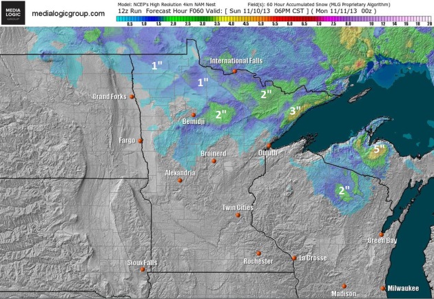
Tracking Snow for Deer Hunting Opener.
A couple of clippers may drop 1-2" snow on far northern Minnesota,
maybe 3" along the North Shore of Lake Superior, with 5" of lake effect
snow for portions of the U.P. of Michigan. Otherwise it looks pretty
quiet out there looking out 60 hours. 4 km NAM snowfall forecast
courtesy of NOAA and
Ham Weather.
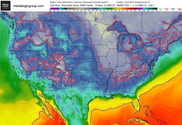
Glancing Blow.
Here comes the cold air - not quite bitter, but cold enough to get your
attention by Monday and Tuesday across the Upper Midwest. The solid red
line is the 32F isotherm, chilly winds pushing deep into the south by
the middle of next week. 12 km 2-meter NAM temperature trend courtesy of
NOAA and Ham Weather.
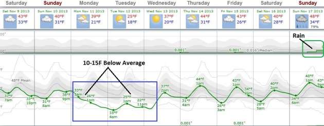
Goosebump Potential.
After enjoying (?) low to mid 40s today and Sunday Canadian air drops
highs through the 30s Monday; we may not climb out of the 20s Tuesday in
spite of blue sky and a bright, pleading sun. No worries - ECMWF
guidance shows 40s returning the latter half of next week, maybe some
rain by Sunday of next week. Graph: Weatherspark.
No Prolonged, Extended Cold Air Outbreaks - Yet.
GFS guidance shows a run of 40s, maybe even a few 50s, around November
18-20; no major storms imminent looking out about 2 weeks.
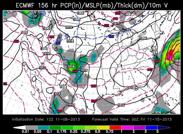
Stormy Reprieve For The East Coast?
Yesterday the models were looking ominous for the East Coast, a
potential nor'easter brewing. But the most recent runs of the ECMWF
(European) model keep the storm farther out into the Atlantic, with a
lowered risk of snow, rain and beach erosion from the Outer Banks to
Cape Cod. Map above valid next Thursday evening, courtesy of WSI.
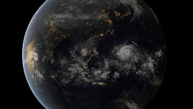
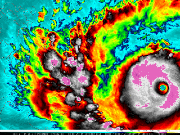
Super Typhoon Haiyan.
Here is more (meteorological) information about what may have been the
strongest landfalling tropical cyclone ever observed - courtesy of the
CIMSS Weather Blog at the University of Wisconsin-Madison: "
Super
Typhoon Haiyan (31W) formed on 03 November 2013, and by 18 UTC on 07
November was estimated to have peaked at an intensity of sustained 170
knot winds with gusts to 205 knots (Storm track map | ADT plot | JTWC warning text). 10.8 µm IR channel images from the Korean COMS-1 satellite (above; click image to play animation)
showed the intense tropical cyclone as it moved westward toward the
Philippines. There was a large, nearly symmetric ring of very cold
cloud-top IR brightness temperatures in the -80 to -90º C range (violet
colors) – and at times there were a few isolated pixels colder than -90º
C (yellow enhancement)..."
* here's a good source of continuously updating damage/recovery information for the Philippines at
The New York Times.
 A Few Highlights From The First Annual Minnesota Climate Adaptation Conference
.
Held at the Science Museum on Thursday, organizer and climate-guru Dr.
Mark Seeley has a few highlights and observations in his weekly
WeatherTalk Newsletter: "
Over
250 people attended, representing state agencies, local units of
government, NGOs, academic institutions, industries, and others.
-
Participants discussed climate impacts on transportation, agriculture,
public health, energy use, urban planning, watershed management,
forestry, and the insurance industry.
- Climate
change is already having an impact on insurance, Minnesota was the only
Midwestern state among the top 3 states with the highest insured
catastrophic losses in both 2007 and 2008. Homeowners claims related to
severe weather like hail and wind damage are up, as are average
homeowner insurance premiums. Minnesota ranks 14th highest among
states in homeowners insurance premiums and has seen a rise of over 267
percent in these costs since 1997. Not all of this is related
directly to climate change, but some features of severe weather threats
are changing and have at least partially had an effect.
-
Minnesota DOT is quite concerned about climate change in the context of
severe weather. Damage to roads and highways from the flash flood in
Duluth, Cloquet, and Two Harbors in June of 2012 totaled over $50
million..."
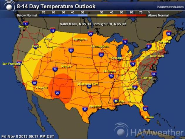
Mild Bias Into Third Week Of November.
In spite of a glancing blow of cold air the first few days of next week
NOAA CPC shows a mild bias from November 18-22 over much of the USA.
Map:
Ham Weather.
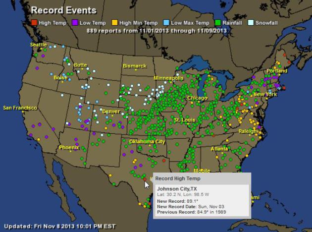
This Week's Weather Records.
NOAA data shows a total of 889 individual 24-hour weather records in
the last 7 days, mostly record rainfall amounts. Johnson City, Texas
soared to 89.1F last Sunday. For an interactive map click
here; data from Ham Weather.
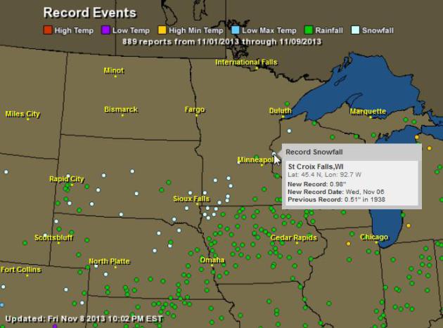
Midwest Records.
St. Croix Falls, Wisconsin set a record on Wednesday with nearly 1" of
snow. Other 24-hour snowfall records were set over southwestern
Minnesota, scores of rainfall records (green dots) from Nebraska into
the Ohio Valley and Great Lakes. Data: NOAA and Ham Weather.
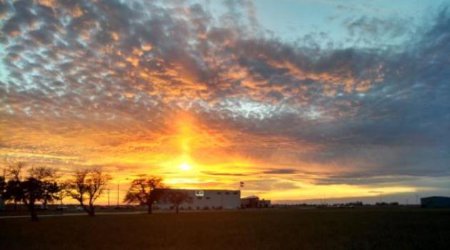
Sun Pillar. Here's one of my favorite optical illusions. Wikipedia defines a sun pillar a
a visual phenomenon created by the reflection of light from ice crystals with near horizontal parallel planar surfaces. Exactly. This fine example courtesy of the
Quad Cities National Weather Service.
New Asteroid That "Belches Out Dust" Discovered.
CNN has the curious story - here's the introduction: "
What's
that in the sky? Is it an asteroid? A comet? A lawn sprinkler? Turns
out a newly discovered object is a little bit of all three -- minus the
fact that you won't find many green lawns millions of miles from Earth
-- NASA announced Friday. "We were literally dumbfounded when we saw
it," David Jewitt, who leads the team exploring the "asteroid with six
comet-like tails of dust radiating from it like spokes on a wheel..."
Image credit
above: "This NASA Hubble Space Telescope reveals a never-before-seen
set of six comet-like tails radiating from a body in the asteroid belt,
named P/2013 P5. The asteroid was discovered as an unusually
fuzzy-looking object with the Panoramic Survey Telescope and Rapid
Response System survey telescope in Hawaii."
David Levinson's Vision Of The Future. How will technology shape the way we work in the near future? Here's anexcerpt of an interesting vision/prediction at
National Review: "...
Just
as it was once standard for U.S. workers to work a six-day week,
Levinson imagines that the workweek will continue to shrink. Every-other
Friday off (the 5/4 schedule) becomes standard by 2015; by 2020, the
standard schedule becomes a 9 hour day with four days a week in the
office and 4 additional hours of checking in from home; by 2025, workers
are taking every-other Monday off (the 4/3 schedule); and by 2030, the
“flipped” office, like the “flipped” classroom, becomes the norm — i.e.,
workers do the bulk of their work at home, and they come to the office
for “interactive collaboration days...”
Living Small - And Off The Grid. Yes, it's tempting. WIFI, a big screen TV, a nice reading lamp and indoor plumbing (maybe a tiny microwave?) and I'm there.
Gizmag has the details: "
Canadian
company NOMAD Homes has produced a new concept micro-home that measures
just 100 sq ft (9.2 sq m), ships as a flat-pack, can operate off-grid,
and is said to be easy-to-build. The firm has turned to Indiegogo to
raise funds for manufacturing, and eventually intends to sell the base
version of the home for under US$25,000..."
Toronto Tailor Introduces Bullet-Proof Three-Piece Suits. Because you just never know when this will come in handy.
The Globe and Mail has the story; here's the intro: "
Last
weekend at Garrison Bespoke, an upscale tailor shop in Toronto, a
potentially lethal scene was unfolding in the back room, where employees
were taking turns trying to stab Michael Nguyen, Garrison’s co-owner,
with a hunting knife. Surprisingly, Mr. Nguyen remained unscathed,
thanks to the Donegal tweed vest he was wearing – part of a
hand-tailored three-piece “bulletproof” suit – which he believes is the
first of its kind produced in Canada – that Garrison’s is unveiling to
members of the media on Tuesday at the Ajax Rod and Gun Club.."
Chocolate Lovers Rejoice: More Chocolate Means Less Body Fat. I know, it sounds too good to be true, but read on Dear Reader.
Gizmag.com has the story; here's the introduction: "I
n what may be the best news for chocoholics since scientists at the University of Cambridge found that higher chocolate consumption
was associated with a significant reduction in cardiovascular disease,
diabetes and stroke, researchers at the University of Granada are
reporting that it's also associated with lower levels of total fat
deposits – in the bodies of adolescents at least..."
Photo credit: "
A new study has found a link between higher chocolate consumption and lower body fat levels." (Photo:
Shutterstock).
40 F. high temperature yesterday at St. Cloud.
44 F. average high on November 8.
51 F. high on November 8, 2012.
.01" rain fell yesterday at St. Cloud.
Minnesota Weather History on November 8 (courtesy of the MPX National Weather Service):
2003:
Parts of west central and north central Minnesota received anywhere
from 2 to 6 inches of new snow. Canby had the most at 6 inches and
Benson measured 5 inches.
1977: A foot of snow falls in Western Minnesota. I-94 is tied up.
1850: The sky darkened at Ft. Snelling due to prairie fires.
SATURDAY: More clouds than sun, cool breeze. Winds: NW 15-25. High: 41
SATURDAY NIGHT: Clear to partly cloudy. Low: 21
SUNDAY: Chilly start. Sun fades by PM. Winds: SW 8-13. High: 40
MONDAY: Patchy clouds, a much colder wind. Wake-up: 25. High: 28 (falling during the day)
TUESDAY: Bright sun, coat-worthy. Wake-up: 11. High: 24
WEDNESDAY: Breezy, not as cold. Wake-up: 14. High: 36
THURSDAY: Some sun, light winds. Wake-up: 27. High: 41
FRIDAY: Mostly cloudy, probably dry. Wake-up: 25. High: near 40
Climate Stories...
"
But don't you realize my feelings are at least as important as your facts?"
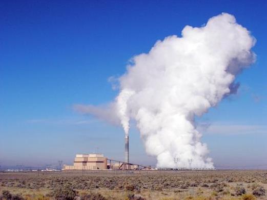
Photo credit: Utah Geological Survey.
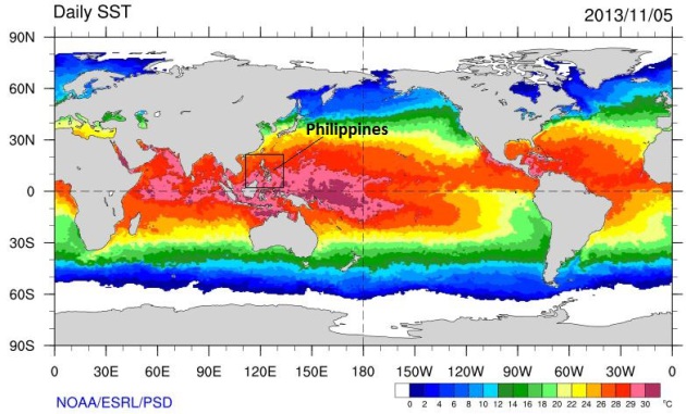
Did A Pacific Ocean Warmed By Climate Change Make Haiyan More Intense?
The idea isn't as far fetched as it sounds, but we don't have enough
data (yet) to connect the dots with a high degree of confidence. There's
no question that higher sea levels made the storm surge even worse than
it would have been. Keep in mind that 90% or more of observed warming
is going into the world's oceans, less than 2-3% warming the atmosphere,
the rest going into melting ice. Climate models aren't predicting more
numerous hurricanes and typhoons, but they do suggest that the storms
that DO form have a much better chance of becoming extreme. Haiyan
certainly fits that definition. Here's an excerpt from a fact sheet at
Climate Nexus: "
There
are several ways in which climate change can affect typhoons like
Haiyan, and will continue to do so in the future, including:
- Sea surface temperatures are fueling typhoon Haiyan by
increasing available energy and water vapor. Sea surface temperatures
near the Philippines are exceptionally warm: 2ºC above normal in a small region, on top of baseline global warming of 0.6ºC. Sea surface temperatures have been steadily increasing around the world’s oceans, and are projected to continue to rise.
- Extreme rain is a threat in
the mountainous Philippines, as it can cause dangerous flash floods and
landslides. Haiyan is expected to deluge a 50-mile swath of the
Philippines with over eight inches of rain. Climate change is projected
to increase the precipitation associated with tropical cyclones by 20% by the end of the century.
- Sea level rise increases the destructive power of storm surges. Climate change has already contributed about eight inches to global sea level rise, and this will continue to worsen the impacts of typhoons...
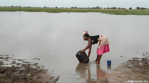
U.N. Expert Warns Climate Change Is Causing Loss Now.
Deutsche Welle has the article; here's an excerpt: "...
For
our study, loss and damage refers to the negative impacts of climate
variability and climate change that people haven't been able to cope
with or adjust to. For example, worldwide, people struggle with rain.
Farmers especially. If rain comes too early, or too late, the seeds that
they have planted don't grow, or they get washed away. Sometimes, if
the rain comes too late, the seedlings just die, and farmers don't have a
way to adjust to that kind of stressor. What people try to do if they
can't grow enough food is try to eat less. But, of course, there is only
so much less that people can eat before they start feeling hungry or
the impacts of malnutrition. We cite choices about food all throughout
our study - that's one example of not being able to do enough to adjust
to these climate stressors..."
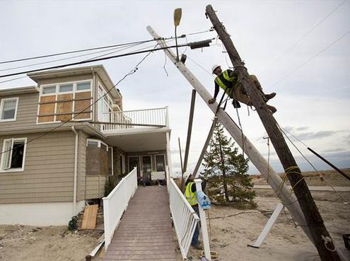
It's Time To Adapt To Unstoppable Global Warming, Scientists Say.
Well no, most scientists I know say we need to mitigate (ie.
dramatically reduce) the greenhouse gasses, the carbon waste being
pumped into the atmosphere first, and then figure out ways to adapt to
inevitable warming and sea level rise. Here's an excerpt from
NBC News: "
Even
if the world's 7 billion people magically stop burning fossil fuels and
chopping down forests today, the greenhouse gases already emitted to
the atmosphere will warm the planet by about 2 degrees Fahrenheit by the
end of this century, according to scientists who are urging a focused
scientific effort to help humanity adapt to the changing climate..."
Photo credit above: John Makely / NBC News. "
In this 2012 file photo, a lineman works to repair storm damage to a utility pole in Breezy Point, NY."
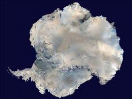
Oldest Air In The World May Be Trapped Deep In The Antarctic Ice Sheet.
The Los Angeles Times has the article; here's a clip: "
Tiny
bubbles of air buried deep in the ice of Eastern Antarctica may contain
bits of the Earth's atmosphere as it was 1.5 million years ago,
according to a new report. "Ice is a great medium for trapping air,"
said Ed Brook of Oregon State University, one of several authors of a paper in the journal Climate of the Past that describes where this ancient ice might be. "It traps it without altering it very much..." (Image above: NOAA).
Climate Contrarians Are More Celebrity Than Scientist. Here's an excerpt of a
Guardian story written by St. Thomas climate scientist John Abraham: "
By
now, we must all be aware that it no longer takes hard work and talent
to become a celebrity. The media (and public) are drawn to loud and
flamboyant caricatures, not careful and studious characters. To most
this means not much more than the annoyance of hearing about the latest
celebrity "scandal." But for all of us here on planet Earth, it has very
real consequences. New research clarifies exactly what those
consequences are: Celebrities in scientists' lab coats have played a
role in the public discourse on climate change that far outweighs their scientific credibility. In the journal Celebrity Studies,
Dr. Maxwell Boykoff and Shawn Olson trace the history of climate
contrarians back to the 1980s and discuss their potential motivations
and strategies..."
Photo credit above: "
Some
climate contrarians have achieved celebrity status, but sometimes
celebrity can be a bad thing, as with the Heartland Institute's
Unabomber billboard." Photograph: The Heartland Institute.
Cosmic Rays, Solar Activity And The Climate. No, cosmic rays can't account for all the warming we're seeing, worldwide. Here's a clip from
IOPScience: "
Although
it is generally believed that the increase in the mean global surface
temperature since industrialization is caused by the increase in green
house gases in the atmosphere, some people cite solar activity, either
directly or through its effect on cosmic rays, as an underestimated
contributor to such global warming. In this letter a simplified version
of the standard picture of the role of greenhouse gases in causing the
global warming since industrialization is described. The conditions
necessary for this picture to be wholly or partially wrong are then
introduced. Evidence is presented from which the contributions of either
cosmic rays or solar activity to this warming is deduced. The
contribution is shown to be less than 10% of the warming seen in the
twentieth century..."
* LiveScience has more details on the question of cosmic rays and warming
here.
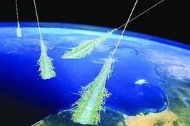
Image above courtesy of Live Science: "An artist's concept of the shower of particles produced when Earth's atmosphere is struck by ultra-high-energy cosmic rays." Credit: Simon Swordy/University of Chicago, NASA.


I would surely give 10 on 10 for such incredible content. best wordpress themes
ReplyDelete