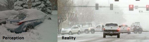
Snow Inflation
Anyone
who tries to tell you how many inches of snow will fall on your yard
beyond 24-36 hours is trying to sell you something. Buyer beware.
Meteorologists, as a profession, over-predict snow.
No kidding, Paul.
Why?
One of our biggest fears is hearing this: "You said flurries, but what
about the FOOT of flurries in my driveway?!" So we compensate.
Over
30 years I've discovered, the hard way, that it pays to be conservative
with snowfall amounts; try not to go off the deep end. Because Mother
Nature always finds a new and exotic way to kill off most anticipated
snowstorms.
A friend summed it up best: "If I take the average
snow predictions from all MSP media sources and divide by 2.5 I get a
much better estimate of what will really fall."
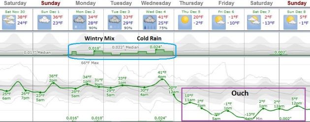
Pound in the
driveway stakes today as temperatures thaw into the upper 30s; no
problems getting home Sunday. A nuisance coating is possible on Monday
but the main event comes Wednesday, as a storm tracks toward Minnesota.
The challenge: what flavor storm? This system may pull enough mild air
north for mostly rain in the metro; plowable snow possibly confined to
western and central Minnesota by midweek.
High confidence: one of
the 2 or 3 coldest blasts of winter is brewing for late next week, with
highs holding in single digits. Uffda!
Taking A Swan Dive Off The Temperature Cliff.
Temperatures trend milder than average into Wednesday of this week,
followed by a serious temperature readjustment. ECMWF guidance shows
highs holding near zero Friday, rising into single digits next weekend.
Something to look forward to. The approach of this numbing front sparks a
wintry mix Monday into Tuesday, changing to mostly rain Wednesday as a
surge of warm air aloft sweeps northward. And then the bottom drops out.
Graphic: Weatherspark.
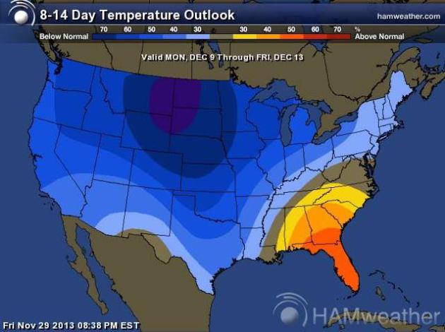
8-14 Day Temperature Anomalies.
As if there was any doubt it's going to get NANOOK across much of the
USA, NOAA CPC's 8-14 day temperature trend, valid December 9-13, shows
the epicenter of chill over the Northern Plains next week, a warm bias
over the southeastern U.S. Map: NOAA and
Ham Weather.
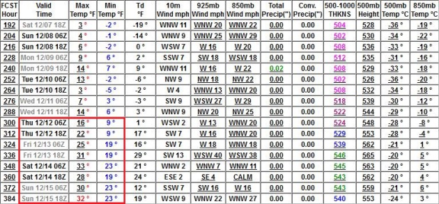
A Light At The End Of The Yukon-Tunnel?
I expect about 5-6 days of Canadian Pain, followed by some recovery by
mid-December. One of the great mysteries and perverse delights of winter
in Minnesota is just how good freezing feels after flirting with zero
for a few days. GFS numbers above: NOAA and MeteoStar.
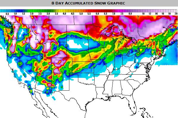
8-Day Snowfall Forecast.
This is quite a chance from yesterday, showing a more northerly track
to the midweek storm, dumping heavy snow on northern North Dakota and
the Red River Valley. A surge of warmer air out ahead of this vigorous
low may spark mostly rain from the Twin Cities into southern Minnesota.
It's still too early for specific, but there's no doubt that a wedge of
bitter air will reach us by the end of the week. NOAA NAM guidance: Ham
Weather.
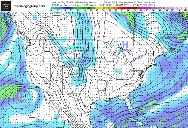
Twin Systems To Watch.
The loop above is from NOAA's GFS model, showing predicted surface
pressure and 10-meter wind speeds looking out 8 days. A strong storm is
forecast to track across the northern USA later this week, dragging the
coldest air of the winter season, to date, into much of the USA. Keep an
eye on possible coastal storm development over the Carolinas, possibly
pushing heavy rain/snow and high winds up the east coast by midweek.
Animation: Ham Weather.
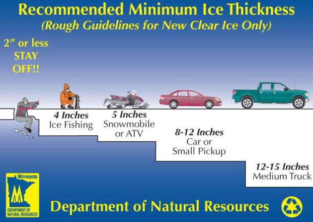
Stay Off The Ice.
It hasn't been cold enough, long enough for ice to come anywhere close
to being thick enough and safe enough to support people, much less
snowmobiles and vehicles. With bitter air in the forecast the second
week of December ice conditions may improve dramatically by
mid-December, but probably not until then. Here's more information on
ice safety from
NOAA and the Minnesota DNR.
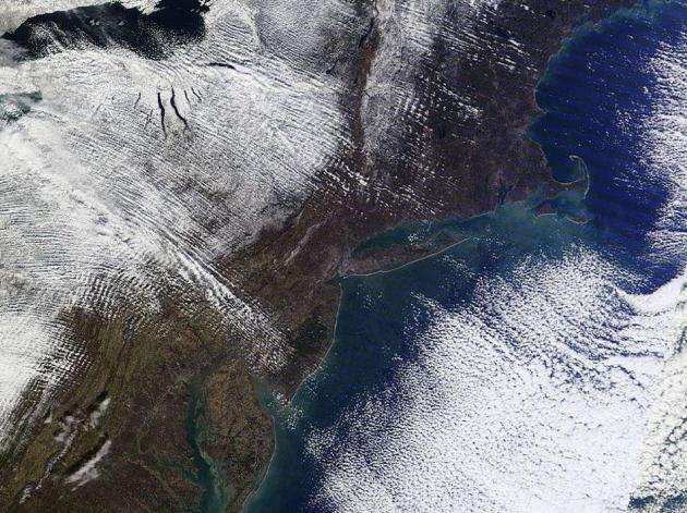
Northeast Snow Cover.
The computer models overestimated how much snow would fall over the
Appalachians, but you can see which parts of the Mid Atlantic and New
England enjoyed a white Thanksgiving. Satellite image: NOAA.
Czech Research Shows Air Pollution Causes Genetic Damage. I stumbled upon this story at
The Prague Monitor - here's the intro: "
Czech
scientists, using the latest data on the population's health, have
found out that air pollution causes a significant genetic damage,
transferrable to further generations, a research conducted by Prague's
Institute of Experimental Medicine (IKEM) has shown. The molecular
genetics method applied to newborn children showed changes in the
expression of genes that can influence the child's proneness to sickness..."
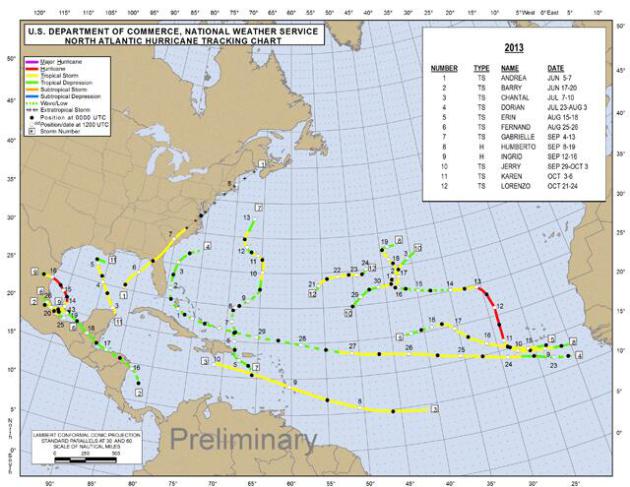
Quietest Atlantic Hurricane Season Since 1982.
Only 2 hurricanes spun up, due to a head-scratching mix of wind shear,
dry air and too much dust sweeping off the coast of Africa. Map above:
NOAA SPC.
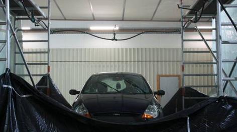
Moving Cars Could Be Used To Measure Rainfall.
Rainfall intensity estimates based on real-time windshield wiper
settings? Interesting, but isn't it just easier turing on the Dopple
radar? Maybe I'm missing something here.
Gizmag has the story; here's the intro: "
Rain
gauges are generally pretty accurate at measuring the amount of
precipitation that has fallen at their location, but they can't be
everywhere. This means that average rainfall figures for a region could
be inaccurate, if considerably more or less rain has been falling in
unmonitored areas. Cars, however, are just about everywhere that there
are roads. With that in mind, researchers from Germany's University of
Hanover are looking at using them to tell us how much water is coming
from the sky..."
Inbreeding Shaped The Course Of Human Evolution. Well this explains a lot. Here's a clip from a story at
New Scientist: "
TALK
about an inauspicious beginning. For thousands of years our ancestors
lived in small, isolated populations, leaving them severely inbred,
according to a new genetic analysis. The inbreeding may have caused a
host of health problems, and it is likely that small populations were a
barrier to the development of complex technologies..."
Santa's Little Helper.
Looking for a specific gift on-line? I've had remarkably good luck
tracking down hard to find items (especially electronics) at
nowinstock.net.
Plug in the item you're looking for and you'll get an alert from one of
dozens of sites (including Amazon, Best Buy, Target and Walmart) has
new inventory available online. Best of all - it's free.
30 F. high in St. Cloud Friday.
31 F. average high on November 29.
36 F. high on November 29, 2012.
Minnesota Weather History on November 29. Source: Twin Cities National Weather Service:
2000:
A surface low pressure system which moved over extreme southwestern
Minnesota from South Dakota, continued southeast into northern Iowa
during the evening hours on the 30th. The heaviest snow reported was in
the 6 to 8 inch range, and fell in a narrow band just southwest of the
Minnesota River in and around the Canby(Yellow Medicine County) and
Madison(Lac Qui Parle County) areas. Northeast winds rising out of the
Minnesota river valley up the slopes of the Buffalo Ridge in southwest
Minnesota helped enhance snowfall amounts. The northeasterly winds
between 10 and 20 mph were responsible for producing visibilities in the
one to two mile range.
1991: A storm dumps 14 inches in the Twin Cities in about 12 hours.
1896: Quite chilly across Minnesota. 45 below zero at the Pokegama Dam.
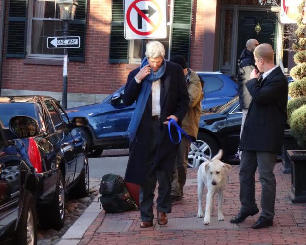
Secretary Of Dog-Walking.
I'm in Boston celebrating Thanksgiving with family. Walking around the
Beacon Hill area we stumbled on this sight: Secretary of State John
Kerry walking his dog, surrounded by Secret Service and a colorful
assortment of Swat Teams. Call me crazy, I find it vaguely reassuring
that the Sec. of State walks his own dog.
TODAY: Partly sunny & mild-ish. Winds: West 10. High: 37
SATURDAY NIGHT: Partly cloudy. Low: 21
SUNDAY: Clouds increase, still dry. Good travel weather. Winds: SE 5. High: 33
MONDAY: Very light snow possible. Coating of flurries? Wake-up: 25. High: 31
TUESDAY: Cloudy, travel still OK. Wake-up: 26. High: 31
WEDNESDAY: Cold rain metro. Heavy snow northern and western MN? Wake-up: 28. High: 34
THURSDAY: Blustery, turning sharply colder - falling temperatures. Wake-up: 13. High: 14
FRIDAY: A fresh Siberian breeze. Wind chill: -15. Wake-up: -5. High: 2
Climate Stories....
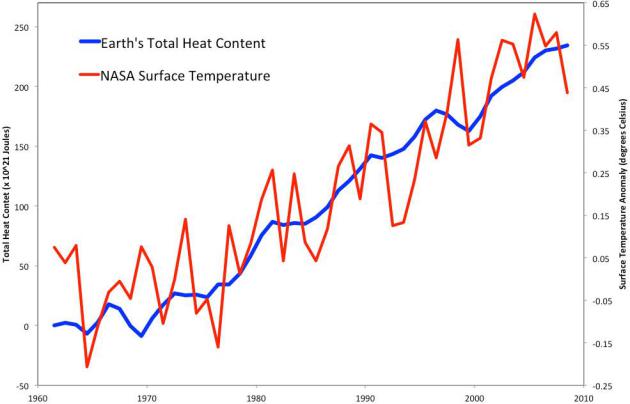
Deep Ocean Offers Hints of Warming. Truthdig.com has the story - here's an excerpt: "
US
and British researchers may have identified the fingerprint of global
warming in one of the darkest, coldest, most mysterious places on the
planet. Four thousand metres below the sea surface, at the bottom of the
north-east Pacific abyss, they have found changes in the food supply to
some of the planet’s least known creatures. And these changes track
changes to temperatures at the surface. Kenneth Smith of the Monterey
Bay Aquarium Research Institute and colleagues from the University of
Southampton in the UK, and the Scripps Institution of Oceanography in
San Diego, report in the Proceedings of the National Academy of Sciences
on a 24-year exploration of one of life’s deepest puzzles..." (Photo: NOAA).
Conservatives Must Counter Climate Change. Here is an excerpt of an Op-Ed at
The Post and Courier that caught my eye: "...
Speaking
about the health of “this magical planet God gave us,” President Ronald
Reagan reminded us, “This is what we leave to our children. And our
great moral responsibility is to leave it to them either as we found it
or better than we found it.” As South Carolinians, we need to ask
ourselves: What kind of world are we leaving for our children and
grandchildren? Nothing is more conservative than being a good steward.
Yet when it comes to climate change, there are too many on the political
right — both here and in Washington — who still disregard the evidence,
dispute well-established science, and ignore the problem..."
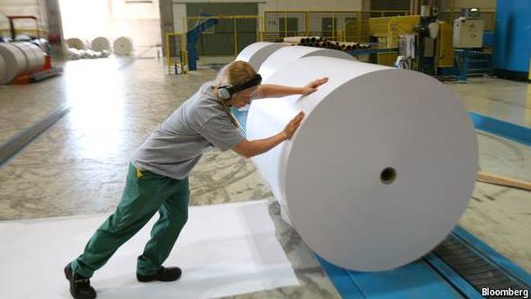
Roll On The Green Revolution. European pulp and paper companies have developed new technologies to dramatically lower CO2 emissions, as reported by
The Economist; here's a clip: "...
Even
so, several lessons have emerged. The main one is that there are
technological solutions to climate change. “We were amazed at what we
found,” says CEPI’s Marco Mensink. Some of the ideas not only cut
emissions but take energy-intensive firms into new areas—biochemicals,
in the case of pulp and paper. Next, companies can do lot about climate
change themselves. They do not need to wait for a nudge from
governments, although CEPI also wants the European Union to put some
money where its mouth is and support more basic research..." (Photo credit: Bloomberg).


No comments:
Post a Comment