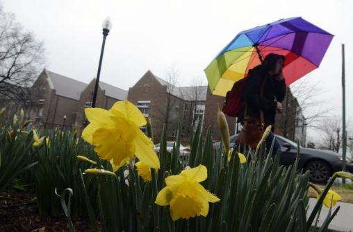
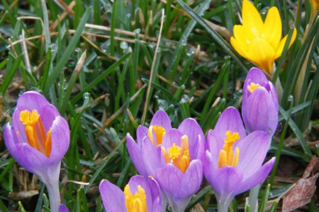
False Spring
"April showers bring May flowers". The prevailing wisdom is that spring rains cause flowers to bloom, on cue. But recent research suggests spring bloom times are more a function of temperature than moisture.
An article on today's weather blog (below) shows flowering times for 23 native species across Wisconsin have shifted from May 7 (1935-1945) to May 1 (1977-2012). The authors of the paper point out the rising incidents of "false springs", where unusually early surges of March warmth trigger premature blooms, only to be followed by hard, killing frosts & freezes.
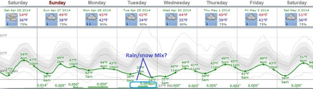
Gazing at the weather maps I'm wondering about our tenuous spring. Clouds increase today, a stiff east breeze with daytime highs stuck in the 50s - as mild as it's going to get looking out into next Thursday. Showers arrive Sunday; steadier/heavier rain Monday before a brief clearing trend Tuesday. A temporarily stalled storm "retrogrades", pinwheeling moisture back into Minnesota Wednesday/Thursday - precipitation approaching from the east!
It pains me to say this out loud, but the atmosphere may be marginally cold enough for a rain/snow mix Wednesday. Accumulation? Probably not.
ECMWF models show 60F the end of next week.
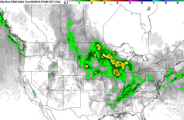
- We are preparing for a multiday severe weather threat starting tomorrow through next Tuesday. Sunday is looking to be the worst day of the bunch with a day 3 moderate risk already issued. Hail will be the main threat tomorrow, but Sunday will pose a threat for large damaging, long track tornadoes.
THE RIGHT MIX OF INGREDIENTS
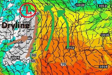
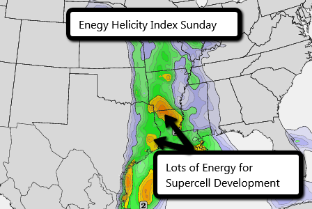
- Much like baking a cake, the perfect set of ingredients will come together this weekend allowing several days of severe weather to kick off. A low pressure system will form over the Rocky Mountains tomorrow afternoon and begin moving to the east stirring up severe weather. This will give the wind speeds and direction needed for severe supercell development. As you can see below, the low pressure will be pulling up warm moist air from the Gulf of Mexico while at the same time be driving the dryline east. This will create an explosive environment the next few days.
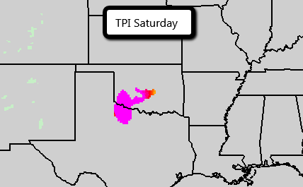
SATURDAY
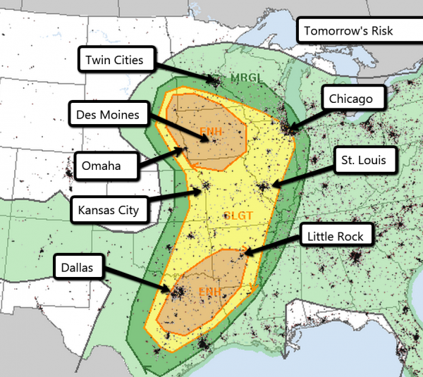
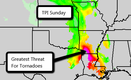
SUNDAY (POTENTIAL OUTBREAK DAY)
- Sunday is shaping up to be the most dangerous day during this severe weekend. It is believed by much of the meteorological community that what a weather system has done the previous days will tell you what can be expected about the current risk. So pay attention to what happens tomorrow and it may be a key as to what can be expected Sunday.
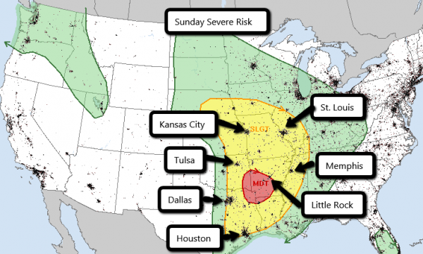
- When the SPC issues a moderate risk on day 3 it almost always means that a high risk will occur on the day of the storm.
- When a high risk is issued any watches in that area are required to be a PDS watch. PDS stands for Particularly Dangerous Situation. If you hear PDS mentioned you need to pay extra special attention to the weather that day.
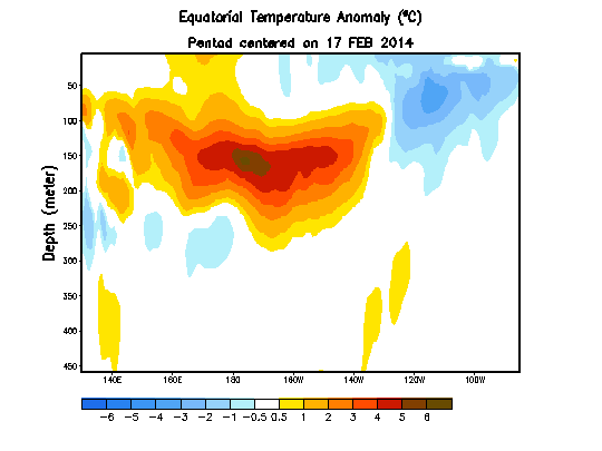
- The current large build-up and eastward movement of heat in the equatorial subsurface ocean strongly hints at a powerful El Niño developing this year.
- A powerful El Niño is by no means guaranteed, but should one develop mid-2014 to mid-2015 would likely be the hottest 12 months ever recorded. Unfortunately widespread weather-related chaos and mass coral bleaching is almost certain to follow.
62 F. high in St. Cloud Friday.
62 F. average high on April 25.
49 F. high on April 25, 2013.
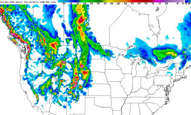
1.93" rain predicted for STC by Tuesday morning. 00z NAM model.
TODAY: Clouds increase, cool breeze. Drier day of the weekend. Winds: E 15. High: 53
SATURDAY NIGHT: Mostly cloudy with showers developing. Low: 38
SUNDAY: Showers likely. Windy and damp. High: near 50
MONDAY: Heavier, steadier rain likely. Wake-up: 39. High: 46
TUESDAY: Periods of rain, possibly mixing with wet snow. Wake-up: 35. High: 44
WEDNESDAY: Rain, possibly mixed with snow early. Wake-up: 33. High: 45
THURSDAY: Showers taper. Raw for May 1. Wake-up: 37. High: 48
FRIDAY: Peeks of sun, hints of spring return. Wake-up: 38. High: 51
Climate Stories....
Stanford Scientists: Climate Change Occurring 10 Times Faster Than Any Time In Past 65 Million Years.
It's the rate of greenhouse gas release and subsequent warming that has
climate scientists so concerned. Here's a clip from a story at desmogblog.com: "With
scant media attention, climate scientists from Stanford University have
concluded that climate change is occurring 10 times faster than at any
time in the past 65 million years, and the current pace of change will
lead to a 5-6 degree (Celsius) spike by the end of this century. The findings come from a review of climate research by Noah Diffenbaugh, an associate professor of environmental Earth system science, and Chris Field, a professor of biology and of environmental Earth system science and the director of the Department of Global Ecology at the Carnegie Institution. Both scientists are senior fellows at the Stanford Woods Institute for the Environment. Their work is part of a special report on climate change in the current issue of Science..."
No comments:
Post a Comment