Most Underrated Month?
"By
all these lovely tokens September days are here, with summer's best of
weather and autumn's best of cheer" said Helen Hunt Jackson. Not that it
matters but this may be my favorite month of the year.
Think
about it: summer's frantic 90-day spasm of over-scheduling is over - the
air still mild; lakes warm enough for one last dip. Tornadoes are rare,
a cooling atmosphere sparks lazy clouds: wisps of dense fog.
NOAA
data shows September is nearly as sunny as July & August, 1-inch
rains half as common as June. The air has roughly half as much water
floating overhead as early July; crisp and clean most of the month. Even
the mosquitoes seem to get the hint. Summer's September encore is
nature's last standing ovation and I'm a raucous fan.
No need to
water the yard anytime soon after last night's noisy soaking. Showers
give way to some afternoon sun; the weather getting better as today goes
on. Not a perfect Labor Day but we've seen worse. The next chance of
thunder comes Thursday with a heat spike; highs may brush 90F before
tumbling to more comfortable levels late week. You may have to pull out a
sweatshirt next weekend.
In 2014 weather is on a time-delay; everything is coming later. I suspect a warmer than average September.
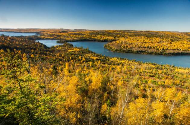
* File photo of Minnesota's BWCA courtesy of
Steve Burns Photography.
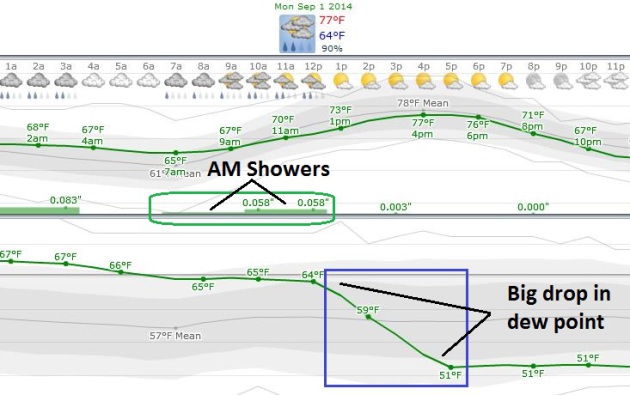
Labor Day Details.
European guidance shows a risk of morning and midday showers, but winds
switching around to the west/northwest should pull drier, more stable
air into MSP by afternoon with dew points falling from mid 60s into the
low 50s by evening. The odds of seeing the sun increase as the day goes
on.
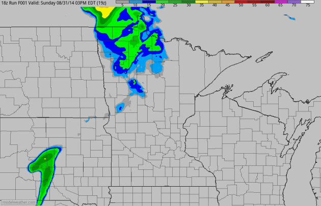
Future Radar.
4 KM NAM guidance shows the showers and T-storms that rumbled across
the area late yesterday and overnight; a few stragglers this morning
then drying out later in the day with enough sun for highs in the upper
70s. Loop: NOAA and HAMweather.
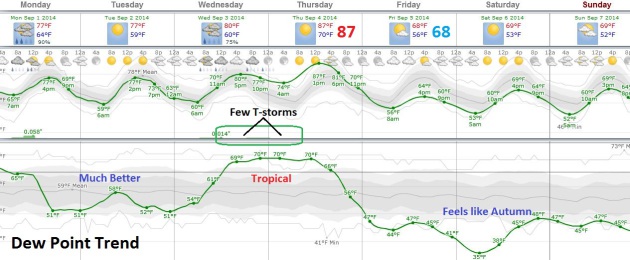
Big Swings.
We cool off and dry out today, a beautiful Tuesday giving way to a
quick midweek hot front; some guidance hints at upper 80s to near 90F by
Thursday with a few T-storms late Wednesday into Thursday. And then a
more September-like airmass comes south for late week. ECMWF data may be
overdoing the cooling a bit, but temperatures may struggle to reach 70F
in the metro Friday into Sunday with 60-degree highs up north.
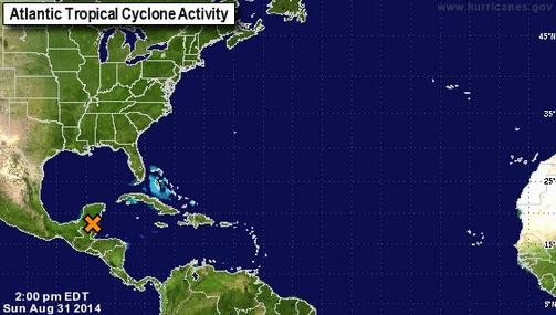
Traditional Peak of Hurricane Season Off To A Slow Start.
The Atlantic hurricane season peaks September 10, the day a landfalling
hurricane is most likely to strike the USA. But things remain strangely
quiet in the Atlantic and Carribean, and the short-term forecast is for
more of the same. Here's a clip from a story at
Florida Today: "...
But
on Aug. 27, a forecast team at Colorado State University released a
two-week forecast of hurricane activity through Sept. 10, predicting
below average activity. The team tries to predict what they call the
Accumulated Cyclone Energy (ACE) index. That’s all the named storms’
maximum wind speeds for each six-hour period of the storms that happen
over the two-week prediction period. They say the two weeks ending Sept.
10 will bring less than 70 percent of the average ACE..."
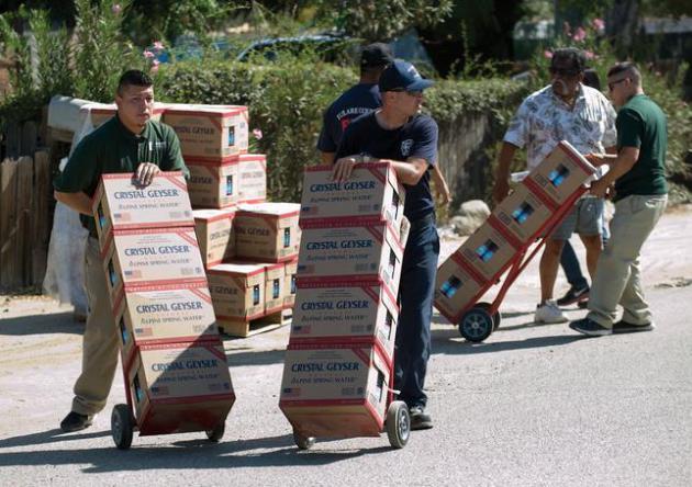
Drought Forces Big Changes Among California Growers.
If the drought continues we will all be paying significantly higher
prices for many vegetables. Here's an excerpt of a good summary of what
growers are doing to try and deal with historic drought at
The Seattle Times: "...
Such
crop switching is one sign of a sweeping transformation going on in
California — the nation’s biggest agricultural state by value — driven
by a three-year drought that climate scientists say is a glimpse of a
drier future. The result will affect everything from the price of milk
in China to the source of cherries eaten by Americans. It has already
inflamed competition for water between farmers and homeowners..."
Photo credit above: "
Volunteers
deliver cases of water to homes in East Porterville, Calif., Friday,
Aug. 22, 2014. Nearly 1,000 people whose wells have gone dry due to
drought received an emergency allotment of bottled water Friday." (AP Photo/The Porterville Recorder, Chieko Hara)
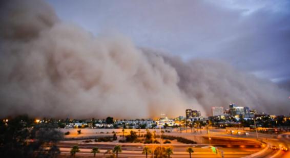
Swirls of Dust and Drama, Punctuating Life in the Southwest.
With all apologies to my TV meteorology friend in Phoenix, haboobs are a
clear and present danger, especially during the summer months. Here's
the intro to a story at
The New York Times: "
The
best way to explain a haboob is to say it is a tsunami of sand, in the
sense that there is no stopping it or outrunning it. It is a supreme
spectacle. The fierce winds that precede it make the leaves on palm
trees stand as if they are hands waving an effusive goodbye, the sky
darkens and the world takes the color of caramel as the dust swallows
everything in its path..."
Why You Need To Stop Checking Your Phone All The Time. Here's a snippet from an essay at
MindBodyGreen that caught my eye. She's right: "..
.I
do my best to put the phone away when spending quality time with
others, but because we all live in the same world and we all use these
devices, we all have the same strange addiction to them. We’re tolerant
of each other as we communicate
with everyone else but the ones we’re with. Beyond the very basic
tenants of memory we used to hold so dear (remembering phone numbers,
addresses, birthdays and details of loved ones, etc.), lies a direct
correlation between how much we use our brains and how much we
substitute them with our phones..."
LABOR DAY: AM showers, slow PM clearing. Winds: West 10. High: 76
MONDAY NIGHT: Clear to partly cloudy, more comfortable. Low: 54
TUESDAY: Partly sunny, less humid. Dew point: 55. High: 78
WEDNESDAY: Fading sun, storms at night. Wake-up: 57. High: 82
THURSDAY: Hot & sticky. Few T-storms. Dew point: 70. Wake-up: 68. High: 87
FRIDAY: More clouds than sun, cooling off. Wake-up: 57. High: near 70
SATURDAY: Sunny and beautiful. Dew point: 42. Wake-up: 50. High: 69
SUNDAY: Intervals of sun, hints of fall. Wake-up: 51. High: 71
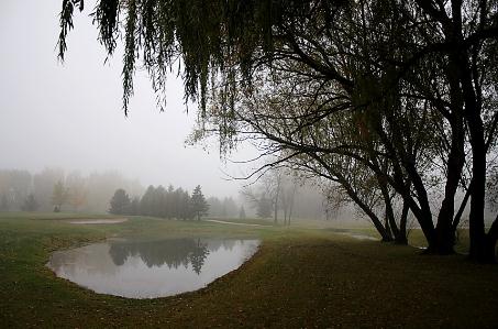
* File photo above: Brad Birkholz.
Climate Stories...
David Hastings: What I didn't Say to Gov. Scott About Climate Change. Here's a clip of an Op-Ed at
The Tampa Tribune: "...
The
governor’s office should embrace a transparent process to develop and
implement a state plan to reduce carbon pollution. Florida should:
♦
Phase out coal-burning power plants. Many of these plants are
inefficient, and they are the biggest source of human CO2 emissions.
♦
Ramp up energy efficiency. It is the fastest and cheapest way to reduce
carbon emissions. Setting meaningful efficiency goals for big utilities
will save communities money and reduce harmful emissions of
heat-trapping gases..."
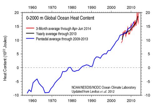
Climate Change Critics Want Data, Then Ignore It. An Op-Ed in the
Union-Bulletin
summed up something I've personally experienced, especially as it
relates to the so-called "pause" in warming. Over 90% of the additional
warming is going into the world's oceans - it's not a model, actual deep
ocean temperature increases have been observed. Here's an excerpt: "...
The
longer-term trend, averaged over many cycles, is for unremitting
increases in temperature. The effects of deeper layers of the oceans
periodically absorbing heat isn’t sustainable and may itself upset
oceanic currents that moderate temperatures around the globe. Scientists
acknowledge the need for more data and improvements in their analytic
methods. But, it is disingenuous of critics to ask for data, and then
ignore what they are shown. They have no data themselves and their
armchair methods aren’t likely to produce any."
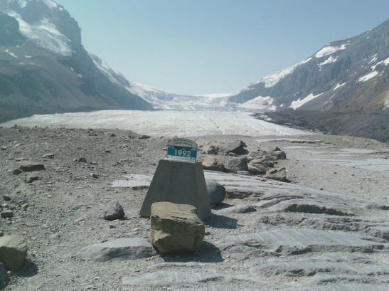
Athabasca Glacier: A Tragic Vanishing Act. Here's the introduction to a story at Skeptical Science and
Critical Angle: "
The
Athabasca Glacier in the Canadian Rocky Mountains is probably the
easiest glacier in the world to access by car. It’s just a few hundred
metres’ stroll from the nearest parking lot on the magnificent Icefields Parkway in
Alberta. The problem is, the stroll keeps getting longer by about 10
metres every year. Since 1992, the snout of the glacier has retreated
about 200 metres, requiring tourists anxious to set foot on the glacier
to walk a little further. The glacier has lost about 2 km of its length
since 1844 (Geovista PDF)..."
Photo credit above: "
The
Athabasca Glacier seen from the access trail. This point is about
halfway from the parking lot and the current snout of the glacier, which
is about 200 metres away. In the centre background is the ice-fall from
the Columbia Icefield. The marker shows where the glacier snout was in
1992, coincidentally the year of the Rio Earth Summit. It is just possible to make out some people walking on the glacier on the left-hand side."
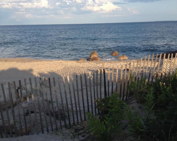
Beachfront in the Time of Climate Change. The Atlantic's
Citylab has a poignant article of what we will soon miss; here's an excerpt: "...
But
this year, as everybody packs up and heads back to school in the ritual
of Labor Day Weekend, there’s something sinister about being near the
water. It’s an end-of-days feeling, the grim reality that, because of
climate change, these places are going to be very different in 30 to 50
years. Vast acreage will be inundated. Many of the most sought-after
houses on the coastline will be erased from the landscape..." (Photo credit: author Anthony Flint).
Managing Coasts Under Threat from Climate Change and Sea Level Rise. Is there an orderly, methodical way to gradually retreat from the oceans? Here's a clip from a story at
phys.org: "...
The
scientists also acknowledged that long-term adaptation to climate
change can greatly reduce impacts, but further research and evaluation
is required to realize the potential of adaptation. "Many parts of the
coast can, with forward planning, adapt to sea-level rise, but we need
to better understand environments that will struggle to adapth, such as
developing countries with large low-lying river deltas sensitive to
salinization, or coral reefs and particularly small, remote islands or
poorer communties," said Dr. Brown..."
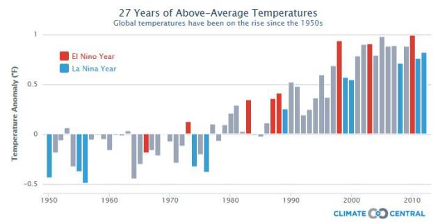
1 in 4 Republicans Say Global Warming is a Major Threat.
The Daily Caller has highlights of a recent Pew research study.
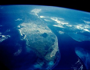
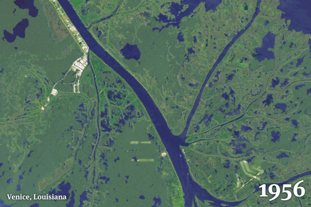
As Louisiana Sinks and Sea Levels Rise, The State is Drowning. Fast. Here's an excerpt from
Huffington Post that caught my eye: "...
In
just 80 years, some 2,000 square miles of its coastal landscape have
turned to open water, wiping places off maps, bringing the Gulf of
Mexico to the back door of New Orleans and posing a lethal threat to an
energy and shipping corridor vital to the nation’s economy. And it’s
going to get worse, even quicker. Scientists now say one of the greatest
environmental and economic disasters in the nation’s history is rushing
toward a catastrophic conclusion over the next 50 years, so far
unabated and largely unnoticed..."
Animation credit:
From Bob Marshall, The Lens, Brian Jacobs and Al Shaw, ProPublica:
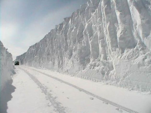
Why Climate Change Won't Intensify Extreme Snowstorms.
The most intense snowstorms may shift north over time, which isn't
surprising in a slowly warming world. Here's an excerpt from Live
Science and
Yahoo News: "...
The
study revealed little change in the intensity of major snowstorms in
wintry regions. In areas where winter temperatures hover near the snow
"sweet spot," the heaviest snowstorms became only eight percent less
intense. The higher latitudes will shift the other way, with 10 percent
more snow during extreme events, O'Gorman found. In regions where there
is usually little snowfall, there will be fewer days with history-making
storms..."

No comments:
Post a Comment