Sep-tober
A
year ago today it snowed in the Twin Cities, just a trace of flurries, a
high of 40F after waking up to 26F. This year temperatures are 20F
warmer; a few rain showers in the forecast later today.
Does that
imply a milder winter to come? You can't look out your window and make
an accurate 3-4 month forecast. As much as we all want to know, the
severity of winter cold and snow will depend on how fast El Nino can
warm up the Pacific Ocean, and blocking patterns over North America that
have yet to show up.
Weather rarely repeats itself from one year
to the next - everything I'm looking at leads me to believe this winter
won't be as rough as last, with more of a milder, Pacific flow than last
year.
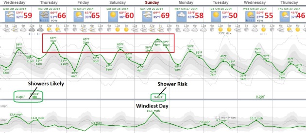
Winds pick up today ahead of a sloppy front; a few hours of
rain by tonight. Friday will feel like early September with a shot at
70F. Expect 70-degree warmth again Sunday before jackets return by
Tuesday. Next week's predicted weather map looks more like mid-September
than late October, dominated by a zonal, west to east wind flow. That
should mean 50s on Halloween.
I expect a mild bias to spill over into at least mid-November. After that? "Partly to mostly with a chance."
When in doubt, mumble.
But Wait, There's More!
If you've been living in a cave, not noticing how amazing the month of
October has been in Minnesota, you're in luck - because more Indian
Summer is brewing later this week into the weekend. I wouldn't be
surprised to see highs near 70F Friday, maybe low 70s Sunday. The best
chance of a little rain comes tonight, a fleeting shower Sunday before a
more October-like airmass arrives early next week. Graphic:
Weatherspark.
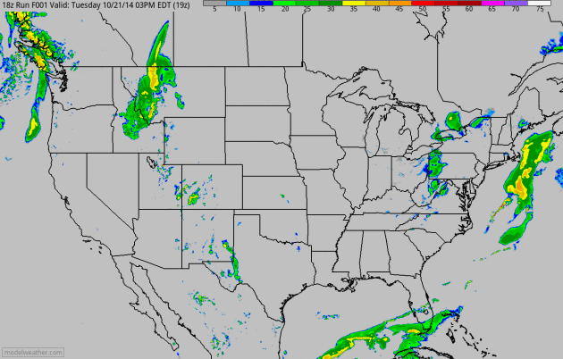
Future Radar.
As a nor'easter wraps up over New England, moisture-laded winds blowing
off the Atlantic dropping some 2-4" rains capable of flash flooding.
Heavy rain pushes into the Pacific Northwest, while a weak frontal
boundary drags a few hours of showers into Minnesota by tonight. 60-hour
accumulated rainfall forecast: NOAA and HAMweather.
A Retreat From Weather Disasters.
There is no constitutional right to property insurance or flood
insurance. What happens when enough insurance companies reach the
conclusion that risks are just too high to insure specific communities?
It's already happening, as reported by
The New York Times; here's an excerpt: "...
As
the damages wrought by increasingly disruptive weather patterns have
climbed around the world, the insurance industry seems to have quietly
engaged in what looks a lot like a retreat. A report to be released
Wednesday by Ceres,
the sustainability advocacy group, makes the point forcefully. “Over
the past 30 years annual losses from natural catastrophes have continued
to increase while the insured portion has declined,” it concluded. Last
year, less than a third of the $116 billion in worldwide losses from
weather-related disasters were covered by insurance, according to data
from the reinsurer Swiss Re..."
What's Behind Recent Flurry of Hurricane Activity?
Here's a particularly good explanation of the MJO and how this signal
can impact hurricane formation in the tropics, courtesy of Scientific
American and
oceanleadership.org: "...
So
a sort-of El Niño plus a suppressive MJO phase equaled a quiet
September. But now, the enhanced phase of the MJO has come into the
area, and it’s been a particularly strong one, Blake said. “We’ve seen
this type of thing happen before, it’s just rare,” he said. The boost
from the MJO has helped give storms a friendlier atmospheric environment
in which to form, while ocean temperatures are still warm enough. “It’s
still October, and October’s a pretty busy month for hurricanes, and
the Atlantic’s still plenty warm,” Blake said, though he added that the
busiest October pales in comparison to the busiest September..."
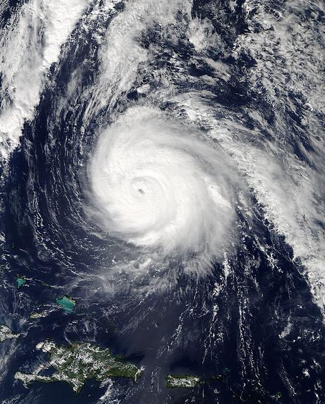
Image credit above: "
On
Oct. 16 at 17:45 UTC (1:45 p.m. EDT) NASA’s Aqua satellite captured
this image of Hurricane Gonzalo (08L) in the Atlantic Ocean." (Credit: NASA Goddard MODIS Rapid Response Team)
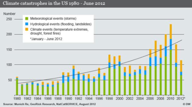
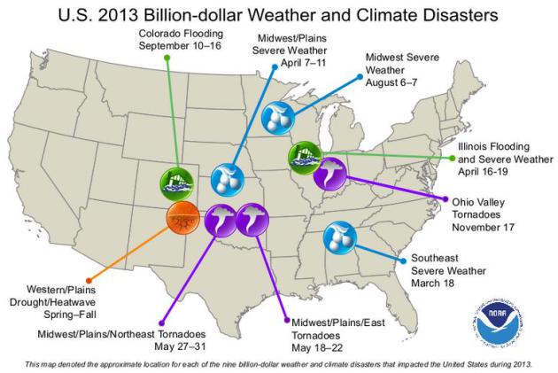
Billion Dollar Weather/Climate Disasters: Overview. Here's an excerpt from
NOAA NCDC: "
Found
here are the weather/climate events that have had the greatest economic
impact from 1980 to 2013. The U.S. has sustained 170 weather/climate
disasters since 1980 where overall damages/costs reached or exceeded $1
billion (including CPI adjustment to 2013). The total cost of these 170
events exceeds $1 trillion. In 2013, there were 9 weather/climate
disaster events with losses exceeding $1 billion each across the United
States. These events included a drought event, 2 flooding events, and 6
severe storm events. Overall, these events resulted in the deaths of 113
people and had significant economic effects on the areas impacted..."
El Nino Brings Floods, Risks, and Opportunities.
Even a mild El Nino warming phase of the Pacific (which still looks
likely) might tilt the odds over in favor an average or slightly milder
than average winter. There are other consequences of this warm phase;
here's an excerpt from
Climate Central: "...
Those
patterns reflect the broad changes El Niño, known more fully as El
Niño-Southern Oscillation or ENSO, generally causes to precipitation
patterns globally. The warming of water in the eastern equatorial
Pacific that characterizes El Niño tends to shift the odds of
precipitation in certain places around the globe, though it by no means
guarantees it. “There have been studies (showing) that some areas
get more rainfall during El Niño years, but more rainfall doesn’t
necessarily mean more floods. So we’re looking at the actual flooding
and damages caused by flooding,” Ward said..."
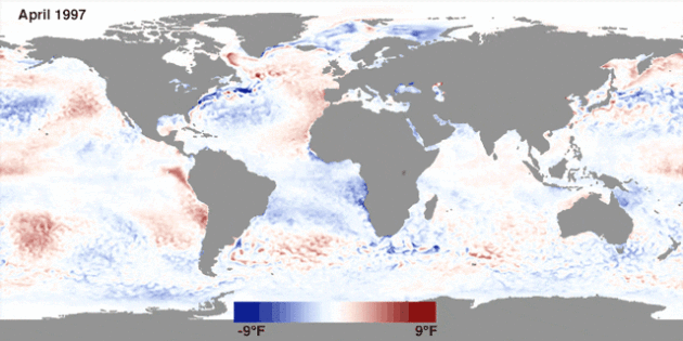
Animation credit above: "
A map showing sea surface temperature anomalies leading up and during the 1997-98 super El Nino." Credit: NOAA View
El Nino Ups Flood Risk. Scientific American
has more details on the recent report, highlighting where flood/drought
tends to spike during El Nino warming phases in the Pacific; here's a
clip: "...Ward and his colleagues found that 44 percent of
river basins around the world saw changes in 100-year flood risks during
El Niño or La Niña years, with some seeing higher risk of floods and
loss of property and some seeing lower risk. The Southwest U.S., parts
of southern South America and the Horn of Africa saw some of the biggest
increases in flooding risks while the West Coast, Sahel region of
Africa and Australia saw the biggest decreases..."
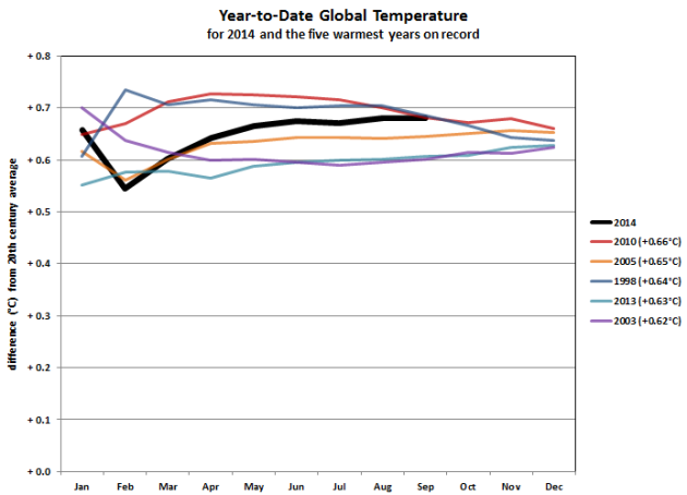
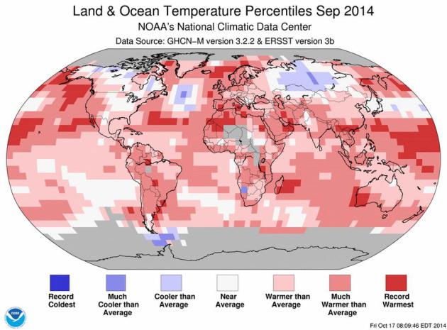
2014: On Track for Warmest Year, Worldwide, on Record.
Global temperatures are on track for the warmest year, worldwide, since
the late 1800s. What makes this especially noteworthy is a lack of an
El Nino warm phase (yet), a warm stain of Pacific water tends to
turbocharge air temperatures downwind as well, but we've been in an
ENSO-neutral phase for much of this year. A worldwwide "temperature
pause"? Not so much. Here's an excerpt from
NOAA NCDC: "...
The
graphic (above) shows the basic year-to-date comparison. The graphic on
the right zooms even further to what were ultimately the five warmest
years on record, and shows several end-of-year results based on the
following scenarios: The years 2013 and 2014 are the only years on this
list not to begin during a mature El Niño event. The years 1998 and
2010, each of which became the warmest year on record at the time, ended
the year in a strong La Niña event, as evidenced by the relative fading
of global average temperature later in the year...."
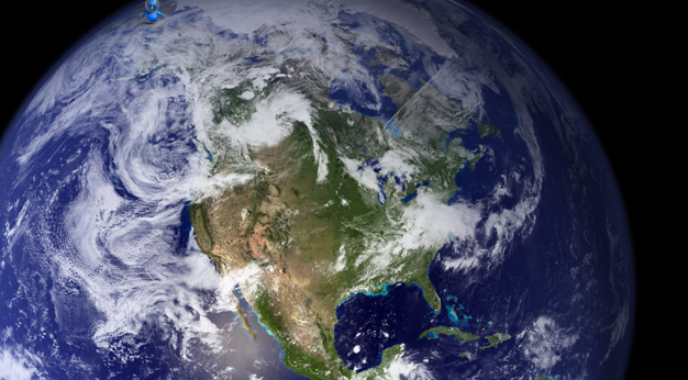
2014 On Track To Be Hottest Year On Record, Says U.S. Science Agency.
The 10 warmest years, worldwide, have all been measured since 2000.
Following up on the post above here's a clip of a good summary from
The Guardian: "
The
world is on course for this to be the hottest year ever, with global
land and sea temperatures for September the highest ever recorded for
the month, the National Oceanic and Atmospheric Administration said on
Monday. The findings,
which confirm September as the warmest such month on record, continue a
string of record-beating months for global temperature. The year to
date for 2014 is already tied with 1998 as the warmest such period since
record keeping began in 1880, Noaa scientists said..."
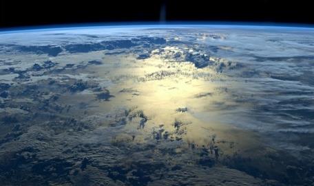
Image credit above: "
U.S. agency NOAA said: ‘If 2014 maintains this temperature departure from average... it will be the warmest year on record." Photograph: ISS/NASA.
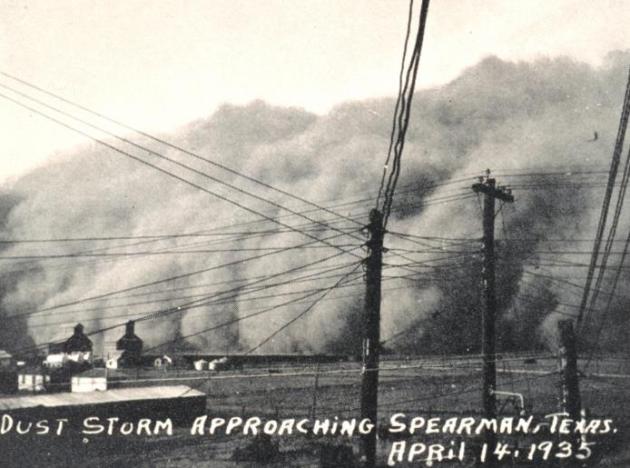
1934 Drought In Dust Bowl Days Was Worst in Thousand Years for U.S.: NASA. Here's a clip from a story at NBC News that made me do a double-take: "The
drought of 1934 wasn’t just bad, it was the worst. That’s the finding
of a reconstruction of North American drought history over the past
1,000 years, done by scientists from NASA and Columbia University’s
Lamont-Doherty Earth Observatory. Their study, to be published in the
Oct. 17 issue of Geophysical Research Letters, concludes the drought of
1934 during the Dust Bowl years in the North American Plains was 30
percent more severe than the next worst, which occurred in 1580, NASA said. The scientists used tree ring records from 1000 to 2005 along with modern observations..." (Image:
Wikipedia).
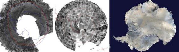
"Lost" Satellite Photos Reveal Surprising Views of Earth in the 1960s.
This is fascinating, providing a sobering look at the rate of change of
changes taking place on the planet's surface; here's an excerpt from National Geographic News: "The
trove includes the first publicly available satellite photos of Europe,
the earliest aerial views of Antarctica's ice, and a record of Central
Asia's Aral Sea before it dried up.
There's also a rare photo of the most powerful storm to hit North
America in modern times. The images, when compared with recent satellite
photos, show how humankind has changed the planet, from deforestation
to changes in sea ice..."
Image credits above: "
Scientists
scanned nearly 40,000 images taken from Nimbus 1 to create the earliest
satellite views of Antarctic sea ice and land (left and center). Using
computer programs to pick out ice-covered areas was much more
challenging than when using modern satellite images (right)." Photographs by (left and middle) NSIDC; (right) NASA/Reuters.
*
EarthSky
has an image of the first documented 5th order rainbow, sunlight
reflected 5 times within raindrops, creating a fairly amazing optical
illusion.
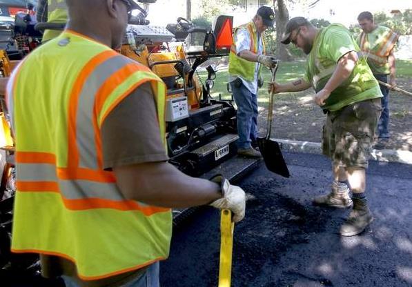
Street Rules: The Little Known Story of Pavement. I thought this article at
The Gazette
in Cedar Rapids, Iowa did a good job of laying out the differences (and
advantages) of concrete vs. asphalt highways, and the impact the
weather has on trying to keep roadway surfaces in good shape. Here's a
clip: "...
More challenging is what’s known as freeze-thaw cycles.
For example, the temperature warmed from 4 degrees on Jan. 18 to 42
degrees on Jan. 19. “Other parts of the country get freeze-thaw, but the
Midwest is the part of the country where we get the extremes — the very
cold, deep frost, and then the thaw and moisture,” Brakke said. “We
also have to deal with high temperatures that are hard on asphalt.”
Iowa’s soil also complicates matters for pavement because it holds water
rather than letting it run through. Engineers work hard to get water
away from the pavement, so it doesn’t freeze, crack and cause potholes..."
Photo credit above: "Paul
Colbert hands a shovel to Alex Foarde to clear fresh asphalt off of a
manhole cover as Cedar Rapids Street Maintenance workers repair
Meadowbrook Drive SE from flood-related damage in Cedar Rapids on
Wednesday, October 08, 2014." (Sy Bean/The Gazette).
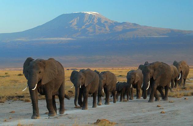
Elephants Able To Detect Rainstorms 150 Miles Away. Forget Doppler, I'm buying an elephant. Here's the intro to an explanation at
Popular Science: "
Lions
may be the kings of the animal world, but at least elephants could make
for spunky meteorologists. New research is revealing that elephants
have a radar-like spidey sense, capable of detecting an approaching
rainstorm up to 150 miles off. While this may seem like an impractical
talent, researchers say elephants' weather-predicting could help human
conservationists save the animals from poachers. The elephants’
abilities are rooted in their excellent hearing skills..." (File photo:
Wikipedia).

A U.S. Court Thinks The Most Famous Song in History Might Be Stolen.
Was "Stairway to Heaven" an original Led Zeppelin masterpiece, or
borrowed in bits and pieces from another band that opened for the
legendary rockers a long time ago. Here's the intro to a story at
Music.Mic: "
Everything
you know about classic rock music history may be a lie, according to
one federal lawsuit. Years ago, a relatively unknown '70s band called
Spirit accused Led Zeppelin of stealing the famous opening riff to
"Stairway to Heaven" from Spirit's song "Taurus." The claim was mostly
overlooked at the time, but now descendants of Spirit's founders have
taken the accusation to a Pennsylvania court, where the surviving members of Led Zeppelin are being tried for the "falsification of rock history...."
All I Want For Christmas This Year.
Our prayers have been answered - guys, if you're searching the interweb
for comfortable, waterproof (!) chinos, you are in luck. Details from
Gizmag: "
YOU
might think it's a little strange to be leaving a review for a pair of
golf trousers. Then again, not every pair of chinos are designed 100%
waterproof. Welcome to the new PING Typhoon waterproof trousers, which
in my honest opinion are the most comfortable pair of slacks I've ever
worn out on the course. I love them so much in fact, I wear them around
the house and even take them out on the town. At the heart of the
Typhoon chino is Sensor Dry technology and that provides guaranteed
waterproof and wind resistant protection..."
60 F. high in St. Cloud Tuesday.
54 F. average high on October 21.
39 F. high on October 21, 2013, with a trace of snow (flurries).
October 21, 1938: Sleet and wind causes damage along Minnesota/Wisconsin border. 100,000 dollars in damage at La Crosse.
October 21, 1913: Long Prairie had a record low of a chilly 8 degrees Fahrenheit.
TODAY: Clouds increase, late PM showers. Winds: S 15+ High: near 60
WEDNESDAY NIGHT: Showers likely. Low: 50
THURSDAY: Damp start, then slow clearing, still mild. High: 66
FRIDAY: Lukewarm sunshine. No complaints. Wake-up: 38. High: 68
SATURDAY: Sunny, slightly cooler breeze. Wake-up: 42. High: 62
SUNDAY: Summer in late October. Sunny and warm. Wake-up: 43. High: 68
MONDAY: Unsettled, isolated shower possible. Wake-up: 44. High: 56
TUESDAY: Mix of clouds and sun, cool breeze. Feels like October again. Wake-up: 33. High: 49
Climate Stories...
Climate Records Are Breaking So Often Now, We've Stopped Paying Attention. Chris Mooney has the story at
The Washington Post; here's an excerpt: "...
On Monday, we learned
from the National Oceanic and Atmospheric Administration that last
September was the hottest of them all, out of 135 Septembers going back
to 1880.The same was true for August 2014. And June of 2014. And May of 2014.
What that means is that for each of these months, the combined average
global land and ocean surface temperature has never been higher, at
least since we started recording these temperatures back in the
presidency of Rutherford B. Hayes..."
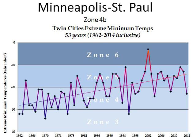
Coldest Winter Temperatures at MSP Since 1962.
Jack Falker is an investment banker (Falker Investments) and prize rose
grower, based in Edina. He sent me a graph he completed, showing the
coldest nighttime temperatures every winter going back to 1962. Of couse
this makes a difference in what will grow in the Twin Cities, an even
specific varieties of roses that are more cold-tolerant. In spite of
last winter's big dip you can clearly see the trends. As a rule, winter
temperatures are not as cold as they were 30-50 years ago, especially
nighttime lows. Here's an excerpt from Jack's latest post: "
The Minnesota Rose Gardener: Winter Protecting Roses in a Climate-Change Environment: "...
(above)
is my recently updated Minnesota climatology chart showing the Extreme
Minimum Temperatures (EMT) for the last 53 years at MSP airport. This
is the statistic the USDA uses to determine the cold zones. As you can
see, the Twin Cities are no longer consistently in USDA Zone 4b. As a
matter of fact, there have only been three nights in Zone 4 in the Twin
Cities, since 1999! That hardly puts us in Zone 4 and, as you can see,
the mathematically determined trend-line has an upward slope of about 25
radian degrees. If you project that trend-line off the right side of
the chart, it would appear that the Twin Cities will begin to see more
winters in zone 6 than in zone 4, within the next five years..."
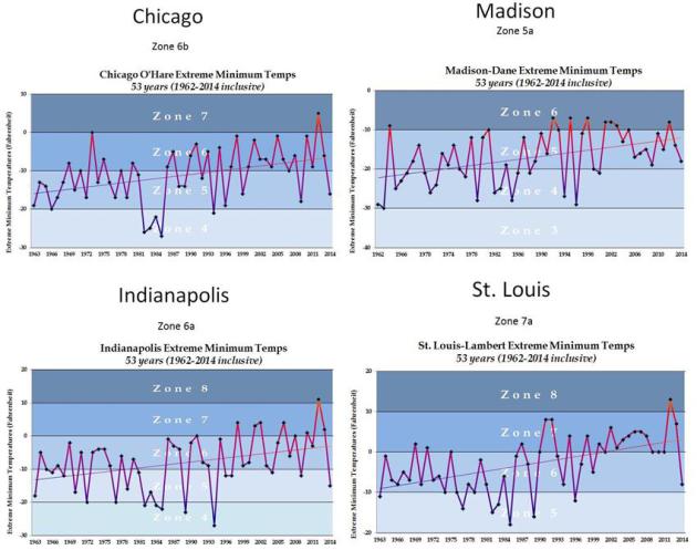
Similar Trends.
Jack Falker created similar graphs for other cities across the Midwest
and Great Lakes, and found a similar warming trend over time. Nature
never moves in a perfectly straight line, but if you draw a smoothed
line over the actual observations you can see the trends fairly clearly.
Which underscores something I tell people in my talks: don't look at
your thermometer for day to day evidence of warming. Look at the new
plants, shrubs, flowers, trees (and pests) that in your yard that
weren't there 40 years ago.
East Coast, Gulf Coast Should Get Used to Tidal Floods. Here's a snippet of an Op-Ed at
CNN: "...
Global
sea levels rose approximately 8 inches from 1880 to 2009 as global
warming hastened land-based ice melt, and seawater expanded as it
absorbed heat from a warming atmosphere. Sea level rise worldwide is now
accelerating, and at an especially fast rate along parts of the East
Coast. This reality is captured in a report we co-authored
earlier this month, analyzing how often flooding occurs at 52 sites
along the Eastern seaboard and the Gulf of Mexico and estimating the
frequency and extent of flooding over the next 15 and 30 years. We found
that many East Coast communities now experience dozens of tidal floods
every year. In some places, there has been a fourfold increase in the
number of days per year with tidal flooding since 1970..."
Another Month, Another Global Heat Record Broken. Will
2014 break another record? It's still a little early, but if the warm
weather departures we've been tracking in recent months continue the
answer is probably yes. Here's an excerpt from AP and
Huffington Post: "...
If
2014 breaks the record for hottest year, that also should sound
familiar: 1995, 1997, 1998, 2005 and 2010 all broke NOAA records for the
hottest years since records started being kept in 1880. "This is one of
many indicators that climate change has not stopped and that it
continues to be one of the most important issues facing humanity," said
University of Illinois climate scientist Donald Wuebbles..."
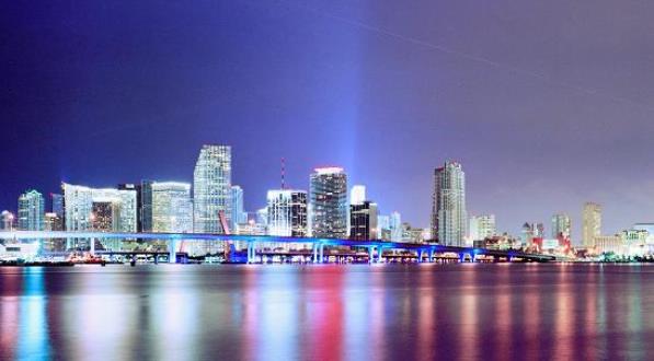
How Climate Change Is Fueling The Miami Real Estate Boom.
Bloomberg Businessweek has the story - here's a clip: "...
Where
locals disagree with outsiders, however, is about how best to deal with
the problem. Rather than sounding alarms and cutting back on
development, there’s an implicit sense that the best approach may be,
ironically, to do the opposite. And while a strong case can be made that
this behavior has no rational basis, it may represent Miami’s best
long-term hope for dealing with the threats posed by climate change, one
that other cities might be advised to mimic: The best strategy, in
fact, may be to foster a collective belief that there’s no threat—or at
least not one serious enough to lose sleep over..."
Photo credit above:
Trip Advisor.
Science The Benchmark of an Educated Society. Here's an excerpt of an Op-Ed at
The Sydney Morning Herald that resonated: "...
Science
provides a way of thinking. It encourages a healthy dose of skepticism
and offers a guide on how to evaluate false claims made by politicians,
advertisers, business, and almost anyone selling anything. Scientists
aren't the only ones who need to know how to spot pseudoscience – think
of popular diets and therapies such as paleo, clean eating, superfoods
and homeopathy. In this information age, where Professor Google has
become the expert of choice, being scientifically literate is an
essential life skill. It is as important as reading and writing..."
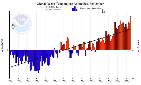
World's Oceans Set All-Time Heat Record for Third Time This Year. Meteorologist Andrew Freedman has the story for
Mashable; here's an excerpt: "...
For
the third month this year, the world's oceans set a record for the
warmest they have ever been since at least 1880, the National Oceanic
and Atmospheric Administration (NOAA) reported
on Monday. September had the highest global average sea surface
temperatures of any month on record since instrument record-keeping
began, with a global average temperature of 61.1 degrees Fahrenheit.
This was warm enough to set another milestone that had already been set
two previous times this year; the average global sea surface temperature
was so warm in September that it broke the all-time record for the
highest departure from average for any month since 1880, at 1.19 degrees
Fahrenheit above average..."
Map credit: NOAA NCDC.
The Difficult Dance of the 2014 Climate Change Denier. Here's an excerpt of a
Huffington Post story: "...
To
continue to claim that climate change is a hoax would get them labeled
as crazy, but to fully accept climate science requires them to favor a
solution to this threat, which would make them pariahs to the Koch
brothers and other polluters who are spending millions of dollars
attacking their opponents. These candidates' climate science denial
becomes a reflection of a disturbing character trait - their
unwillingness to address a growing threat to Americans because the
possible solutions may affect their benefactors' profits. This crop of
candidates ignores increasingly urgent warnings from NASA, the National
Academy of Sciences, and nearly all other scientific bodies, simply to
appease their special interest supporters. Their dance is choreographed."


No comments:
Post a Comment