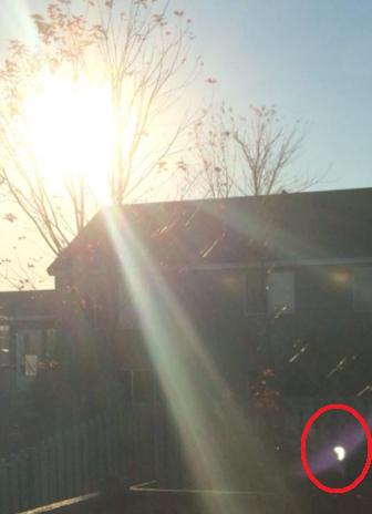
Here's the best I could do with Thursday's Partial Solar Eclipse in the Twin Cities. Note the glare in the bottom right corner of the picture; it's in the shape of Pacman - the glare is actually showing the partial solar eclipse!!
Wow Factor
By Paul Douglas
At the risk of editorializing, Friday will be an atmospheric balm from on high - more late August than late October. All those brave souls who kept their boats in the water an extra month will be smiling this afternoon. Expect blue sky, a soft breeze and 70 degrees by mid-afternoon, 20F warmer than average.
Kirk Dornfeld writes: "Can we truly call this current weather Indian Summer when we haven't yet had a killing frost? Or did I miss the frost?" The mercury at MSP International (the official reading) got down to 31F on October 11, with fairly widespread frost. The definition of Indian Summer is a little loose and subjective, but generally described as any warm days following the first cold weather or hard frost. Today fits that definition.
The weekend doesn't look too shabby with highs in the 60s spilling over into Monday, when a clap of thunder heralds the arrival of a cooler front.
Next week feels more like October, but nothing harsh is shaping up...yet. Expect Trick or Treat temperatures around 50F under a dry sky.
California may see a break in the drought; a colder/wetter pattern out west favoring a mild, Pacific flow for Minnesota. An Indian Summer November?
========
THURSDAY NIGHT: Partly cloudy, patchy ground fog. Low: 44
FRIDAY: Indian Summer returns. Perfect weather - warm sun. High: near 70. Winds: S 5-10
FRIDAY NIGHT: Partly cloudy and quiet. Low:44
SATURDAY: Plenty of sun, cooler breeze. High: 61
SUNDAY: Partly sunny, breezy. Clouds increase PM hours. Showers Sunday night. Low: 36. High:59
MONDAY: Mild sun, passing T-storm. Wake-up: 43. High:59
TUESDAY: Partly sunny, light jackets return. Wake-up: 43. High: 51
WEDNESDAY: Partly sunny and brisk. Wake-up: 32. High: 47
THURSDAY: Mix of clouds and sun. Octoberish. Wake-up: 30. High: 47.
==============
This Day in Weather History
October 24th
1922: Storm over Minnesota brings 55 mph winds at Collegeville.
=============
Average High/Low for Minneapolis
October 24th
Average High: 54F (Record: 80F set in 1989)
Average Low: 37F (Record: 15F set in 1887)
=============
Sunrise/Sunset Times
October 24th
Sunrise: 7:40am
Sunset: 6:13pm
==============
Moon Phase for October 24th at Midnight
1.4 Days Since New Moon

==============
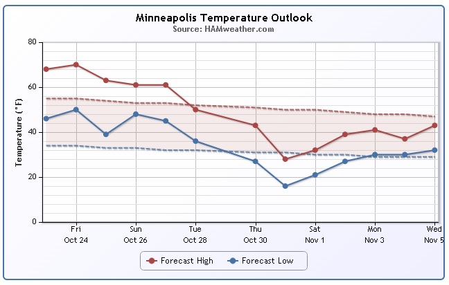
Minneapolis Temperature Trend
According to extended weather models, we could be in for a fairly decent chilly by the end of the month/early November. With that said, enjoy the next few days with mostly dry weather and highs in the 60s to near 70. Things begin to change early/mid next week as a large trough of low pressure works east. The first weekend of November could be a chilly one.
=================
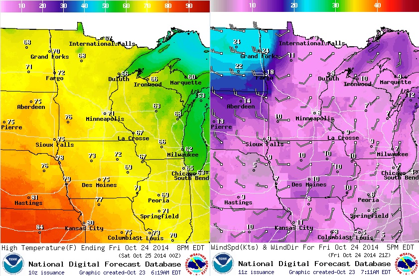
Friday Weather Outlook
WOW! Weather conditions on Friday look incredible! Highs in the 70s across much of the state with a mild southwest breeze. Clock out of work early if you can and soak up the sunshine. Cooler temperatures are on the way next week.
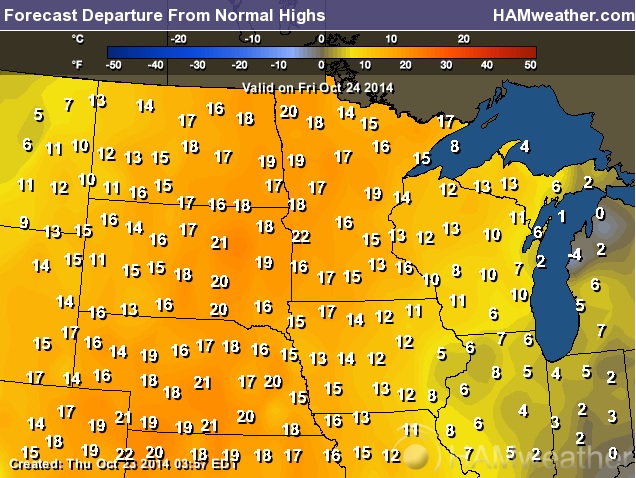
Friday Highs From Normal
Here's how much above average we'll be on Friday. Note that much of the Upper Midwest will be nearly 10F to 20F degrees above average!
Weather Outlook
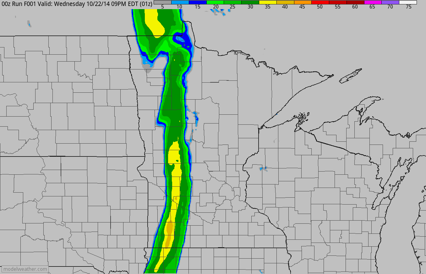
Say so long to the precipitation for a few days. The line of showers that moved through late Wednesday night/early Thursday morning is long gone and mostly dry weather will persist through much of the next several days
Average Snowfall for Minneapolis
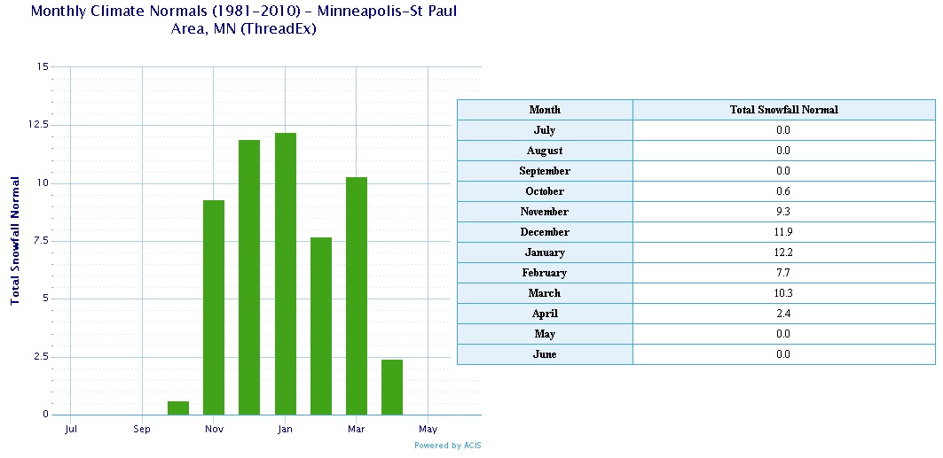
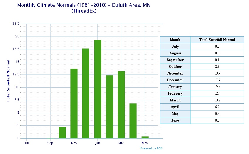
Whether you like it or not, we're not too far away from talking about snow. According to NOAA, the average (1981-2010) monthly snowfall for Minneapolis in October is 0.6" we have yet to see anything officially. However, Duluth, MN saw a trace of snow on October 3rd and 4th (Duluth averages 2.3" according to 1981-2010 averages). Interestingly, the average snow for November in Minneapolis and Duluth goes up significantly, Minneapolis typically sees 9.3" while Duluth averages 13.7". Thanks to my good friend and colleague D.J. Kayser, he found that the average 1" snow depth at Minneapolis is November 17th.
National Weather Outlook
Heavy rainfall in the Northeast will continue to taper through the end of the week. Weather conditions will improve greatly by the weekend as the storm system pulls away from the coast. There is also another very strong area of low pressure in the West that will continue to bring heavy rain to coastal communities through the weekend.
Heavy Rain in the Northwest
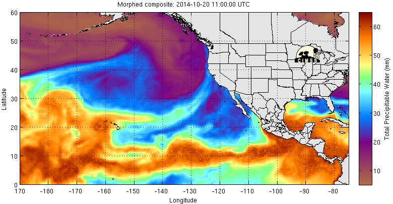
Portland, OR picked up 1.88" of rain on Wednesday, which makes in the wettest day in 2014 and the 3rd wettest October day on record since 1871. The loop below shows the precipitable water or how much moisture there is in the atmosphere and note the bright strip of heavier moisture that has positioned itself from north of Hawaii to the Pacific Northwest. This is part of the reason for all the heavy rainfall in the Northwest as of late.
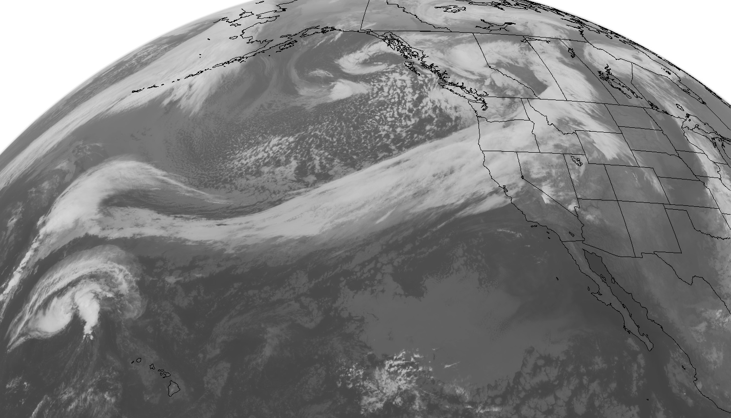
Heavy Northwest Rain
Here's a look at the satellite from earlier Wednesday, which shows a very large low pressure system in the Gulf of Alaska. The strong upper level winds are pulling a lot of this heavier moisture from tropics. Interestingly, some of the moisture headed into next week could be related to the remnants of Tropical Storm Ana that slid south of Hawaii last weekend.
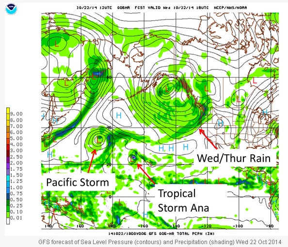
Remnants of Tropical Storm Ana to Affect the Pacific Northwest?
The National Weather Service has put together a nice blog explainer on how remnants from Tropical Storm Ana that slid south of Hawaii last weekend may have an effect on the Pacific Northwest by early next week.
Read more from the NWS HERE:
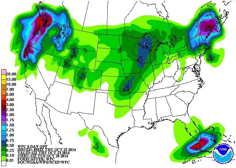
Rainfall Potential
According to NOAA's HPC, the 5 day rainfall potential suggests quite a bit of heavy rainfall across the West Coast from northern California to Washington!
U.S. Drought Monitor
The latest update from the U.S. Drought Monitor showed the worst of the drought still across the western U.S. with much of the EXCEPTIONAL drought across California.
"SUMMARY: The major weather system that affected much of the nation’s midsection last week left abundant precipitation this week from the mid-Atlantic up into New England. Hurricane Ana lost strength as it approached Hawaii and Tropical Storm Ana passed south of the Hawaiian Island dumping up to 10 inches of rain in its path."
"LOOKING AHEAD: During the October 22- 27, 2014 time period, precipitation is expected in the Pacific Northwest, southern Florida, and New England. Warmer than normal temperatures are expected throughout most of the interior of the nation. For the ensuing 5 days (October 28- November 1, 2014), the odds favor normal to above-normal temperatures across country with the exception of southeast Alaska. Above-normal precipitation is likely from the Pacific Northwest into the northern Great Plains and Upper Midwest, as well as in southern Florida and northwest Alaska. Below-normal precipitation is expected in a wide area from the Southwest through the Southern Plains and Southeast and up through the Lower Midwest and into the Mid-Atlantic and New England, as well as southeast Alaska."
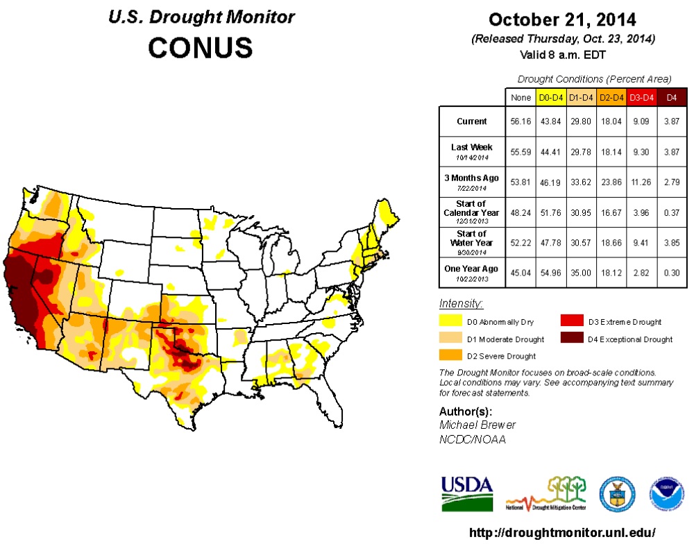
"Moisture fell in areas of the extreme Southwest and in the coastal areas of the Pacific Northwest this Drought Monitor week. As a result, areas of Moderate (D1) and Severe Drought (D2) were reduced in southwest New Mexico around Hidalgo County. Likewise the area of Extreme Drought (D3) was reduced in the northeast part of the state near San Juan County. There are numerous reports of improvement in pasture and grassland conditions but longer-term deficits remain over much of the state, resulting in conservative improvements. The same is true in the Pacific Northwest. Despite recent rains along the coast, long-term deficits are still being felt so improvement was held in check for another week. The rain has reduced the fire danger. As of October 17, only two large fires are burning in the country and they are both in California. To date, there have been 41,790 wildfires in 2014 that burned 3,070,737 acres. This is well below the 62,864 fire and 6,796,329 acre average of the last ten years (source: National Interagency Fire Center)."
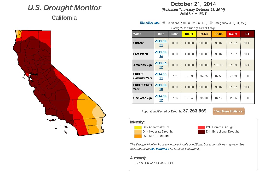
California Drought Continues
"Many areas in California have experienced three below normal rainfall seasons resulting in a reduction of reservoir levels, lowering groundwater levels, and drier than normal vegetation that has contributed to heightened wildfire concerns. In response to this, on January 17, 2014 California Governor Jerry Brown declared a drought state of emergency in California. The full text of the emergency proclamation can be accessed at: www.gov.ca.gov/news.php?id=18368
On April 25, 2014 Governor Jerry Brown issued an executive order to redouble the state drought actions. The full text of the executive order can be accessed at: www.gov.ca.gov/news.php?id=18496
Below is the U.S. Drought Monitor Map depicting drought conditions across the country as of September 23, 2014. This current map classifies 82% of California in extreme and exceptional drought and 58% of California in exceptional drought."
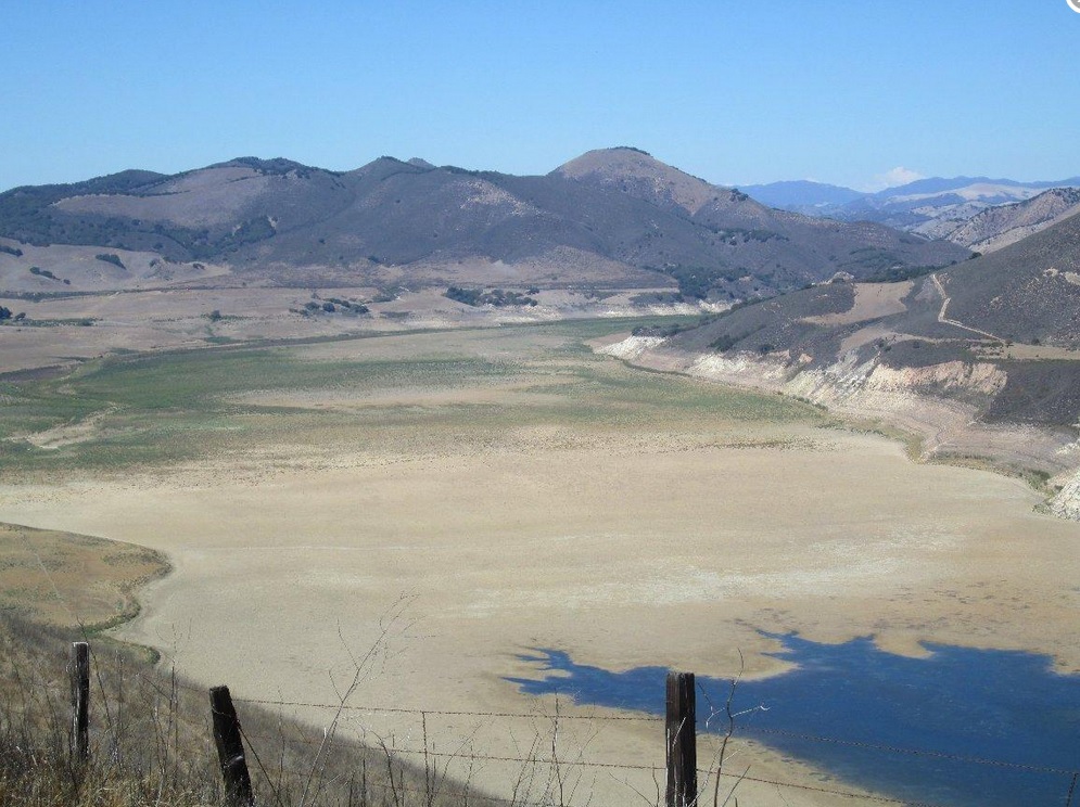
The National Weather Service has a great map and pictures of how the drought has affected southern California, see more HERE:
(Photo Credit NOAA)
Changes Ahead
Take a look at the 500mb vorticity (spin) map below for Friday and note the large ridge of high pressure that takes up most of the western U.S.. This ridge is pushing the upper level winds north along the International border, which will help to keep the colder air in Canada for now...
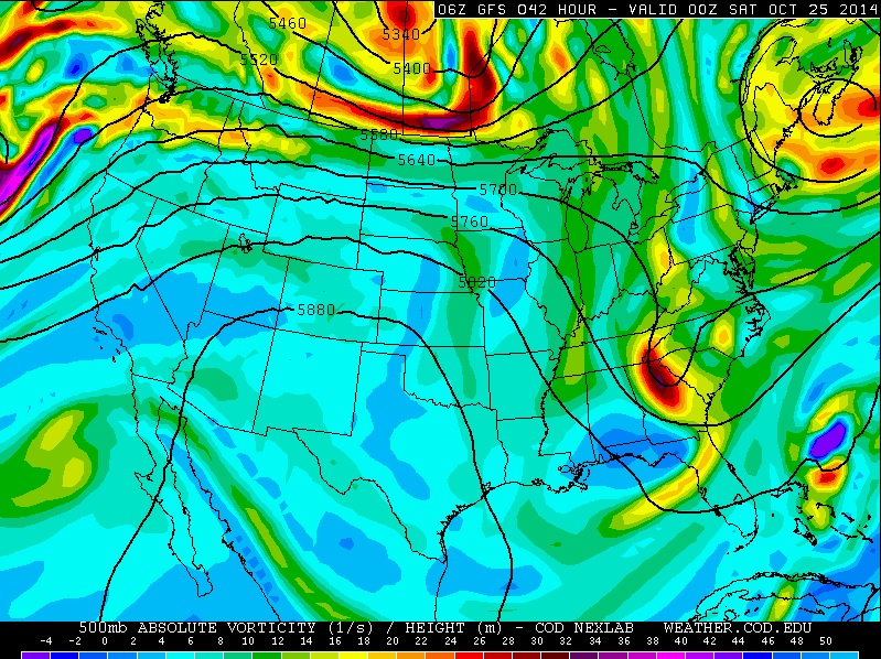
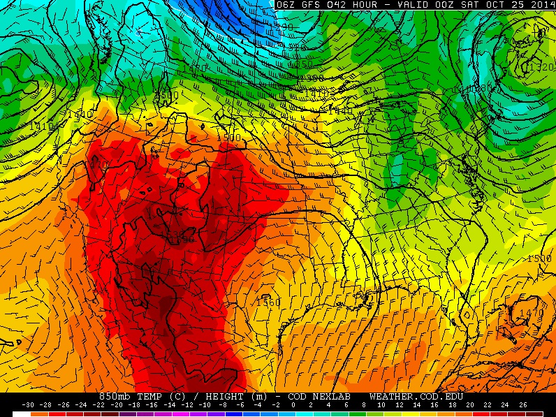
Here's the 850mb temperature outlook for Friday, which mimics that of the 500mb vorticity map above. Warmer weather corresponds with ridging in the western U.S., while cooler weather is kept in check across Canada.
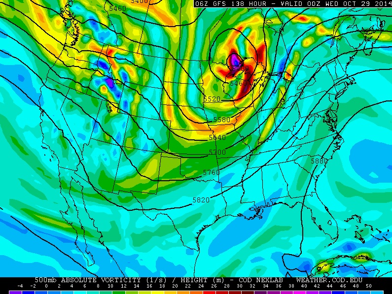
500mb Vorticity on Tuesday, October 28th
By early next week a fairly large trough of low pressure begins to settle into the Upper Midwest with much cooler temperatures along with it.
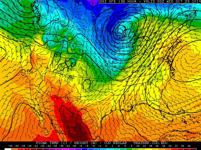
The 850mb temperatures outlook for Tuesday of next week mimics that of the 500mb vorticity map above, which shows a fairly decent pocket of cold weather heading south of the border along with that trough.
Thanks for checking in and have a great end of your week/weekend ahead! Don't forget to follow me on Twitter @TNelsonWX.

No comments:
Post a Comment