Big Swings
Think
back two years. The mercury soared to 60F on Thanksgiving Day, 2012.
That was the icing on the cake during Minnesota's warmest year on
record. This year? 45 degrees colder, give or take. But at least we
won't be shoveling out from under any untimely snowstorms. Not this
year.
Data since 1872 shows the odds of a subzero low Thanksgiving
morning are slightly higher than reaching 50F or above. There have been
only 9 subzero lows in the last 142 years; about 1 in 3 Thanksgivings
have at least an inch of snow on the ground.
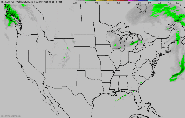
Sunday's 51-degree
instant thaw melted away most of the snow in the Twin Cities and I don't
see much new accumulation into Sunday. Wednesday's clipper may coat us
with an inch or so; another snowy coating possible Friday morning as
milder air pushes north.
Traveling out east for Turkey Day? As
much as 4-8 inches of slushy snow may fall Wednesday into early Thursday
from Philadelphia to metro New York & Boston. Great timing for the
busiest travel day of 2014. No controversy close to home - a thaw
Saturday, maybe 40s next Tuesday?
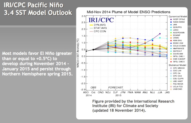
I expect more of a Pacific influence this winter as El Nino sets in, with lower odds of a stalled (frigid) polar block.
*
There's a good chance this will be the coldest Thanksgiving for the
Twin Cities since 1989, when the high was 18F, after waking up to 2F,
with 5" of snow on the ground. Data:
Minnesota Climate Office.
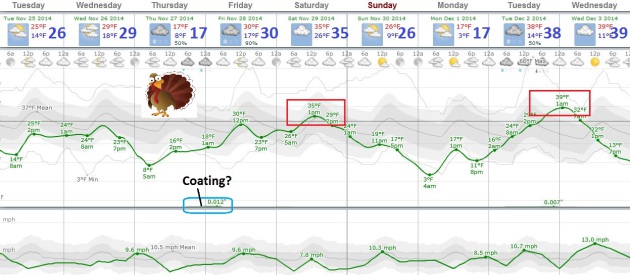
Cold, But Not Ridiculously So.
I still believe the next 2 weeks will be milder than the previous 2
weeks, as steering winds aloft alternate between Canadian and Pacific. A
blip of a thaw is possibly Saturday, again Tuesday and Wednesday of
next week when the mercury may climb into the 30s. Thanksgiving will be
nearly 20 degrees colder than average with fading sun and highs in the
teens; the approach of a milder front setting off a little light snow
Thursday night into Friday morning. No big storms are brewing. Graphic:
Weatherspark.
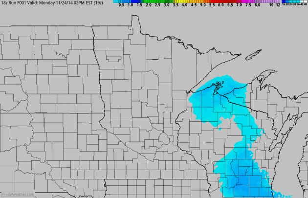
Wednesday Clipper.
The storm that brushed much of Minnesota with a coating of snow dropped
anywhere from 3-7" snow on Wisconsin, but conditions improve today as
skies clear. The next clipper pushes light snow across the Dakotas into
western and southern Minnesota late tonight into Wednesday, an inch or
two of accumulation possible tomorrow. 4 km NAM snowfall accumulation:
NOAA and HAMweather.
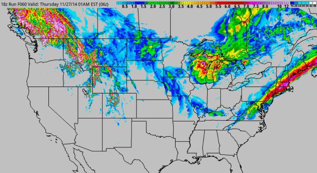
Stormy Bookends.
I'm seeing wetter trends materializing for California, more subtle
signs that a developing El Nino is pushing the Pacific storm track
farther south. A wet west coast increases the potential for a split flow
or zonal (west to east) flow materializing from time to time, taking
some of the edge off the arctic air. On Wednesday a coastal storm, a
classic Nor'easter, pushes coastal rain and heavy inland snow from near
Washington D.C. and Philadelphia into New England. Great timing.
Accumulation precipitation product courtesy of NOAA's 4 km NAM guidance.
Stripe of Heavy Snow Out East?
Tomorrow is the busiest travel day of the year, on average - a target
too tempting to resist for Old Man Winter. You can see the smear of
potentially plowable snow; everything shaded red at least 5" of
accumulation. 60-hour accumulated snowfall potential: NOAA and
HAMweather.
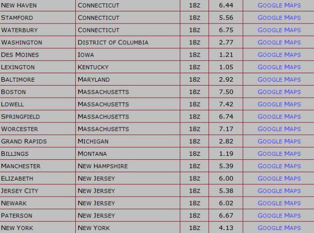
Preliminary Snowfall Totals.
Heading east for Thanksgiving? Light a candle and think pure thoughts
over the next 36 hours. If you fly out first thing Wednesday you have a
good shot of getting into D.C., New York or Boston. Late in the day? I'm
expecting widespread delays and cancellations as snow becomes heavier
and steadier. Amounts above courtesy of HAMweather.
Thanksgiving Day Climatology. Here's an excerpt of a post from the
Minnesota Climatology Working Group: "...
Looking
at the past 141 years, it is a little more likely to have a minimum at
or below zero on Thanksgiving Day, as it is to have a maximum of 50 or
above. Below-zero lows have occurred nine times in the past 141 years.
The coldest Thanksgiving Day minimum temperature was 18 degrees below
zero on November 25, 1880. The coldest high temperature was one below
zero on November 28, 1872. The last time it was below zero on the
morning of Thanksgiving was in 1985, with eight below zero..."
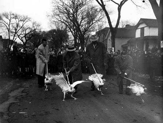
Photo credit: 1955 Turkey Race courtesy of the Minnesota Historical Society.
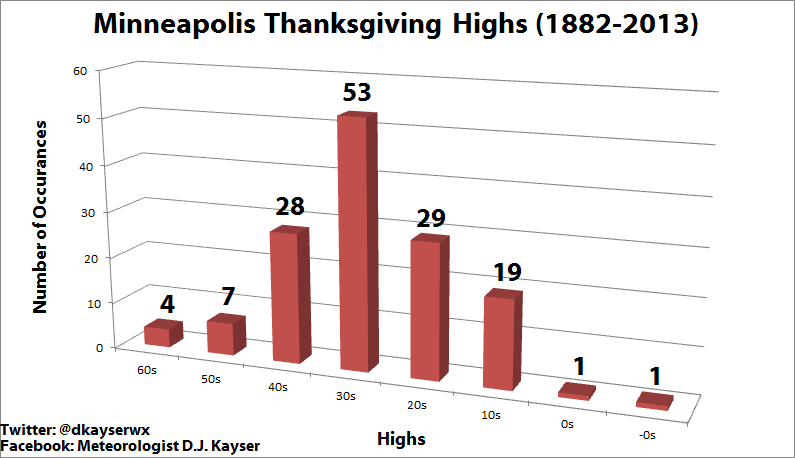 Distribution of Thanksgiving Day Highs Since 1882
.
Media Logic meteorologist D.J. Kayser put together a graphic putting
Turkey Day highs into perspective. It looks like this will be the 20th
Thanksgiving since 1882 with a high in the teens. For more good
historical information on Thanksgiving Day climatology in the Twin
Cities click over to his blog
here.
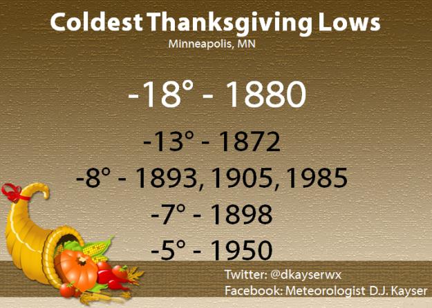
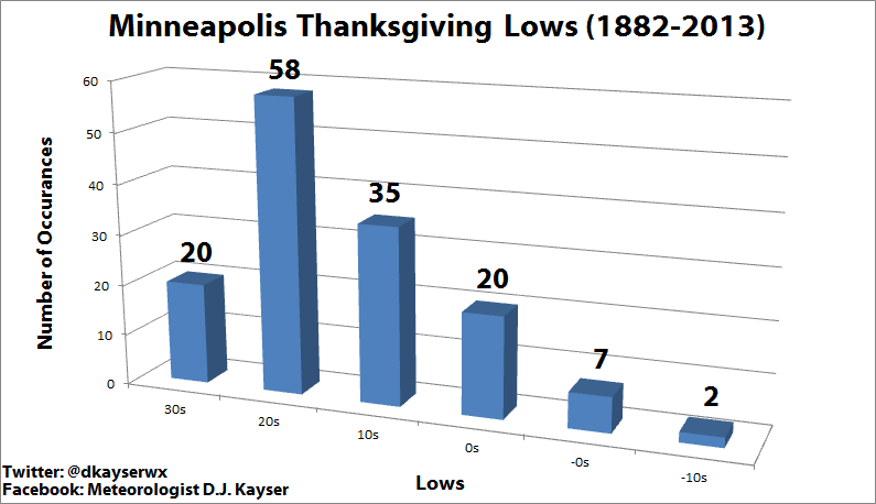 Thanksgiving Lows In The Twin Cities
.
There have been only 9 Thanksgivings with subzero wake-up temperatures
since 1882; statistically we're much more likely to wake up to 20s at
KMSP.
No, It Won't Be This Cold.
We'll wake up to single digits Thursday morning, colder than average,
but not the crazy-cold of 1880 (or 1985 for that matter).
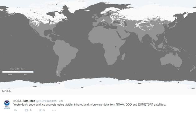
Global Snow Cover.
NOAA released a map showing regions of the world with snow on the
ground. Most of Europe is still snow-free, so is China and the Middle
East. Map courtesy of NOAA and
Twitter.
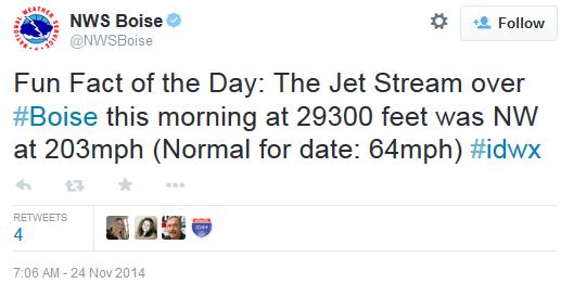
Bad Hair Day at 29,300 Feet.
NOAA radiosonde (weather balloon) data showed a sustained wind over 200
mph nearly 30,000 feet above the ground over Boise this morning.
Potential for El Nino Continues To Rise.
The Australian Bureau of Meteorology has gone from alert to watch,
placing the odds at an El Nino warm phase in the Pacific at 70% Who
cares? Well, if El Nino does kick in this winter there's a higher
probability of more of a zonal, west to east flow, alternating with the
Canadian smacks, meaning a somewhat lower risk of the jet stream getting
stuck in a polar holding pattern similar to last winter. Source: NOAA
CPC.
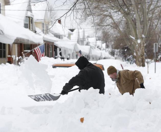
Winter Weather Weirdness May Be Just Beginning.
The Buffalo News, where they know a thing or two about odd weather, has the story - here's an excerpt: "...
Meteorologists
and geographers say that lake-effect snows have increased as
temperatures have warmed in recent decades. That means more bizarre
early-season storms, though not necessarily as bad as last week’s, are
likely in the future as the warming trend continues. “The general notion
is that, as the climate warms and the lakes hold their warmth longer
into the fall, you’re going to see a lot more lake-effect snow until
it’s too warm to have much snow,” said Mark Monmonier, distinguished
professor of geography at Syracuse University and the author of the 2012
book “Lake Effect: Tales of Large Lakes, Arctic Winds, and Recurrent
Snows...”
Photo credit above: "
Mark Petrik and
Dennis Smith dig out their south Buffalo driveway on Saturday, Nov. 22,
2014, in Buffalo, N.Y. Western New York continues to dig out from the
heavy snow dropped by this week by lake-effect snowstorms." (AP Photo/Mike Groll).
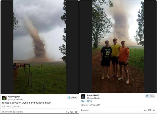
South African Tornado Caught on Video. Check out some amazing
KZN tornado footage from News24 in South Africa. Note: do not try this at home. Tweets courtesy of
East Coast Radio.
See What You'll Look Like In 20 Years.
Don't try this on an empty stomach (or after a couple of drinks). In
fact you may not want to try it at all, after the (lousy) results I got.
Fastcodesign.com has the story; here's an excerpt: "...
I was compelled to take part in this strange “Futureself” promotional campaign by UK telecom company Orange, created by publicis conseil and jam3.
So I looked into my webcam, hit a button, watched as all sorts of
calculating polygons run over my photo, and—like a very low budget Back
to the Future reboot, I came face-to-face with a moving, talking, 3-D representation of future me...."
* The web site capable of ruining an otherwise mediocre Tuesday is
here.
32 F. high in St. Cloud Monday.
34 F. average high on November 24.
34 F. high on November 24, 2013.
3" snow on the ground.
November 24, 1977:
Record lows were set across central Minnesota with lows in the teens to
single digits below zero. Montevideo had the coldest temperature of 18
degrees below zero along with Long Prairie at 16 degrees below zero.
November 24, 1820: Ft. Snelling is in the middle of a three-day blizzard that would dump nine inches of snow.
TODAY: Partly sunny, less wind. Winds: SW 5-10. High: 25
TUESDAY NIGHT: Clouds increase, light snow possible by morning. Low: 20
WEDNESDAY: Coating to 2 inches of light snow possible (best chance south/west of STC). High: 27
THANKSGIVING: Chilled sunshine. Turkey hangover. Wake-up: 1. High: 15
FRIDAY: Snowy coating early, not as harsh. Wake-up: 11. High: 28
SATURDAY: Mostly cloudy. Risk of a thaw. Wake-up: 23. High: 33
SUNDAY: Patchy clouds, turning breezy and cooler. Good travel. Wake-up: 16. High: 21
MONDAY: Plenty of sun. Allergy-free! Wake-up: 3. High: 18
Climate Stories...
How To Talk About Climate Change at Thanksgiving: Recipes For Good Conversations. Aaron Huertas has some good advice in The Equation, at
The Union of Concerned Scientists; here's an excerpt: "...
Instead
of having an argument, ask them where they read or heard a given point.
Tell them you heard something different somewhere else. Don’t be
defensive or aggressive about it. This isn’t about proving you’re right.
It’s about sharing perspectives. Keep asking questions. You’ll probably
find that someone’s skepticism toward climate science stems from a
negative attitude about climate policy and politics rather than
substantive objections to the science. Similarly, a lot of people who
accept the science are depressed about our prospects for dealing with
climate change..."
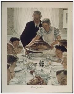
Image credit above: "
Some
people love it; others dread it, but make no mistake: Thanksgiving is as
American as apple pie and it’s one of the few chances we have to come
together as families." (Norman Rockwell’s Freedom from Want, via Wikipedia.)
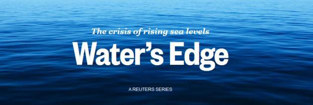
In Metro Houston, An Uphill Fight To Build a Texas-Size Defense Against The Next Big Storm. Here is the latest installment in an impressive series from
Reuters on how America is more vulnerable than ever to sea level rise; here's a clip: "...
As
previous articles in this series showed, the threat of rising seas is
not an alarmist prediction. It is already a reality, resulting in
increased tidal flooding and worsening storm damage along much of the
U.S. coast. And even as the water has risen, subsidies for flood
insurance, utilities and disaster bailouts are encouraging development
along some the nation’s most at-risk shores. For places like the Texas
Gulf coast, which on average gets slammed with a major hurricane every
15 years, higher waters mean a storm today will tend to be much more
dangerous than one of equivalent strength several decades ago..."
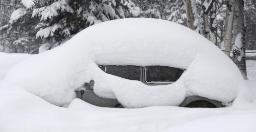
Expect More Giant Snowstorms As Climate Warms. A
warmer atmosphere contains more water vapor, loading the dice in favor
of not only heavier summer rains, but more extreme winter snows - until
temperatures become too warm for snow.
LiveScience has the story; here's an excerpt of the article, including a quote from Penn State climate scientist Michael Mann: "...
Part
of what gave us the record lake-effect snowfall in Buffalo was warm,
late-fall lake-surface temperatures that combined with something highly
unusual: a 5 sigma event. That is, a very unlikely event on the order of
1-in-a-million — a remarkably persistent, anomalous configuration of
the jet stream, which brought frigid Arctic air down into the United
States so early in the season," said Michael Mann, professor and
director of the Earth System Science Center at Pennsylvania State
University. "The cold winds traveling over the warm moisture-laden lake
created a perfect storm of conditions for record lake-effect snow..."
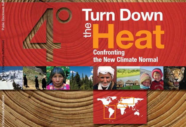
Global Warming: Extreme Weather Will Be The "New Climate Normal", World Bank Warns.
International Business Times has the article - here are a few clips that got my attention: "
The World Bank Sunday warned extreme weather will become the "new climate normal," increasing the risk of world instability. The report, "Turn Down the Heat: Confronting the New Climate Normal,"
analyzes the impact of warming of 2 to 4 degrees Celsius (3.6 and 7.2
degrees Fahrenheit) above pre-industrial levels on crops and
coastlines....Extreme heat is the biggest problem, the report found,
because it can reduce crop yields, negatively impacting food security
and future economic growth as well as economic development, social
stability and well-being..."
* the 320 page PDF "Turn Down The Heat: Confronting the New Climate Normal" from The World Bank is
here.

No comments:
Post a Comment