32 F. high in St. Cloud Saturday.
23 F. average high on December 20.
13 F. high on December 20, 2013.
1" snow on the ground.
December 20, 1993:
Strong northwest winds gusted to 35 miles an hour and caused near
whiteout conditions over a wide area of southwest Minnesota during the
late afternoon on the 21st into the early morning of the 22nd. Several
car accidents occurred. A 30 year old man was killed when he lost
control of his truck and slid into a ditch in the near blizzard like
conditions. Counties affected include: Blue Earth, Brown, Chippewa,
Faribault, Lac Qui Parle, Redwood, Renville, Watonwan, and Yellow
Medicine.
December 20, 1939: Latest date for Lake Minnewaska to freeze over at Glenwood.
Dark Daze
I'm
taking a break from the Bob Dylan-Spam-Tidy Bowl on ESPN 7 to ponder
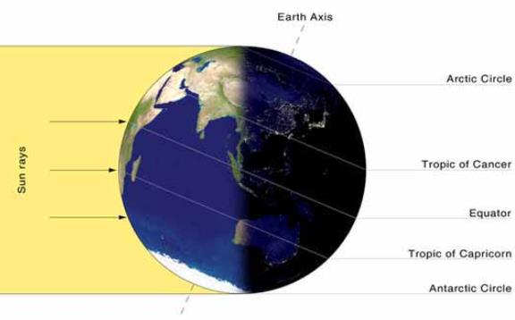
the Winter Solstice, the start of the sun's inevitable comeback. Today
brings the shortest daylight of the year: 8 hours and 46 minutes of
meager sunlight. That compares with 15 hours, 37 minutes of daylight on
June 21.
I have a hunch my distant ancestors hibernated from
November thru March. And pioneers hunkering down at Fort Snelling
endured a parade of blizzards, disease, filth and boredom, but somehow
they managed. No electronic distractions, just books, games, cards &
whiskey. Not necessarily in that order.
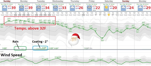
Last year 9 inches of
snow was on the ground on Christmas Day. This year we'll be lucky to
wind up with an inch of slush, after an extended thaw from today into
Wednesday morning. The atmosphere should be mild enough aloft for rain
tomorrow; a coating to an inch or two of slush Tuesday before flurries
taper Christmas Eve. The sun peeks out Christmas Day with highs in the
20s; Friday's snow chance has diminished. Sorry for the false alarm.
That's the thing about El Nino winters: they tend to be milder, cloudier and foggier, with fewer storms overall.
Not as much polar-vortex-babble in the media, either.
Thaw Into Christmas Eve - Snowy Coating for Santa?
No, we will not see any major snowfalls between now and Thursday. The
atmosphere will be warm enough aloft for very light rain and drizzle
today and Monday, changing to wet snow Monday night and Tuesday, when a
coating to an inch of slush could accumulate, maybe a couple inches
north metro. But that's pretty much it before we dry out Christmas Eve
with a few glimmers of sun Christmas Day. It cools off late in the week
but the really cold weather doesn't arrive until the last few days of
the month.
Roller Coaster Temperatures in December. Here's an excerpt of this week's
WeatherTalk Newsletter with Dr. Mark Seeley: "...
After
starting the month with many sub-zero F temperature readings around the
state during the first week, including a national low of -12 F at
Embarrass on the 6th, many Minnesota observers reported 11-12
consecutive days with above normal temperatures and several new daily
record warm minimum values and record daily warm maximum values were set
over the 13th to the 15th. In addition MSP set a new all-time record
high dewpoint for so late in the month with a reading of 49 F on the
15th, that corresponds to the average dewpoint for early June or
mid-September..."
Nature's Own Tornado Detector Saves Migrating Birds, Study Finds.
Is it possible (some) birds can detect the faint vibrations of a
distant tornado, one that's hundreds of miles away? I wouldn't rule
anything out after reading this story at
tucson.com: "...
The
data showed that five of his recently returned golden-winged warblers
fled their Appalachian Mountain breeding ground and winged back to the
Gulf of Mexico a day or two ahead of a massive thunderstorm cell that
would later spawn 84 tornadoes and kill at least 35 people. Streby, a
National Science Foundation visiting research scholar at the University
of California, Berkeley, thinks the birds may have been reacting to very
low-frequency sound waves produced by the distant, approaching storm,
according to a study published online Thursday in the journal Current
Biology..."
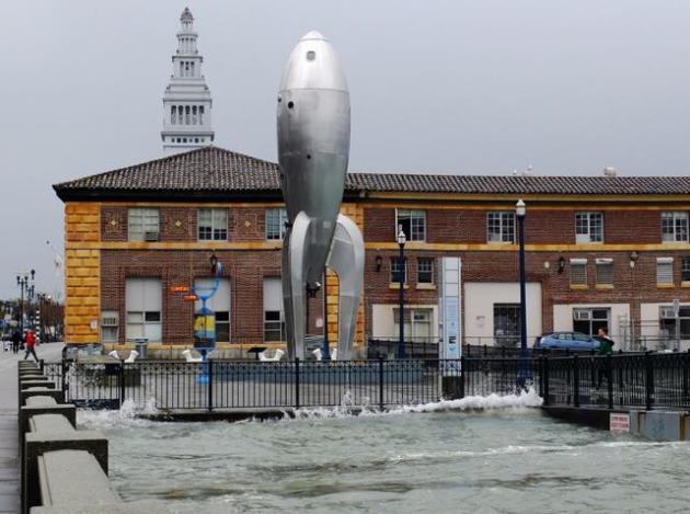
Tipping Point Nears For "Emerging Flooding Crisis".
Sea levels are rising, that's not a computer model, that's reality,
with is increasing the frequency of tide and storm-related coastal
flooding, as reported at
Climate Central - here's an excerpt: "...
Flooding
has already become 10 times more likely in Baltimore and Honolulu and
five times more likely in Philadelphia, Norfolk, Va., and Charleston,
S.C., since 1930. That’s in large part because since the start of the
20th century, sea levels have risen by about 8 inches globally due to
human greenhouse gas emissions that have caused oceans to warm and land
ice to melt, swelling the seas. “It’s an emerging flooding crisis,” William Sweet, an oceanographer with NOAA who led the new report, said..."
Photo credit above: "
Flooding on San Francisco's Embarcadero during the 2012 King Tide." Credit: Sergio Ruiz/Flickr.
Heart-Pounding Video Documents American Airlines Flight Turbulence.
The home video is troubling, a vivid reminder of why you always want to
have your seat belt fastened when you're in a metallic tube traveling
at 500+ mph. Here's a clip from
The Washington Post: "
Video
of the American Airlines flight that was rocked by severe turbulence on
Tuesday will make your heart skip a beat, and might even convince you
to keep your seat belt fastened snug on your next plane trip. American
Airlines flight 280, which was on its way from South Korea to Dallas,
Texas, was diverted to Tokyo on Tuesday after plane-jarring turbulence
injured several people, some of whom were later hospitalized
for injuries that were not life-threatening.."
The Sony Hackers Are Terrorists.
Sony's corporate security was thought to be average, and if it can
happen to them, it can happen to pretty much any company out there
today. Here's an excerpt from a story at
Slate: "...
This
is the real story. Sony Pictures’ systems were not just compromised but
obliterated, with the company now sent back to what’s comparably the
technological Stone Age. Because of the centrality of IT infrastructure
to every aspect of a company’s functions, it’s not even clear whether
Sony has the ability to pay people accurately at the moment, as its
payroll system has been reportedly destroyed..."
Photo credit above: AP Photo/Eugene Hoshiko, File.
The Lesson of the Sony Hack: We Should All Jump to the "Erasable Internet". Are we moving toward the Snapchat Internet? At this point nothing would surprise me; here's an excerpt from
The New York Times: "...
Because
here’s the thing about the digital world that we must remember. Nothing
you say in any form mediated through digital technology — absolutely
nothing at all — is guaranteed to stay private. Before you type
anything, just think: How will this look when it gets out? What will
Angelina Jolie think if she finds out about this? If Angelina won’t like
it, don’t send it. Because Angelina will find out. So will the rest of
the world..."
The 33 Craziest Fast Foods of 2014. As
Buzzfeed rightfully points out, "pray for humanity".
TODAY: Fog and drizzle. Very gray. Winds: South 10. High: 36
SUNDAY NIGHT: Foggy and damp, light mix or drizzle. Low: 33
MONDAY: Periods of rain. Wet roads. High: 38
TUESDAY: A chance of wet snow, coating of slush? Wake-up: 32. High: 34
CHRISTMAS EVE: Flurries taper. Santa sightings late. Wake-up: 30. High: 32
CHRISTMAS DAY: Some Assembly Required. Some sunshine too. Wake-up: 22. High: 29
FRIDAY: Chance of snow far south. Wake-up: 19. High: 26
SATURDAY: Mostly cloudy, chilly. Good travel. Wake-up: 8. High: 22
Climate Stories....
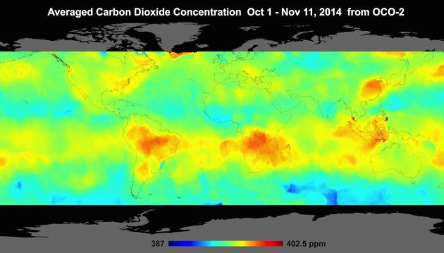
NASA Reveals What Carbon Dioxide Looks Like From Space. Meteorologist Andrew Freedman has the article for
Mashable; here's the intro: "
NASA
revealed the first-ever images of the global atmospheric concentration
of carbon dioxide, the key long-lived global warming gas. The imagery,
taken over the course of three months, reveals details about springtime
biomass being burned in the Southern Hemisphere, as well as
photosynthesis from plants worldwide. The data comes from a new NASA
satellite known as the Orbiting Carbon Observatory-2 (OCO-2) that was
launched on July 2 of this year..."
Image credit above: "
Global
atmospheric carbon dioxide concentrations from Oct. 1 through Nov. 11,
as recorded by NASA's Orbiting Carbon Observatory-2. Brighter colors
show high CO2 concentrations." Image: NASA JPL.
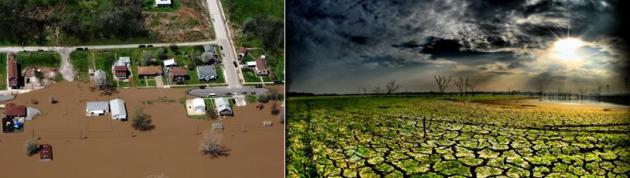
Op-Ed: Flood, Drought Risks Must Be Managed, With Or Without Climate Change. Here's an excerpt of an Op-Ed at
The Los Angeles Times: "...
Climate
change is increasing the risks of future droughts and floods. The sea
will continue to rise, increasing flood risk along the East Coast,
perhaps made worse by intensifying hurricanes. And the best science
indicates that California's wet season will become shorter and sharper.
Spring drying will be exacerbated as more water is lost to evaporation
into a warmer atmosphere and less is stored as winter snow..."
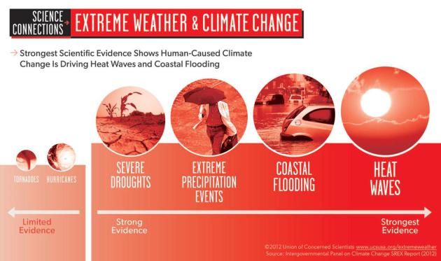
EPA Chief: Extreme Weather Boosting Climate Change Plan.
Some Americans may still be skeptical of a man-made component to
climate change, but there's little doubt that the frequency and
intensity of the extremes is increasing over time. Here's an excerpt
from
USA TODAY: "
Extreme
weather events from typhoons to heat waves are helping make the case to
Americans on the need to address climate change, the head of the EPA
says, although opposition from congressional Republicans to the Obama
administration's ambitious plan remains unrelenting. "You have fires;
you have droughts," Environmental Protection Agency Administrator Gina
McCarthy said in an interview with Capital Download. "People may not
call it climate change," but they feel the consequences from changing
weather patterns, including on the economy. "This is about their own
jobs, their own health, their own kids..."
Graphic above: Union of Concerned Scientists.


No comments:
Post a Comment