43 F. high in St. Cloud Saturday.
45 F. average high on March 28.
32 F. high on March 28, 2014.
March 29, 1986: Record warmth with July-like temperatures. The Twin Cities hits 83.
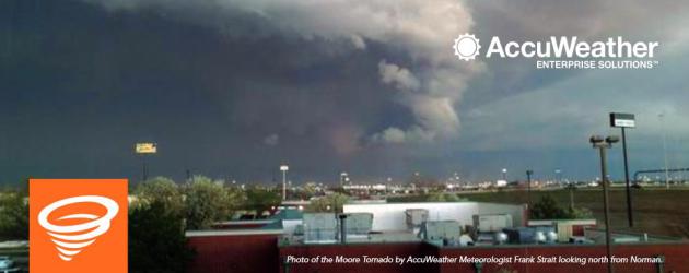
Tornado Magnet
We
live with risk; a dark potpourri of natural disaster threats that vary
across the USA. Overall weather and climate risk is greatest in the
southern USA, which hosts both tornado alley as well as hurricane alley.
The safest major U.S. cities: San Diego, Albuquerque and Honolulu, but
even here the risk from tremor, storm and wildfire isn't zero.
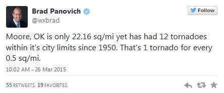
People
living in Moore, Oklahoma have to be wondering what's going on. Last
Wednesday's EF-1 tornado strike was tame compared to the three monstrous
(EF-5) tornadoes that have struck the suburb of Oklahoma City since
1998. The town is only 22 square miles in size, but according to
meteorologist Brad Panovich it's been struck by 12 tornadoes since 1950.
An accident of geography? I wonder if the heat island of OKC might play
a role spinning up more (major) tornadoes over Moore. Very odd.
A
week ago today the southwest suburbs were treated to 9 inches of snow.
Today the sky above our heads is warm enough for rain showers. 50s
return by tomorrow; 60s midweek with a stray thunderclap before we cool
off next weekend.
4 of the last 5 springs have been historically wet in Minnesota. Will history repeat itself again in 2015?
I doubt it.
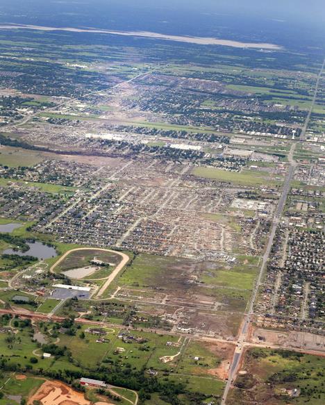
File photo credit above: "
This
May 21, 2013 file aerial photo shows the remains of houses in Moore,
Okla., following a May 20, 2013 tornado. There have been fewer tornadoes
nationwide through the month of March than in the past 10 years. In
Oklahoma, two years after deadly tornadoes ripped into the state's
midsection, there could be a second straight year of an uneventful
tornado season. It's part of what forecasters are calling a 'tornado
drought.' (AP Photo/Kim Johnson Flodin, File).
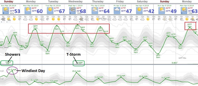
Windblown Sunday.
A fast-moving clipper sparks 35 mph wind gusts in the Twin Cities, but
over central and western Minnesota winds may gust as high as 40-50 mph.
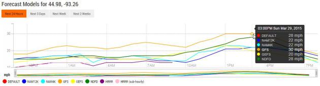
Sustained Winds Peak This Afternoon.
Our suite of models show sustained winds reaching 22-30 mph by early
and mid afternoon today, gusts as high as 40 mph in the Twin Cities.
Source: Ham Weather.
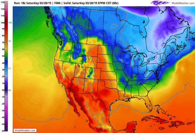
Flirting With Spring Again Next Week.
Temperatures top 50F today with windblown showers, but it starts to
feel like spring again Monday into Thursday with a streak of 60s before
temperatures cool down by the weekend. A few claps of thunder are
possible Wednesday along the leading edge of cooler air.
Spring Fever Returns Next Week.
GFS guidance suggests low 70s Wednesday; 60-degree plus weather likely
Monday into Thursday of next week. Numbing cold and snow showers over
the Northeast give way to moderating temperatures in the coming days;
record to near-record warmth continues across the southwestern USA. GFS
guidance: NOAA and HAM WEATHER.
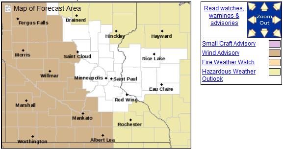
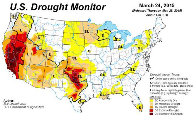
Expanding Drought.
99% of Minnesota is abnormally dry, over 88% of the state in moderate
drought. Unusually dry conditions stretch from the Dakotas to Wisconsin,
with severe (perpetual) drought deepening across California, where it
promises to be a long, dry, abnormally warm year. Pockets of extreme to
exceptional drought are showing up from Oklahoma City to Wichita Falls,
Texas.
Warmer Bias Returns in March. Dr. Mark Seeley provides perspective on a statewide basis; here's an excerpt of
WeatherTalk: "...
It
appears that March will wrap up bringing higher temperatures and more
moisture the last few days of the month. Most observers will report a
mean monthly temperature from 4 to 7 degrees F warmer than normal (mean
values), and total precipitation that is less than normal. Extremes for
the month were 78F at Browns Valley on the 15th and -40F at Cotton on
the 5th, with the highest monthly precipitation value of close to 2
inches at Lanesboro..."
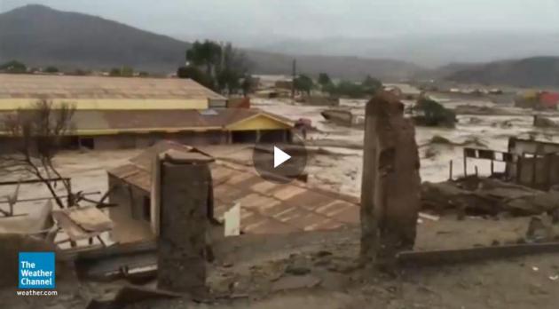
7 Years of Rain in Chile Desert Kills At Least 9. Here's more information and a video, courtesy of
weather.com: "
Thunderstorms
brought the equivalent of 7 years of rain to Chile's Atacama desert
region and caused deadly flooding Thursday. Antofagasta, Chile, where
the annual average precipitation is 0.13 inches, saw 0.9 inches of rain in 12 hours.
"The Atacama Desert is an extremely arid region and has been for
millions of years. As a result, the terrain is hard and rocky because
rainfall isn't frequent or abundant enough for either weathering rocks
into sand or supporting the kind of ecosystem that would help turn rocks
and minerals into soil. Without soil and plant cover to help absorb
rainfall, it just runs off instantly as torrents of water," weather.com
senior meteorologist Nick Wiltgen said..."
Moore, Oklahoma: Tornado Magnet. The Washington Post's
Capital Weather Gang
has a good summary of Wednesday's tornado outbreak, and speculates on
why the southern suburbs of Oklahoma City have been struck so often in
recent years: "...
Other than the fact it lies in the heart of tornado alley, there is no clear reason why Moore keeps getting hit by tornadoes. Studies have shown
urban environments can sometimes enhance rain from thunderstorms
downwind of cities (and Moore is just south of Oklahoma City), but
little work has been done to determine if cities impact tornado
formation..."
AccuWeather Rips National Weather Service For "Late Tornado Warning".
I had no idea AccuWeather was issuing their own warnings. You can read
their write-up about the recent Moore EF-1 tornado and how they
approached the storm
here.
Advanced Warnings Questioned After Tornado. More complaints from Moore residents highlighted in the
Norman Transcript.
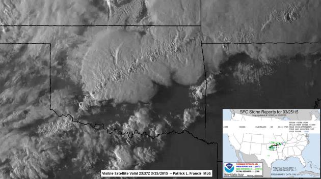
Overshooting Tops.
This high-resolution visible image from NOAA was taken as an EF-1
tornado formed over Moore, Oklahoma. If you look carefully you can see a
line of knobs on top of the overshooting thunderstorm anvil tops,
marking zones of extreme upward motion, where upward motion extended
into the stratosphere. Image: Ham Weather.
Let's Give Them Something To Tweet About - - Why Periscope Matters. Dave Pell at NextDraft takes a look at how the addition of live video streaming with Periscope in Twitter may turbocharge self-publishing. All those cat videos. Here's an excerpt: "...That’s
where Periscope comes in. Except in rare cases, these streamed events
will not be global or even national in nature. But they will be live,
we’ll know exactly who’s watching with us, and the content will be
pushed through the same pipes that support our conversations around it.
Live fodder for discussion and the discussion itself all on the same
social network. To paraphrase the great Bonnie Raitt, Twitter had to
give us something to Tweet about..."
 TODAY
TODAY: Windy with AM rain showers. Winds: W 20-35. High: 52
SUNDAY NIGHT: Partial clearing. Low: 33
MONDAY: Clouds linger, late day shower? High: 57
TUESDAY: Partly sunny and pleasant. Wake-up: 41. High: 61
WEDNESDAY: Feels like spring, thunder late. Wake-up: 47. High: 64
THURSDAY: Intervals of sun, turning cooler. Wake-up: 45. High: 56
FRIDAY: Storm stays south. Some sun. Wake-up: 35. High: 51
SATURDAY: What April? Jackets return. Wake-up: 29. High: near 40
Climate Stories...
Media Contributing to "Hope Gap" on Climate Change. Another
reason why denial is in vogue with some people - a sense of malaise and
hopelessness. There are solutions and we will figure out cleaner ways
to keep the lights on and add new jobs. Here's an excerpt from
Climate Central "...
Perhaps more provocatively, the results of the detailed analysis also suggest that newsrooms on both sides of the warming pond
are struggling to produce stories about climate change in ways that are
engaging for their audiences. Instead, they’re fueling senses of
hopelessness on the issue. “I don’t find their major findings
surprising,” Anthony Leiserowitz,
director of the Yale Project on Climate Change Communication, said of
the study, with which he was not involved. “We find in our audience
research that even the alarmed
[those most concerned about climate change] don’t really know what they
can do individually, or what we can do collectively. We call this
loosely ‘the hope gap,’ and it’s a serious problem..." (Photo: Lori Ryan).
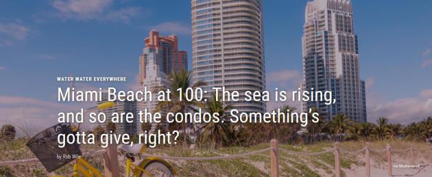
Miami Beach at 100: The Sea Is Rising, So Are The Condos. Fusion has an interesting story - here's an excerpt: "
This
past fall, the City of Miami Beach—one of America’s most famous beach
resorts since it was founded 100 years ago this month—faced the King
Tide. King Tide is an unscientific term for a particularly strong high
tide. For Miami Beach residents, that typically means flooding, and lots
of it. The city’s main arteries typically shut down for days at a time
as 88,000 residents wait for the water to drain..."
Will Climate Change Drown The Party on Miami Beach? Rent, don't buy. Here's a link to a good video explainer from
Fusion: "
Miami
Beach has been dubbed ground zero for the consequences of climate
change, where rising sea levels are a constant threat to the city.
Fusion’s Nicolas Ibarguen took a look into the stark future Miami faces
as climate change takes root."
Keeping Global Warming at 2C Rise May Not Be Enough, Says Climate Expert. Tech Times has the story; here's a clip: "...
Experts
claim that the 2°C limit may still lead to shifts in rainfall patterns,
the increase in sea levels and extreme natural events, such as heat
waves, floods and droughts, especially in the tropics, high mountain
areas and even the polar regions. Petra Tschakert, lead author of the
IPCC Fifth Assessment Report, believes that the 2°C target may pose a
threat to livelihoods and ecosystems..."
Photo credit above: "
Maintaining
a target of a 2°C temperature rise for the entire planet may still lead
to the devastating effects of global warming, a leading climate
scientist warns." Photo: USGS.


No comments:
Post a Comment