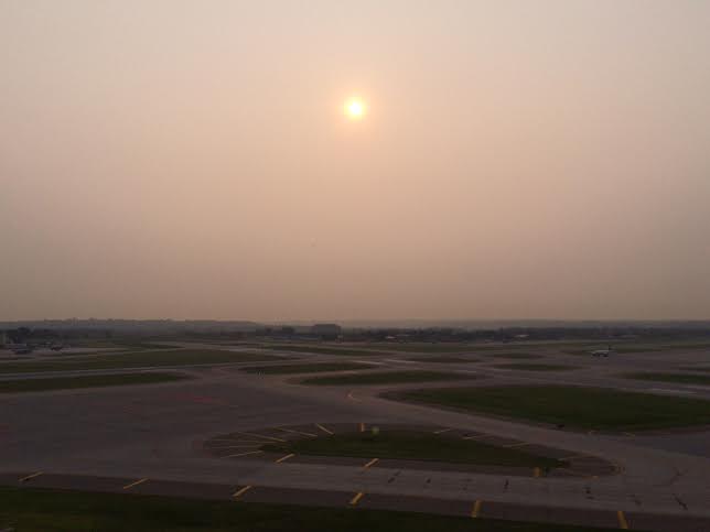
Did you notice anything different about the sunrises and sunsets this weekend? Didn't the sun look more red/orange than normal? You can thank smoke from distant wildfires in Canada, Northwest Territories and Alaska! A thick plume drifted over the region Friday and Saturday and made for some pretty interesting looking skies. However, not sure if it was just me, but I sure felt like my throat was a little scratchy with all this hazy stuff floating around... Interestingly, the National Weather Service was getting reports of ash falling in the St. Cloud area on Friday!!
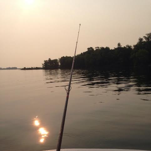
Note that even the sun's reflection in the water looks smoky! Neat picture Jackie!!
(Image below courtesy: Jackie Koch)
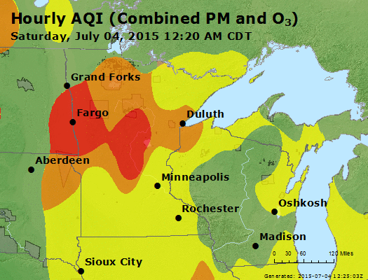
Poor Air Quality
This was the air quality loop from early Saturday morning, which showed particularly high levels of particulates over parts of central and northern Minnesota. Much of this can be attributed to the smoke across the area thanks to all the wildfires across Canada, Northwest Territories and Alaska. COUGH - HACK - UGH!
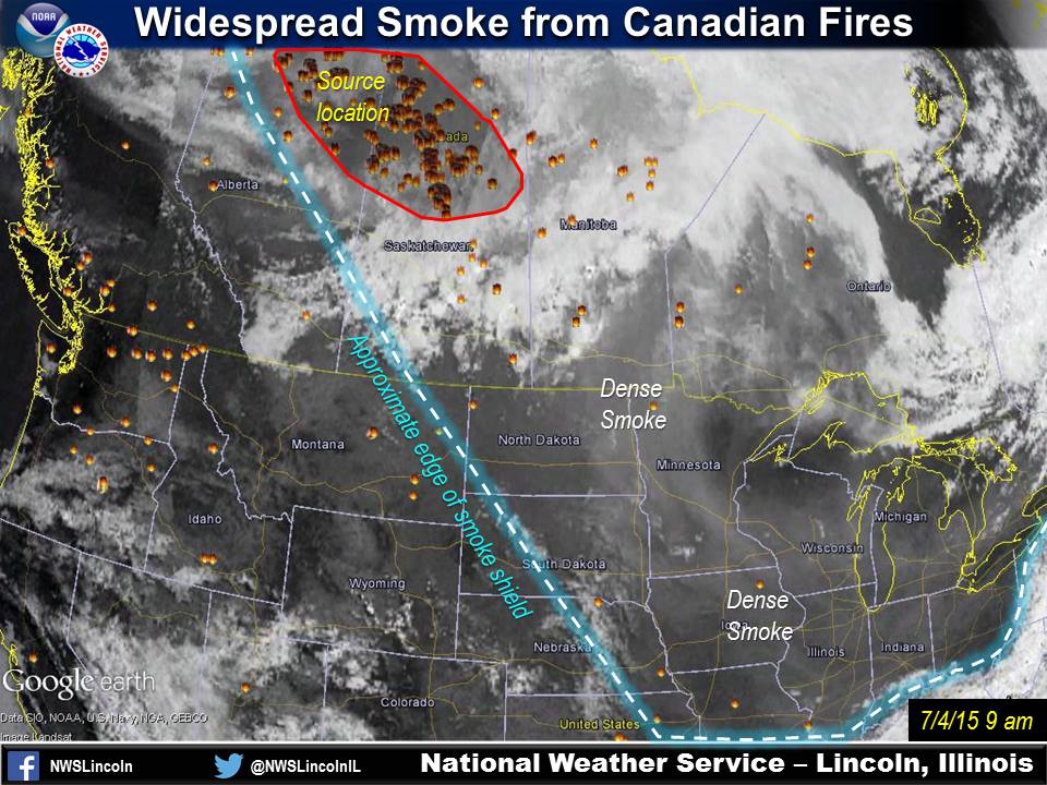
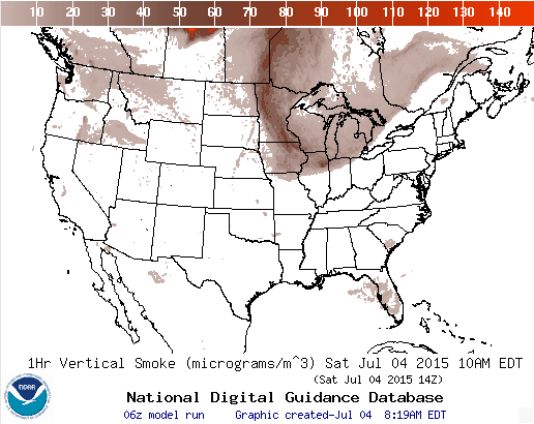
Smoke Via Visible Satellite
Thanks to the National Weather Service out of Central Illinois for the image below showing how widespread the smoke was on Saturday, the 4th of July:
The visible satellite image from Saturday morning showed much of the Midwest was still being affected (milky gray shades, contrasted by the bright-white appearance of the clouds). If the smoke gets thick enough, it can actually reduce high temperatures by a couple degrees, similar to thick high clouds. Sunrise and sunset will continue to appear redder than usual, and if the smoke starts to work its way more toward the surface, it can cause irritation for people with breathing difficulties.
See more HERE:
Smoke Analysis 7AM Saturday
Take a look at how thick the smoke was across the Upper Mississippi Valley on Saturday morning. No wonder why it was so hazy and air quality was so bad... YUCK!
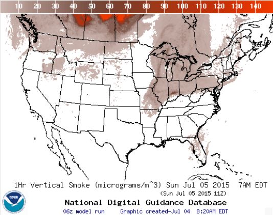
Smoke Analysis 7AM Sunday
The good news is that skies should appear more clear on Sunday across much of Minnesota as the smoke looks to drift a little farther east across the Great Lakes.
Stormy Sunday Night
By Todd Nelson
COUGH! HACK! UGH. Not sure about you, but I had a nagging cough and sore throat from all the ambient smoke and haze that was hanging around Saturday. Thanks to several large wildfires in Canada, Northwest Territories and Alaska, air quality close to home was running a bit on the unhealthy side. Interestingly, the National Weather Service was actually getting reports of ash falling around the St. Cloud area on Friday!
The good news is that skies should appear a little more clear Sunday as upper level winds have become more westerly. Winds at the surface will favor a more southerly direction, which will keep the warm and muggy air streaming northward ahead of a storm system that will plow through Sunday night with scattered storms and heavy rain. I wouldn't cancel any outdoor plans as much of the day looks dry, but a few strong storms and heavy rains look to conclude our holiday weekend overnight. The morning rush Monday looks wet as scattered storms rumble toward Wisconsin. 1 to 2 inches may be possible in central MN by PM Monday.
Heads up; temps near 90 degrees by mid July could prompt many to mutter a familiar summer phrase, "It's too hot."
__________________________
SATURDAY NIGHT: Warm and sticky - still dry. Low: 67. Winds: SSW 5-10
SUNDAY: Breezy. Sticky sun, T-storms at night. High: 87. Winds: S 10-20.
SUNDAY NIGHT: Storms develop (a few strong) with heavy rainfall. Low: 69. Winds: S 10-15
MONDAY: AM T-showers, slow PM clearing. High: 78. Winds: Turning NW 10-15
TUESDAY: Sunny, just about perfect with lower humidity. Wake-up: 59. High: 77
WEDNESDAY: Comfortable. More PM clouds. Wake-up: 60. High: 78
THURSDAY: Warmer. Stray PM T-shower? Wake-up: 68. High: 80.
FRIDAY: Sticky. Scattered PM rumbles. Wake up: 64. High: 84.
SATURDAY: Feels like summer. Unsettled PM. Wake-up: 65. High: 86.
__________________________
This Day in Weather History
July 5th
1999: Flooding over the Arrowhead. The largest 24-hour rainfall total was 8.84 inches in central St. Louis County.
___________________________
Average High/Low for Minneapolis
July 5th
Average High: 83F (Record: 100F set in 1982)
Average Low: 64F (Record: 45F set in 1972)
____________________________
Sunrise/Sunset Times for Minneapolis
July 5th
Sunrise: 5:33am
Sunset: 9:02pm
______________________________
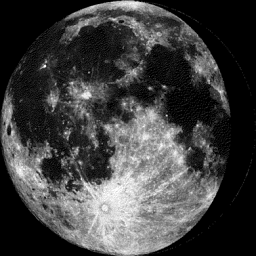
Moon Phase for July 5th at Midnight
2.6 Days Before Last Quarter
______________________________
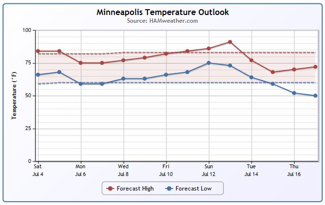
Minneapolis Temperature Trend
Mild and near average temperatures continue over the next several days with highs in the mid to upper 70s and low to mid 80s. Extended model runs are suggesting a bit of a warm up by mid July with highs approaching 90F.
___________________________________
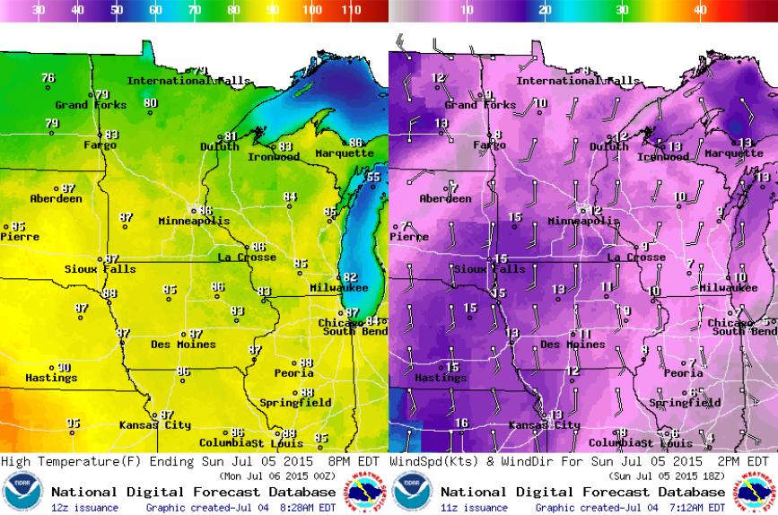
Sunday Weather Outlook
Much of the day Sunday will be nice and dry with sunshine and mild temperatures. It certainly won't be as hazy as it was on Saturday, but it will be a little breezy and more sticky as the dewpoint climbs a bit.
Sunday Weather Outlook
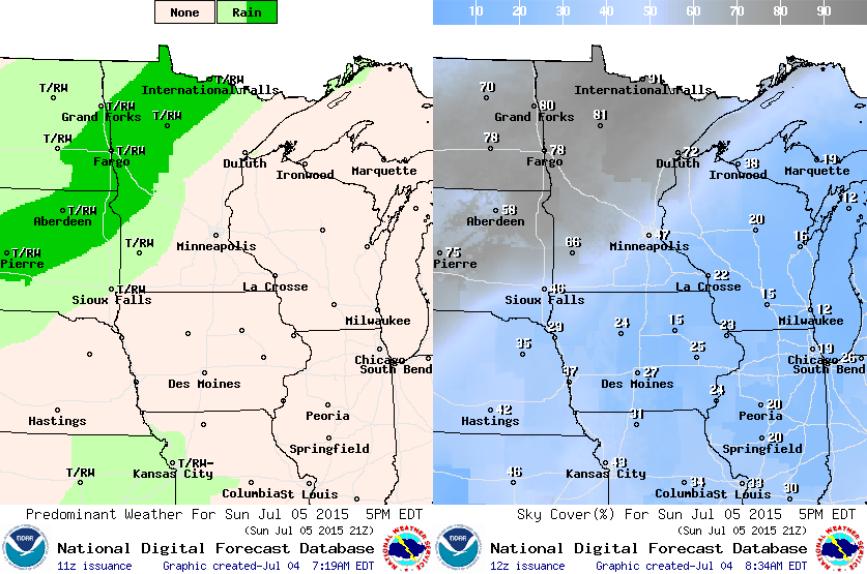
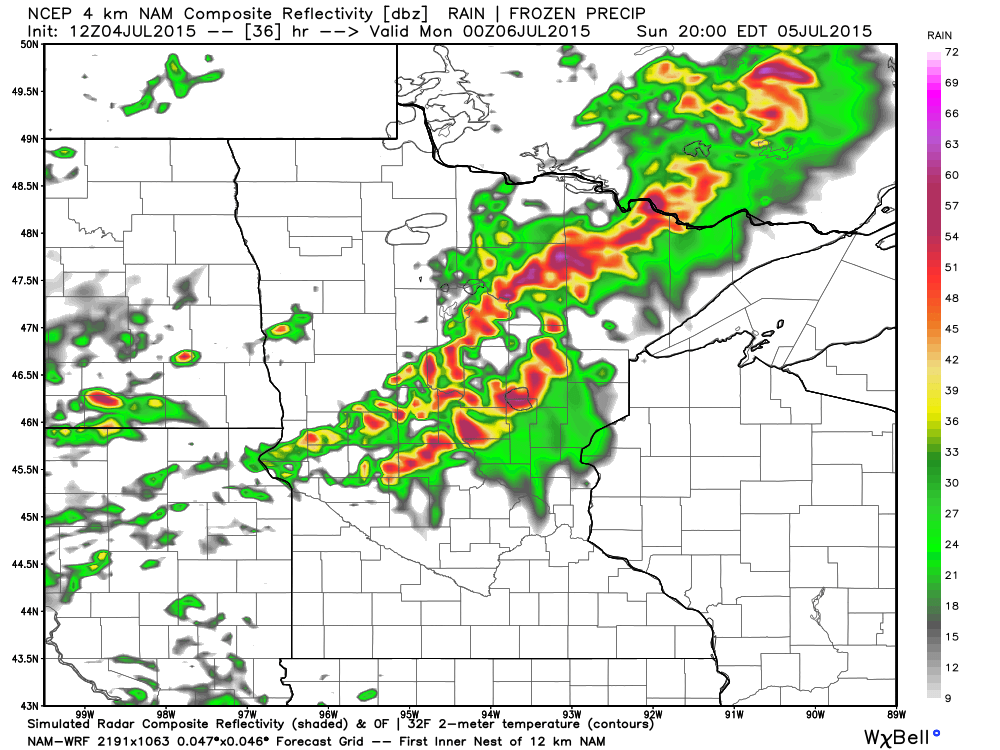
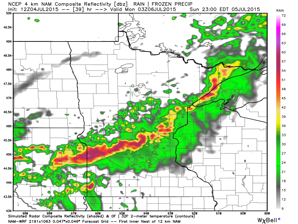
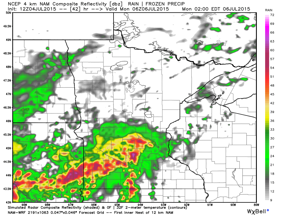
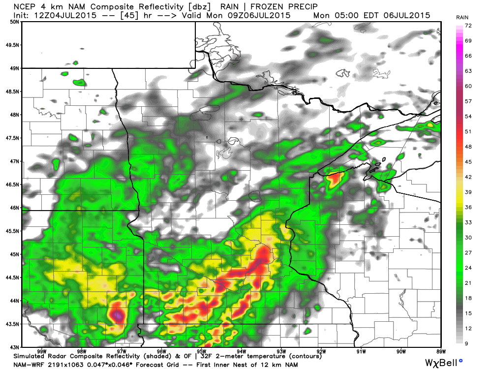
Much of the day Sunday will be dry, but a front moving in from the northwest will be responsible for scattered showers and storms late in the day/overnight. The images below suggest weather conditions by 5pm Sunday with showers and storms across northwestern Minnesota and the eastern Dakotas. Some of these storms could be strong to possibly severe with heavy rainfall...
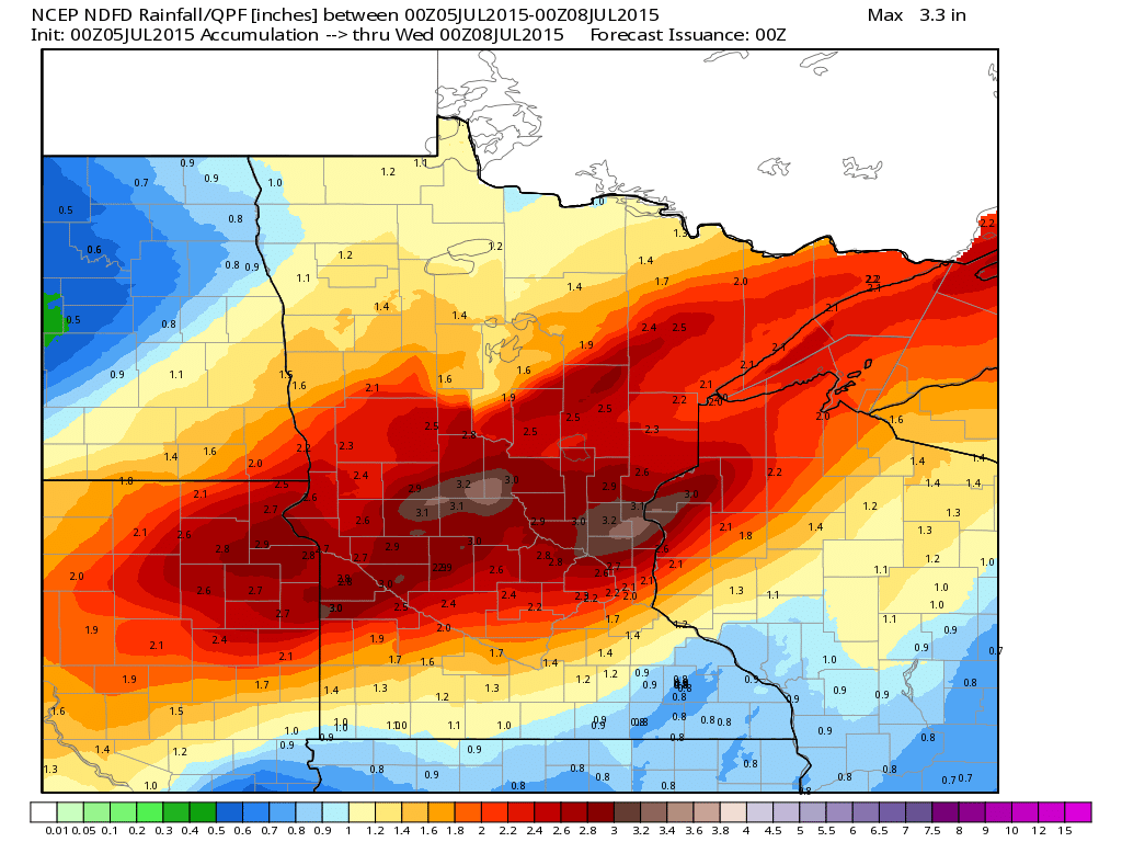
Rain Potential
Scattered thunderstorms look to develop late Sunday across the Dakotas and northern Minnesota. The trend will be to push east through Minnesota and Wisconsin Sunday night and Monday with potentially some strong storms, but also heavy rain. The forecast calls for as much as 1" to nearly 3" in spots through early week.
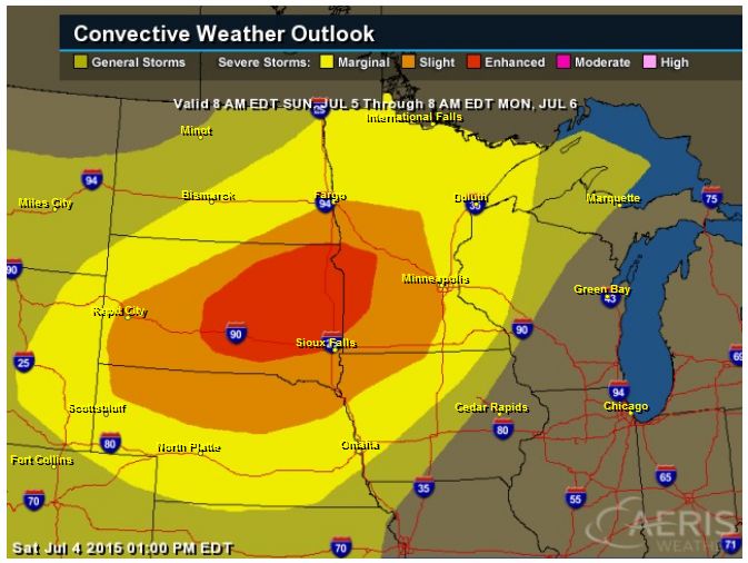
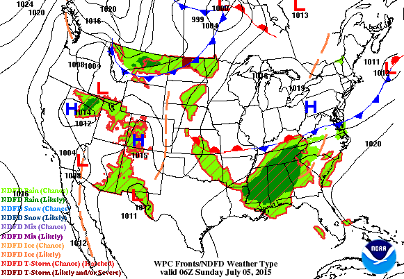
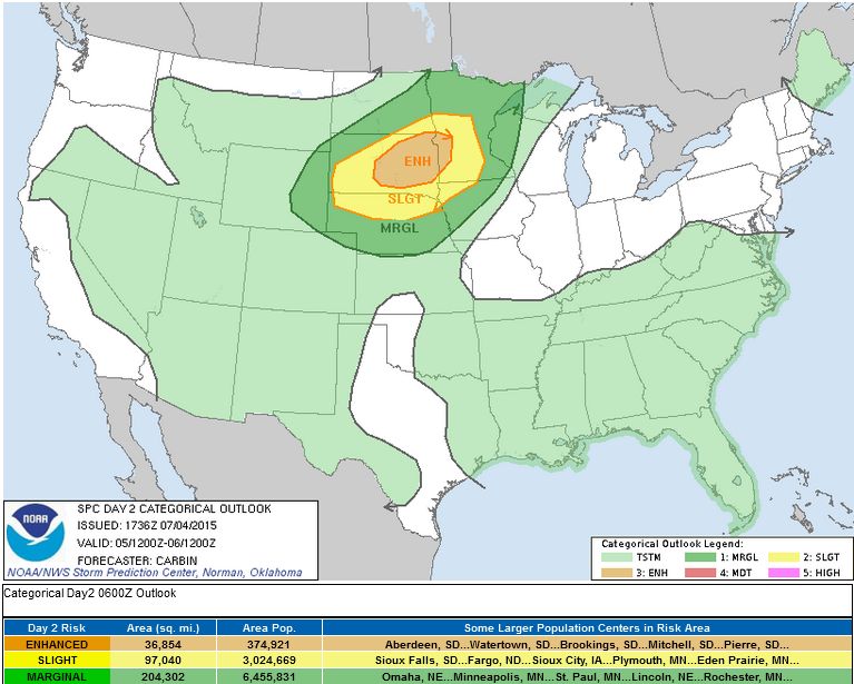
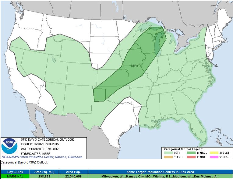
Sunday Severe Threat
A fairly vigorous storm system will push through the Midwest late Sunday afternoon/overnight with strong to possible severe storms across the region. The Storm Prediction Center has highlighted areas that have the best chance of severe storms through early Monday morning.
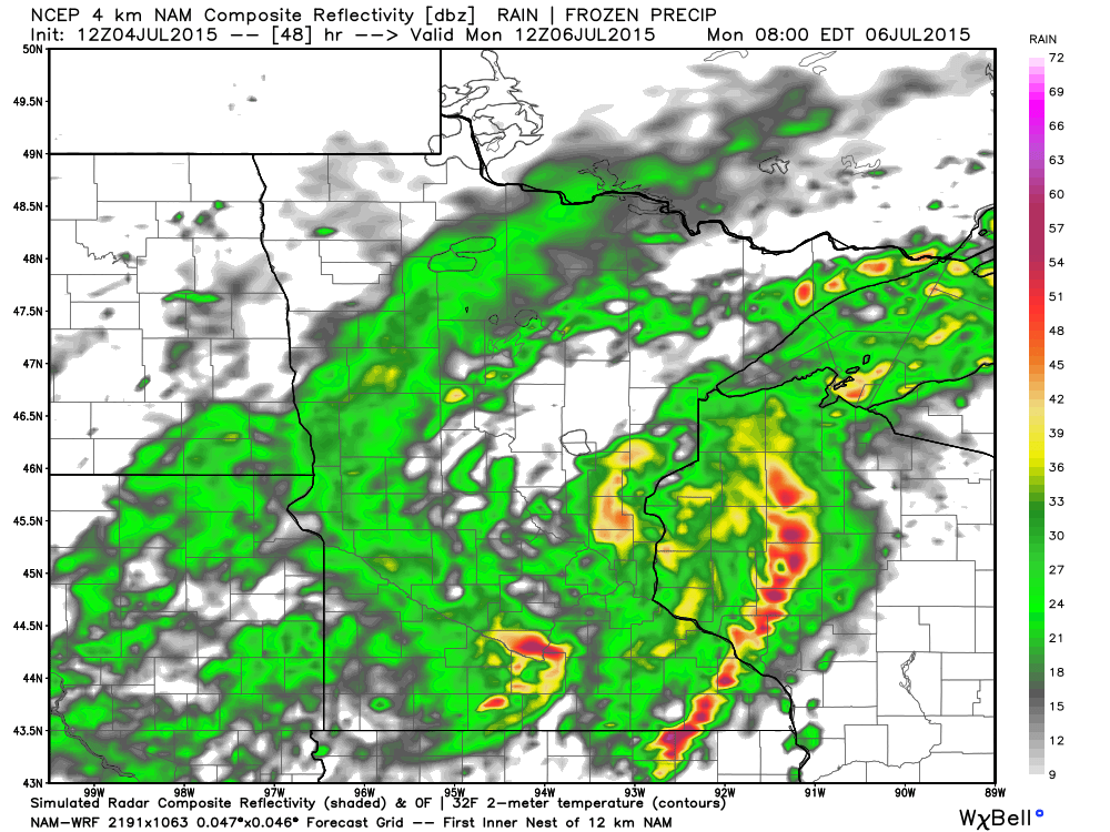
Simulated Radar 7pm Sunday
Simulated Radar 10pm Sunday
Simulated Radar 1am Monday
Simulated Radar 4am Monday
Simulated Radar 7am Monday
_____________________________________
National Weather Outlook
Scattered storms and heavy rainfall potential will round out the weekend across the southeastern part of the U.S., while another storm system develops across the Midwest. Note the storm system plowing south through the Midwest/Plains through into early next week. This will be responsible for scattered storms (some strong to severe) and heavy rainfall.
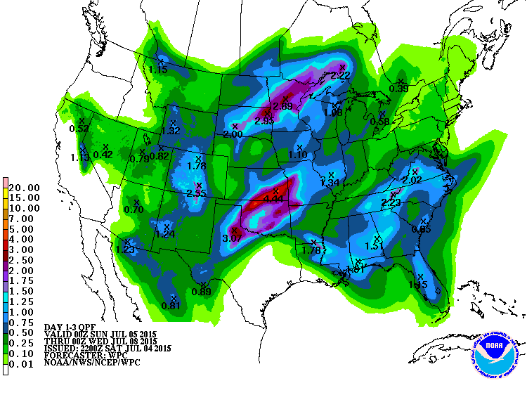
3 Day Precipitation Outlook
According to NOAA's WPC, the 3 day precipitation outlook shows pockets of heavy rainfall potential across parts of the Upper Midwest, the Central/Southern Plains and from the Lower Mississippi Valley to the Mid-Atlantic States. The heaviest amounts may be 1" to 3" or more possible through Tuesday.
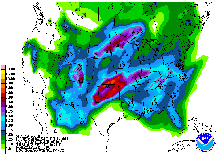
5 Day Precipitation Outlook
If we extend the precipitation outlook another 2 days, rainfall tallies look even more impressive over the Central/Southern Plains with as much as 2" to nearly 5" through Thursday. This may even lead to localized flooding concerns.
________________________________________
Severe Threat Saturday
...SUMMARY...
THUNDERSTORMS CAPABLE OF PRODUCING DAMAGING WINDS AND LARGE HAIL ARE
EXPECTED SUNDAY ACROSS PARTS OF NORTHERN PLAINS FROM NORTHERN
NEBRASKA ACROSS SOUTH DAKOTA AND INTO PORTIONS OF EASTERN NORTH
DAKOTA AND MUCH OF SOUTHERN MINNESOTA.
...OVERVIEW...
NORTHERN FLANK OF MID/UPPER RIDGE EXTENDING FROM FOUR CORNERS TO
CENTRAL PLAINS WILL BE DAMPENED CONSIDERABLY THIS PERIOD DUE IN PART
TO A PROGRESSIVE SHORTWAVE TROUGH DIGGING EAST-SOUTHEAST FROM THE
CANADIAN ROCKIES TO THE PRAIRIES. A FURTHER DAMPENING INFLUENCE IS
FORECAST TO OCCUR AS A COHERENT IMPULSE TRANSLATES EAST AROUND THE
NORTHERN PERIPHERY OF THE RIDGE...FROM THE NORTHERN GREAT BASIN TO
NORTHERN HIGH PLAINS...THROUGH SUNDAY NIGHT. RESULTANT PHASING OF
THE MIDLEVEL HEIGHT FIELD...FROM THE NORTHERN PLAINS TO UPPER MS
VALLEY...WILL CONTRIBUTE TO A BELT OF FASTER WESTERLY FLOW ALOFT AND
MODEST HEIGHT FALLS THROUGH LATE SUNDAY.
THERE IS BETTER AGREEMENT AMONGST LATEST GLOBAL MODELS AND ENSEMBLE
SYSTEMS THAT SUBSTANTIAL CONVECTIVE DEVELOPMENT WILL OCCUR ACROSS
EASTERN SD INTO MN LATE SUNDAY AS A SLOW-MOVING COLD FRONT AND LEE
CYCLONE/FRONTAL WAVE DEVELOP INTO THESE AREA AMIDST STRONG
DESTABILIZATION.
A BROAD AND LUMBERING MID/UPPER TROUGH...ACCOMPANIED BY 20-30 KT
500MB FLOW ON ITS EASTERN FLANK...WILL SPREAD VERY WEAK HEIGHT FALLS
EAST-NORTHEAST FROM THE DEEP SOUTH TO SOUTHEAST. FORWARD PROGRESS OF
THIS DISTURBANCE WILL BE SLOWED BY AN EVOLVING BLOCK IN THE FORM OF
A BENT-BACK RIDGE ACROSS THE NORTHEAST.
...NORTHERN PLAINS...
MID/UPPER JET IS FORECAST TO PROGRESS EAST ALONG THE U.S./CANADA
BORDER AS A COLD FRONT SPREADS SOUTH/SOUTHEAST ACROSS ND/WRN SD AND
ADJACENT ERN WY THROUGH THE DAY. DEEP LAYER SHEAR AHEAD OF
THE COLD FRONT WILL NOT BE PARTICULARLY STRONG AND WARM SECTOR
AIRMASS OVER THE PLAINS SHOULD REMAIN CAPPED FOR MUCH OF THE
AFTERNOON. EARLY CONVECTION APPEAR MOST LIKELY IN TWO AREAS EITHER
SIDE OF THE HIGHER SEVERE PROBABILITIES. 1) IN POST-FRONTAL/UPSLOPE
REGIME ACROSS WY/SD BORDER AREA...AND 2) ON THE EDGE OF THE CAP AND
NOSE OF DIURNALLY WEAKENING LLJ ACROSS CENTRAL AND NRN MN. HAIL WILL
BE POSSIBLE FROM SOME OF THE WY/SD BORDER STORMS WHILE ISOLATED TO
SCATTERED HAIL AND WIND WILL BE POSSIBLE WITH THE MN CONVECTION.
GREATER SEVERE WEATHER POTENTIAL IN THE FORM OF LARGE HAIL AND
DAMAGING WINDS IS EXPECTED TO EVOLVE DURING THE EVENING FROM
NORTHEAST SD INTO SOUTHWEST MN. IT IS HERE WHERE STRONGEST
DESTABILIZATION IS INDICATED IN LATEST GUIDANCE WITH SBCAPE OF
2000-3000 J/KG DEVELOPING IN THE PRESENCE OF STRONG HEATING AND EML
PLUME EMANATING FROM THE WESTERN U.S./ROCKIES. PRE-FRONTAL BOUNDARY
LAYER MOISTENING AND PERSISTENT/FOCUSED ASCENT ALONG THE SLOWLY
ADVANCING FRONT...IN CONCERT WITH INCREASING LARGE-SCALE FORCING FOR
ASCENT FROM PHASING SHORTWAVE TROUGHS...SHOULD ACT TO OVERCOME
REMAINING INHIBITION BY EVENING WITH ROBUST CONVECTION FOLLOWING.
STRONGEST UPPER DIVERGENCE WILL OVERSPREAD THE REGION THROUGH LATE
EVENING COINCIDENT WITH DIURNAL STRENGTHENING OF LLJ TO 40-60KT.
INITIAL STORMS NEAR FRONT AND ANY FRONTAL WAVE WILL HAVE THE CHANCE
AT PRODUCING LARGE HAIL. THERE IS AN INCREASING CHANCE FOR STORMS TO
ORGANIZE INTO A SMALL FORWARD PROPAGATING MCS WITH TIME. THIS SYSTEM
MAY POSE A SEVERE WIND RISK WELL INTO THE NIGHT AS IT TRACKS FROM SD
ACROSS SOUTHERN MN.
Severe Threat Sunday
...SUMMARY...
WIDELY SCATTERED STRONG TO SEVERE STORM DEVELOPMENT IS POSSIBLE
MONDAY IN A CORRIDOR FROM THE UPPER MIDWEST SOUTHWESTWARD INTO THE
SOUTH CENTRAL PLAINS.
...SYNOPSIS...
WITHIN A STRONGER BELT OF MID-LATITUDE WESTERLIES EXTENDING ACROSS
SOUTHERN CANADA AND THE NORTHERN TIER OF THE U.S...A SIGNIFICANT
EMBEDDED SHORT WAVE TROUGH IS FORECAST TO GRADUALLY TURN EASTWARD
ALONG THE CENTRAL CANADIAN/U.S. BORDER AREA DURING THIS PERIOD.
THIS FEATURE MAY SUPPORT SIGNIFICANT CYCLOGENESIS ALONG AN
ASSOCIATED SURFACE FRONTAL ZONE...EITHER ACROSS OR NORTHEAST OF THE
UPPER GREAT LAKES REGION. CONSIDERABLE SPREAD HAS BEEN PRESENT
AMONG THE MODELS AND WITHIN THEIR RESPECTIVE ENSEMBLE OUTPUT
CONCERNING THESE DEVELOPMENTS...AND THIS IS ADDING TO UNCERTAINTY
WITH REGARD TO CONVECTIVE POTENTIAL FOR THIS PERIOD.
...UPPER MIDWEST INTO SOUTH CENTRAL PLAINS...
IN ADVANCE OF THE UPPER IMPULSE...MODELS DO APPEAR IN GENERAL
AGREEMENT THAT A PLUME OF RELATIVELY STEEP MID-LEVEL LAPSE
RATES...ASSOCIATED WITH VERY WARM ELEVATED MIXED LAYER AIR EMANATING
FROM THE ROCKIES/PLATEAU REGION...WILL BEGIN TO STABILIZE BY EARLY
MONDAY. THIS IS EXPECTED TO RESULT FROM A COMBINATION OF
CONSIDERABLE THUNDERSTORM DEVELOPMENT LATE SUNDAY INTO SUNDAY
NIGHT...ALONG AND AHEAD OF THE FRONT...FROM PORTIONS OF THE NORTH
CENTRAL PLAINS INTO THE UPPER MISSISSIPPI VALLEY...AS WELL AS
CONTINUED WARMING AT HIGHER LEVELS ABOVE THIS PLUME /WARMING ABOVE
-6 C AT 500 MB/. MODELS ALSO APPEAR TO GENERALLY INDICATE THAT THE
SURFACE FRONTAL ZONE WILL CONTINUE TO CONSIDERABLY OUTRUN THE COOLER
AIR ALOFT ASSOCIATED WITH THE UPPER IMPULSE. STRONGER MID/UPPER
WIND FIELDS MAY ALSO LAG TO THE COOL SIDE OF THE FRONT...EXCEPT
PERHAPS PORTIONS OF WISCONSIN INTO UPPER MICHIGAN...WHERE EARLY
PERIOD CONVECTIVE CLOUDS AND PRECIPITATION MAY LIMIT SURFACE
HEATING.
PERHAPS OFFSETTING THESE POTENTIAL LIMITING FACTORS...MODELS DO
INDICATE CONTINUED MOISTENING WITHIN THE PRE-FRONTAL CORRIDOR FROM
PARTS OF THE SOUTH CENTRAL PLAINS THROUGH THE UPPER MIDWEST...WHERE
LOWER/MID 70S SURFACE DEW POINTS APPEAR POSSIBLE. DESPITE THE LACK
OF STEEPER MID-LEVEL LAPSE RATES...SEASONABLY HIGH BOUNDARY LAYER
MOISTURE CONTENT MAY CONTRIBUTE TO MODERATELY LARGE CAPE /WITH
LATENT INSTABILITY EXTENDING THROUGH A DEEP TROPOSPHERIC LAYER/.
WHILE THIS ENVIRONMENT IS EXPECTED TO BE CONDUCIVE TO THE
DEVELOPMENT OF CONSIDERABLE THUNDERSTORM ACTIVITY ALONG THE LENGTH
OF THE FRONT MONDAY AFTERNOON AND EVENING...THE EXTENT OF THE SEVERE
WEATHER POTENTIAL REMAINS UNCLEAR. IT MAY LARGELY HINGE OF THE
STRENGTH OF THE PRE-FRONTAL SOUTHERLY 850 MB WIND FIELDS WHICH
REMAINS UNCERTAIN AT THE PRESENT TIME...WITH HEAVY PRECIPITATION
LOADING AND DOWNWARD MOMENTUM TRANSFER BOTH POSSIBLY CONTRIBUTING TO
THE RISK FOR POTENTIAL DAMAGING WIND GUSTS.
___________________________________-
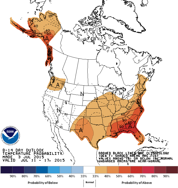
8 to 14 Day Temperature Outlook
According to NOAA's Climate Prediction Center, the 8 to 14 day temperature outlook suggests that areas in the Eastern U.S. and Alaska have a chance of warmer than average temperatures through mid July.
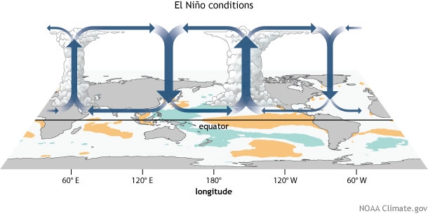
"How will El Niño affect 2015’s placement among the warmest years on record?"
Here's an interesting story from Climate.gov about how this year's El Nino could make for one of the warmest years on record:
"El Niño is characterized by, among other things, a large footprint of warmer-than-normal surface water across much of the tropical Pacific Ocean. This footprint contributes directly to warmer globally-averaged temperatures, in the same way that, if you leave one of your stovetop burners on “warm” the average temperature of the whole stovetop is warmer. But the warm footprint also adds heat to the atmosphere, just like the warm burner heats the air just above it. The atmosphere carries this along, reinforcing, over time, the direct heating from the “warm burner” in the tropical Pacific. Bringing it back to this year, this El Niño event, as it continues to take hold, will definitely increase 2015’s chances to place among the warmest years, if not the warmest, on record. We’ll touch base again towards the end of the year for a recap. Until then, I hope you’ve enjoyed going Beyond the Data."
See more from Climate.gov HERE:
______________________________________
"PGA meteorologist Brad Nelson keeps golfers safe"
Here's a neat story about my good friend and former classmate from St. Cloud State University, Brad Nelson, who works as a PGA meteorologist:
"A unique professional is in attendance at the Nova Scotia Open being held at Ashburn Golf Club. Not a golfer, caddie, or member of a television crew. No, Brad Nelson is a highly trained onsite meteorologist for Schneider Electric, contracted by the PGA Tour. It's his job to ensure that participants and spectators remain safe in the elements, and it can be challenging. Brad begins by telling me about the top weather hazard in golf. "The number one related hazard out here is definitely lightning." In order to aid him in lightning detection Brad brings a very specific instrument to the event. This is a CS-110 lightning detection system developed by Campbell Scientific. The instrument measures the electric charge in the atmosphere. As a storm approaches, the voltage measured by the unit increases and at a certain threshold, an alarm is issued. At that point shelter should be sought indoors. Can the onsite meteorologist and his lightning detection system make for a safer experience? So far the results say yes."
See the full story from CBC.ca HERE:
(image courtesy: CBC)

Thanks for checking in and have a great rest of your weekend and week ahead! Don't forget to follow me on Twitter @TNelsonWX

No comments:
Post a Comment