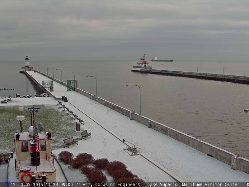
Here's one of my favorite views! The western most point of Lake Superior as seen by the the Lake Superior Marine Museum in downtown Canal Park in Duluth, MN. This was the scene early Monday morning with snow on the ground and along the pier.
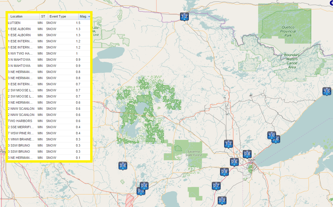
Sunday Night/AM Monday Snow Reports
According to the National Weather Service, there were a few 1"+ snowfall reports from PM Sunday/AM Sunday across parts of northeastern MN, enough to coat the ground in some spots.
________________________________
Easing into Winter. Thanksgiving Day Mess?
By Todd Nelson, filling in for Douglas
I've been adding more carrots to my diet recently, hoping that the benefits would counteract the lack of daylight we've been experiencing as of late. Sure, I thought I was on to something until my wife looked at me with a blank stare and kindly told me that it doesn't work that way. Carrots won't give me night vision. Well, at least I tried.
This can be a tough time of year for many as we adjust to the near 6 and a half hours of daylight lost since the Summer Solstice on June 22. The good news? We are less than 1 month away from the Winter Solstice on December 22, then days will slowly get longer!
Keep in mind that we're currently sitting at our 7th wettest November on record at MSP with precipitation chances increasing just in time for holiday travels. It appears that light rain/drizzle on Wednesday may transition to light snow by Thanksgiving across parts of the Upper Midwest. While it doesn't appear that any major accumulations will settle in close to home, another system late this weekend could bring a light coating.
________________________________
MONDAY NIGHT: Mostly cloudy, quiet and chilly. Winds: WNW 5. Low: 26.
TUESDAY: Warmer. Clouds thicken late. Winds: SE 10-15. High: 42.
TUESDAY NIGHT: Becoming mostly cloudy. Winds: SE 10-15. Low: 32.
WEDNESDAY: Cloudy and damp. Light rain/drizzle changing to light snow later. Winds: S 10. High: 45.
THURSDAY: Cool breeze, light snow south. Winds: NNW 10-15. Wake-up: 32. High 36.
FRIDAY: Bright sun. Perfectly average for November. Winds: N 5-10. Wake-up: 22. High: 34.
SATURDAY: Drier day of the weekend. Winds: WSW 5. Wake-up: 20. High: 35.
SUNDAY: Clouds thicken, light snow late. Winds: SE 10. Wake-up: 24. High: 34.
MONDAY: Chance of snow. Some accumulations? Winds: NNW 10-15. Wake-up: 24. High: 32.
__________________________________
This Day in Weather History
November 24th
1993: The Thanksgiving Day Blizzard of 1993. A slow moving storm system traveled across the Upper Midwest during the Thanksgiving holiday, causing heavy snow across most of Minnesota. Travel became extremely difficult if not impossible over west central Minnesota where over a foot of snow accumulated. A number of car accidents were reported and several community events were canceled. Snowfall in excess of six inches or greater occurred north of a line from Bricelyn (Faribault County) to the Twin Cities metro area.
1983: A snowstorm dumps almost two feet at Babbitt and about 20 inches at Duluth.
1825: A warm spell begins over Ft. Snelling. The temperature rises up to 70 degrees.
____________________________________
Average High/Low for Minneapolis
November 24th
Average High: 36F (Record: 59F set in 2011)
Average Low: 22F (Record: -10F set 1893)
_____________________________________
Sunrise/Sunset Times for Minneapolis
November 24th
Sunrise: 7:22am
Sunset: 4:37pm
*Daylight: ~9 hour and 14 minutes
*Daylight Lost Since Yesterday: ~1 minute and 57 seconds
*Daylight Lost Since Summer Solstice: ~6 hours and 22 minutes
______________________________________
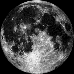
Moon Phase for November 24th at Midnight
0.7 Days until Full (Beaver) Moon
"Full Beaver Moon, Nov. 25, 5:44 p.m. EST — Time to set beaver traps before the swamps freeze to ensure a supply of warm winter furs. Another interpretation suggests that the name Beaver Full Moon comes from the fact that the beavers are now active in their preparation for winter. It is also called the Frosty Moon."
See more from Space.com HERE:
____________________________________________
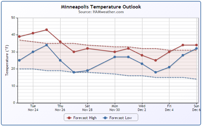
Minneapolis Temperature Trend
After one of our first bouts of chilly weather this season, temperatures look to warm through midweek as a storm system approaches from the west. Readings look to climb back into the 40s through Wednesday before we dip to slightly below average levels again this weekend.
____________________________________________
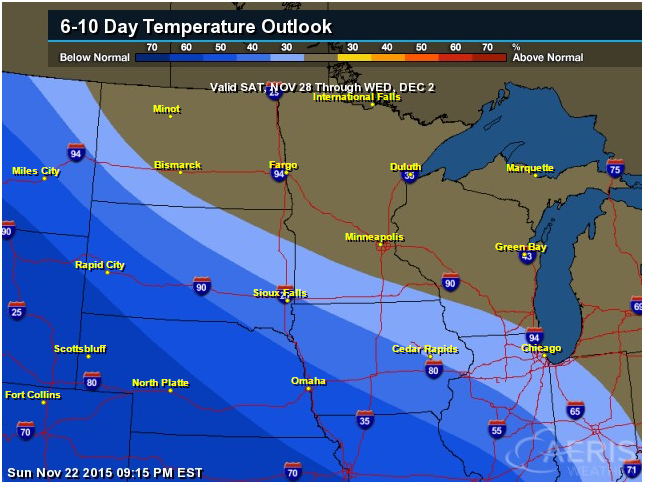
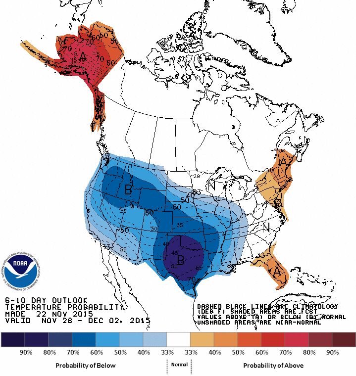
6 to 10 Day Temperature Outlook
According to NOAA's CPC, the 6 to 10 day temperature outlook suggests cooler than average temperatures across much of the Midwest by the end of the month/start of December.
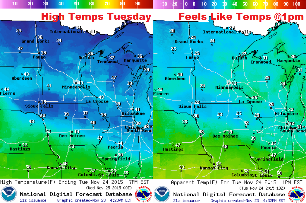
Tuesday Weather Outlook
40s might actually feels fairly mild considering how chilly it was over the past few days. Keep in mind that with the wind, it will feel more like the 20s and 30s across the state.
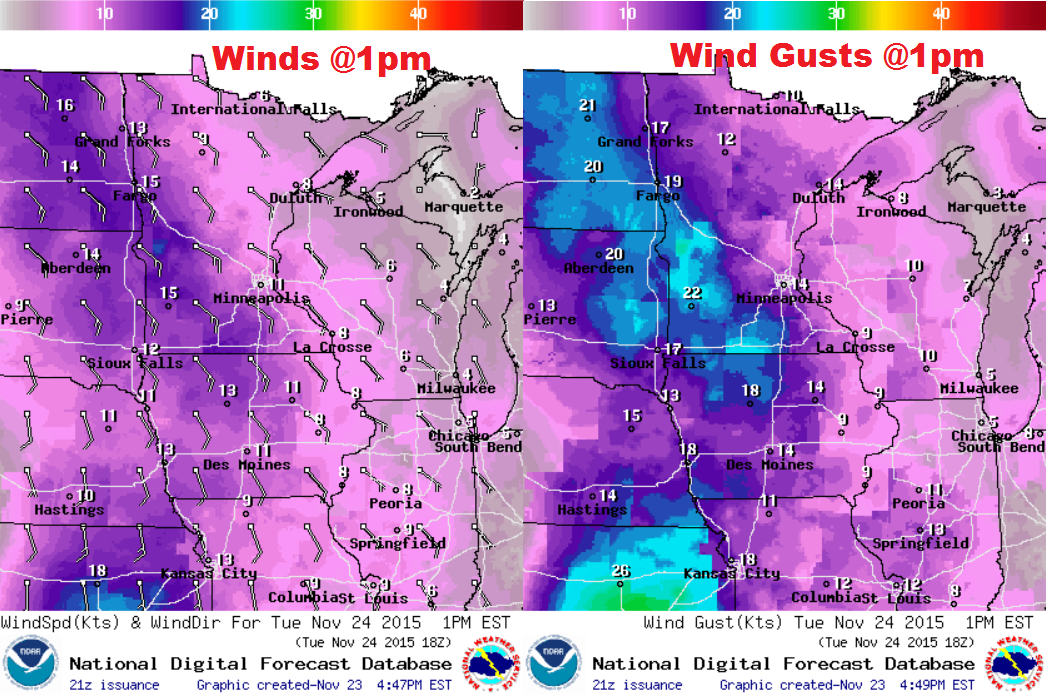
Tuesday Weather Outlook
Wind speeds will be a little stronger on Tuesday ahead of a develop storm system that will spread moisture into the region by Wednesday. Some of the winds could gust to near 20mph+ across the western/southwestern part of the state.
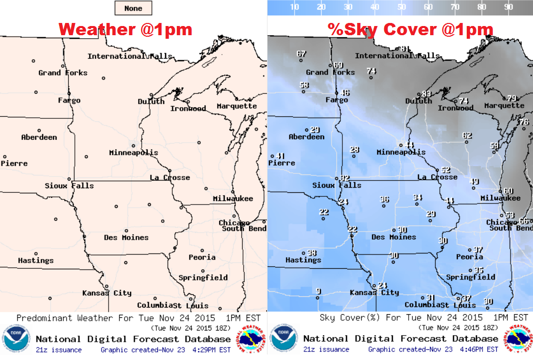
Tuesday Weather Outlook
While Tuesday looks to remain dry, there will be a few more clouds across the northern half of the state much of the days. Also, clouds look to increase overnight Tuesday into Wednesday ahead of a develop storm system that will start producing precipitation around the region Wednesday/Thursday.
________________________
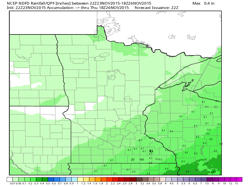
Precipitation Outlook Through 12pm Thursday
Weather conditions will still be dry on Tuesday, but light rain/drizzle looks to develop on Wednesday, some of which could be a little mix across the northern half of the state. Lingering light snow may be possible across the southeastern part of Minnesota and into Wisconsin on Thursday. However, note that precipitation values don't look all that impressive.
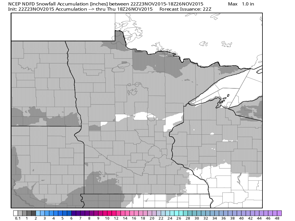
Snowfall Potential Through 12pm Thursday
While snow accumulations don't look major, there may be some accumulations starting across parts of the state through 12pm Thursday. However, much of the accumulations look light.
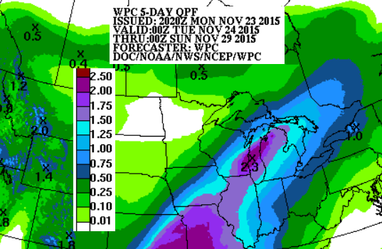
5 Day Weather Outlook
According to NOAA's WPC, the 5 day precipitation outlook across the Midwest suggests heavier precipitation amounts south of Minnesota into the Great Lakes Regions. Keep in mind that much of this moisture will fall in a liquid fashion with only a little snow on the extreme northwestern flank of the system.
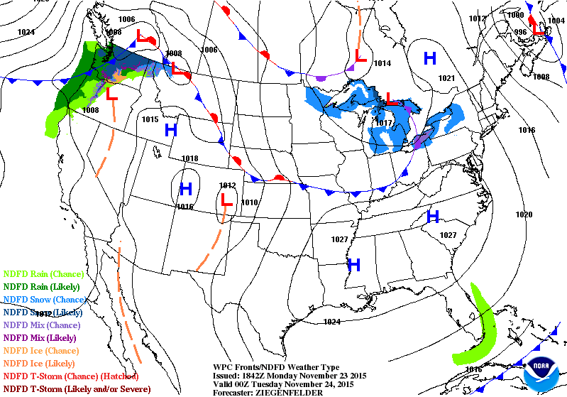
National Weather Outlook
Here' a look at our storm system as it pushes into the western half of the country through midweek. Note that some of the heaviest snow will be found in the high elevations across the Western U.S. with some of the heaviest rains developing in the Central U.S. by midweek.
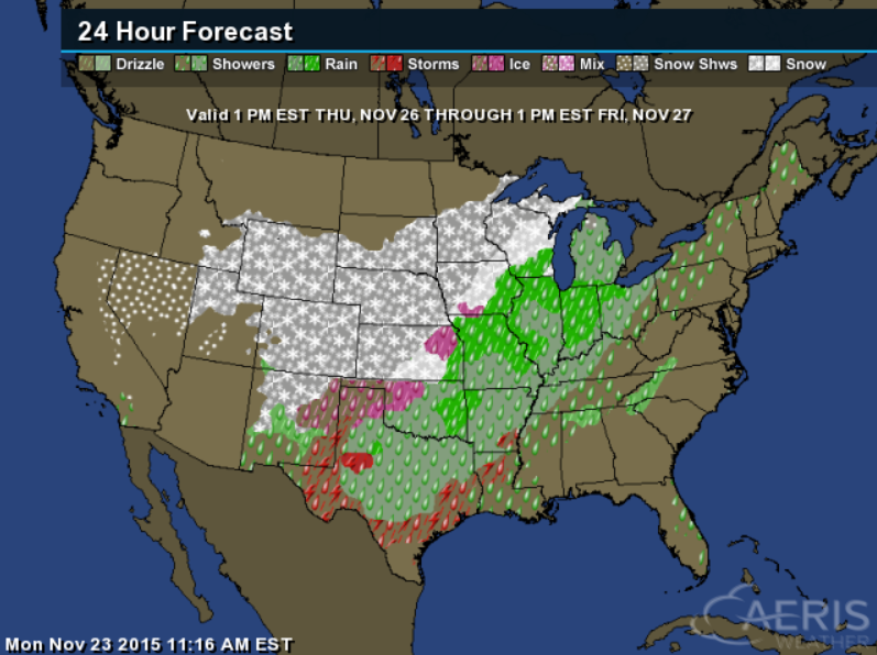
Thanksgiving Day Outlook
As the storm system spreads east, Thanksgiving day could be a little messy across the Central U.S.. Expect a few travel impacts where wintry precip falls and perhaps even across the South-Central U.S., where heavy rain and storms will be found.
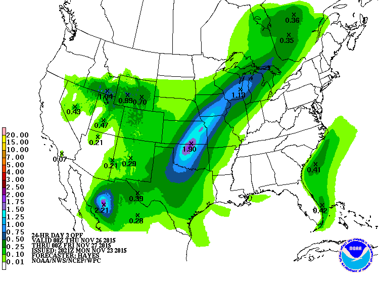
Precipitation Outlook on Thanksgiving Day
According to NOAA's WPC, the precipitation outlook from 6pm Wednesday to 6pm Thursday suggests the heaviest rainfall across parts of the Plains. Some spots could see as much as 1" to 2" in just that 24 hour period!
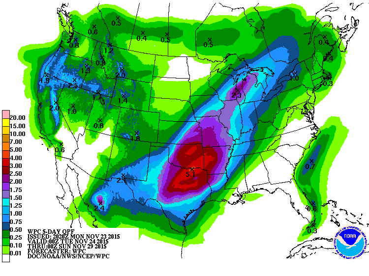
5 Day Precipitation Outlook
According to NOAA's WPC, the 5 day precipitation outlook suggests another round of heavy rainfall across parts of the south-central U.S. the week. Some of this could lead to localized areas of flooding. Keep in mind that some of the heaviest may fall near Oklahoma City, OK where they are currently sitting at their 4th wettest year on record, with nearly 49" of precipitation (14.62' above average)! The additional rainfall this week could continue to add to already impressive tallies there!
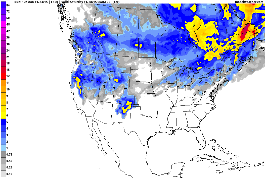
5 Day Snowfall Forecast
Here's the 5 day snowfall forecast across the country. Note that the heaviest appears to be across the Western U.S., especially in the higher elevations, while a little accumulations may be possible across parts of the Midwest/Great Lakes Region later this week.
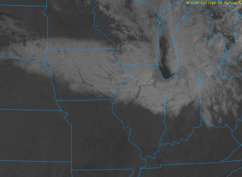
Snow From Space
This is kind of neat! The recent snowfall event late last week/weekend across parts of the Plains/Great Lakes can be seen from the visible satellite! This is what the visible satellite image looked like on Monday morning.
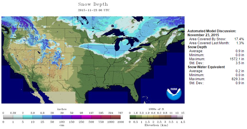
National Snow Coverage: November 23, 2015
According to NOAA's NOHRSC, 17.4% of the nation was covered in snow as of Monday, November 23rd, mainly across the high elevations in the Western U.S. and parts of the Midwest/Great Lakes.
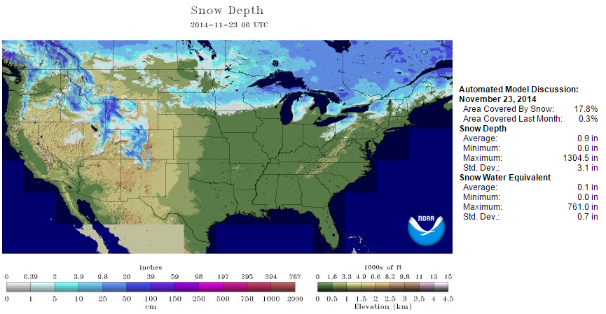
National Snow Coverage: November 23, 2014
At this time last year, 17.8% of the nation was covered in snow, nearly in some of the same spots!
________________________________
6 to 10 Day Temperature Outlook
According to NOAA's CPC, the 6 to 10 day temperature outlook suggests a fairly large chunk of colder than average temperatures moving in to the western half of the country by the end of the month/early December. Some of the temperatures could be well below average!
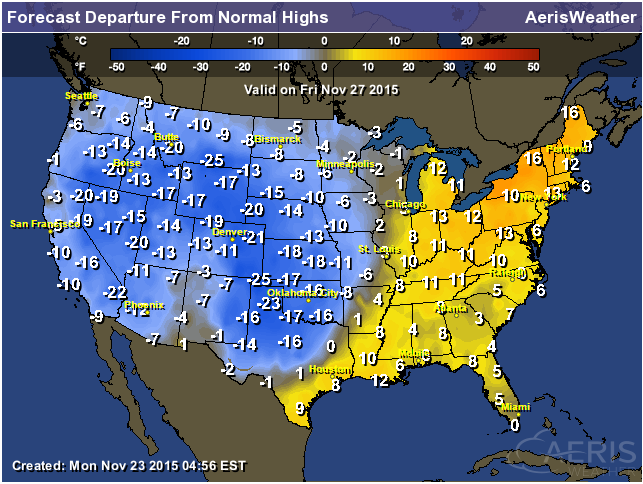
Highs From Average Friday
Post storm system, temperatures will take a BIG hit across the western half of the country with reading falling to near 10F to 20F+ below average! Meanwhile, ahead of the storm system, temperatures will still be nearly 10F to 15F above average east of the Mississippi River!.
Thanks for checking in and have a great rest of your week! Don't forget to follow me on Twitter @TNelsonWX

No comments:
Post a Comment