Happy New Year for Travelers - December Was Warmest on Record, Statewide
19 F. high in St. Cloud New Year's Eve. 22 F. average high on December 31. 17 F. high on December 31, 2014.
4 minutes of additional daylight in the Twin Cities since December 21st's Winter Solstice. January 1, 2003:
On this date there is an inch or less of snow on the ground from Duluth
to the Iowa border. In the Twin Cities there isn't even a dirty
snowbank to be found. January 1, 1997:
Freezing rain causes numerous accidents along the North Shore. In Lake
County, vehicles could not get up hills and were blocking roads. Highway
61 was closed for several hours from Two Harbors to Silver Bay. January 1, 1864: Extremely cold air moves into Minnesota. The Twin Cities have a high of 25 degrees below zero.
Happy 2016! - Historic December - Risk of a January Thaw
My
New Year's resolutions are simple: a healthy right ankle, inventing new
ice-proof shoes, having my wife walk the dog during the winter months,
and not blaming everything on El Nino.
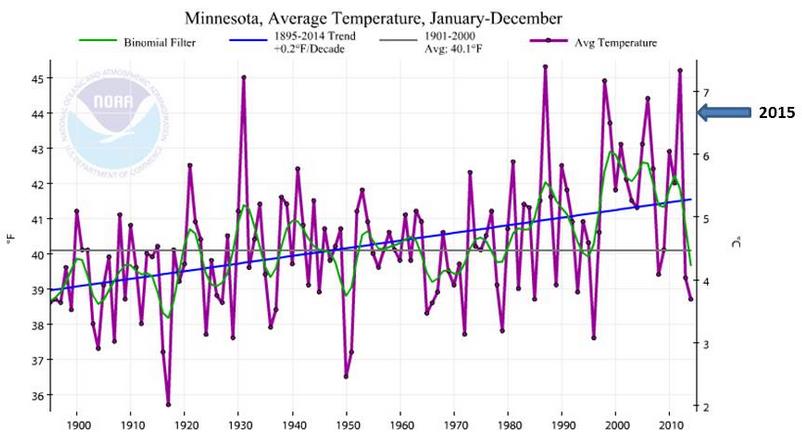
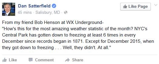
December was the warmest
and the second wettest on record, statewide, according to Dr. Mark
Seeley. 2015 was the 21st wettest year on record, statewide.
Second
warmest autumn, a glorious summer, interrupted by a few spasms of
severe weather, including an epic straight-line wind event on July 12 at Gull Lake. Smoke from western fires swept over Minnesota much of the summer, resulting in a cloak of haze.
January
is the coldest month of the year and there are signs the AO (arctic
oscillation) is going negative, meaning a better chance of polar air
splashing into the USA. We'll see our fair share of cold fronts this
month, but it probably won't be as numbing as recent years, thanks to El
Nino.
The sun peeks out today; near 30F Saturday - maybe 3 days above 32F next week. A welcome January Thaw may give way to a couple subzero nights in 2 weeks.
Faint echoes of muscular winters gone by.
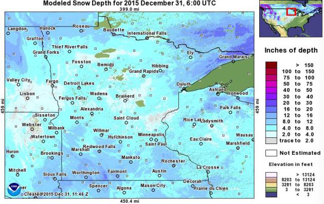
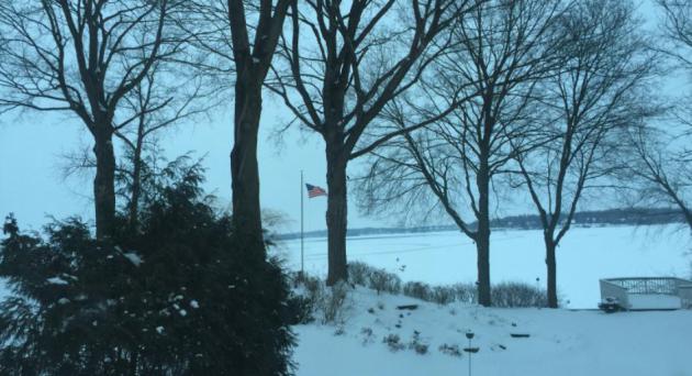
New Year's Eve Snow Cover.
It's still slim pickings out there for snow, especially north toward
Mille Lacs and the Brainerd Lakes area, where many spots only have a
couple inches of (dirty) snow on the ground. Monday's storm dropped
significant amounts over southern Minnesota, with 5" on the ground in
the Twin Cities and as much as 8-10" from near Rochester and Owatonna to
Mankato, Fairmont and Marshall. There's ample snow along the North
Shore and far northern Red River Valley, the snowfall deficit for the
season, to date, continues across most of Minnesota. Source: NOAA. December: Warmest, Second-Wettest Ever Recorded for Minnesota. Here's an excerpt from Dr. Mark Seeley's latest installment of Minnesota WeatherTalk: "For
the 4th consecutive month Minnesota recorded warmer than normal
temperatures. Observers reported mean monthly temperatures for December
that were from 8 to 12 degrees F above normal, marking the warmest
December in history on a statewide basis, surpassing the previous record
from December 1939. Extremes for the month ranged from 53F at Marshall
on the 9th to -11F at Thief River Falls on the 28th. On a statewide
basis December of 2015 was the 2nd wettest in history, with an average
value of nearly 1.90 inches. Some observers reported their wettest
December in history, including: 4.09" at Two Harbors; 4.90" at
Caledonia; 5.38" at La Crescent; 4.28" at Preston; and 4.00 inches at
Spring Grove..."
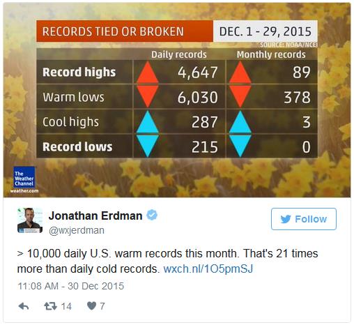
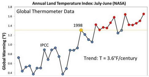
Two Charts Show December's Crazy Warmth. Climate Central takes a look at historic warmth in December: "...The month is likely to be the hottest December on record for most, if not all, states to the east of the Mississippi, capping off a year that is virtually a lock to be the world’s hottest on record.
As the first chart, from the Weather Channel, shows, there were about
10,000 combined daily record highs and record warm lows compared to just
around 500 record cold highs and lows this month — a ratio of about
21-1. The higher ratio of record highs to lows
is a hallmark of global warming, which skews the odds in favor of the
former. Without warming, the ratio would be about 1-to-1, at least on
the scale of years or decades. But over the past two decades, those
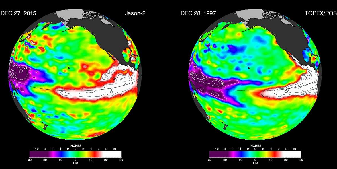
figures have tilted 2-to-1 in favor of record heat..." El Nino: Why Predictable Climate Event Still Has The Scientists Guessing. Every El Nino is different, it turns out, and this one already rivals 1997-98. Here's an excerpt from The Guardian: "...The
last great El Niño, in 1997-98, helped make 1998 the then warmest year
on record – that too was accompanied by a series of devastating events
around the world, among them ice storms in North America, floods on the
west coasts of the Americas and forest fires in Borneo. It also delayed
the monsoon rains in India, warmed tropical waters so severely that
coral reefs started to “bleach” and die, and signalled a record-breaking
season of typhoons and tropical cyclones in the eastern Pacific.
Although researchers are fairly sure that climate change as a
consequence of the combustion of fossil fuels, and the release of
greenhouse gases, could make El Niño more frequent, or more devastating,
or both, it remains a natural, cyclic event..."
Graphic credit above: "False-color
images provided by Nasa compare Pacific Ocean water temperatures from
the El Niño in 1997 (right) and the current El Niño." Photograph: AP.
Freakish Weather From the North Pole to South America.
How much of what we're witnessing is El Nino, the AO (arctic
oscillation) or something more, symptoms of a much broader warming of
the atmosphere and oceans? Here's an excerpt at The Washington Post: "...Whether
the latest events can be linked to climate change will remain a
question mark until research can be done, said Jeff Masters, the
founding meteorologist of the weather website Weather Underground. “We
have trouble making that connection in real time, because we have
trouble teasing out the natural variability from the human-caused
forcing,” Masters said Wednesday. “It’s really hard to scientifically
say that’s what’s going on.” Yet after decades of studying and analyzing
global weather extremes, Masters thinks the shift is obvious. “This
isn’t the climate I grew up with,” he said. “We didn’t see this kind of
weather in the 20th century. It’s just a continuation of the crazy
weather we’ve seen over the course of the 21st century so far...”
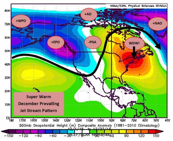
Washington D.C. Eclipses Warmest December on Record by Enormous Margin. Here's an excerpt of a timely explainer from Capital Weather Gang that delves into some of the reasons (beyond El Nino), including the AO and NAO: "...A
combination of the strongest El Niño on record (by some measures) and a
few other factors drove the super-warm pattern over eastern North
America. The prevailing jet stream featured an incredible, warm ridge of
high pressure over the entire eastern half of the continent — a
complete reversal from last year’s winter pattern.All of these
large-scale patterns worked together to create impressive warmth in the
Eastern United States.
+WPO Positive Western Pacific Oscillation (warm Eastern U.S. signal) +EPO Positive Eastern Pacific Oscillation (warm Eastern U.S. signal) -PNA Negative Pacific-North American (warm Eastern U.S. signal) +AO Positive Arctic Oscillation (normally a warm Eastern U.S. signal) +NAO Positive North Atlantic Oscillation (normally a warm Eastern U.S. signal)
The resulting surface temperature anomaly was astonishing..."
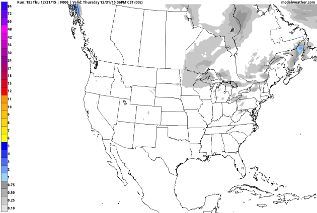
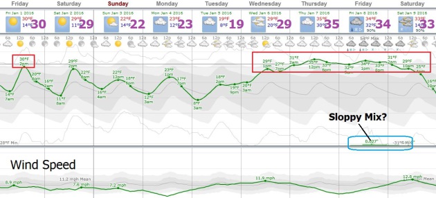
No Accumulating Snow Until (maybe) Late Next Week.
We're now in a quiet pattern with a bubble of Canadian high pressure
settling over the Upper Midwest, increasing the potential for sunshine, a
rare commodity in early January. We warm close to 30F Saturday before
cooling slightly early next week; the approach of milder air the latter
half of next week may set off a couple inches of snow or a sloppy mix
roughly one week from now, according to GFS guidance. 10-Day snowfall
estimates: NOAA and AerisWeather.
Still Trending MIlder than Average.
In spite of a cool-off early next week temperatures fairly consistently
run above average for early January, the best chance of a thaw the
latter half of next week. The first chance of a little snow or a messy
mix will be Thursday and Friday of next week. Source: WeatherSpark.
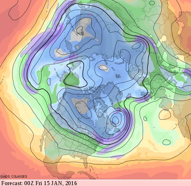
Seasonably Cold.
Unusually mild air forecast to stretch from Alaska to the North Pole
will help to displace the polar vortex farther south, pumping a series
of colder fronts south of the border by mid-January, but if this
forecast verifies the pattern won't favor major storms (we need a
lingering trough of low pressure in the western USA to eject a series of
moist storms northward). The flow looks cold (teens and 20s) but not
polar, not yet. Source: GrADS:COLA/IGES.
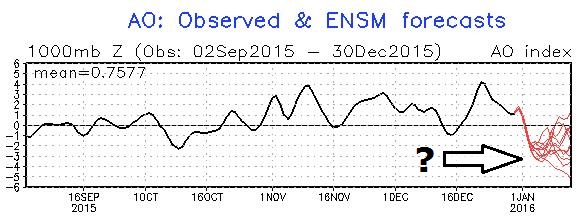
In Wild Winter, Warm Arctic Storm Chills U.S. Forecast as Flooding Threatens Levees.
From Missouri to Britain severe flooding is taking a mounting toll, but
there are signs a tight polar vortex may be about to break down as the
AO (arctic oscillation index above) goes from positive to negative,
weaker winds allowing colder air to surge farther south, into the USA
and Europe later in January. Here's an excerpt from Andrew Revkin at The New York Times: "...The
outcome will depend on how an atmospheric tussle plays out — one well
captured nicely in the title of a post by Brenda Ekwurzel, senior
climate scientist at the Union of Concerned Scientists: “El Niño vs. the Arctic: Which Will Dominate This Year’s Winter Weather?” She wrote:
However, there may be a need to keep those winter coats in the front of the closet. Some scientific indicators suggest a January 2016 weakening of the stratospheric polar vortex, increasing the chance for severe late winter weather over the continents..."
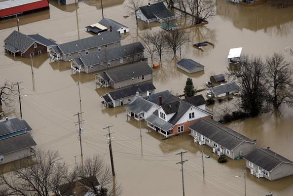
In Midwest, 1,000 Flood-Fighters Work To Hold Back New Year's Floods. CSMonitor.com has an update on Mississippi River flooding now rivaling 1993's epic flood. Here's an excerpt: "With
the Mississippi River and four other major US rivers building toward
historic crests for a winter flood, some 1,000 US flood fighters have
spread out across America's mighty river valleys to once again test the
wherewithal of the world's grandest plumbing works: the Mississippi
River and Tributaries project. El Niño conditions in the Pacific have
created an unusually wet and warm mess across the nation's midsection
and into the Deep South. The gauge at St. Louis is clawing up toward 42
feet, its third-highest in recorded history. Parts of St. Louis are
already underwater as the confluence of the Missouri River and the
Mississippi roil the city's shipping front and close the St. Louis
harbor. The waters are expected to crest in Missouri on New Year’s Day..."
Photo credit above: "Homes
are surrounded by floodwater in Pacific, Mo., Wednesday. A rare winter
flood threatened nearly two dozen federal levees in Missouri and
Illinois on Wednesday as rivers rose, prompting evacuations in several
places." Jeff Roberson/AP.
CNN has more details on the potentially historic flooding around St. Louis here.
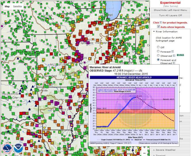
Track the Flooding.
You can click on any one of the rain gauges in NOAA's network to get a
current and predicted flood crest; in a few areas around St. Louis
crests may exceed 1993. Map: NOAA's Lower Mississippi River Forecast Center. Death Toll Rises in Missouri Floods, Threat Not Over.
Historic December rains falling on partially frozen ground and running
off into tributaries has tipped the Mississippi River to flood stages
not seen since 1993. Here's an excerpt from NBC News: "... (Governor)
Nixon declared a state of emergency on Monday and activated the
National Guard on Tuesday. He pledged help for inundated towns.
President Barack Obama called Nixon for a briefing on the situation
Wednesday, and directed his staff to coordinate with the state on any
federal assistance required, the White House said. "We are here before
the water rises, we're here after it falls," Nixon said. "We're here
until this place is back to where it was before. And sometimes that
takes a while." Parts of the Meramec River were between two and three
feet higher than during a devastating flood in 1993, which is also known
as the "great flood," Nixon said. The Mississippi River at Thebes,
Illinois, reached two feet higher than in 1993, he said..."
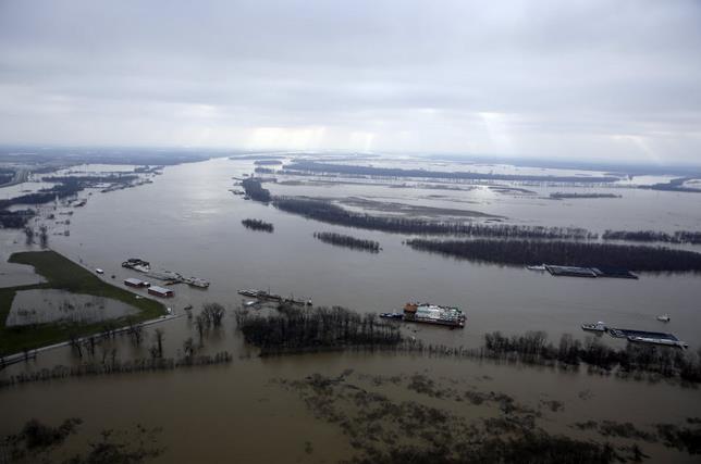
Photo credit above: "In
this aerial photo, the Mississippi River flows out of its banks
Wednesday, Dec. 30, 2015, near West Alton, Mo. A rare winter flood
threatened nearly two dozen federal levees in Missouri and Illinois on
Wednesday as rivers rose, prompting evacuations in several places." (AP Photo/Jeff Roberson)
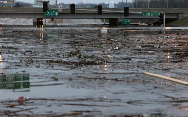
Worst Flooding in St. Louis Area in More Than 20 Years. Interstate 44 is still shut down because of flood waters; here's an excerpt of a comprehensive update at St. Louis Post-Dispatch: "The
St. Louis region is grappling with the most extensive flooding seen in
more than 20 years. Record rainfall over the weekend and Monday have
ended, but area rivers keep rising..."
Photo credit above: "Water swells on Highway 141 underneath a closed Interstate 44 overpass on Wednesday, Dec. 30, 2015." Photo by Robert Cohen.
* U.S. Army Corp of Engineer flood-fighters are now fully engaged. Details here.
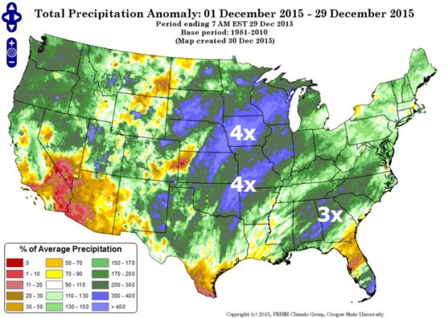
More April than December.
Check out the precipitation anomaly map for December, to date, showing 4
times more rain than average across a huge swath of territory from
Wisconsin into central Iowa and eastern Nebraska; another soggy
bulls-eye from Tulsa to St. Louis. It's unusual to see such a large area
over the USA east of the Rockies so wet in December; a function of El
Nino and a warmer atmosphere able to hold more water vapor. Source:
PRISM Climate Group, Oregon State University.
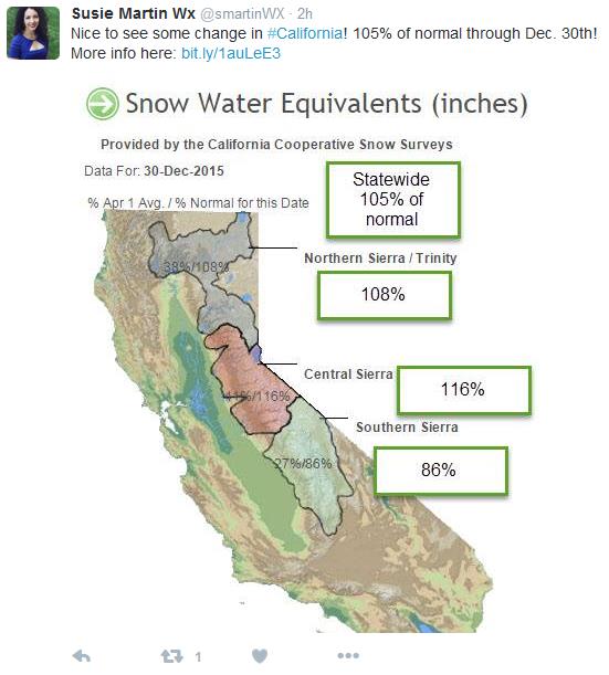
El Nino's Silver Lining.
The firehose of moisture from El Nino has been trained on the Pacific
Northwest, but there are signs the storm track will shift southward in
the coming weeks, putting California in the potential cross-hairs of
flooding rains and mudslides. December precipitation (rain and snow) was
higher than average across most of the state, still in the grips of
extreme drought.
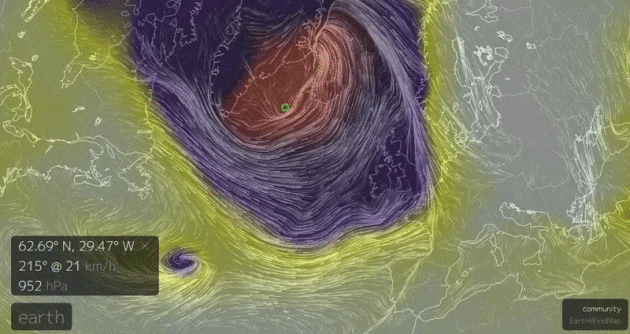
Historic Storm Set to Slam Iceland, Northern UK with Hurricane-Force Winds. Andrew Freedman at Mashable
has a good overview of a wild storm bringing the prospect of more wind,
wave and flood damage - and record warmth for the North Pole; here's
the intro: "One of the strongest storms on record to form in the
North Atlantic is set to rock Iceland with winds above hurricane force
by Wednesday. It's also expected to drive a new batch of rain and wind
to flood-weary areas of the UK. The storm could even set an all-time
record for the strongest storm to develop in this part of the North
Atlantic. The storm will be a meteorological marvel, intensifying so
rapidly that the term "bombogenesis" is perhaps an understatement to
describe its intensification. Aiding its explosive development is a jet
stream on steroids, with winds of 230 miles per hour roaring across the
North Atlantic at aircraft cruising altitudes..." (Image: earth.nullschool.net)
10 of the Wildest Weather Stories of 2015.
You'll remember many of these jaw-dropping moments, highlighted by
Boston's mega-snows and historic flooding across the Deep South; here's
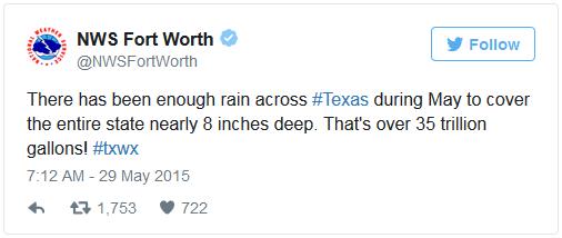
an excerpt from wisc.com and Sinclair Broadcast Group: "...Texas and Oklahoma faced their wettest month on record in May 2015, with both states far exceeding their previous records
for total rainfall. According to the National Weather Service, Texas
was hit with enough rain to cover the entire state in 8 inches of water.
The worst of the rainstorms around
Memorial Day delivered fatal floods in Texas, Oklahoma, and Arkansas.
Flooding earlier in the month caused an estimated $210 million in damage
in Nebraska. In total, at least 40 deaths were blamed on southern
flooding in May, according to the Weather Channel. President Obama declared a major disaster as storms bore down on Texas, causing evacuations, damage, and death..."
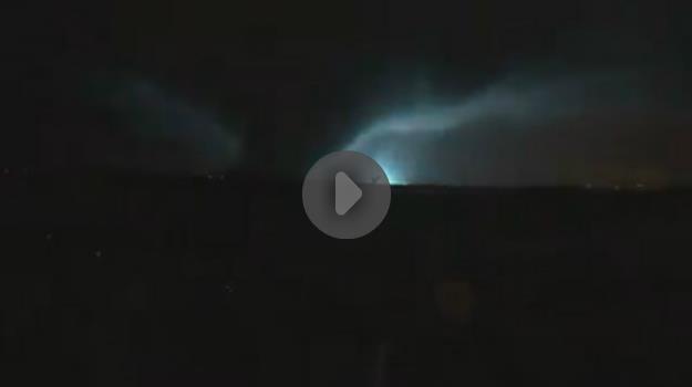
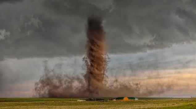
Video: Man Records Tornado's Approach, Aftermath. KLTV
in Tyler Texas has a link to some remarkable footage taken as a massive
tornado tore through the east suburbs of Dallas; here's an excerpt: "A
series of heartbreaking videos from a man who recorded a tornado in the
Dallas-area is gaining shares on Facebook. The videos were posted by
Randy Pritchard. Recording from what appears to be a cellphone,
Pritchard captured video of the tornado as it made its way across a lake
and toward the neighborhood. He was standing outside with friends when
the storm struck and caught images of lightning strikes and the massive
funnel cloud. The group rushes to the neighbor’s house as the storm
nears and gathers in his shelter..." (Rated PG for rough language). Picture of Eastern Colorado Tornado Wins National Geographic Photo Contest. Here's the intro to an explanation at NatGeo: "A
picture of a tornado that touched down 50 miles northeast of Colorado
Springs last summer has been chosen as the grand-prize winner of the
2015 National Geographic Photo Contest. The winning twister was one of
as many as five tornadoes that touched down in the Simla area on June 4,
damaging sheds, barns and outbuildings. The photograph was captured by
James Smart of Melbourne, Australia. Smart took the award winning
picture on the last day of a 15 day storm chasing tour..."
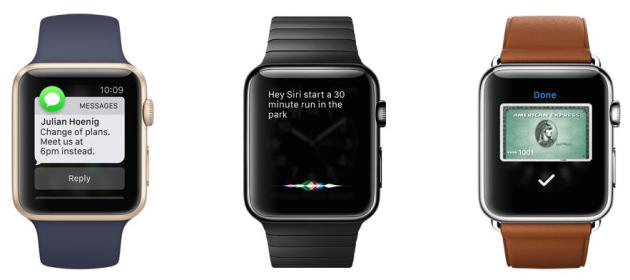
With Taps on the Wrist, Apple Watch Points to the Future. Just another gadget, or something more profound? This tech writer at The New York Times is pretty sold; here's an excerpt: "...And
yet, after almost eight months, the Apple Watch feels like the future
to me. More than anything else, the watch has changed the way I
communicate via email and text messages. Using Apple’s VIP feature, I
direct all of the most important messages to my watch, which alerts me
with a subtle tap on my wrist or a soft ding. I ignore most after a
quick glance. (Sorry, Mom.) Many get a quick “O.K.” or “Sounds good.” I
pull out my phone only for the ones I need to respond to at length. The
same is true for phone calls, which appear on my watch while my phone
remains tucked away in my pocket, or still at my desk on the other side
of the office. It’s like Caller ID for my wrist..."
Want to Succeed at Keeping Your New Year's Resolution? Try This. Keep your expectations low and you'll never be disappointed! Actually, this article at Quartz makes a lot of sense, here's a clip: "...Psychologists
say that one of the biggest reasons we cannot stick to our new year
resolutions is because we choose resolutions that are radically different from our current lifestyle.
For instance, one of the most common resolutions is to lose weight, or,
in case of smokers, to stop smoking. Keeping resolutions is about the art of self-control,
which decades of research have shown is a limited resource. The
resolutions we choose tend to be big goals, and thus they require a lot
of self-control. As a result, these resolutions are also the easiest
ones to give up on..."
NEW YEAR'S DAY: Partly sunny, brisk. Winds: W 10-15. High: 26
FRIDAY NIGHT: Mostly clear and chilly. Low: 10
SATURDAY: Plenty of sun, a bit milder. Winds: NW 8-13. High: near 30
SUNDAY: Blue sky, milder than average. Winds: N 8-13. Wake-up: 11. High: 28
MONDAY: High pressure overhead, light winds with some sun. Wake-up: 16. High: 29
TUESDAY: Fading sun, windy and milder. Wake-up: 18. High: 32
WEDNESDAY: More clouds than sun, thawing out. Wake-up: 23. HIgh: 33
THURSDAY: Overcast, light mix possible late. Wake-up: 29. High: 34
Climate Stories...
“...What
is most unfortunate,” said Farrell, the Yale sociologist, “is that
polarization around climate change was manufactured by those whose
financial and political interests were most threatened.” Even today, he
added, that polarization has crippled any hopes for bipartisan policy
solutions.... "
Climate Chaos, Across the Map. Justin Gillis at The New York Times
tries to connect the dots between weather volatility, ENSO (El Nino)
and larger planetary trends. As always, trying to prove cause and effect
with the atmosphere is problematic, but are we inadvertently loading
the dice in favor of more extremes, especially with rainfall and heat?
Here's an excerpt: "...In both the Atlantic and Pacific, the
unusually warm ocean surface is throwing extra moisture into the air,
said Kevin Trenberth, a climate scientist at the National Center for
Atmospheric Research in Boulder, Colo. Storms over land can draw
moisture from as far as 2,000 miles away, he said, so the warm ocean is
likely influencing such events as the heavy rain in the Southeast, as
well as the record number of strong hurricanes and typhoons that
occurred this year in the Pacific basin, with devastating consequences
for island nations like Vanuatu. “The warmth means there is more fuel
for these weather systems to feed upon,” Dr. Trenberth said. “This is
the sort of thing we will see more as we go decades into the future.”
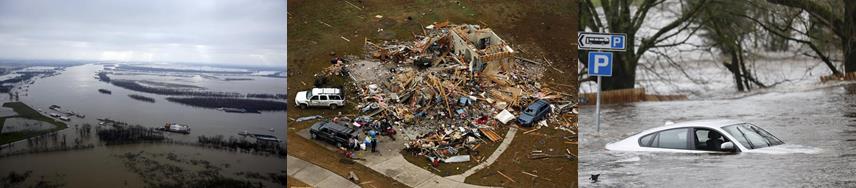
Photo montage credit,
left to right: Missouri flooding: AP Photo/Jeff Roberson; Dallas area
tornado: G.J. McCarthy/The Dallas Morning News via AP; Scotland
flooding: Danny Lawson/PA via AP.
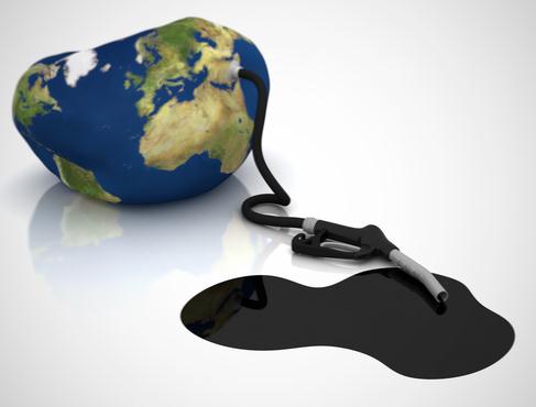
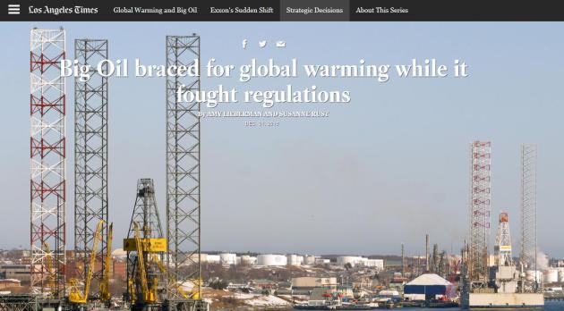
Big Oil Braced for Global Warming While It Fought Regulations.
Because a little organized, manufactured misinformation can be good for
the bottom line, at least in the short-term. But truth usually catches
up with you, and now the question is what the fossil fuel industry knew,
when they knew it, and how they communicated inherent climate risk to
the general public vs. internal, strategic purposes. The Los Angeles Times continues their reporting; here's a snippet of the most recent article: "A
few weeks before seminal climate change talks in Kyoto back in 1997,
Mobil Oil took out a bluntly worded advertisement in the New York Times
and Washington Post. “Let’s face it: The science of climate change is
too uncertain to mandate a plan of action that could plunge economies
into turmoil,” the ad said. “Scientists cannot predict with certainty if
temperatures will increase, by how much and where changes will occur.”
One year earlier, though, engineers at Mobil Oil were concerned enough
about climate change to design and build a collection of exploration and
production facilities along the Nova Scotia coast that made structural
allowances for rising temperatures and sea levels..."
Buss: GOP Should Rethink Climate Change. Here's an excerpt of an Op-Ed at The Detroit News: "...Meantime,
unless Republicans find a way to talk about climate change that doesn’t
make them sound out of touch, GOP presidential candidates will continue
to struggle to relate to the average voter on this issue. Almost every
poll shows younger voters believe some degree of climate change is
taking place, and that human activity significantly contributes to its
severity. A majority of all Americans believe that as well. That means
it’s an issue the Republican Party must get a handle on, particularly if
it wants to be the party of the future. Conservative candidates don’t
lead the conversation on climate change, largely because they don’t
believe there’s anything to discuss. Instead, progressives and their
Democratic candidates control the conversation and make everyone else
out to sound medieval..."
Tire Execs Call for Action on Climate Change. I found this interesting, a story at Tire Business
(what, you don't read Tire Business?) No shame in that, but this is
part of a broader trend among business leaders who want to go on the
offensive: "...In an open letter to Congress they are urging the
U.S. government to follow through on the agreements reached during the
recent United Nations Climate Change Conference in Paris. The tire
executives who signed the letter, published on The Hill, the Congressional blog that serves as a forum for lawmakers and policy professionals, are:
Gary Garfield, CEO and president of Bridgestone Americas Inc.;
Pete Selleck, chairman and president of Michelin North America Inc.;
Pierluigi Dinelli, chairman and CEO of Pirelli Tire North America Inc.;
James Hawk, chairman of Toyo Tire Holdings of Americas Inc.; and
Takaharu Fushimi, CEO and president of Yokohama Tire Corp..."
Think Global Warming is a Scam? Take the $25,000 Bet.
My hunch is, in spite of all the bluster and flame-mail, there won't be
many takers. Here's an excerpt from physicist and climate scientist
Mark Boslough at Huffington Post: "...Those who reject mainstream climate science have a bully problem. They talk big. They harass and threaten scientists. They publish angry anti-science blogs and vitriolic editorials. Deniers with political power issue subpoenas, file investigative demands, and even hold kangaroo hearings.
The lightweights write anti-science letters to the editor of local
newspapers, tweet insults, swarm people on social media, and send hate mail.
They all claim with utter certainty that there is no possibility of
serious risk from human-caused global warming. Yet when it comes to
taking a personal risk to prove they mean it, they back down. Like all
bullies, they are cowards. The worst bully on the block is the Heartland Institute, a fossil-fueled anti-science pressure group based in Chicago..." U.S. Views on Climate Change Pose Test for 2016 Candidates. Financial Times
explains the paradox: Americans are increasingly concerned, but wary if
taking action imposes costs. If the GOP candidate denies the science
swing voters may be turned off, if the Democratic nominee has a road map
for action that is deemed too costly or "job-killing" there may be a
similar backlash. Here's an excerpt from Financial Times: "Barry
Rabe, who has done extensive analysis of opinion polls, says: “All the
evidence suggests there is growing concern about this issue, but limited
evidence that that translates to any groundswell of support for any
particular policy, especially one that imposes costs.” Mr Rabe, a public
policy professor at the University of Michigan, says the lack of a
“pivot” from concern to action has created a paradox, which the eventual
2016 nominees will have to navigate in November’s general election. The
Republicans’ candidate cannot afford to alienate swing voters by
appearing insufficiently worried; the Democratic nominee, expected to be
Hillary Clinton, cannot risk turning them off with overly-aggressive
solutions..."
Image credit: Voice of America.
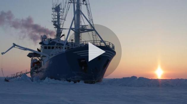
Extreme Research Shows How Arctic Ice is Dwindling. Rapid warming of the arctic is having a domino effect on weather and lower latitudes; here's an excerpt of a National Geographic update: "...Since
1979, when satellite records began, the Arctic has lost more than half
its volume of ice, which has diminished in both overall area and
thickness. The frozen area shrinks to its annual minimum in September,
at summer’s end. In September 2012 its extent was just half the average
during the 1980s and ’90s. The maximum ice extent in winter, usually
reached in March, also is declining, though at a slower rate; its
average thickness has decreased by half. What was once mostly a layer of
10- to 13-foot-thick ice floes that lingered for years—perennial
ice—has given way to large tracts of thinner, less reflective ice that
forms and melts during a single year. Sea-ice coverage has always
fluctuated naturally, but there’s little doubt among scientists that
man-made greenhouse gases are now accelerating its decline. “Old, thick
sea ice was a global reservoir for cold, but that is now changing,”
Overland says..."
How Climate Change Caused a Shift in Trends and Tech in 2015. Here's the intro to a story at virgin.com: "The
agreement was hard won, with country representatives working all night
over the summit’s last weekend to get the nuts and bolts firmly in
place. The deal means that countries promise to control the numbers of
carbon emissions. Simply put, these are the amounts by which countries
damage and pollute their atmosphere. Climate change has caused a change
in trends and technology. Right through 2015, we’ve seen a desire by
country leaders to work with entrepreneurs to help tackle the problem.
Entrepreneurs have been examining this through their companies; Bill
Gates, Mark Zuckerberg and Richard Branson have formed a group to invest in early stage clean energy companies..."


No comments:
Post a Comment