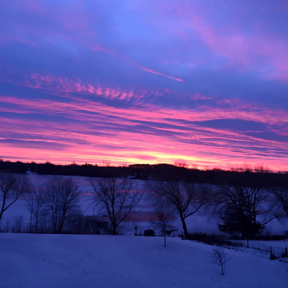
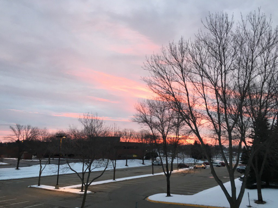
Thanks to Rob Koch from Scandia and @DKayserWX from Eden Prairie for the beautiful pictures below from Friday morning's sunrise!!
Mild and Somewhat Slushy This Weekend
By Todd Nelson, Filling in for Douglas
We're nearly through the first full month of 2016 and we're off to a mild and somewhat snow less start. Despite spending 9 nights below zero, the average January temperature is running a little bit above average. Overall, our meteorological winter is running quite a bit above average, which has had a hand in helping to produce a seasonal snowfall deficit of nearly 15 inches in Minneapolis.
Weather conditions will remain somewhat active over the next several days as waves of moisture scoot through the Midwest. However, highs in the 30s to 40 degrees will have wintry mixed precipitation in place this weekend. There is a chance that if enough cold air sneaks in on Sunday, a couple to a few inches of slushy snow could develop.
Our attention then turns to a much larger storm system brewing by Tuesday of next week; Ground Hog Day. At this point, it appears the heaviest snow will be found from the Central Plains to the Great Lakes, just south of us, but it'll be close.
Keep the shovels handy, winter isn't over yet.
________________________
Extended Forecast
FRIDAY NIGHT: Slushy mix, major roads mainly wet - icy secondary roads. Winds: SSW 10. Low: 29
SATURDAY: Mostly cloudy. Winds: SW 5-10. High: 39
SATURDAY NIGHT: Wintry mix with light snow accumulations. Winds: WNW 5-10. Low: 31.
SUNDAY: Ligh snow. A couple to few inches of slush possible. Winds: NW 7-12. High: 34
MONDAY: Lingering AM flakes, peeks of PM sun. Wake-up: 23. High: 29
TUESDAY: Breezy. Areas of snow Winds: NE 15-25. Wake-up: 19. High: 23
WEDNESDAY: Snow tapers to flurries. Slow AM Rush? Colder. Winds: NW 10-20. Wake-up: 11. High: 17
THURSDAY: Feels like January again. A few flakes. Wake-up: 4. High: 16
FRIDAY: Still chilly. Clouds fade. Wake-up: 4. High: 16.
_________________________________
This Day in Weather History
January 30th
1994: Duluth has a record low of -35.
________________________
Average High/Low for Minneapolis
January 30th
Average High: 25F (Record: 48F set in 1989)
Average Low: 8F (Record: -30F set in 1887)
________________________
Sunrise/Sunset Times for Minneapolis
January 30th
Sunrise: 7:36am
Sunset: 5:18pm
*Daylight Gained Since Yesterday: ~2mins & 29secs
*Daylight Gained Since Winter Solstice: ~56mins
_______________________
Moon Phase for January 30th at Midnight
0.9 Days Before Last Quarter

________________________
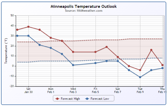
Minneapolis Temperature Trend
Mild temperatures look to continue through the weekend, but a larger storm system will move through the middle part of the country early/mid week next week and help to pull down another fresh batch of chilly Canadian air. This will help to drag temperatures down to the below average range once again, reminding you that it is still winter! The extended forecast suggests below average temperatures potentially continuing into the 2nd week of February.
________________________
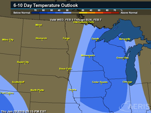
6 to 10 Day Temperature Outlook
According
to NOAA's CPC, the 6 to 10 day temperature outlook suggests below
average temperatures possible across parts of the Great Lakes and
Midwest through the first week of February.
Saturday Weather Outlook
Despite seeing areas of clouds and lingering wintry mixed precipitation early, temperatures will be quite mild. Highs will be in the 30s and 40s across the state, which will be nearly 10F to 15F above average!
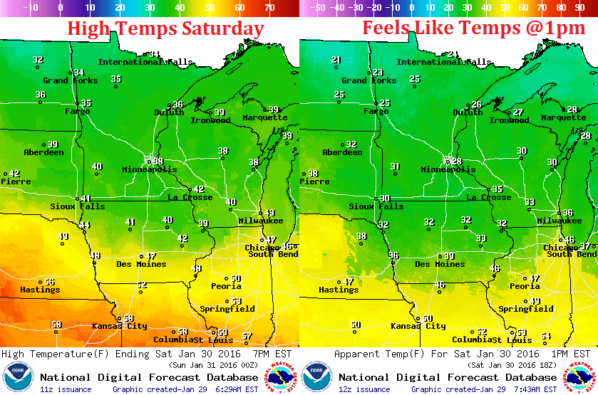
Saturday Weather Outlook
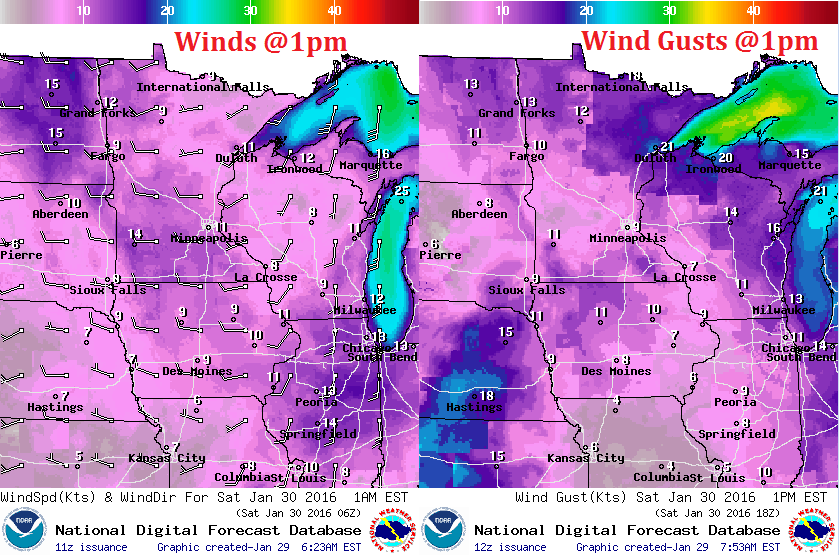
Winds won't be too big of an issue on Saturday. Generally out of the west at around 5-10mph.
Saturday Weather Outlook
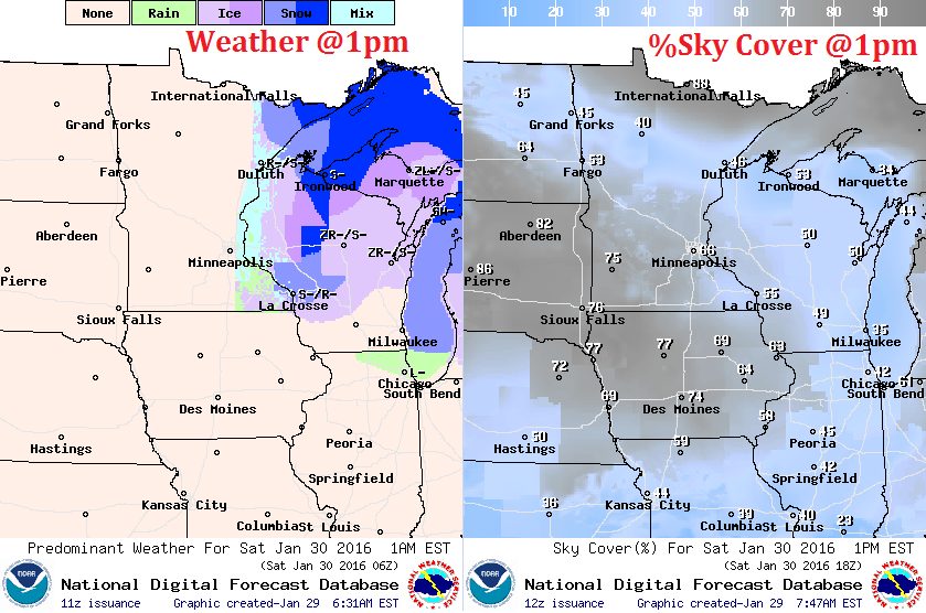
The clipper system that brought wintry mixed precipitation to the region PM Friday will still be in place over parts of Wisconsin on Saturday with continued wintry mixed precipitation. Most of us will stay precipitation free again until late Saturday night as another storm system moves in from the Dakotas. This one will bring another batch of rain, sleet and snow, but it will also bring a better chance of slushy snow accumulations to parts of the region through Sunday.
________________________________
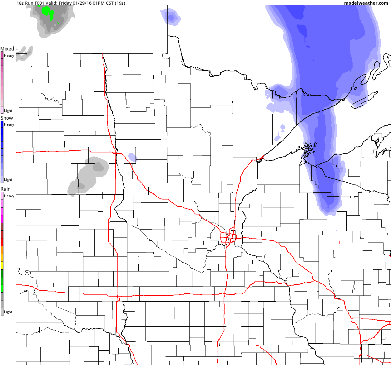
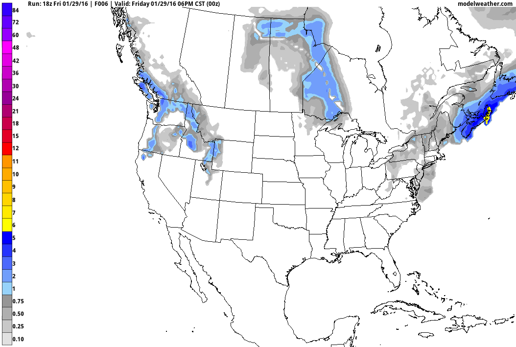
Simulated Radar
The simulated radar shows our first clipper from PM Friday and early AM Saturday moving quickly east of the region through the early weekend, while another system moves in PM Saturday - Sunday. This next system will bring a better chance of slushy snow accumulations to parts of the region, including the Twin Cities.
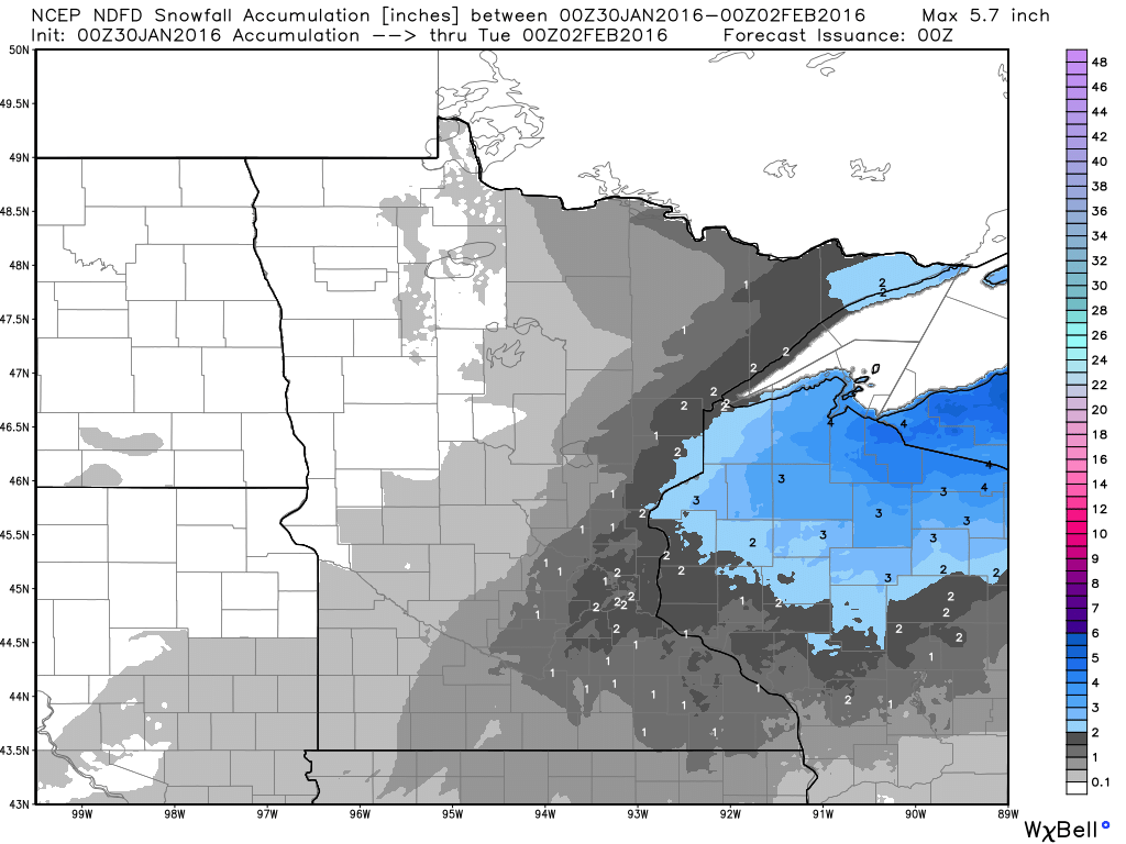
Minnesota Snowfall Potential
Here's the snowfall potential through 6pm Monday. Note that there appears to be some minor/slushy accumulations near the Twin Cities, but the heaviest looks to be found across northern Wisconsin and into the U.P. of Michigan.
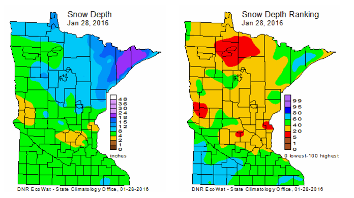
Minnesota Snow Depth January 28th
According to the Minnesota Climatology Working Group, the snow depth across the state on Thursday, January 28th was nearly 18"+ across the Arrowhead! This is good news for the Beargrease Sled Dog Marathon, which starts Sunday, January 31st in Two Harbors!
See more about the Beargrease Sled Dog Marathon HERE:
________________________
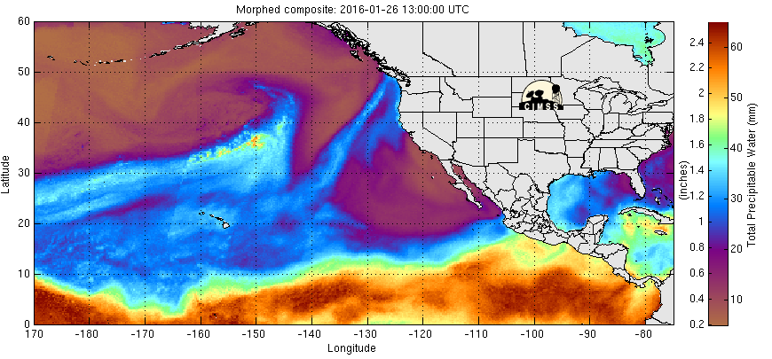
Pacific Precipitable Water Loop
Look at the deep plume of moisture in the Eastern Pacific that is surging into the West Coast. This will help to produce fairly significant moisture across the West Coast over the coming days. This will also help to produce a much larger storm system in the Central U.S. by the early/mid part of next week with heavy snow and severe weather chances.
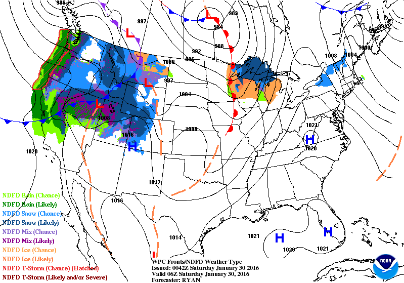
National Weather Outlook
Moisture in the Western U.S. will continue to spread southeast as a low pressure develops. The low pressure centered over the Four Corners Region by Sunday will be the same storm system responsible for heavy snow and severe weather next week.
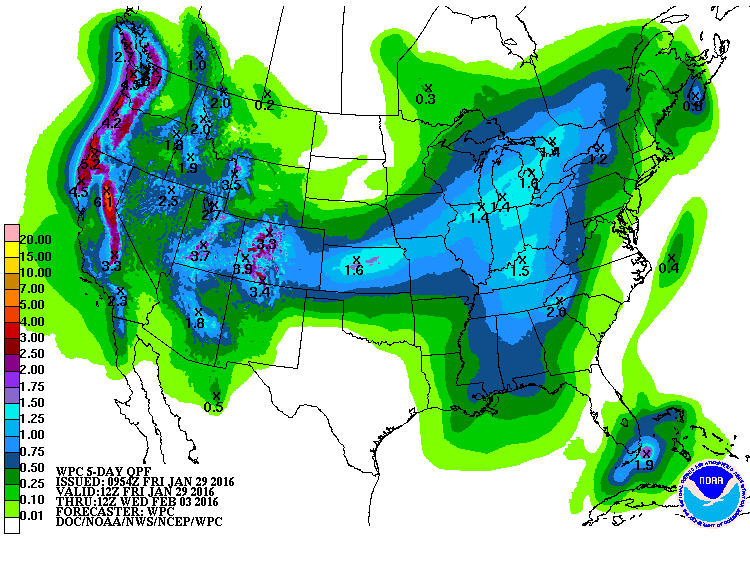
5 Day Precipitation Outlook
According to NOAA's WPC, the 5 day precipitation forecast suggests heavy moisture continuing in the Western U.S. with precipitation values approaching 3" to 6"+ in some spots. Note the heavier moisture moving through the Central U.S.. Some spots could see more than 1" as the storm system moves east!
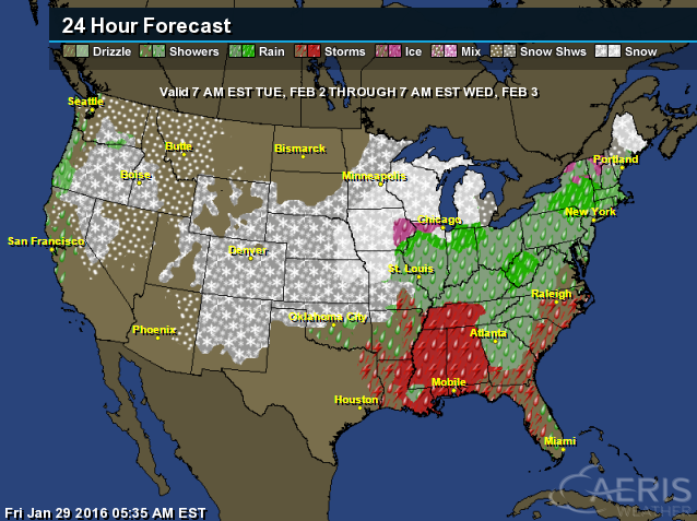
Snowfall Potential
The next storm system that will move through the middle part of the country through the early/middle part of next week will bring a swath of snow from the Central Plains to the Great Lakes.
__________________________________
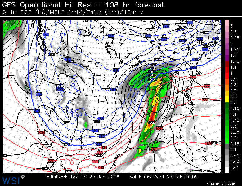
Ground Hog Day Storm
Here's the storm system expected to plow through the middle part of the country on Tuesday, February 2nd; Ground Hog Day. Temperatures on the northern side of the system will be cold enough for snow, while weather conditions on the south side of the storm will be unstable enough for strong to severe storms in the South-central U.S.
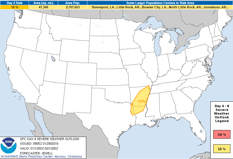
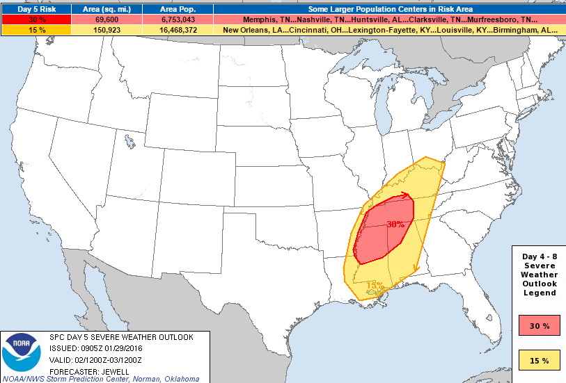
Upcoming Severe Threat Next Week
...DISCUSSION... MODELS ARE IN GOOD AGREEMENT FOR THE D4-D6 PERIOD INDICATING A THREAT OF SEVERE WEATHER PERHAPS BEGINNING AS EARLY AS LATE MON NIGHT INTO EARLY TUE MORNING ACROSS PORTIONS OF AR...NRN LA AND NERN TX...WITH A MORE SUBSTANTIAL THREAT EXPANDING ACROSS THE CNTRL GULF COAST STATES NWD TO THE OH VALLEY.
ON MON/D4...LOW PRESSURE IS FORECAST TO DEEPEN ACROSS THE SRN PLAINS AS A STRONG UPPER JET INTENSIFIES ACROSS OK AND TX. LOW LEVEL MOISTURE WILL BE RAPIDLY INCREASING AS SLY WINDS STRENGTHEN...BUT INSTABILITY IS NOT EXPECTED TO FAVOR SEVERE STORMS UNTIL LATE IN THE D4 PERIOD WHEN 60-65 F DEWPOINTS WILL PRECEDE THE COLD FRONT FROM ARKANSAS SWD. STORMS SHOULD FORM IN THE 06-12Z TIME FRAME WITH A FEW SUPERCELLS OR SMALL BOWS CAPABLE OF DAMAGING WINDS OR BRIEF TORNADOES.
THE SYSTEM WILL CONTINUE TO MATURE WITH AN INCREASING SEVERE THREAT TO THE E ON TUE/D5...WITH BOTH MOISTURE AND INSTABILITY INCREASING THROUGHOUT THE DAY. THE BEST OVERLAP OF INSTABILITY AND ASCENT WOULD APPEAR TO BE FROM CNTRL AND NRN MS INTO NRN AL...WRN AND MIDDLE TN DURING THE DAY...OR JUST E OF THE MS RIVER. DESPITE THE WEAK INSTABILITY...EXTREME SHEAR PROFILES WILL FAVOR A FEW TORNADOES...POSSIBLY ONE OR TWO STRONG...ALONG WITH DAMAGING BOWING STRUCTURES. SOME SEVERE THREAT IS LIKELY TO PERSIST AFTER 00Z ACROSS AL...THE FL PANHANDLE...NWRN GA AND PERHAPS ERN TN/KY...BUT CONDITIONS WILL NOT BE OPTIMAL WITH THE LOW CONTINUING TO LIFT NWD...LEAVING THE INSTABILITY BEHIND TO THE S.
Severe Threat Monday
Severe Threat Tuesday
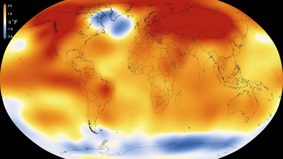
"NASA, NOAA Analyses Reveal Record-Shattering Global Warm Temperatures in 2015"
"Earth’s 2015 surface temperatures were the warmest since modern record keeping began in 1880, according to independent analyses by NASA and the National Oceanic and Atmospheric Administration (NOAA). Globally-averaged temperatures in 2015 shattered the previous mark set in 2014 by 0.23 degrees Fahrenheit (0.13 Celsius). Only once before, in 1998, has the new record been greater than the old record by this much."
See the full story from NOAA HERE:
______________________________
"Human impact has pushed Earth into the Anthropocene, scientists say"
"There is now compelling evidence to show that humanity’s impact on the Earth’s atmosphere, oceans and wildlife has pushed the world into a new geological epoch, according to a group of scientists. The question of whether humans’ combined environmental impact has tipped the planet into an “Anthropocene” – ending the current Holocene which began around 12,000 years ago – will be put to the geological body that formally approves such time divisions later this year. The new study provides one of the strongest cases yet that from the amount of concrete mankind uses in building to the amount of plastic rubbish dumped in the oceans, Earth has entered a new geological epoch."
See more from TheGaurdian.com HERE:

"Tall Ships Return to Duluth in August, with the World's Largest Rubber Duck in Tow"
"As if a dozen or so tall-masted ships arriving in Duluth would not generate enough buzz, the organizers of Tall Ships Duluth 2016 have signed up another iconic maritime figure for the summer festival. The “World’s Largest Rubber Duck” will be joining the galleons and schooners at the August 18-21 event. The giant ducky appeared in 2014 during the Los Angeles Tall Ships Festival and was photographed by Mayor Eric Garcetti (who let us use his photo). The 61-foot-tall inflatable duck has drawn crowds around the world in Europe, Asia and beyond. L.A. got 277,000 people for its five-day festival. The last Tall Ships Duluth (without the duck) attracted up to 250,000. We may have a record year coming!"
See the full story at LakeSuperior.com HERE:
(Photo courtesy: Eric Garcetti)

_______________________________
Thanks for checking in and have a great weekend Ahead! Don't forget to follow me on Twitter @TNelsonWX

No comments:
Post a Comment