Mild Bias Into Next Week - Negative AO Hints at Real Cold Front mid-January
28 F. high temperature at KSTC Friday. 21 F. average high on January 1. 30 F. high on January 1, 2015.
January 2, 1941:
Grand Portage gets over 4.5 inches of precipitation in 24 hours. That's
roughly how much normally falls there during the 'winter' months from
November to February.
Meandering Arctic Oscillation: Colder mid-January
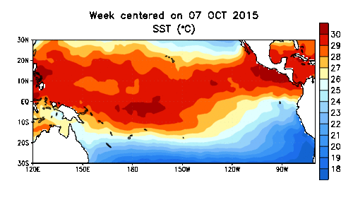
Much
of the unusual warmth showing up over North America can be tied to the
strongest El Nino since 1998; the equivalent of baking garlic into your
apple pie. It flavors everything.
Record heat and El
Nino-strengthened winds triggered the deadliest December for tornadoes
in U.S. history; a warmer, wetter atmosphere spawning flooding on the
Mississippi River not seen since 1993.
Another factor
meteorologists track is the AO, the Arctic Oscillation, a measure of the
intensity and configuration of the polar vortex swirling above the
arctic. Unusually low pressure has kept bitter air bottled up at
northern latitudes, but the pattern is shifting; warmer high pressure
over the North Pole is about to shove this cold dome southward.
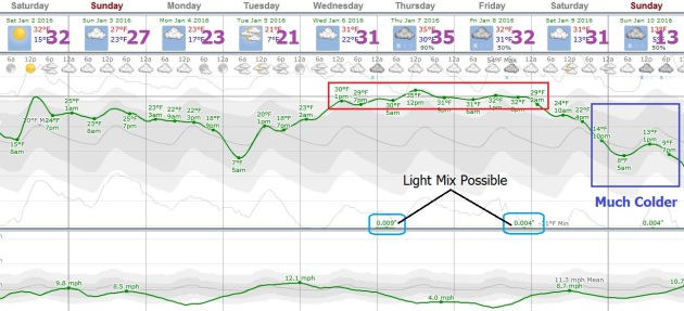
ECMWF guidance pulls a shot of subzero air into Minnesota one week from Monday; the first real Siberian jolt of the winter season. A little snow may fall next Friday
but no forbidding storms are brewing. We nudge 30F today, maybe 3 or 4
days near freezing next week before the freezer door swings wide open.
It wouldn't be winter without a subzero smack!
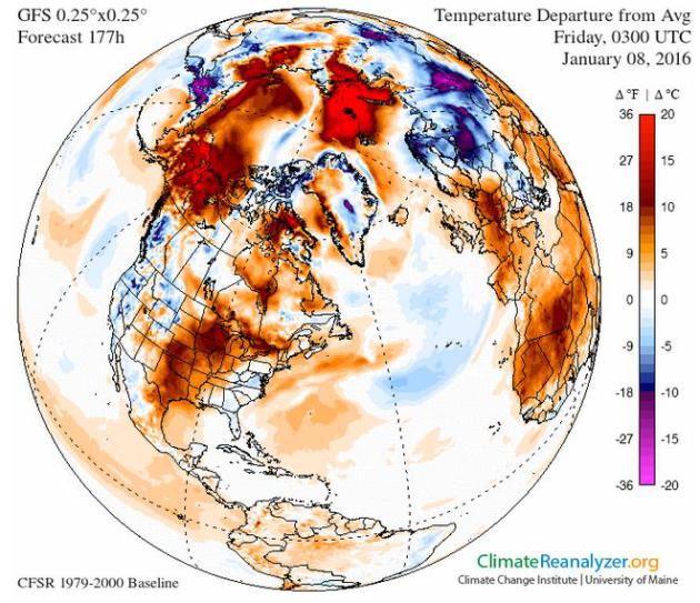
* 250 mb jet stream winds valid 03z, January 8, courtesy of Climate Reanalyzer.
Change in the Weather?
The Arctic Oscillation has been positive much of autumn 2015, meaning a
tight polar vortex with few southern intrusions of bitter air, but NOAA
models suggest a shift to a negative phase is underway, which means a
good chance of a few (polar) outbreaks within 1-2 weeks. That said, the
volume, intensity and duration of polar air this winter probably won't
be as severe as recent winters as a warm El Nino signal continues to
overwhelm the pattern across North America.
In Search of Bitter Air.
We'll see a couple of (real) cold frontal passages in mid-January, but
truly frigid air is in short supply across the Northern Hemisphere for
the next few weeks. We're closing in on the point where "average" feels
like a cold front. It's the rough equivalent of opening up the cold
water spigot and only a trickle comes out.
Above Average Into Next Week.
European model guidance shows temperatures averaging about 10F. above
average, nighttime lows some 15-20F warmer than normal into Saturday of
next week, followed by a sharp cold frontal passage a week from
tomorrow. A little snow or a light mix is possible Thursday and Friday.
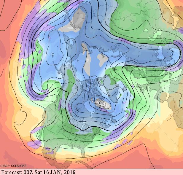
Couple of Cold Swipes.
Although no sustained polar air is brewing, at least not yet, the
forecast for January 15 at 500 mb (GFS model) suggests colder than
average weather for the northern tier states with a few nights below
zero mid-month. Hardly surprising or unusual, considering the coldest
weather of the entire year usually takes place in mid-January.
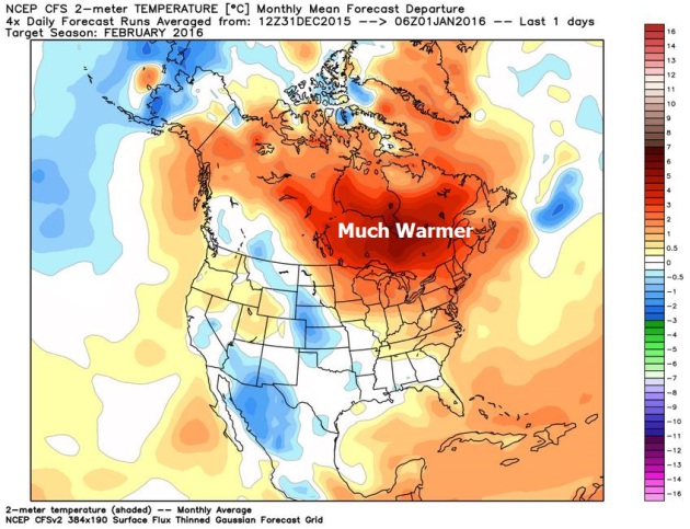
Mild Signal Lingers Into February?
Here is NOAA's CFS climate model guidance for the month of February,
showing temperatures 3-5F warmer than average across Minnesota next
month, even warmer across much of Canada. Source: WeatherBell.
Why We'll Keep Having Weird Weather in 2016.
Additional warmth is loading the dice, spiking the punch in favor of
more extreme events. They would have happened anyway, but a warmer
climate is "juicing" the atmosphere, making droughts and floods deeper,
longer and stronger. Here's an excerpt from TIME: "...In
recent years, a weak Arctic Oscillation has allowed cold air to escape
the Arctic, leading to a chilly winter in the Northeast U.S. But the
Oscillation appears to be holding strong, according to NOAA data,
lessening the chance of a chilly winter. Climate phenomena like El Niño
are not new occurrences, but scientists say that global warming has
contributed to making them larger and more damaging. NOAA’s Deke Ardnt
likens climate change to a flight of stairs. “Over time you get higher
and higher,” Ardnt told The Guardian.
“El Niño is like standing on your tippy toes when you’re on one of
those stairs. Both of those together work to create the warmest
temperature on record...”
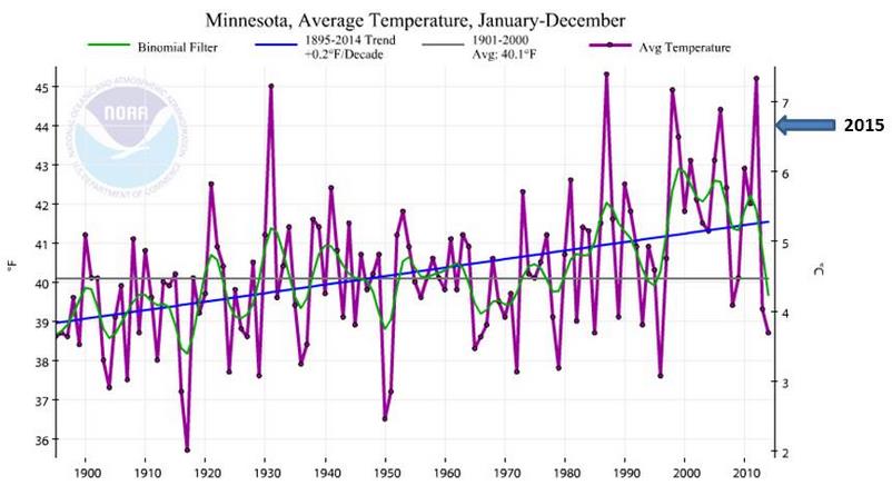
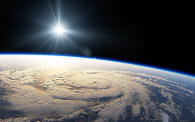
Total Precipitable Water animation above courtesy of NOAA NESDIS. December: Warmest, Second-Wettest Ever Recorded for Minnesota. Here's an excerpt from Dr. Mark Seeley's latest installment of Minnesota WeatherTalk: "For
the 4th consecutive month Minnesota recorded warmer than normal
temperatures. Observers reported mean monthly temperatures for December
that were from 8 to 12 degrees F above normal, marking the warmest
December in history on a statewide basis, surpassing the previous record
from December 1939. Extremes for the month ranged from 53F at Marshall
on the 9th to -11F at Thief River Falls on the 28th. On a statewide
basis December of 2015 was the 2nd wettest in history, with an average
value of nearly 1.90 inches. Some observers reported their wettest
December in history, including: 4.09" at Two Harbors; 4.90" at
Caledonia; 5.38" at La Crescent; 4.28" at Preston; and 4.00 inches at
Spring Grove..."
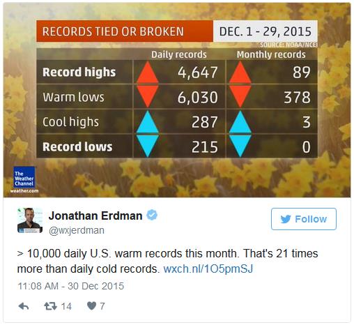
Two Charts Show December's Crazy Warmth. Climate Central takes a look at historic warmth in December: "...The month is likely to be the hottest December on record for most, if not all, states to the east of the Mississippi, capping off a year that is virtually a lock to be the world’s hottest on record.
As the first chart, from the Weather Channel, shows, there were about
10,000 combined daily record highs and record warm lows compared to just
around 500 record cold highs and lows this month — a ratio of about
21-1. The higher ratio of record highs to lows
is a hallmark of global warming, which skews the odds in favor of the
former. Without warming, the ratio would be about 1-to-1, at least on
the scale of years or decades. But over the past two decades, those
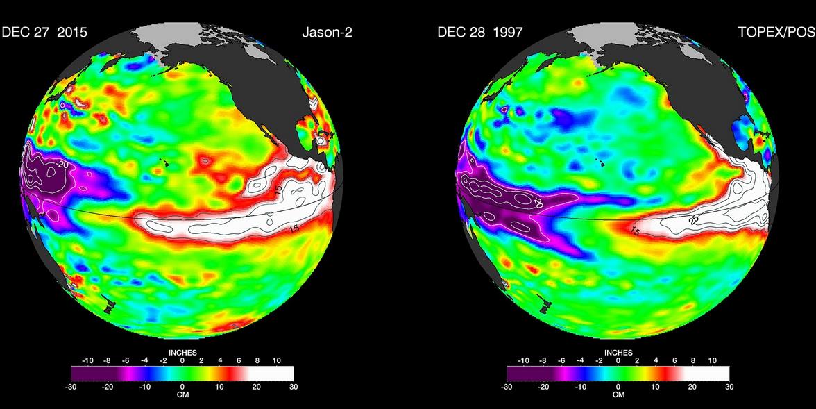
figures have tilted 2-to-1 in favor of record heat..." El Nino: Why Predictable Climate Event Still Has The Scientists Guessing. Every El Nino is different, it turns out, and this one already rivals 1997-98. Here's an excerpt from The Guardian: "...The
last great El Niño, in 1997-98, helped make 1998 the then warmest year
on record – that too was accompanied by a series of devastating events
around the world, among them ice storms in North America, floods on the
west coasts of the Americas and forest fires in Borneo. It also delayed
the monsoon rains in India, warmed tropical waters so severely that
coral reefs started to “bleach” and die, and signalled a record-breaking
season of typhoons and tropical cyclones in the eastern Pacific.
Although researchers are fairly sure that climate change as a
consequence of the combustion of fossil fuels, and the release of
greenhouse gases, could make El Niño more frequent, or more devastating,
or both, it remains a natural, cyclic event..."
Graphic credit above: "False-color
images provided by Nasa compare Pacific Ocean water temperatures from
the El Niño in 1997 (right) and the current El Niño." Photograph: AP.
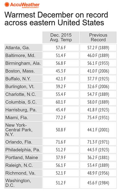
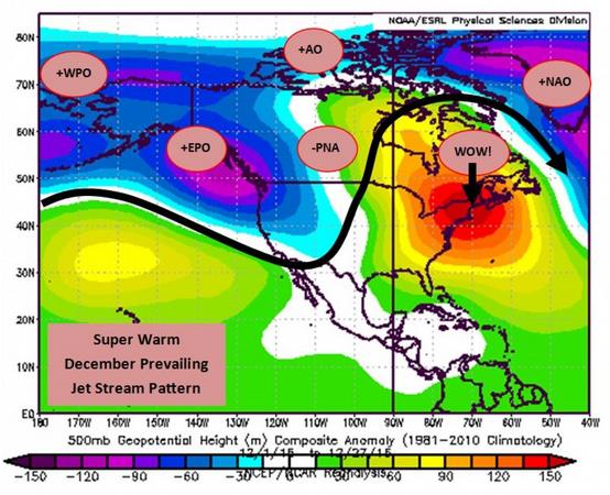
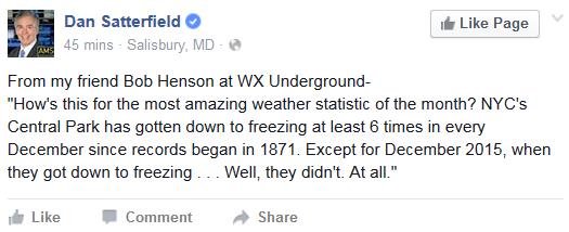
Record Warmth in December. It was the warmest December ever recorded for Washington D.C., Philadelphia, New York City and Boston, according to AccuWeather.
Washington D.C. Eclipses Warmest December on Record by Enormous Margin. Here's an excerpt of a timely explainer from Capital Weather Gang that delves into some of the reasons (beyond El Nino), including the AO and NAO: "...A
combination of the strongest El Niño on record (by some measures) and a
few other factors drove the super-warm pattern over eastern North
America. The prevailing jet stream featured an incredible, warm ridge of
high pressure over the entire eastern half of the continent — a
complete reversal from last year’s winter pattern.All of these
large-scale patterns worked together to create impressive warmth in the
Eastern United States.
+WPO Positive Western Pacific Oscillation (warm Eastern U.S. signal) +EPO Positive Eastern Pacific Oscillation (warm Eastern U.S. signal) -PNA Negative Pacific-North American (warm Eastern U.S. signal) +AO Positive Arctic Oscillation (normally a warm Eastern U.S. signal) +NAO Positive North Atlantic Oscillation (normally a warm Eastern U.S. signal)
The resulting surface temperature anomaly was astonishing..."
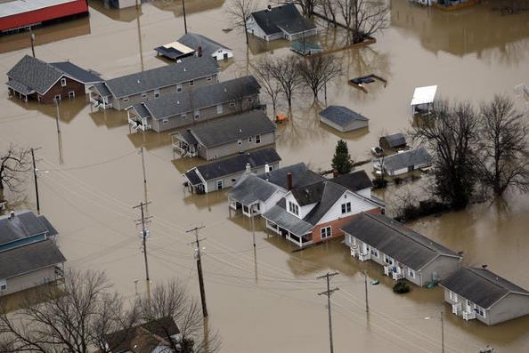
Flood-Ravaged St. Louis Begins Cleanup as Floods Break and Threaten Levees Elsewhere. The Mississippi River is out of it's banks, in some cases exceeding levels last reached in 1993. Here's an excerpt from The Portland Press Herald: "The
worst of the dangerous, deadly winter flood is over in the St. Louis
area, leaving residents of several water-logged communities to spend the
first day of 2016 assessing damage, cleaning up and figuring out how to
bounce back – or in some cases, where to live. Farther south, things
were getting worse: Record and near-record crest predictions of the
Mississippi River and levee breaks threatened homes in rural southern
Missouri and Illinois. Two more levees succumbed Friday, bringing to at
least 11 the number of levee failures..." (Latest flood crest forecast available from NOAA). In Midwest, 1,000 Flood-Fighters Work To Hold Back New Year's Floods. CSMonitor.com has an update on Mississippi River flooding now rivaling 1993's epic flood. Here's an excerpt: "With
the Mississippi River and four other major US rivers building toward
historic crests for a winter flood, some 1,000 US flood fighters have
spread out across America's mighty river valleys to once again test the
wherewithal of the world's grandest plumbing works: the Mississippi
River and Tributaries project. El Niño conditions in the Pacific have
created an unusually wet and warm mess across the nation's midsection
and into the Deep South. The gauge at St. Louis is clawing up toward 42
feet, its third-highest in recorded history. Parts of St. Louis are
already underwater as the confluence of the Missouri River and the
Mississippi roil the city's shipping front and close the St. Louis
harbor. The waters are expected to crest in Missouri on New Year’s Day..."
Photo credit above: "Homes
are surrounded by floodwater in Pacific, Mo., Wednesday. A rare winter
flood threatened nearly two dozen federal levees in Missouri and
Illinois on Wednesday as rivers rose, prompting evacuations in several
places." Jeff Roberson/AP.
CNN has more details on the potentially historic flooding around St. Louis here.
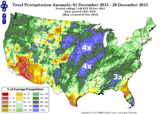
More April than December.
Check out the precipitation anomaly map for December 1-29, showing 4
times more rain than average across a huge swath of territory from
Wisconsin into central Iowa and eastern Nebraska; another soggy
bulls-eye from Tulsa to St. Louis. It's unusual to see such a large area
over the USA east of the Rockies so wet in December; a function of El
Nino and a warmer atmosphere able to hold more water vapor. Source:
PRISM Climate Group, Oregon State University.
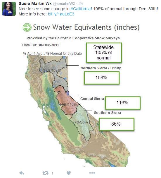
El Nino's Silver Lining.
The firehose of moisture from El Nino has been trained on the Pacific
Northwest, but there are signs the storm track will shift southward in
the coming weeks, putting California in the potential cross-hairs of
flooding rains and mudslides. December precipitation (rain and snow) was
higher than average across most of the state, still in the grips of
extreme drought.
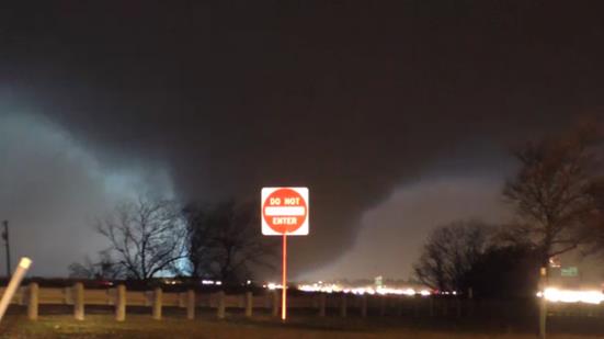
Pick of the Week: Massive Tornadoes Roar Across Texas. Typical for April, a bit unusual for late December, according to The Capital Weather Gang: "... The
storms left 11 people dead, and incredible destruction in their wake.
It was the second day of destructive tornadoes in less than a week,
following an outbreak on Dec. 23 that killed 10 people. Just like that,
in the span of four days, 2015 went from having a record low number of
tornado fatalities to tripling the annual count. In fact, between the
two tornado events, the month brought more tornado deaths than all the
other months of the year combined, making it the deadliest December on
record..."
Image credit above: "Lightning illuminates a violent tornado as it roars across the landscape between Garland and Rowlett, Texas, on Dec. 26." (Nathan Moore/Stormviewlive)
Video: Man Records Tornado's Approach, Aftermath. KLTV
in Tyler Texas has a link to some remarkable footage taken as a massive
tornado tore through the east suburbs of Dallas; here's an excerpt: "A
series of heartbreaking videos from a man who recorded a tornado in the
Dallas-area is gaining shares on Facebook. The videos were posted by
Randy Pritchard. Recording from what appears to be a cellphone,
Pritchard captured video of the tornado as it made its way across a lake
and toward the neighborhood. He was standing outside with friends when
the storm struck and caught images of lightning strikes and the massive
funnel cloud. The group rushes to the neighbor’s house as the storm
nears and gathers in his shelter..." (Rated PG for rough language).
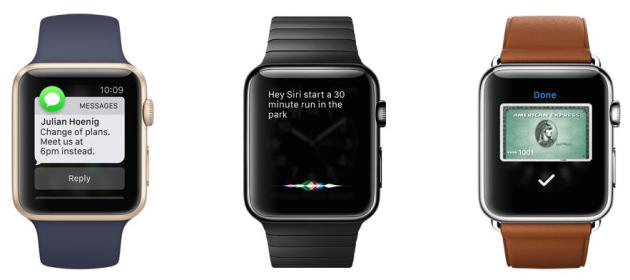
With Taps on the Wrist, Apple Watch Points to the Future. Just another gadget, or something more profound? This tech writer at The New York Times is pretty sold; here's an excerpt: "...And
yet, after almost eight months, the Apple Watch feels like the future
to me. More than anything else, the watch has changed the way I
communicate via email and text messages. Using Apple’s VIP feature, I
direct all of the most important messages to my watch, which alerts me
with a subtle tap on my wrist or a soft ding. I ignore most after a
quick glance. (Sorry, Mom.) Many get a quick “O.K.” or “Sounds good.” I
pull out my phone only for the ones I need to respond to at length. The
same is true for phone calls, which appear on my watch while my phone
remains tucked away in my pocket, or still at my desk on the other side
of the office. It’s like Caller ID for my wrist..."
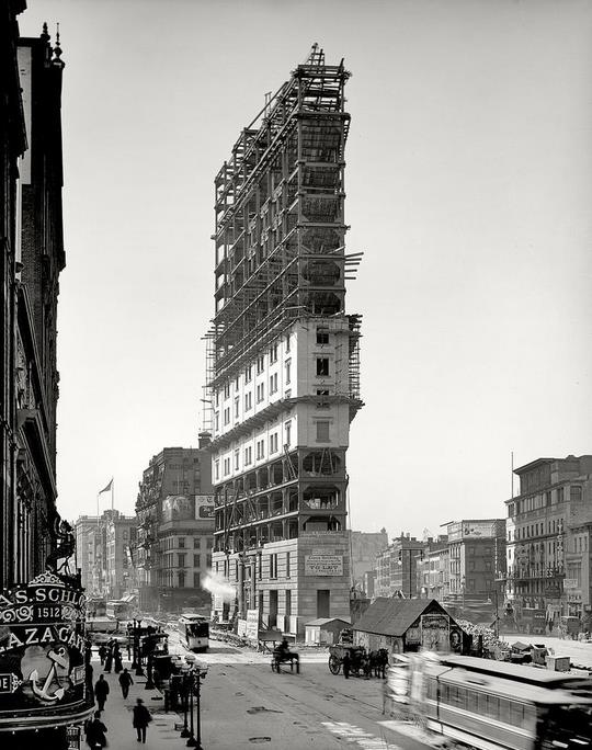
How New Year's Eve Came to Times Square. Atlas Obscura has an interesting story about the origins of the tradition; here's the intro: "On
New Year’s Eve in 1903, there was no countdown to midnight, no ball
drop, and no partygoers wearing silly hats in Times Square. In fact,
there was no “Times Square.” But all that changed the following year,
when the newspaper publisher Adolph Ochs moved the headquarters of
the New York Times from Park Row to West 42nd Street and celebrated with
a bash that launched an iconic New Year tradition..."
Photo credit above: "One Times Square under construction in 1903." (Photo: Public Domain/WikiCommons).
TODAY: Partly sunny, milder. Winds: W 10-15. High: near 30
SATURDAY NIGHT: Partly cloudy. Low: 15
SUNDAY: Blue sky, seasonably chilly. Winds: NW 8-13. High: 25
WEDNESDAY: More clouds, trending milder. Wake-up: 18. High: 31
THURSDAY: Cloudy, few flurries possible. Wake-up: 27. High: 30
FRIDAY: Period of light snow. Wake-up: 28. High: 32
Climate Stories...
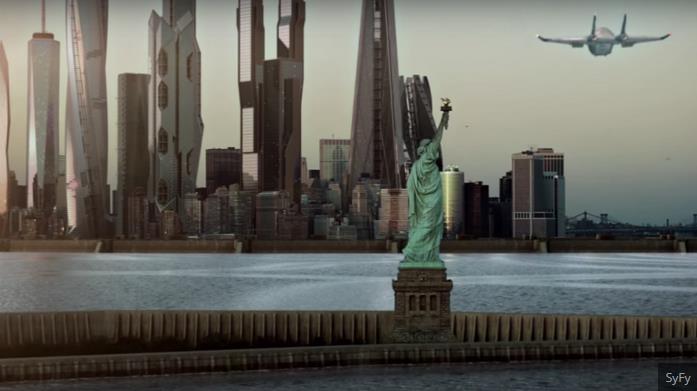
Climate Change is Showing up in Blockbusters and Binge Watches. So What? Grist has the article; here's the intro: "At
one point midway through the first episode, the camera pans past the
skyline of New York. It’s both familiar and uncanny: There’s One World
Trade Center, standing in a thicket of shinier, spindlier towers that
announce we are now in The Future. And standing sentinel outside the
city is the Statue of Liberty — except now she is ringed by a reinforced
seawall, set in ten feet of angry surf. That’s it. That’s all the
reference to climate change we get in the 45 minute-long pilot of The
Expanse, SyFy’s new space drama. In fact, only a handful of those
minutes are spent on Earth at all..."
“...What
is most unfortunate,” said Farrell, the Yale sociologist, “is that
polarization around climate change was manufactured by those whose
financial and political interests were most threatened.” Even today, he
added, that polarization has crippled any hopes for bipartisan policy
solutions.... "
Climate Chaos, Across the Map. Justin Gillis at The New York Times
tries to connect the dots between weather volatility, ENSO (El Nino)
and larger planetary trends. As always, trying to prove cause and effect
with the atmosphere is problematic, but are we inadvertently loading
the dice in favor of more extremes, especially with rainfall and heat?
Here's an excerpt: "...In both the Atlantic and Pacific, the
unusually warm ocean surface is throwing extra moisture into the air,
said Kevin Trenberth, a climate scientist at the National Center for
Atmospheric Research in Boulder, Colo. Storms over land can draw
moisture from as far as 2,000 miles away, he said, so the warm ocean is
likely influencing such events as the heavy rain in the Southeast, as
well as the record number of strong hurricanes and typhoons that
occurred this year in the Pacific basin, with devastating consequences
for island nations like Vanuatu. “The warmth means there is more fuel
for these weather systems to feed upon,” Dr. Trenberth said. “This is
the sort of thing we will see more as we go decades into the future.”
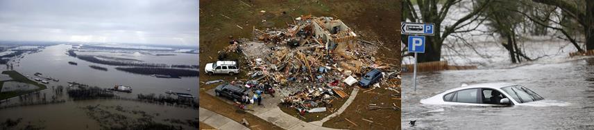
Photo montage credit,
left to right: Missouri flooding: AP Photo/Jeff Roberson; Dallas area
tornado: G.J. McCarthy/The Dallas Morning News via AP; Scotland
flooding: Danny Lawson/PA via AP.
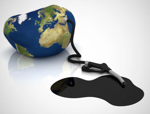
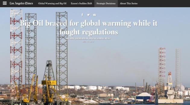
Big Oil Braced for Global Warming While It Fought Regulations.
Because a little organized, manufactured misinformation can be good for
the bottom line, at least in the short-term. But truth usually catches
up with you, and now the question is what the fossil fuel industry knew,
when they knew it, and how they communicated inherent climate risk to
the general public vs. internal, strategic purposes. The Los Angeles Times continues their reporting; here's a snippet of the most recent article: "A
few weeks before seminal climate change talks in Kyoto back in 1997,
Mobil Oil took out a bluntly worded advertisement in the New York Times
and Washington Post. “Let’s face it: The science of climate change is
too uncertain to mandate a plan of action that could plunge economies
into turmoil,” the ad said. “Scientists cannot predict with certainty if
temperatures will increase, by how much and where changes will occur.”
One year earlier, though, engineers at Mobil Oil were concerned enough
about climate change to design and build a collection of exploration and
production facilities along the Nova Scotia coast that made structural
allowances for rising temperatures and sea levels..."
Buss: GOP Should Rethink Climate Change. Here's an excerpt of an Op-Ed at The Detroit News: "...Meantime,
unless Republicans find a way to talk about climate change that doesn’t
make them sound out of touch, GOP presidential candidates will continue
to struggle to relate to the average voter on this issue. Almost every
poll shows younger voters believe some degree of climate change is
taking place, and that human activity significantly contributes to its
severity. A majority of all Americans believe that as well. That means
it’s an issue the Republican Party must get a handle on, particularly if
it wants to be the party of the future. Conservative candidates don’t
lead the conversation on climate change, largely because they don’t
believe there’s anything to discuss. Instead, progressives and their
Democratic candidates control the conversation and make everyone else
out to sound medieval..."


No comments:
Post a Comment