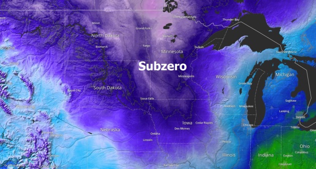
Minor League Cold Front by 1977 Standards - Mild Signal Returns late January, May Linger into Spring
11 F. high in St. Cloud Saturday (12:10 AM, temperatures were in single digits by afternoon). 21 F. average high on January 9. 4 F. high on January 9, 2015.
-43 F. record low at KSTC (January 9, 1977).
January 10, 1990: A January 'heat wave' forms. MSP Airport warms to 49 degrees. January 10, 1975:
The 'Blizzard of the Century' begins. Also called the 'Super Bowl
Blizzard,' it was one of the worst blizzards ever. The pressure hit a
low of 28.62. This was the record until 1998.
Character-Building Football Game Late January Thaw
The
best part of breaking your ankle is hearing about other people's old
injuries. The best part of a Minnesota cold wave is watching the
reaction on a visitor's face when you describe what subzero is like.
"It
feels like you're breathing in battery acid, more tickle than pain."
Don't stop there. "I remember a similar outbreak. Lost my left ear -
came right off. Doctor attached it backwards, now I can't tell if I'm
coming or going."
In the sun, stomping around a little, properly
dressed (no exposed skin - a rule I live by year-round) you should be
just fine at today's game. Earmuffs and boots are highly recommended -
if your feet stay warm you feel better, longer.
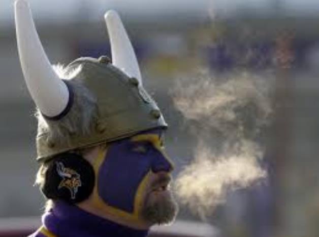
This should be one of the top two coldest home games for the Vikings franchise; one of the 10 coldest NFL games ever played.
An even colder swipe arrives Tuesday, with only a modest recovery during what should be the coldest week of winter. A burst of fluff is possible Monday - but this cold dome will steer big storms well south of Minnesota.
I still see a mellowing trend and thawing temperatures by late January.
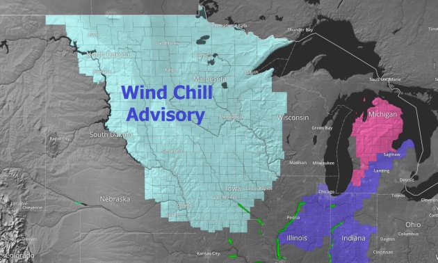
Wind Chill Advisory.
A numbing breeze will blow much of today, although wind speeds won't be
as high as models were suggesting a few days ago, generally in the
10-15 mph range. That will make for a morning wind chill ranging from
-20 to -25 in the metro, "mellowing" to -15F around kick-off at noon.
Source: AerisWeather.
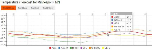
Models Agree: It's Cold.
The forecast temperature for noon today ranges from -4 to +1F, I
suspect it will be about -1F or -2F (give or take 10 degrees). Cold
enough to get your attention. Graph: Aeris Enterprise.
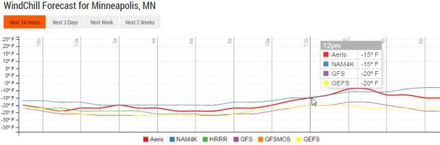
Predicted Wind Chill.
Models are in rare, tight alignment and agreement, showing midday wind
chills at TCF Stadium in the -15 to -20F range. The sun will help, at
least a little. This would be a typical January day in the 70s and early
80s. With recent warmth and generally milder winters overall we're not
as acclimated to these cold shots as our parents and grandparents were.
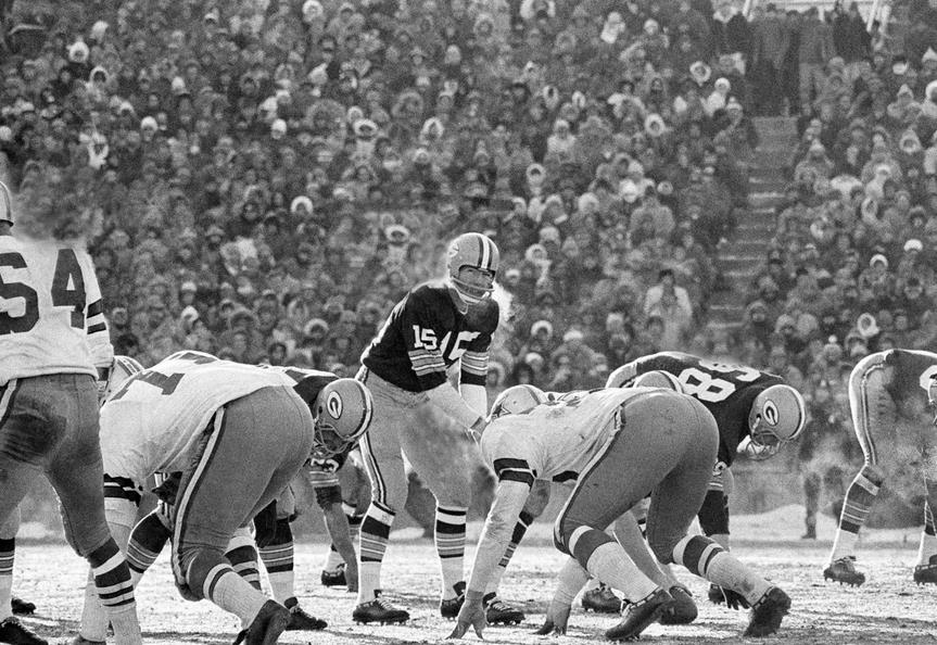
Sunday's Vikes-Seahawks Game: One of the 10 Coldest NFL Games on Record?
It'll be close, but if the air temperature stays below zero at kick-off
around noon it would probably qualify. More details from the NFL: "The forecast calls for frigid temperatures
for the Minnesota Vikings' home wild-card playoff game against the
Seattle Seahawks on Sunday. Only time will tell if Sunday's game joins
this illustrious list of icy showdowns." From another NFL article: "...Minnesota's
three coldest home games in franchise history were: Dec. 3, 1972 versus
Chicago at minus-2 degrees; Dec. 10, 1972 versus Green Bay at 0
degrees; Nov. 29, 1964 versus Los Angles at 5 degrees. The Vikings
'last home outdoor playoff game in Minnesota was Dec. 26, 1976 in the
NFC Championship. Fran Tarkenton led the Vikes to a 24-13 victory over
Pat Haden and the Los Angeles Rams. The temperature was 12 degrees that day..." (File photo: AP).
A Subzero Home Field Advantage?
Not so much, if you drill down into the data, but west coast teams seem
to fare worse. In bitter cold conditions the home team won about 50% of
the time, flip of a coin. Here's a clip from Mark Seeley at this week's
Minnesota WeatherTalk: "...In
many cases the temperatures during the game did not indicate how severe
the wind chill conditions were, ranging from the -20°F to -50s°F. In
these 10 cold games the home team managed to win only 5 times (50%), but
the west coast teams (Raiders and Chargers) managed only 1 win in 4
tries. We'll see what happens..." (Image: NPR).
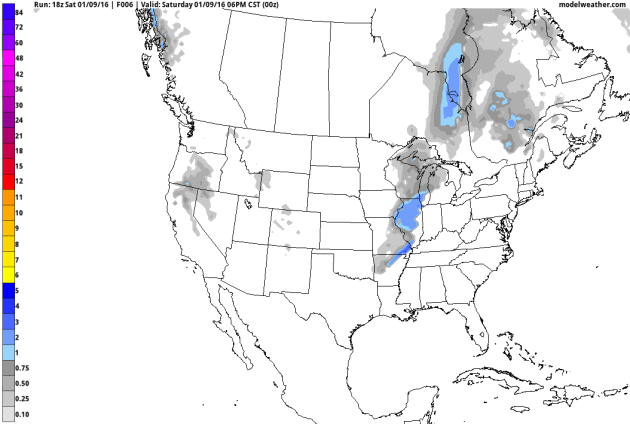
Nuisance Snow Monday?
Model guidance hints at a coating to an inch of fluffy, powdery snow
Monday, especially up north. Normally that wouldn't be a big deal, but
when it's this cold it doesn't take much snow to turn to the highways
into glaze ice; MnDOT's chemicals don't work very well below 15F or so.
Lake Effect Snows Kick In - Finally.
This would be typical for late November or December, but unusual warmth
has delayed snow season downwind of the Great Lakes. That will change
with this outbreak for the snow belts from Superior, WI to Cleveland and
Buffalo. Note that accumulating snow is predicted to fall as far south
as northern Alabama and Georgia. We want them to enjoy winter too,
right? GFS 10-day snowfall potential: NOAA and AerisWeather.
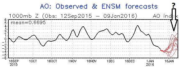
Coming Out of the Deep Freeze?
It's still early to reach conclusions, but the forecast AO (Arctic
Oscillation) suggests an upward trend after January 17 or so, which may
imply a milder, more zonal flow from the Pacific the last week of
January. Source: NOAA CPC.
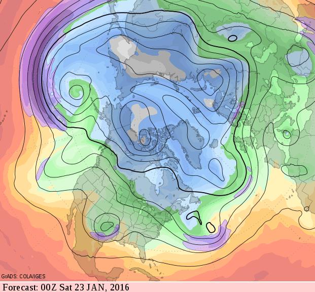
Mild Signal Returns by Late January.
I want to see a few more model runs for consistency, but the last few
GFS forecasts (looking out 2 weeks) suggests a fairly consisten
mellowing trend with prevailing jet stream winds high overhead blowing
from British Columbia by Friday evening, January 22. That should
translate into 20s, even a few 30s. Source: GrADS:COLA/IGES.
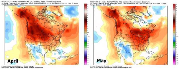
A Very Extended Outlook.
With El Nino not forecast to fade until late spring (in truth: it's
been stronger and more persistent than models have been predicting) it's
probably safe to say a mild signal will be with us into the summer,
possibly most of 2016. Mean, monthly temperature anomalies are forecast
to be as much as 15F. warmer than average over central Canada in
February, with a warm signal over the northern states. Above-average
temperatures (shaded in red) linger into May. Maps: NOAA CFSv2 guidance
courtesy of WeatherBell.
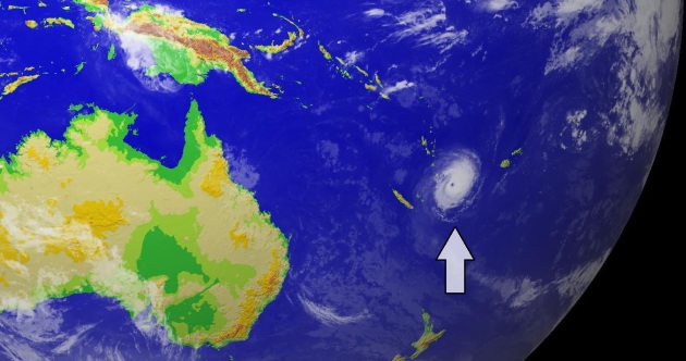
This Is What the Anthropocene Looks Like - Tropical Storms are Forming During Winter.
January tropical storms and cyclones are exceedingly rare, but the
frequency is increasing, due to unusual warmth in the oceans, especially
the Pacific. Here's an excerpt from RobertScribbler: "Since
climatology is the understanding of trends in average weather over long
periods, we can probably say that the off-season tropical cyclone
climatology has already changed for the Pacific. During
the 148 years since record keeping began in 1832 for the Pacific
through to 1980 only seven tropical cyclones were recorded to have
formed during the period of December through May. During just the 35
years since 1980, we’ve seen nearly twice that many — 12. In other
words, the rate of recorded off-season storm formation septupled or
increased a factor of 7. And both the earliest and the latest named
stormed have now formed during back-to-back years — Nine C on New Years
Eve less than two weeks ago and now Pali on January 7th. What we are
seeing now is unprecedented by any measure of tropical weather system
climatology. We have never seen a tropical storm form so early in the
Central Pacific at the same time during which a similar, very rare,
tropical system was threatening to form in the Atlantic..."
All The Winter's a Weird Weather Stage; Here Are The Players. The Associated Press reports on the myriad factors in play. El Nino gets most of the press, but there's more going on: "...We
have all of these large and unusual events happening all at the same
time and I don't think it has ever happened before," said Rutgers
University climate scientist Jennifer Francis. For a winter this
dramatic, it may help to consult the program: The star is El Nino, a
veteran of this stage for a few decades now. This natural warming of the
central tropical Pacific occurs every two to seven years or so, and
changes weather worldwide, especially in the Americas and Asia. It is
closely associated with heavy rain in California, and general warming.
It has less effect in Europe because that's further away. With its
flipside, La Nina, it is known as the El Nino Southern Oscillation, and
it lasts about a year..." (Animation: earth.nullschool.net).
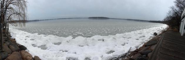
Winter's Slow Start Has Climate Scientists Guessing. Here's a clip from an MPR story that got my full attention: "...That's
been the story this season for Minnesota's winter sports enthusiasts.
In December, it rained in Duluth, and much of the state had little to no
snow cover. On average, Lake Minnetonka freezes over by Dec. 7; this
year, it didn't happen until New Year's weekend. Pete Boulay at the
State Climatology Office has been keeping track of ice-in and ice-out
dates. It's an inexact science, but he said at least a few lakes appear
to have either broken or come close to breaking records for their latest
ice-in this winter, including Green Lake northeast of Willmar..."
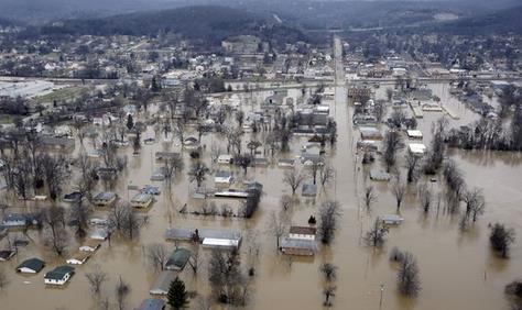
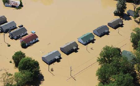
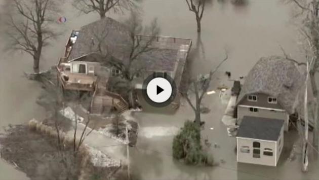
Central USA's Wintertime Floods Among Costliest in U.S. History.
Widespread flooding in late December and early January? The atmosphere
is confused, and so are meteorologists. Just now are the maps starting
to look like January again. Here's the intro to a USA TODAY story: "As
floodwaters continue to rise along the lower Mississippi River, it’s
clear the slow-motion disaster will be among the costliest wintertime
flood events in U.S. history. Officials are simply trying to tally the
price tag. The National Oceanic and Atmospheric Administration (NOAA)
said Thursday that damage from the floods will top $1 billion. That
number is likely to climb as the unpredictable and
overflowing Mississippi continues its march south..."
Photo credit above: "Floodwater
surrounds homes and businesses in Pacific, Mo. A rare winter flood
threatened nearly two dozen federal levees in Missouri and Illinois as
rivers rose, prompting many evacuations." (Photo: Jeff Roberson, AP)
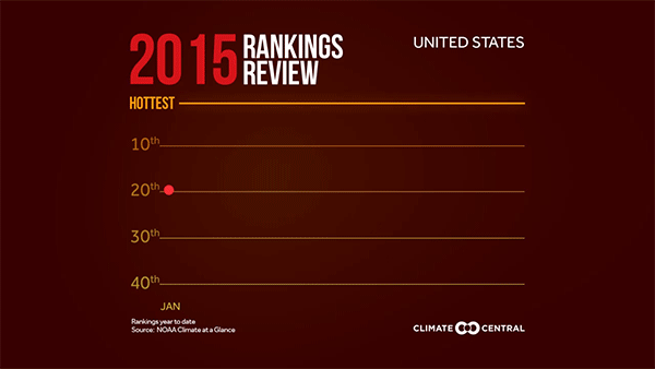
December Heat Boosts 2015 to Second Warmest Year for U.S. Climate Central has the details and some additional perspective: "...That second-place finish comes as both NOAA and NASA are expected to announce that the year was the hottest on record globally. While that record heat was helped in part by one of the strongest El Ninos on record, it was mainly due to
the contributions of manmade global warming, scientists have said. The
U.S. temperature ranking “is emblematic of what will ultimately be the
warmest year for the globe,” Deke Arndt, chief of NOAA Climate
Monitoring Branch, said during a press conference..."
2015: Second Warmest Year for USA on Record. According to NOAA NCDC there were 10 weather and climate-related disasters. Here's an excerpt: "The 2015 annual average U.S. temperature was 54.4°F, 2.4°F above the 20th century average, the second warmest year on record. Only 2012 was warmer for the U.S. with an average temperature of 55.3°F. This is the 19th consecutive year the annual average temperature exceeded the 20th
century average. The first part of the year was marked by extreme
warmth in the West and cold in the East, but by the end of 2015, record
warmth spanned the East with near-average temperatures across the West.
This temperature pattern resulted in every state having an above-average
annual temperature..."
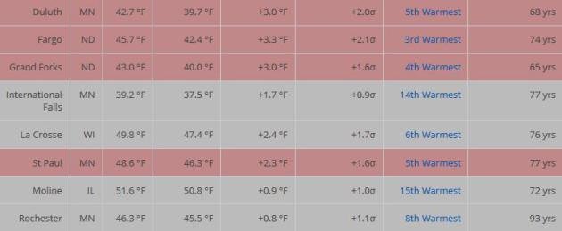
2015: 5th Warmest Year for Twin Cities. According to data from NOAA NCDC
it was the 5th warmest year for Duluth, the 3rd warmest for Fargo; the
8th warmest on record for Rochester. 180 long-term climate stations
around the USA are highlighted, for many cities it was the warmest year
in the historical record.
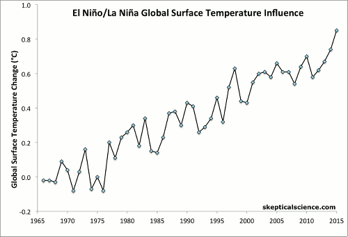
ENSO Temperature Trends.
Nature (nor science) ever moves in a perfectly straight line, but the
stair-step warming is evident on multiple data sets, minor
warming/cooling wobbles the result of El Nino and La Nina. Here's an
excerpt of a good explanation at Skeptical Science: "NOAA estimates
of the change in average annual global surface air temperature
(1966–2015) show that much of the short-term variability in the upward
temperature trend is produced by the El Niño/La Niña Southern Oscillation (ENSO),
a 2–7 year climate pattern in the tropical Pacific. Average air
temperature is affected by many different factors, including:
anthropogenic (human-caused) global warming (AGW) that is mainly caused
by CO2 emissions from burning fossil fuels; the 11-year solar sunspot cycle; sulfate aerosols from volcanic eruptions; and the periodic ENSO..."
The Importance of Being Prepared for a Natural Disaster.
Some of this makes sense, without even looking at the data. None of us
want to evacuate our homes (for any reason) and for older people the
challenge is even greater. There's very helpful information in this
article; here's a clip from The New York Times: "...Natural
disasters, which appear to be on the rise in part because of climate
change, are especially hard for older adults. They are particularly
vulnerable because many have chronic illnesses that are exacerbated
during the heat of a fire or high water of a flood. And many, of course,
are understandably reluctant to leave their homes, which hold so much
history. Studies show that over half the people who died in Katrina, the
hurricane that hit New Orleans and the surrounding Gulf Coast 10 years
ago, were 65 or older. Many were trapped in their homes; some died of
health complications caused by flooding..."
File photo credit: David Fine, FEMA.
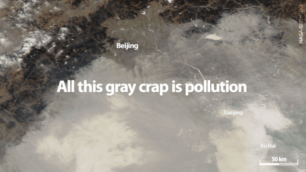
Humans Leave a Telltale Residue on Earth. Scientific American has more detail on what, exactly, makes for a new epoch; here's an excerpt: "...The present geologic epoch is known as the Holocene,
or "entirely recent," stretching back 11,700 years before 1950 to when
the last ice age began to melt and raised sea levels by roughly 120
meters over a few millennia. During that transition, carbon dioxide
levels in the atmosphere increased by roughly one part per million per
century. More recently, however, CO2 levels have been increasing
by two ppm per year, and rather than slowly returning to an ice age the
world has become ever warmer, melting more ice. The rapid increase in
excess CO2 comes from the fossil fuel burning and land use of one
species that first appeared approximately 200,000 years ago:Homo sapiens..."
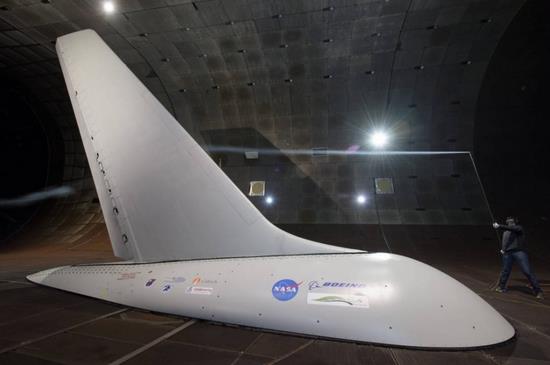
These NASA Innovations Could Cut Carbon Emissions and Save Airlines Billions.
Our race to the moon did have a positive effect on innovation and
technological reinvention; the same thing happening with renewable
energy; new ways to power the economy that require less (or no) fossil
fuels. Here's a snippet from The Washington Post: "NASA
research aimed at cutting fuel consumption, pollution and noise from
airplanes could pay off for the nation’s airlines to the tune of more
than $250 billion dollars, the agency said this week. Green technologies
developed by the research project are expected to save billions of
gallons of fuel if implemented, cutting carbon emissions and reducing
air pollution in the process..."
Photo credit above: "Researchers
with NASA’s Environmentally Responsible Aviation project coordinated
wind-tunnel tests of an Active Flow Control system — tiny jets installed
on a full-size aircraft vertical tail that blow air — to prove they
would provide enough side force and stability that it might someday be
possible to design smaller vertical tails that would reduce drag and
save fuel." (Courtesy of NASA/Dominic Hart)
Saving Suburbia.
How do we make the 'burbs more diverse, interesting and sustainable,
relying less on fossil fuels? A significant challenge, but not
impossible, according to an article at Nautilus: "...The
monotony does more than crush souls. It takes a lot of energy to
maintain a stubborn uniformity amid a range of natural environments.
Green lawns in Arizona’s Sonoran desert sap limited reservoirs, and heat
runs full-blast for most of the year in Wisconsin’s old wooden houses.
Sam Rashkin, author of the 2010 book Retooling the U.S. Housing Industry
and a chief architect at the U.S. Department of Energy in Washington,
D.C., says things need to change. “The thing we can’t keep doing is
building suburban developments that don’t work,” Rashkin says. Today’s
suburbs waste too much energy, pollute the environment and their
inhabitants, and are strikingly dull..."
The 13 Most Underrated Movies of 2015. Here's an excerpt of one short-list, courtesy of Variety: "...But
despite a challenging year for indie films, there are still
distributors eager to deliver material, including Netflix, Amazon, The
Orchard, Broad Green, A24 and Bleecker Street. As the independent-film
market tries to stay afloat, some of these players will need to discover
the right formula — between VOD and theatrical releases or some
combination — that can deliver smaller movies to bigger crowds. For now,
here are the most 13 underrated titles of 2015 that deserve another
look..." (Photo credit: SPC).
How Commercials Get Us To Buy Stuff We Don't Need. 3,500 ads a day? And that's just before lunch. Here's an excerpt from TreeHugger: "...Unless the company or product or marketing campaign is an extreme outlier (as some of Patagonia's advertising is),
or unless we're ad-blocking ninjas both online and off, we're getting
exposed to some 3500 advertisements each day that all want us to do one
thing - buy more stuff. How do they do it? This quick video from AJ+, featuring Jonah Sachs, founder of Free Range Studios (which produced The Story of Stuff and The Meatrix),
lays out some of the psychological tactics used in commercials and
advertising, among which is instilling in us a fear of missing out..." What a Face.
Thanks to Kent Kruhoeffer, who snapped this memorable photo with his
smartphone in Tangshan, China. I know just how this little guy feels...
TODAY: Sunny and a bit chilly. Feels like -20F. Winds: W 10-15. High: 2
SATURDAY NIGHT: Partly cloudy and numbing. Low: -10
TUESDAY: Second arctic shot, feels like -25 to -30F. Winds: NW 10-20. Wake-up: -4. High: near 0
WEDNESDAY: Mostly cloudy, still numb. Wake-up: -10. High: 9
THURSDAY: Blue sky, plenty of fresh air! Wake-up: -6. High: 8
FRIDAY: Clouds increase, late flurries. Winds: E 10-20. Wake-up: 0. High: 13
SATURDAY: Better chance of a snowy coating. Winds: E 8-13. Wake-up: 10. High: 17
Climate Stories...
Global Warming, El Nino Combine to Fuel Extreme World Weather. Here's the intro to a story at Voice of America: "A
series of weather disasters has shaken the world in recent weeks, with
deadly floods in the United States and Britain adding to ongoing
droughts in Brazil, South Africa and India. Global warming is partly to
blame because it heats up the world's oceans and sends evaporated water
into the atmosphere, where it generates more heat, says Jeff Masters,
director of meteorology at U.S. online news service Weather Underground..."
The Farce Awakens: Deniers Dispute 2015's Record Heat.
Don't like the implications of minor details such as data, facts and
evidence? Question the scientists, the instruments, even the scientific
method. Cherry-pick the data that fits your ideological narrative, throw
everything else out, and when you get boxed into a corner start
shouting conspiracy theories. That sounds about right. Here's an excerpt
from ClimateDenierRoundup: "...As
legitimate media sources start reporting on the reliable thermometer
record showing 2015 as a record-hot year, we can expect deniers to push
back with the satellite data. But that puts them in the uncomfortable
position of admitting that, even according to this problematic data, the
three hottest years have occurred since 1998, which doesn't exactly
support the position that there's been no warming. Denier's nonsensical
reliance on the satellite record (which only goes back to 1979) ignores
the history of errors with this data and the fact that satellites infer,
based on complex measurements, temperatures up in the atmosphere and
don't calculate those on the ground or in the ocean. So deniers are
ignoring the historical record that dates back to the 1800s, as well as
the ocean - which absorbs 93% of the heat added due to global warming -
and actual physical temperature measurements, in favor of
repeatedly-corrected air temperature measurements...."
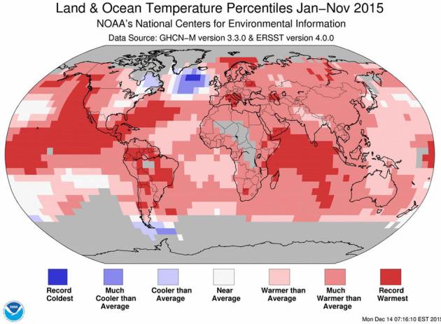
January - November, 2015 global temperature anomalies (land and ocean) courtesy of NOAA NCDC. Pope Francis Was Right on Climate Change. Here's an excerpt of an Op-Ed at The Washington Post: "...That’s
why many environmental activists are now being drawn to an evolving
philosophical stance on the topic, shifting away from an approach that
is simply political, scientific or economic. “There can be no ecology
without an adequate anthropology,” Pope Francis said in Laudato Si, the papal encyclical released last summer.
Francis rejected both an anthropocentric view that accepts all human
desires and a misanthropic view that wishes people would disappear. To
find solutions for climate change and other environmental challenges, we
need to focus on the morality of our actions, including questions of
fairness and obligation..."
This Settles It: Cold Days Are Superior to Hot Days. We tend to feel better, overall, on chillier days than on (stinking) hot days, according to some new research highlighted at The Washington Post: "...Baylis
ran some back-of-the-envelope calculations and found that a one-degree
increase in temperature has an effect on your happiness that's similar
to living in an area with a median income that is $500 lower. This
starts to have implications for what we know about the effects of global
warming. Economists have done a pretty good job of calculating the
costs of higher temperatures when it comes to things such as crop yields
and economic productivity. But, Baylis says, "we are underestimating
the social costs of carbon..."
AGU's "Sharing Science" is Helping Scientists Talk To The Rest of Us.
Accurately communicating climate science in a way that hits them in
their heads and their hearts is challenging, a work in progress. But
there are tools and resources to help. Here's an excerpt from my friend
and St. Thomas climate scientist John Abraham at The Guardian: "...Perhaps the most prestigious communication honor is the annual Climate Communication Prize. The past five winners are really the who’s-who among our community. I asked the most recent winner, Dr. Richard Somerville, about the importance of communication, particularly for young scientists. He told me, 'I
encourage all scientists, including young scientists, to explore the
opportunities for communicating their science and to seek help from
professionals. Nobody is born a great communicator, but it involves
skills that can be learned. Many universities and research institutions
have helpful experts on staff whose job is to translate the science into
everyday English for the media and other outlets. I have benefited by
working for more than 20 years with a superb communications
professional, Susan Joy Hassol. On the website climatecommunication.org, she and I and our colleagues have assembled many valuable resources for communicating climate science'...


No comments:
Post a Comment