...WHITEOUT CONDITIONS POSSIBLE LATE SUNDAY INTO EARLY MONDAY...

.A BLIZZARD WATCH CONTINUES FOR WEST CENTRAL...SOUTHWEST AND
PORTIONS OF SOUTH CENTRAL MINNESOTA SUNDAY AFTERNOON THROUGH
MONDAY MORNING. THIS WATCH IS LOCATED ALONG AND WEST OF A LINE
FROM ALEXANDRIA TO ALBERT LEA.

WIND GUSTS OF 40 TO 50 MPH ARE EXPECTED TO DEVELOP OVER MUCH OF
THE AREA BY SUNDAY AFTERNOON AND LAST THROUGH MONDAY MORNING. THE
WIND COMBINED WITH FALLING LIGHT SNOW AND EXTENSIVE SNOWPACK MAY
RESULT IN CONSIDERABLE BLOWING AND DRIFTING SNOW...WITH POSSIBLE
WHITEOUT CONDITIONS. DIFFICULT TRAVEL IS LIKELY AND ROAD CLOSURES
MAY BE POSSIBLE.

A WINTER WEATHER ADVISORY HAS BEEN ISSUED FOR AREAS EAST OF THE
BLIZZARD WATCH FOR SNOW AND BLOWING SNOW DEVELOPING SUNDAY
AFTERNOON AND LASTING THROUGH MONDAY MORNING.

WIND GUSTS OF 30 TO 40 MPH ARE EXPECTED TO DEVELOP OVER THE
ADVISORY AREA SUNDAY AFTERNOON AND LAST THROUGH MONDAY MORNING.
THE WIND COMBINED WITH FALLING LIGHT SNOW AND EXTENSIVE SNOWPACK
WILL RESULT IN WIDESPREAD BLOWING AND DRIFTING SNOW...WITH LOW
VISIBILITIES AT TIMES. TRAVEL WILL BECOME DIFFICULT SUNDAY
AFTERNOON AND EVENING AS WINDS INCREASE.
...WINTER WEATHER ADVISORY IN EFFECT FROM NOON SUNDAY TO NOON CST
MONDAY...

THE NATIONAL WEATHER SERVICE IN TWIN CITIES/CHANHASSEN HAS ISSUED
A WINTER WEATHER ADVISORY FOR SNOW AND BLOWING SNOW WHICH IS IN
EFFECT FROM NOON SUNDAY TO NOON CST MONDAY.

* EXPECT SNOW TO DEVELOP AROUND NOON SUNDAY AND THEN DIMINISH
  AROUND NOON MONDAY.

* THE HEAVIEST SNOWFALL RATES WILL OCCUR BETWEEN NOON AND 6 PM
  SUNDAY.

* TOTAL SNOW ACCUMULATIONS OF 1 TO 3 INCHES ARE EXPECTED.

* WINDS GUSTING AS HIGH AS 45 MPH WILL CAUSE AREAS OF BLOWING
  AND DRIFTING SNOW.

* PLAN ON SLIPPERY ROAD CONDITIONS.
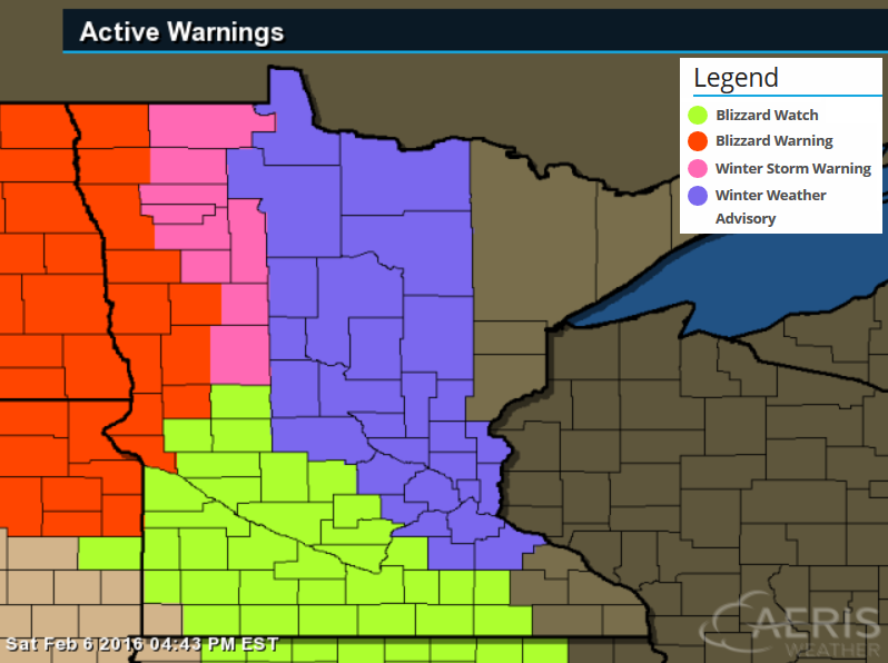
"A potent system will drop southeast from Canada Sunday and bring periods of light snow. Behind it, very strong northwest winds gusting in excess of 50 to 60 mph are likely late Sunday into Monday across western and southern Minnesota. This may result in considerable blowing snow and whiteout conditions in areas with deep snowpack. Blizzard Watches remain in effect."
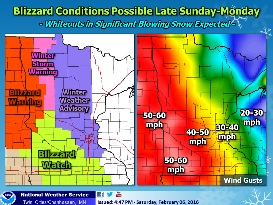
Ground Blizzard Risk Just South and West of MSP
By Paul Douglas
America hosts an average of 105 snow-producing storms every winter. "Chionophobia" is a persistent fear of snow, especially being trapped by drifts. The average snowflake falls at a lethargic 3 mph.
That, and you don't need falling snow to whip up a "blizzard". Sustained winds over 35 mph can blast snow already on the ground into a frothing frenzy, dropping visibility near zero.
We may see these conditions over southwestern Minnesota later today, where a Blizzard Watch has been posted. Get your travel done early from Alexandria and Willmar to Mankato; the drive home from that Super Bowl party may be pretty rough.
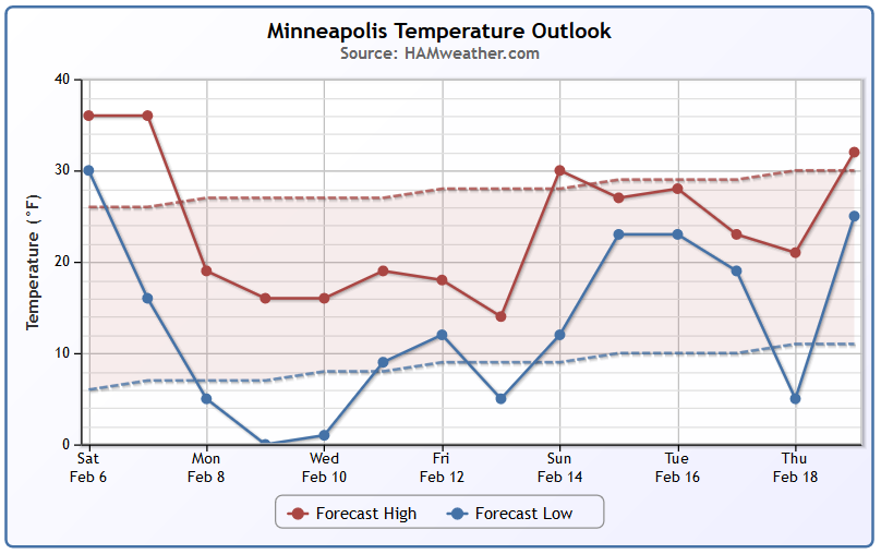
Mid-30s will feel good today, but parkas return this week with a streak of teens and single digits all week long. By Saturday the mercury serves below 0F. Nothing shocking for mid-February though.
The pattern won't favor any big, sloppy southern snowstorms, just a family of clippers. Expect an inch or two tonight, maybe a couple inches Wednesday. Enough to freshen up your yard.
The sun is climbing ever-higher. I see slight moderation the latter half of February.
___________________________________
Extended Forecast
SATURDAY NIGHT: mild. Chance of a few rain showers changing to a wintry mix. Winds: SSW 10-15. Low: 33
SUNDAY: Blizzard Warning western Minnesota. Winter Weather Advisory for Central MN, including the Metro. Overcast, mild start. Snow arrives late, less than half inch late Sunday with drifting. Winds: NW 15-30. High: 35.
SUNDAY NIGHT: Windy with light snow and blowing snow. Less than 1" possible. Winds: NW 25-35. Low: 15.
MONDAY: Slow, slippery AM commute? Gusty, colder with drifting snow. Winds: NW 15-30. High: 18
TUESDAY: Peeks of sun, feels like -5. Winds: NW 10-15. Wake-up: 3. High: 12
WEDNESDAY: Few inches of powdery snow? Winds: N 10-15. Wake-up: 0. High: 11
THURSDAY: Partly sunny, feels like February. Winds: NW 8-13. Wake-up: -3. High: 13
FRIDAY:Mostly cloudy, parka weather. Winds: NW 10-15. Wake-up: 6. High: 10
SATURDAY: Cold start, fading sun. Winds: NW 5-10. Wake-up: -10. High: 7.
____________________________________
This Day in Weather History
February 7th
1857: A snowstorm dumps around 9 inches of snow at Fort Snelling.
_____________________________________
Average High/Low for Minneapolis
February 7th
Average High: 27F (Record: 53F set in 1987)
Average Low: 10F (Record: -29F set in 1875)
_____________________________________
Sunrise/Sunset Times for Minneapolis
February 7th
Sunrise: 7:25am
Sunset: 5:29pm
*Daylight Gained Since Yesterday: ~2mins & 44secs
*Daylight Gained Since Winter Solstice: ~1hour & 14mins
______________________________________
Moon Phase for February 7th
0.3 Days Before New Moon

_______________________________________
Minneapolis Temperature Trend
The extended forecast suggests a fairly decent dip in the temperature department through much of next week. We may get back to near average reading by mid month.
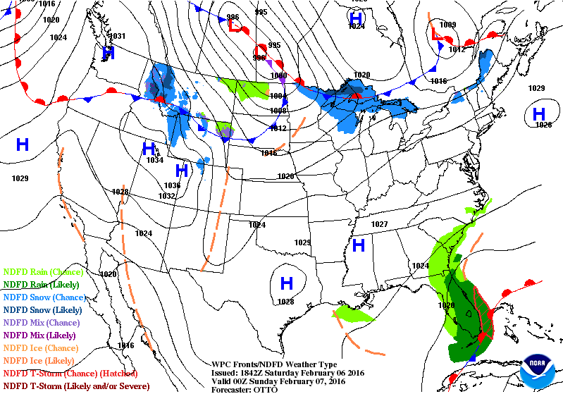
Sunday Weather Outlook
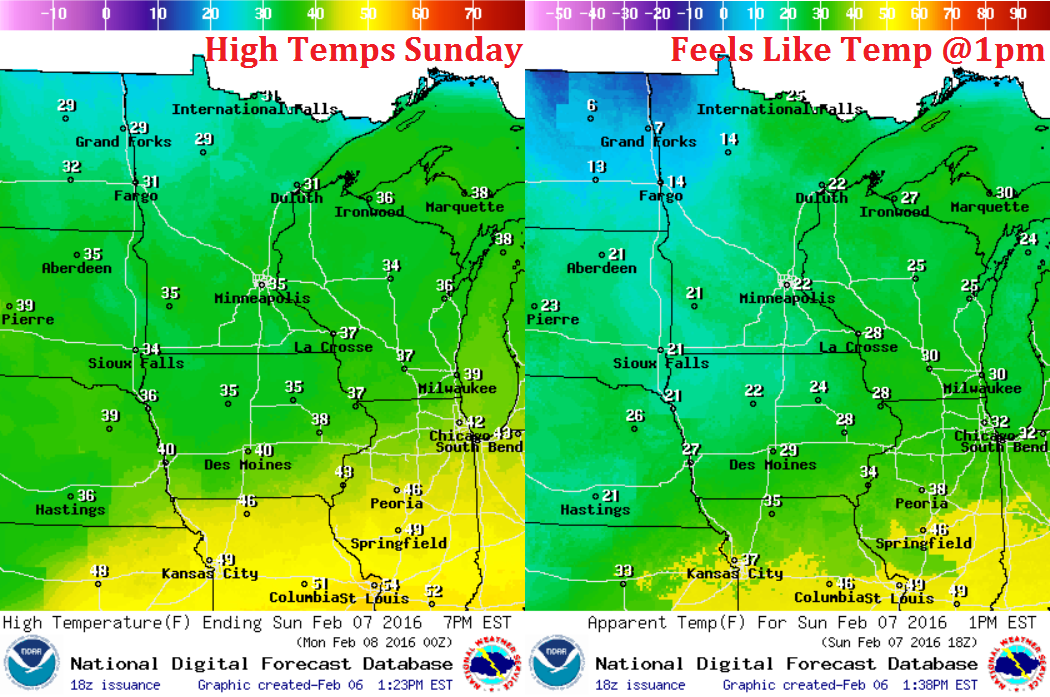
It'll be a mild day Sunday with temperatures in the 20s and 30s across the state. However, a fairly potential storm system will move through the region with gusty winds developing during the day. Note that feels like temperatures will be dipping into the single digits and teens across the northern part of the state by midday.
Sunday Weather Outlook
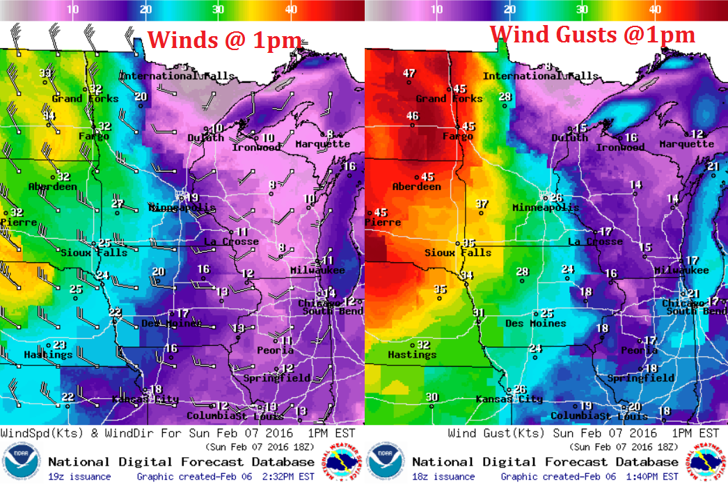
Look at the winds picking up across the Dakotas and western Minnesota by midday! Sustained winds of 20-30mph+ and wind gusts to 40-50mph+ along with falling and blowing snow could make for white-out conditions across those areas.
Sunday Weather Outlook
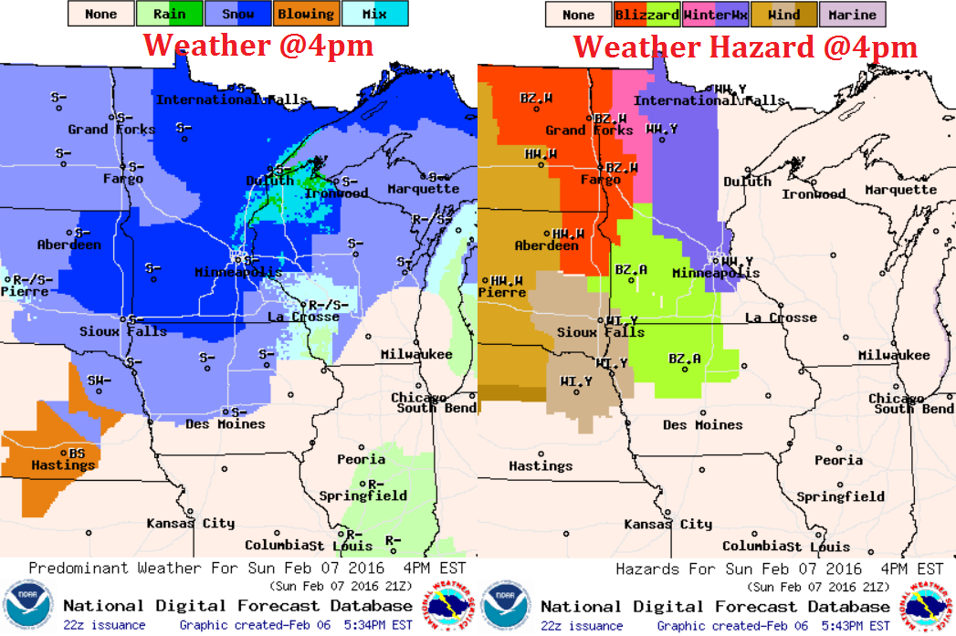
Here's the weather outlook by 4pm... light snow with gusty winds will create areas of blowing snow and potential blizzard-like conditions across the Dakotas and western MN.
__________________________________
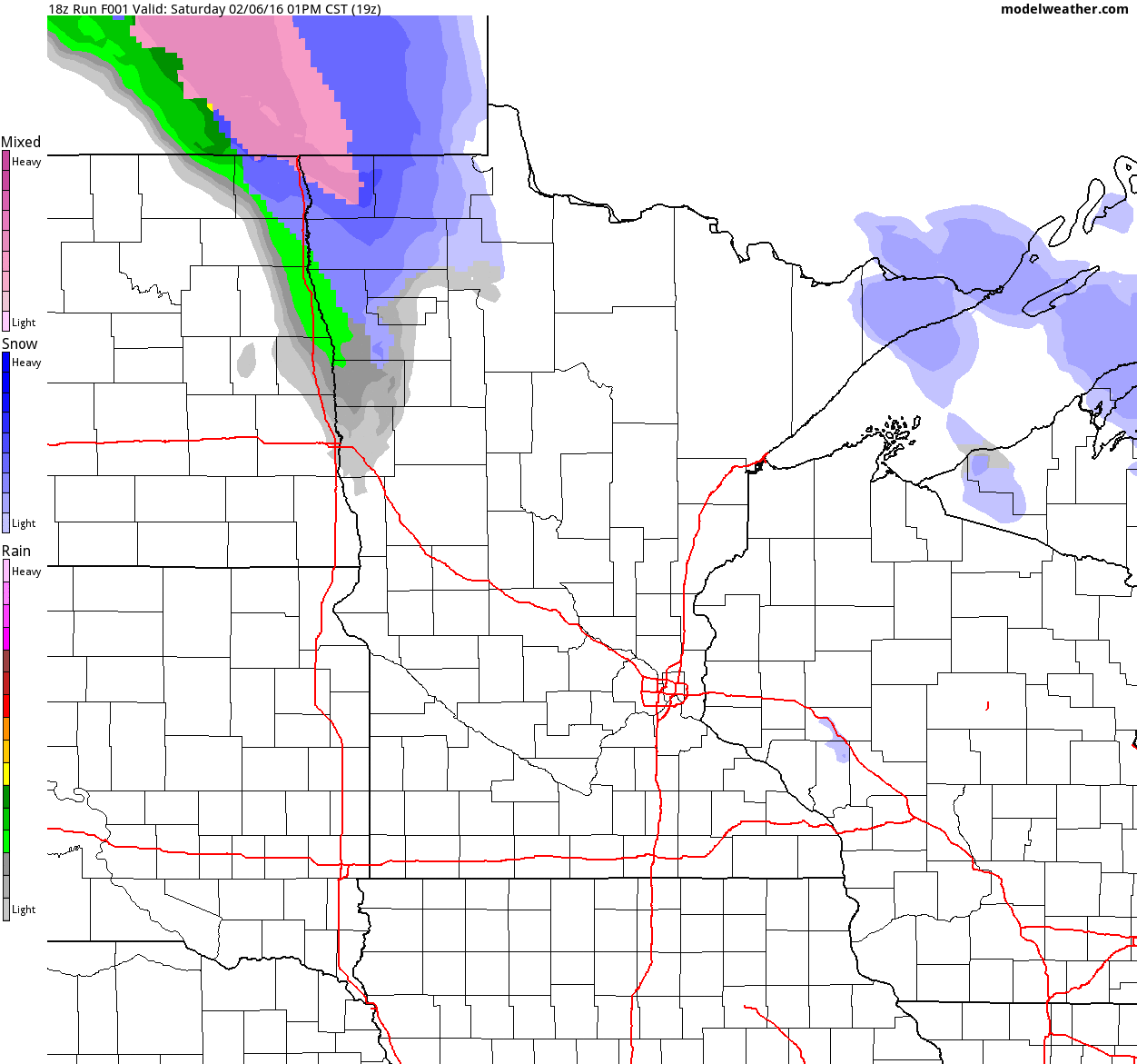
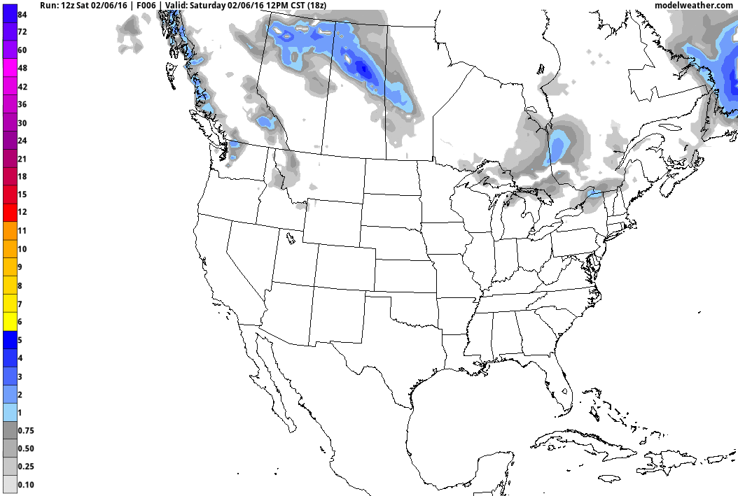
Simulated Radar
Here's the storm system that'll be swirling through the region Sunday into Monday. Note that initially it may be warm enough for a rain/snow mix, but snow showers will be predominant precipitation type PM Sunday through Monday.
______________________________________
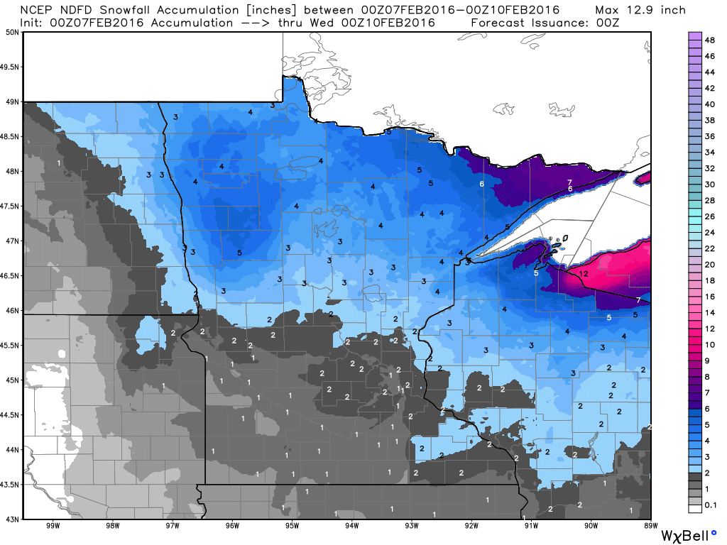
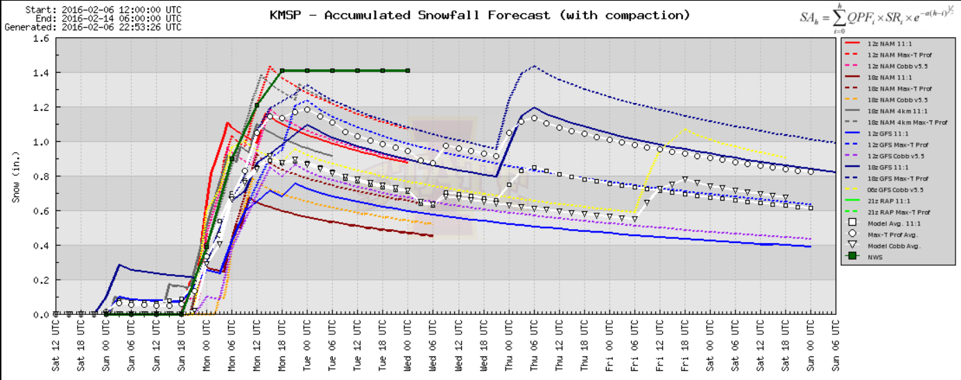
Snowfall Potential
Here's the snowfall potential through 6pm Tuesday, which shows the heaviest snowfall potential across northern Minnesota.
Minneapolis Snowfall Potential
Here's the snowfall potential, which shows maybe 1" of snow through early Monday.
National Weather Outlook
Here's the powerful clipper as it moves through the Midwest and into the Great Lakes through early next week. Although snowfall amounts won't be heavy, winds will be strong enough to create significant blowing and drifting. Blizzard-like conditions will be possible across parts of the Dakotas and Upper Midwest through early next week.
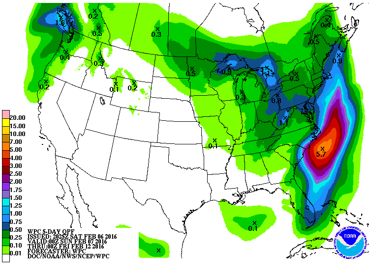
5 Day Precipitation Outlook
According to NOAA's WPC, the 5 day precipitation outlook suggests heavier precipitation moving through parts of the Great Lakes through early next week. However, note the heavier blob just east of the Mid-Atlantic Region and parts of the Northeast. Some of this could turn into snow potential through the weekend.
Snowfall Potential
The clipper system moving through the Midwest/Great Lakes and another system moving through parts of the Northeast through the weekend/early next week will bring some shovelable/plowable amounts of snow to some of these areas.
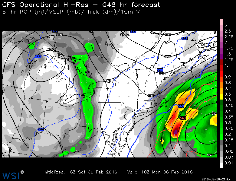
Northeast Coastal Snow Potential
A storm system developing off the East Coast will bring heavy moisture along the near shore... it'll be a close call for those along the coast. Heavy snow may be possible for those in eastern Mass.
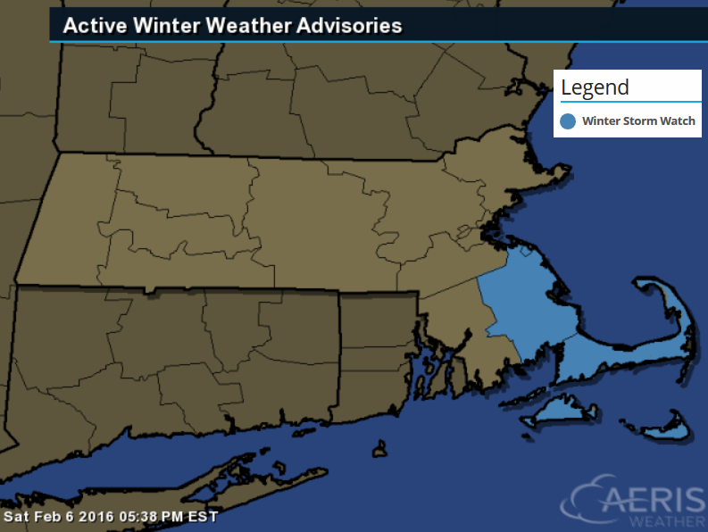
Winter Storm Watch
...WINTER STORM WATCH IN EFFECT FROM MONDAY MORNING THROUGH
TUESDAY MORNING...

THE NATIONAL WEATHER SERVICE IN TAUNTON HAS ISSUED A WINTER STORM
WATCH...WHICH IS IN EFFECT FROM MONDAY MORNING THROUGH TUESDAY
MORNING.

* LOCATIONS...SOUTHEAST MASSACHUSETTS INCLUDING CAPE COD AND THE
  ISLANDS. THIS INCLUDES THE CITIES AND TOWNS OF BROCKTON...
  PLYMOUTH...MATTAPOISETT...CHATHAM...FALMOUTH AND PROVINCETOWN.

* HAZARD TYPES...SNOW.

* ACCUMULATIONS...SNOW ACCUMULATION OF 4 TO 7 INCHES ARE POSSIBLE
  ACROSS THE WATCH AREA MONDAY AND MONDAY NIGHT.

* UNCERTAINTY...THE EXACT TRACK OF AN OCEAN STORM REMAINS
  UNCERTAIN. IF THE STORM TRACKS CLOSER TO THE COAST HEAVIER SNOW
  AMOUNTS WILL BE POSSIBLE AND FARTHER INLAND. CONVERSELY IF THE
  STORM TRACKS FARTHER OUT TO SEA LESS SNOWFALL CAN BE EXPECTED.

* TIMING...SNOW OVERSPREADS THE WATCH AREA MONDAY MORNING AND
  AFTERNOON...CONTINUING THROUGH MONDAY NIGHT.

* IMPACTS...ANYONE TRAVELING IN THE NEXT 24 TO 36 HOURS SHOULD
  MONITOR LATER FORECASTS AND BE PREPARED TO MODIFY TRAVEL PLANS
  SHOULD WINTER WEATHER DEVELOP.

* WINDS...NORTHEAST 20 TO 30 MPH WITH GUSTS UP TO 45 MPH.

* VISIBILITIES...MAY BE REDUCED AT TIMES TO A 1/2 MILE OR LESS.
___________________________
Is the Zika Outbreak Connected to Climate Change?
"Zika requires a specific type of mosquito to spread (though, in limited cases, it may also be sexually transmitted). As with all mosquito-borne diseases, Zika has a link to climate. The WHO cited an especially strong El Niño, which tends to shift temperature and rainfall patterns in predictable ways, as a reason why Aedes aegypti — one of two types of mosquitoes known to transmit Zika — could have a further range than normal over the coming months. It doesn’t help that Aedes mosquitoes are particularly well-adapted to cities, especially those in drought-stricken Brazil where people are, understandably, trying to conserve every drop of water they can in whatever containers they can find. There’s also some evidence that climate change may have already given the mosquito greater leeway to survive further up mountainsides and deeper into cooler climates, like California. In recent years, the mosquito has been spotted as far north as Washington, D.C. — and it now survives year-round in parts of Arizona, Texas, and Florida."
See more from grist.org HERE:

____________________
Thanks for checking in and have a great rest of your weekend! Don't forget to follow me on Twitter @TNelsonWX

No comments:
Post a Comment